Station Name: AUDLEY END
(Saffron Walden Branch Platform) |
 |
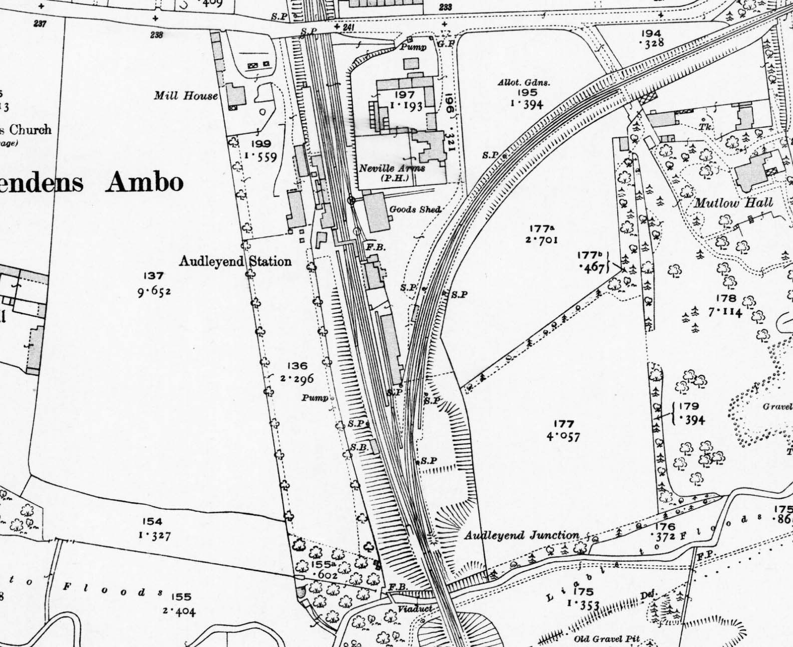 Audley End station and environs on a 1919 1:2500 OS map. In comparison with the 1877 map, a number of changes to track layout are apparent and not least on the Saffron Walden branch. The long siding has appeared and extends as far as Mutlow Hall level crossing, while a trap siding has appeared at the long siding's southern end. The trap siding from the branch platform loop has been realigned and now extends closer to the viaduct. In the main line department, a third trap siding has appeared, protecting the junction of the up main line from Barnard Brothers siding. The footbridge is shown connecting the staggered up and down platforms but the goods shed is now served only be one road. The southernmost of the two goods shed wagon turntables is still apparently in existence, but the road from it into the south end of the shed has been lifted. The reason is clear from the map; the installation of yet another trap siding - this time adjacent to the west face of the shed. The area between the goods shed and the station building (where F.B. is seen) is a small goods dock. The larger cattle dock is seen to the north of the station on the up side, immediately south of the Station Road bridge. there is a livestock pen at the north end of the dock. The wagon turntable and short siding serving the gasworks has gone although the gasworks itself still exists but is not marked as such. Small rural gasworks' were once very common with some, including that at Audley End, being built by railway companies but many had ceased to operate in the years prior to WWII. Audley End station and environs on a 1919 1:2500 OS map. In comparison with the 1877 map, a number of changes to track layout are apparent and not least on the Saffron Walden branch. The long siding has appeared and extends as far as Mutlow Hall level crossing, while a trap siding has appeared at the long siding's southern end. The trap siding from the branch platform loop has been realigned and now extends closer to the viaduct. In the main line department, a third trap siding has appeared, protecting the junction of the up main line from Barnard Brothers siding. The footbridge is shown connecting the staggered up and down platforms but the goods shed is now served only be one road. The southernmost of the two goods shed wagon turntables is still apparently in existence, but the road from it into the south end of the shed has been lifted. The reason is clear from the map; the installation of yet another trap siding - this time adjacent to the west face of the shed. The area between the goods shed and the station building (where F.B. is seen) is a small goods dock. The larger cattle dock is seen to the north of the station on the up side, immediately south of the Station Road bridge. there is a livestock pen at the north end of the dock. The wagon turntable and short siding serving the gasworks has gone although the gasworks itself still exists but is not marked as such. Small rural gasworks' were once very common with some, including that at Audley End, being built by railway companies but many had ceased to operate in the years prior to WWII.
 Home Page Home Page
| Last
updated: Friday, 12-May-2017 19:45:11 CEST |
© 1998-2015 Disused Stations
| |
