
Station Name: BANBURY MERTON STREET
old8.jpg)
Another view from March 1966, this time from the platform and closer to the station. Visible are the electric lamps installed after closure to passengers, the reason for which mystery retains the upper hand. The small cabin on the right was presumably a ticket collector's booth. A light in on inside it apparently but whether it as also electric or still gas is not known. Close examination reveals the running-in board, centre of picture, has lost its name. On the right a British Road Services Leyland lorry peeps around the corner at the camera. On the roofs of the houses, right background, at least two 'X' shaped television aerials can be seen. These comprised dipole and director elements and were Band 1 aerials for BBC reception. They were unsuitable for Band 3 (ITV) reception due to problems with low gain. The once common X and H aerials are now obsolete but many still exist, clinging defiantly to chimney stacks as they have done for decades.
Photo by John Evans from his Flickr photostream old9.jpg) The familiar view of Banbury Merton Street facing towards the buffers, this time in March 1966 and three months before total closure. Since the end of passenger services five years previously, just about everything had been left as it was. Perhaps the most noticeable change from the station's former years is the complete absence of cattle wagons on the right. In theory cattle traffic was still active but the fenced-off cattle dock suggests otherwise while other photographs suggest this part of the cattle dock was used by British Road Services for lorry parking. It appears all the terraced houses, right background on Merton Street, now have television but at least one can still only receive BBC 1 as it became after the launch of BBC 2 two years previously. The Merton Street goods shed is
seen on the left. Photo by John Evans from his Flickr photostream old10.jpg)
One of Merton Street's LMS 'hawkeye' running-in boards as photographed in March 1966. This board was towards the outer end of the platform, that within the trainshed have lost its name by this time. The station name was originally simply 'Banbury', with the Merton Street suffix added in 1910. Over on the GWR, the present day station began life as Banbury Bridge Street before reverting to simply Banbury until another renaming to Banbury General (it now once again simply Banbury). It is known that Merton Street's original LNWR boards remained in place until well into LMS days, so it is likely the LMS decided to add the 'Merton St' suffix during the period when both stations were named simply 'Banbury'. In this photograph the wood of the stanchions, frame and backboard appear to be in good condition although the coat of paint, which would never come, is long overdue. It is thought the LMS 'hawkeye' nameplates at Merton Street, if not elsewhere, were one-piece aluminium alloy castings and this certainly looks to have been the case but confirmation would be welcome. It is believed one of the Merton Street nameplates survived, probably that within the trainshed, but attempts to confirm this had, at the time of writing, proved unsuccessful.
Photo
by John Evans from his Flickr photostream
old11.jpg)
March 1966 again but this time the camera has ventured along the line to the site of Merton Street's former engine shed and associated facilities, the water tower being in-shot here. In the left background stands the signal box and, beyond it, the station. Yard lighting is electric but when this was installed is unknown; as noted with other photographs electric lighting was installed on the station after it had closed to passengers but this is unlikely to have applied to the yard lighting although it is not impossible as BR could do some seemingly odd things at times. The tracks appear to have not been used for some time and although track through to Verney Junction remained in situ until 1967 it seems likely that by 1966 goods traffic at Merton Street all operated via the connection to the former GWR route. The curve in the track marks the point where the line swung eastwards towards the wild and lonely Cockley Brake Junction some five miles away. At that point two single track lines diverged; the former Northampton & Banbury (later a spur link of the SMJ) continuing more or less straight ahead towards Towcester while the former LNWR route swung southwards towards Brackley and Buckingham.
Photo by John Evans from his Flickr photostream old41.jpg) Looking along the platform at Banbury Merton Street from the concourse, such as it was, in March 1966 and over five years since closure to passengers. The two tracks serving the platform were by now nothing more than sidings for wagon storage (the wagons on the right are on an adjacent siding). On the left a length of planking has fallen across the Up platform road, or perhaps it had been deliberately placed as a crude way of telling train crews not to shunt into the dilapidated station. As we shall see, the plank was to remain there for some time. It is interesting to observe that despite gas lamps being still present, electric lighting has also been installed. These were installed at some point after the station closed to passengers but why is a mystery as there is no evidence of British Road Services, who by this time were occupying the station, using the platform for whatever purpose. Towards the top right of the photograph it can be seen that one of the gas lamps has been completely removed but at least two remain. It is possible that due to the condition of what remained of the trainshed, the gas supply had been disconnected for safety reasons but, even so, quite why the expense of installing electric lighting was deemed necessary is a mystery. In the distance stands Merton Street signal box which, by this date, was probably opened only as required for goods traffic which, in any event, was to cease three months later. The cattle dock sidings, left of centre, appear disused although Midland Marts would maintain a presence at the site until 1998. Railway cattle traffic was, in any event, in rapid decline by 1966. Beyond the signal box and in front of the gasometer (commonly 'gas holder') a rake of wagons can just be discerned. They are standing on the connecting link, rather one of them, to the former GWR line and are perhaps awaiting collection and forwarding from Banbury General. Information on Banbury gasworks is given in a similar image caption below.
Photo by John Evans from his Flickr photostream old12.jpg)
Banbury Merton Street station forecourt after the station building and immediate environs had been taken over by British Road Services as a depot. The sidings, however, were still open for goods traffic at this time and would remain so for a further two months, this photograph dating from April 1966. There has been some minor changes to the station building such as repainting of window and door frames. The enormous station nameboard is still in position but minus name while a British Road Services nameboard has been perched above it. The No Parking signs were two of several dotted around the site, presumably because of lorry and trailer movements. The free-standing Police Notice is curious and one wonders, if police assistance was required, if it would be the responsibility of the civil or British Transport Police but one would assume the latter. British Road Services, more usually referred to simply as 'BRS' were born out of Nationalisation in 1948 and therefore came under the British Transport Commission along with British Railways and other industries. BRS lasted in its original form until 1963 when, as a result of the Transport Act 1962, it came under the wing of the Transport Holdings Company, better known as THC and perhaps more familiar for operating buses which in due course came to be the National Bus Company. The year 1963 brought a number of other companies under the same umbrella, the best known being Pickfords. BRS subsequently underwent further changes before becoming the National Freight Corporation (NFC) which brought with it a majority stake in Freightliner although this was later transferred back to British Railways. Enter Margaret Thatcher and privatisation. In 1980 NFC became the National Freight Company through a transfer of assets before being sold in 1982 to become the National Freight Consortium, a employee buyout. The Pickfords business was sold off, as was the parcels business side of the business in a management buyout which traded as Lynx Express. What remained of what began life as BRS eventually became part of Exel, actually an offshoot of Deutsche Post and with links to DHL. The situation remained more or less the same in 2018, still owned by Deutsche Post but, now absorbed by DHL, is now headquartered in the United States. And we think rail privatisation is complex!
Photo by John Evans from his Flickr photostream old13.jpg) Following on from the previous photograph, this is the same scene one month later in April 1966. Nothing has changed with the exception of a rake of wagons being stabled on the Down platform road. The fact the wagons have stopped at the end of the trainshed, or what remained of it, may add weight to the possibility staff were instructed not to shunt wagons into the dilapidated trainshed. The wagon nearest the camera is a 'HiBar'. Used for goods needing protection from the weather, they were, when necessary, covered by a tarpaulin which was pitched by means of raising the pivoting bar visible here. In this and the previous photograph, Banbury goods yard crane can be seen on the right. On 3 October 1940 the area around the gasworks was bombed by the Luftwaffe. Two of the three gasometers then in existence were destroyed, one receiving a direct hit, while the main line and sidings of the GWR were damaged. Sadly there were six deaths all of whom were railwaymen. Banbury's original gasworks dated from 1833 and it stood alongside the Oxford Canal, for coal deliveries - barges being at the time the only means of transporting coal in bulk, to the south-west side of the future GWR line through the town. The actual site of the original gasworks was near the south-west end of what is now Tramway Road and close to Britannia Works, the site of which is in 2018 occupied by a Morrisons supermarket on Swan Close Road. Britannia Works produced agricultural machinery including smaller items such as lawnmowers and with the coming of the railway to Banbury opened additional premises on the Down side of the GWR. Some of the former Britannia buildings adjacent to the railway still stand as of 2018. A tramway was constructed to connect the company's two sites. The tramway ceased operation sometime around 1935 and what is now Tramway Road more or less follows the course of it. As Banbury grew and, more relevantly, the railways arrived in the town thus making coal deliveries far more efficient, a new gasworks was deemed necessary. Located between the GWR and LNWR lines, it opened in 1854 and is the gasworks seen in this and numerous other photographs. However, by the time of this photograph the gasworks had ceased gas production, in 1958, and what was destined to become the sole remaining gasometer used only for storage and pressurising of gas piped in from elsewhere - presumably Oxford. The gasworks had a total of four gasometers but not all existed simultaneously. That seen in this photograph, the sole survivor mentioned, had been erected in 1942 and presumably to replace those wrecked by the Luftwaffe two years previously. By understanding gas supplies had to be maintained as best as possible, two years may seem a long time to replace the wrecked gasometers but this was wartime and under such conditions erecting the new gasometer within two years was creditable. To quote a wartime maxim which has re-emerged on novelty goods today, in 1942 it was a case of 'Keep calm and carry on' even in the face of possible further air raids and gas explosions. The decline of the railway to Merton Street began in 1951 with the closure to passengers of the line from Cockley Brake Junction to Towcester and beyond although, arguably, the loss of this line, which skillfully managed to avoid most centres of population along the way, was no great hardship. The cessation of gas production at Banbury in 1958 was a bigger blow as it meant a significant loss of coal traffic by rail but, a decade or so later, as natural gas came online, industries closed, domestic coal consumption dropped and the railways withdrew steam traction it became a pattern familiar across the country. North Sea gas reached Banbury in 1969 (the first location to be so-supplied was Burton on Trent the previous year) and would have been stored in the 1942 gasometer until more modern plant was introduced. Precisely when the Banbury gasometer was removed is unclear but Oxfordshire County Council record that it still existed in 1978 but had been demolished by 1999. Perhaps a reader with local knowledge can elaborate.
Photo by John Evans from his Flickr photostream old14.jpg)
Banbury Merton Street station forecourt after the station building and immediate environs had been taken over by British Road Services as a depot. This view dates from June 1966, the month and year the station, rather its goods facilities, finally closed to all rail traffic. Track would be lifted the following year. British Road Services (BRS) is briefly described elsewhere but on this occasion we get a glimpse of some of its vehicles in their smart red livery. Many people old enough to remember BRS will, however, probably better remember the awful all-over green livery later used. BRS operated a surprisingly varied fleet, from small 5 cwt vans to articulated lorries. They made little effort to standardise the fleet, probably because requirements for new vehicles were put out to competitive tender but this would not have been good from the spares and maintenance aspect. Visible in this photograph is a Leyland, either a Hippo or a Badger. Leyland produced a range of lorries named after animals, of which the most well known was perhaps the 8-wheel Octopus. The model name was given on a badge to the right, as we view, of the 'Leyland' name but in this instance it is unreadable. Hiding away behind the hut at the entrance to the goods yard is the cab unit of another, unidentified, lorry. Inside the yard stand a pair of AEC Mercurys with another Leyland hiding behind them. Other vehicles identifiable are a Morris Oxford Series II, left, and a Rover P6 2000 right. The Rover P6 was the sort of car a manager or some other senior official might have driven. When still on the drawing board, Rover intended to give the car a 'shark nose' vaguely resembling the front end of a Citroen DS. Fortunately this did not come to pass, apparently because of a forthright comment made by the Duke of Edinburgh during a visit to the factory. What did finally emerge was a popular car but one which, at the same time, was not to everybody's taste as it lacked the grandeur of its predecessor the P5B. But at least the P6 looked like a car, unlike many of the strange-looking offerings of the 21st century with embarrassing names.
Photo
by John Evans from his Flickr photostream
merton_street1.jpg)
Merton Street station forecourt in July 2005 during construction of new housing that now stands
on the site. Photo by Greg Scott merton_street3.jpg)
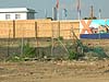
The end of
one of the goods docks in July 2005 during redevelopment of the station site.
Photo by Greg Scott merton_street4.jpg) The site of Merton Street station in December 2016. Merton Street is to the left. The building straight ahead stands on the Merton Street forecourt with the building behind on the site of the main station building at the back of the forecourt.
Photo by Nigel Thompson, reproduced from Geograph under creative commons licence merton_street5.jpg)
Looking south-east at the site of Banbury Merton Street station in May 2017. Merton Street station is on the left where the flats are seen. The road seen here is new, this was the vehicle access to the goods yard; the goods shed and weigh bridge would have been straight ahead. Today nothing remains of Merton Street station. Then road on the left is Marshall Road, a modern development named after Merton Street's last stationmaster, Arthur Marshall. The stationmaster at Merton Street was, after 1930, also responsible for Farthinghoe.
Photo
by Jerry Scott
Click on thumbnail to enlarge
|
merton_street_old29.jpg) The Railway Enthusiasts Club 'The Chiltern 200' railtour of 14 September 1963 is seen here being propelled along the connection between the former GWR at Banbury General (formerly Banbury Bridge Street) and the former LNWR Banbury Merton Street sidings. The train formation was four ex-GWR carriages and the propelling locomotive was ex-GWR Prairie Tank No.6111. Shortly after the photograph was taken, ex-LMS 2-6-4T No.42105, which was ready and waiting around the curve in the distance, coupled to this end of the train and took the tour on to Verney Junction and then onto the remaining stub of the former Metropolitan Railway to Winslow Road level crossing. This involved running round at Verney Junction with No.42105 propelling to Winslow Road. The train did not visit Banbury Merton Street station, by then closed to passengers, despite some confusion to the contrary. Fuller details of this interesting tour can be seen at
The Railway Enthusiasts Club 'The Chiltern 200' railtour of 14 September 1963 is seen here being propelled along the connection between the former GWR at Banbury General (formerly Banbury Bridge Street) and the former LNWR Banbury Merton Street sidings. The train formation was four ex-GWR carriages and the propelling locomotive was ex-GWR Prairie Tank No.6111. Shortly after the photograph was taken, ex-LMS 2-6-4T No.42105, which was ready and waiting around the curve in the distance, coupled to this end of the train and took the tour on to Verney Junction and then onto the remaining stub of the former Metropolitan Railway to Winslow Road level crossing. This involved running round at Verney Junction with No.42105 propelling to Winslow Road. The train did not visit Banbury Merton Street station, by then closed to passengers, despite some confusion to the contrary. Fuller details of this interesting tour can be seen at merton_street_old_thumb36.jpg)
old_thumb40.jpg)
old_thumb6.jpg)
old_thumb2.jpg)

 Home Page