
Cambridge - Its Railways and Station[Source:
Darren Kitson]
Part 2: The Pre-Grouping Period (continued) Signalling in the Station Area Until someone successfully invented yellow glass, the GER was one of several companies who sought to eliminate the problem by installing the Coligny-Welch distant signal lamp. These lamps were fitted in addition to the normal signal lamps and at night showed a white 'fishtail' shaped light which resembled the familiar notch in the outer end of distant signal arms. By this means, drivers could tell if the red light they were approaching was a 'stop' or 'caution' indication. Today, train drivers have to know every inch of 'the road' including, among a great many other things, where each signal is located, what type it is, what it protects and what its meaning is but in the early days of railways, knowledge of this depth was acquired on something of a 'know the basics and learn the rest as you go along' basis, hence the number of incidents involving red distant signals. That is not to say the first train drivers were incompetent buffoons, far from it, but rather the level of knowledge required before they could take charge of a train was by no means as extensive as it is today. Back in 1845 a combination of physical fitness, a good standard of literacy and some relevant engineering aptitude was the order of the day. All railway employees had to be literate and at that time literacy was not especially common outside the larger towns and cities, one reason why railway employees were held in high regard almost irrespective of their grade. The GER began installing Coligny-Welch (CW) distant signal lamps in 1899. Perhaps strangely, no photographic evidence has been seen to suggest CW lamps were fitted to distant signals in the immediate environs of Cambridge station. Further afield, CW lamps on the Stour Valley and Mildenhall branches became quite well known. The last CW-fitted signal in the Cambridge area is believed to have been Bottisham down distant on the Mildenhall branch, finally removed by the LNER in the1930s (possibly in 1935) as part of their drive to convert distant signals to the by-then-standard yellow+black arm and yellow lens type. The GER had been rather slow updating its signalling equipment, making do with the simple telegraph for communication between signal boxes. In 1871, however, 45 sets of Tyers equipment plus batteries were ordered for installation at Cambridge. Records actually state Tyers telegraph equipment' but that is presumed to mean 'block instruments'. A GER traffic notice issued on 22 April 1910 concerning engineering work at Central signal box mentions 'Block Telegraph Regulations'. In the late 19th century a number of signal boxes controlled Cambridge station; North, South, Central, Hills Road Junction and Mill Road Junction. Others on the fringes of the station area were Coldham Lane Junction, Trumpington, Cambridge Goods Yard (LNWR) and that on the original Newmarket line at the eastern end of the triangle. In the greater Cambridge area others at various times were Barnwell Junction, Chesterton Junction, Saxon Cement Works, Brookfields, Cherry Hinton. As many of these are covered on other Disused-Stations pages we will here concentrate only upon the signal boxes at the station and its immediate environs; North, South, Mill Road and Hills Road, all of which had two locations over the years, and Central. Nothing is known about that on the original Newmarket line other than its location.
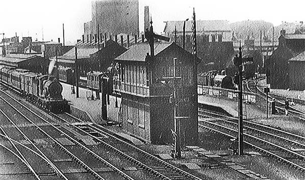
The above view dates from 13 August 1911 and shows the original Cambridge North signal box. By this time the main platform had been extended to 1515ft and, as can be seen, extended right up to the signal box. Note the ash pit and the GER shed in the background. The short canopy over platform 6, on the right, was provided by the GER for the Midland Railway following complaints from the latter. The locomotive on the left is a Claud Hamilton 4-4-0 and its train has three horse boxes in its formation. Passenger stock is a mix of bogie and at least one six-wheeler. Other six-wheeled stock can be seen in platform 5. Beneath the third passenger coach of the train one track of the original Newmarket line can just be seen as it turns sharply away from the platform. The original North and South boxes were equipped by Messrs McKenzie & Holland. The building on the extreme right is of interest. To access it locomotives had to first enter No. 4 road of the main shed and then reverse across the other main shed and stores roads. A single track can just be seen entering the shed. Originally large enough for just one locomotive, the building was later extended. It is always marked on plans as engine shed but was in fact a locomotive repair shop. The building survived, still performing its intended function, until Cambridge shed closed to steam. A photograph from 1954 exists showing an B1 Class locomotive under repair in the facility; at this time the building, or at least part of it, was of corrugated iron but later aerial photographs show a brick building.
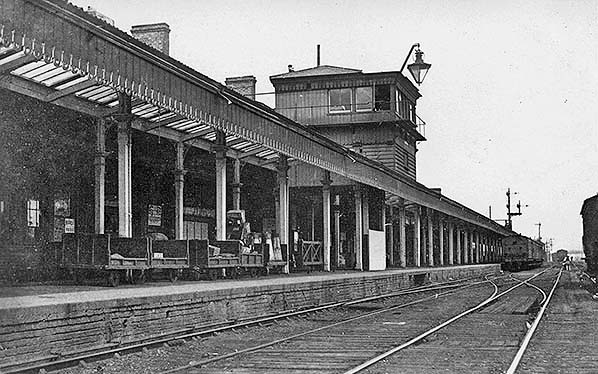
Above Cambridge Central signal box c1906 is seen. It was erected in 1885, equipped by Messrs Saxby & Farmer, and its purpose was to control the scissors crossing which was installed at the same time. Prior to 1885, control of trains using the bi-directional main platform was via awkward sets of points and signals at either end which in practice permitted only one service train to use the long platform at any one time. Central signal box also controlled the bracket signals seen above the train at the platform and a corresponding set behind the photographer. The scissors crossing allowed two trains to use the platform simultaneously but only if they were running in opposite directions. Signals permitting two trains at the platform with both running in the same direction were not installed until 1926. Central signal box was abolished in 1926 as part of the major resignalling of that year, but the scissors crossing remains to this day.
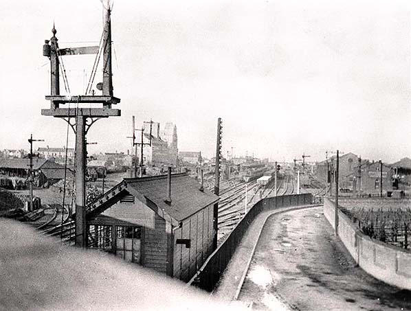
Above is a detail from one of the few surviving photographs showing Hills Road Junction signal box, equipped by Messrs Saxby & Farmer. One published source states this box dates from 1886 but company records make much earlier references to a Hills Road Junction box and is believed that seen above replaced an earlier and poorly sited signal box on the down side. The cattle market, partly visible on the right, had opened on 28 September 1885. Photographs of the original South signal box have proved elusive but it can just be seen above, partly hidden by the telegraph pole in the centre of the picture. It seems it was a narrow and cramped box which sat, like the original North boxes, directly in line with the end of the main platform. South signal box, like North, was also relocated during the 1926 resignalling but Hills Road Junction was abolished altogether. On the left Coote & Warren's coal yard can be seen and to the right of that what came to be known as 'Coalfields Sidings' (GER). There was also some GNR goods sidings to the left, out of view behind Coote & Warren's premises. On the right the GER goods shed can be seen and also part of the GNR shed. The GNR engine shed was out of view to the right. In the right foreground the cattle market can be seen; this dated from the 1880s. The roadway connected the goods sheds to Cherry Hinton Road and saw a constant procession of railway-owned or associated road vehicles right up until the late twentieth century. The fencing on the left of the roadway was later replaced with iron railings and this became the haunt of local railway fans for many decades. The coming of the GNR to Cambridge, with its awkwardly scattered goods and locomotive facilities, necessitated much alteration to Hills Road Junction and the signal box. Hills Road bridge itself, from which the above view is taken, was rebuilt in 1889/90 by John Mackay at a cost of £4149 9s 10d. The original 1845 bridge, a rather ornate brick arch structure, was wide enough for only two tracks. The replacement bridge was a box girder structure and this survived until replaced in the 1960s [BR records show that plans for this date back to 1950] by the present concrete beam structure; this was connected with a road widening scheme and, as is now standard practice, it was built with electrification in mind. It is Bridge No.1545. We will now move north to Mill Road as this location warrants rather more detail. It was mentioned in Part 1 that Mill Road originally crossed the railway by means of a level crossing. To anyone familiar with the hustle and bustle of Mill Road, a level crossing might seem rather absurd. It must be remembered that when the railway was built, the railway marked the point at which urban Cambridge stopped. East of the railway, today's Romsey Town, was then still rural and that section of what became Mill Road was nothing more than a track across the fields. The area along Mill Road west of the railway was - and still is - known as Petersfield. Once the railway arrived, housing was built mainly for railway workers in what today are the Great Eastern Street and Argyle Street areas. From then on, Romsey Town continued to spread eastwards as far as what are now Brooks Road, Perne Road and Burnside. Romsey earned itself a number of nicknames such as 'Red Town' and 'Little Russia' due to the large numbers of manual and apparently quite militant workers who settled there. Shops, schools, social clubs and so on sprang up and eventually motor buses served the area. The first motor bus route to serve Mill Road was Ortona service 2 which originally terminated at the junction of Mill Road and Malta Road. This was extended over time, eventually to St Thomas's Road and in 1931 had become service 102 under the Eastern Counties Omnibus Co. With Romsey Town having established itself, the Mill Road level crossing became a major nuisance. The problem was partly relieved by the construction of a footbridge; the first recorded mention of this being in August 1875 but the footbridge did not appear until the second half of 1879. The contractor was S. Hall & Co. and the cost was £130. Plans to replace the level crossing with a bridge first appeared in September 1888 when the wrought iron span was contracted to the Cleveland Bridge Co. for £1917. In December of the same year Messrs Holme & King were appointed general contractors at a cost of £3970 17s 9d. However, with everything else taken into account the final cost of removing the level crossing, providing the bridge, relocating the signal box [from the up side, south of Mill Road] and providing new signalling etc was £14,500. Signalling for Mill Road signal box had been quoted for in 1880 by Messrs Steven at a cost of £1273 12s 6d. However, it is not clear if this was related to the original Mill Road signal box or if it was a costing exercise in preparation for the building of the bridge. In the event, Messrs Saxby & Farmer provided the signalling, being contracted in late 1889.
Mill Road Junction signal box was abolished at an unconfirmed date but remained for many decades in use as a store and, apparently, messroom. It was demolished around the time the bridge was rebuilt prior to electrification. In the picture above, the signal box is sitting on what was once the roadway and off the picture to the right the foundry of Messrs Headly once stood. Immediately behind the tree on the right was the residence of Mr Headly himself; it was known as the 'ghost house' by local kids until its demolition. The shunt signal was controlled, electrically, from Cambridge North box post 1926 and a walkway can be seen on the side of the bridge to access signals mounted on the bridge, which is Bridge No.1546. The hut in the right foreground of the 1970 image above is of the type once commonly used for PW trolley storage and by the time of the photograph was in use as, it is thought, an oil store. The hut remained for a while after demolition of the signal box. The houses in the right background were railway cottages and received bomb damage during WWII. Water, to the cottages, was supplied by a well and a record survives from July 1873 stating the water was polluted and unfit to use. We do not know for certain but Headly's foundry, which stood directly opposite, may have been responsible. A water main was installed to replace the well.
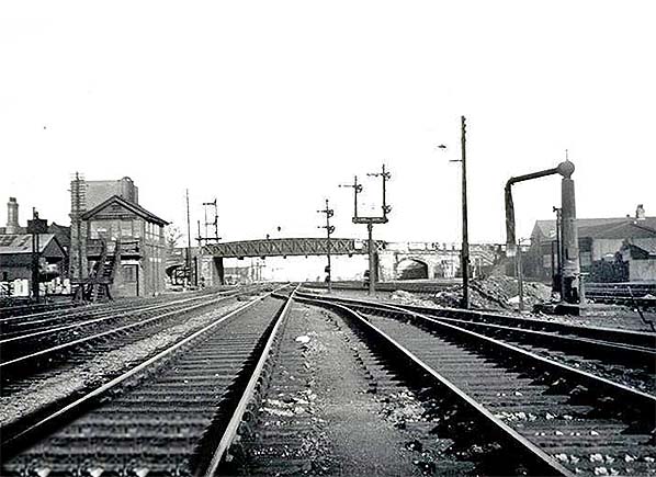
Above is a rather unusual view of Mill Road bridge, looking north c1948 - 50. The post 1926 Cambridge North signal box can be seen, as can the rarely photographed water tower which stood behind it. All signals in view are electrically operated and consist of upper and lower quadrant types. The signals just about visible mounted on the bridge were installed in 1926 while those in the centre of the image appear to be older GER types. The by-then-disused Mill Road Junction signal box is out of view behind the bridge. Note the water crane, used by pilot locomotives and those waiting to leave the down goods loop to its right. Engine sheds, goods sheds and yards
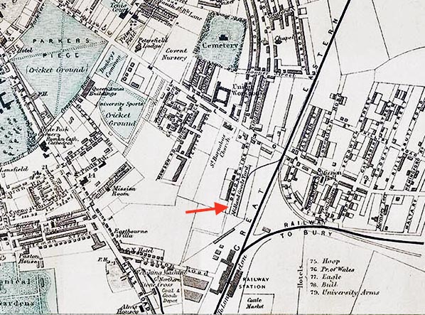
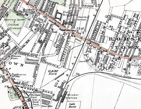
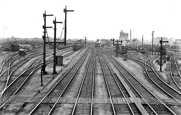
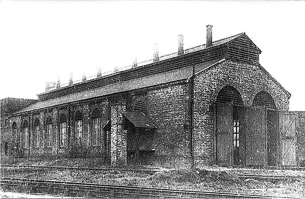
Note at bottom left the GNR goods and coal yard. The GNR also had a goods shed adjacent to its engine shed east of the railway. These maps show only an extremely basic track layout. The GER goods yard eventually occupied a large area of land between the cattle market and Argyle Street; this yard being for marshalling purposes only and had no public facilities. The GER public sidings were in the area so marked north-west of the station. This reason this as well as the Midland and GNR goods yards were shown was for the benefit of persons undertaking collections and deliveries. LNWR goods facilities are off the bottom left of the map. Above is a view looking south from Mill Road bridge in 1913. On the left the GER goods sidings can be seen; these actually comprised a marshalling yard where wagons belonging to all companies would be sorted. Over time and especially subsequent to the removal of the original Newmarket line, this yard became a dense network of sidings stretching east as far as what became Rustat Road. The LNER installed a hump facility with control tower, these being quite common in smaller yards but were never as well known as the more complex examples in bigger yards such as Whitemoor, Tinsley etc In the distance, left of centre, the GNR goods shed can just be seen while on the right the roads leading to the GER engine shed can be seen. Foster's mill dominates the skyline in the right background. We will now have a look at the GNR engine shed, located at the south end of the station and east of the line. Above the shed can be seen in August 1939. The road on the left snakes around the cattle market, alongside the railway adjacent to Hills Road bridge before turning east to join Cherry Hinton Road. Today it is a public road, Clifton Way. GER records tell us the GNR engine shed was built by Messrs Tracey at a cost of £500 - fairly cheap even for the time - and it was deemed ready for use in May 1869 although one source claims it did not open until 15 July 1879, but as GER records have survived it is difficult to contradict the date given The turntable was located to the right of the shed, on the road where an open wagon can just be seen behind the box van. The track seen swinging away on the extreme right is one of those which ran right through the GER yard and at one time connected to the original Newmarket line. It is the track on which 37114 is seen in the 1980 image below. There now follows something of a mystery. Also in May 1869 the GNR requested the GER install a 45ft turntable but there is no further record of this until as late as April 1890 when the GER transferred a 45ft turntable from Liverpool Street to Cambridge. The 1886 map shows a turntable already in situ at the GNR shed, so where the ex-Liverpool Street turntable was installed is not entirely clear as the GER and LNWR sheds already had turntables by that time. The shed is thought to have remained in use until 1924 after which it was used only for servicing until 1931 (these years are unconfirmed). It subsequently became a wagon repair shop and was finally demolished c1985, by which time it had been trackless for several years.
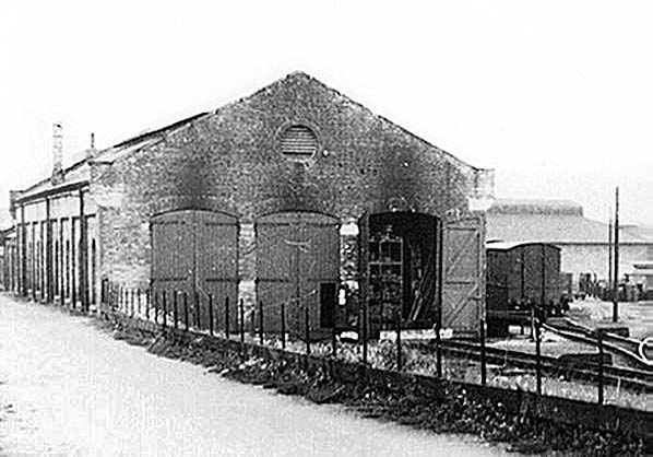
Moving to the south of Hills Road bridge and on the down side, we come to the LNWR engine shed. Technically a Bedford & Cambridge Railway building, it was used by the LNWR who operated the line from the outset and opened with the line in July 1862. Dates concerning the subsequent history of this shed vary but the general picture is that it closed as a shed during the 1931 - 35 period, was used for servicing until c1952 before being demolished in 1954. Certainly, photographs exist of locomotives stabled outside the shed during the early BR period. The tracks in the foreground lead to the LNWR/MR goods depot which very nearly became the LNWR passenger station. As this has already been covered in the earlier section on the arrival of the LNWR in Cambridge, details need not be repeated here. The other track, immediately beside the shed, served the turntable. The water tank can be seen at the rear of the shed and the structure on the side was probably a sand dryer. Immediately behind the water tank, albeit out of view, is Hills Road. Cambridge LNWR shed was a sub shed of Bletchley during its operational years; the latter being familiar as 1E, it was variously coded 4A and 2B at different times.
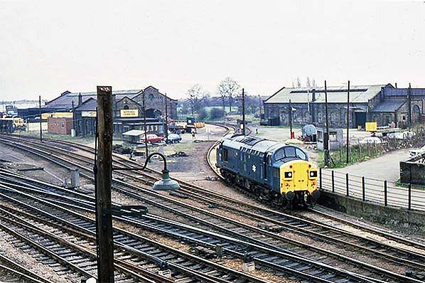
The first of the above two images was taken in July 1969 and shows the former GER goods shed on the right. Smoke staining from steam locomotives is still very evident above the rail entrance. The tracks of to the left lead to the former GNR goods yard (not to be confused with the GNR goods shed) and beyond those are what was known as 'Coalfields Sidings'. In the station, a Brush Type 2 and an English Electric Type 3 await departure for King's Cross and Liverpool Street respectively. In the second image, taken in March 1980, the GER goods shed has been demolished and this is the reason for using BR era images as we have a good view of the former GNR goods shed and engine shed, the latter being on the right. On the end wall of the goods shed the remains of the 'Great Northern Goods Depot' lettering (see below) can just be made out. In the left background of the image above the hump yard control tower can just be seen. This remained until c1985, by then derelict, when it was demolished along with the remaining sheds seen in this view. The locomotive is 37114 and the sand spread along the track will probably have dribbled from the Fen Drayton (St Ives) sand trains which proceeded from Cambridge to King's Cross. The track branching off to the right behind 37114 is that mentioned in the description of the GNR engine shed earlier.
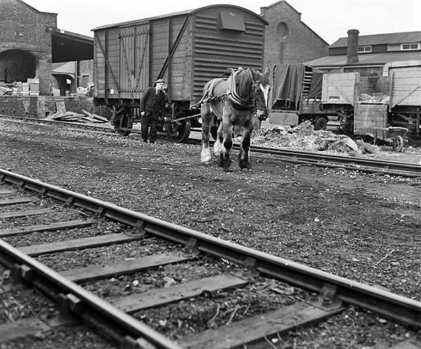
Above we see, horse shunting in progress at Cambridge in January 1957. The location is not immediately obvious; it is looking south with the GNR goods shed on the left and the GER goods shed on the right. The description with the photograph states the horse driver is Mr S. A. Plumb (Sidney Arthur Plumb) and that it is retirement day for Boxer, the horse. Tragically, just five months later on 8 May 1957 Mr Plumb, who lived on Akeman Street in the northwest of Cambridge, was to lose his life as the result on an accident in the down yard while three years previously another shunter, a Mr Hammond, had lost his life in an accident at Cambridge South. Click here to continue Part 2: The Pre-Grouping Period
|
 Today the track is much rationalised and electrified while, of course, the station is still there. Otherwise the scene has changed beyond recognition. On the left Cambridge Power Signal box currently stands (it is due, at the time of writing, to be abolished with signal control being from Romford) and the guided busway (or 'misguided busway' as many locals call it) runs alongside the railway to join the former Bedford line. The goods sheds have gone and the former cattle market is now a retail/hotel/cinema complex. Fosters mill in the form seen above is no more and the entire area to the west of the railway (the picture is looking north) is now covered by modern developments.
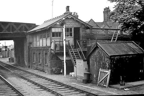
 An explanation of 'servicing' at otherwise closed sheds might be useful. As far as steam locomotives were concerned, servicing merely meant cleaning the fire, lubricating the motion, watering and coaling depending upon local arrangements in force and stabling between turns. Certainly, the LMS, if not the LNWR, encouraged coaling to be undertaken at the GER shed. In its later life, the LNWR shed was used mainly as a base for a standby locomotive and although an LMS locomotive was usually to be seen this was in fact an LNER duty.
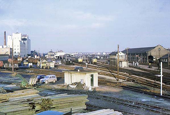

 Home Page