
Station Name: CHEVENING HALT [Source:
Nick Catford] 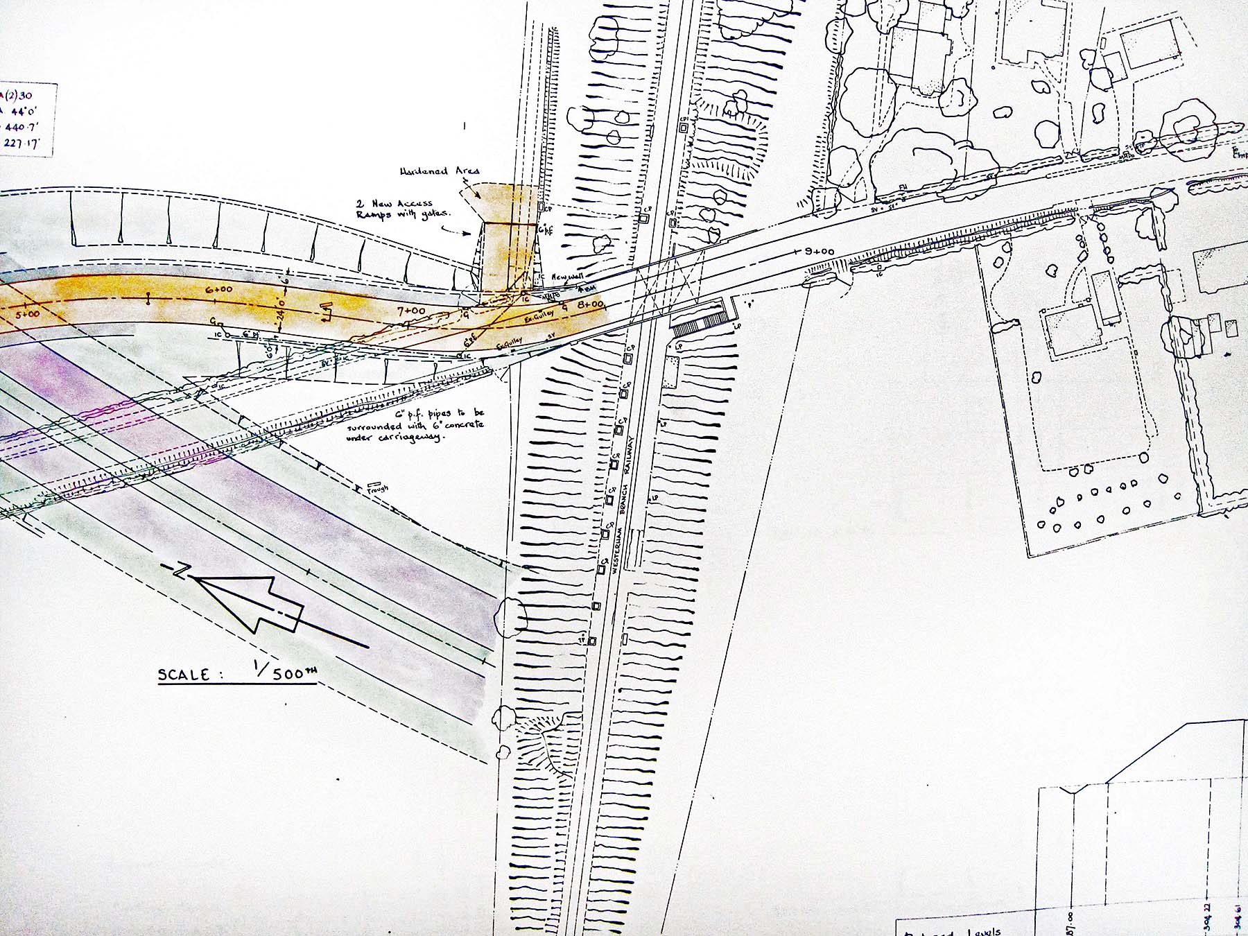
A detail from a plan showing proposed changes to the road layout in the vicinity of Chevening Halt. The halt, and most obviously its access steps adjacent the the bridge, can be seen in the centre. The railway ran due east - west, the plan being rotated to suit details of the proposed road changes. The road running south-west to north-east across the plan is the Chevening - Chipstead road and one of a few roads in the area known as Chevening Road. Where the road crosses the railway, the boxes with diagonal broken lines represent the bridge decks and that to the right was the never-to-be-used span allowing for doubling of the railway track. The dual carriageway at lower left is part of what was to become the A21 Sevenoaks Bypass. The broken lines of the coloured deviation to Chevening Road where it crosses the proposed bypass tell us Chevening Road was to cross the bypass on a bridge rather than pass beneath it. In the event, this deviation was never built and Chevening Road was raised to cross the bypass but remained on its original alignment. The 'Hardened Area' with access ramps would have been site access for contractors. Whether it be for road or railways, drainage is a very important factor and several references can be seen on the plan. Especially prominent are the CP markings in the railway cutting; CP standing for 'Cess Pool' which in simplified terms means 'drain'. The Sevenoaks Bypass opened in 1966 and this plan is believed to date from May 1963, after closure of the Westerham branch but before the track was lifted, the cutting and bridge being infilled immediately afterwards. The plan is concerned only with road changes in the vicinity of Chevening Halt, so the proposed Sevenoaks Bypass being shown as ending abruptly at the railway cutting is of no major significance although it may indicate the awaiting of the eventual outcome of the future of the Westerham branch. The bridge which would have been built, had the preservationists ultimately succeeded in their quest, was that for which the cost is usually quoted as being the reason for the failure of the preservation scheme. The plan long predates the M25 motorway. The M25, as it ultimately became, was born out of Sir Patrick Abercrombie's 'County of London' plan which included a series of 'ringways' around London. Sir Patrick's plan, which was to prove abortive, harked back to 1943 and the area around Chevening was to have been served by 'Ringway 4'; this 1963 plan includes a proposed junction with Ringway 4. Significantly, Sir Patrick's plan is said to have included the closure and taking over the routes of certain railway lines although it is not known if the Westerham branch was among them at that time. From the ashes of the London Ringway plan grew today's M25. However, the originally proposed route of the M25 in the Chevening area was on a different alignment to that ultimately constructed and probably because, at the time when plans for the motorway were still very much on the drawing board, the Westerham branch was still in existence in one form or another. What is now Junction 5 of the M25 as originally planned shows what was to be the M25 coming in from the west to merge with the A21 with the M26 diverging from the A21 a mile forther on. In the event, countless changes of plan resulted in the limited-access junction we have today.
 Home Page Home Page
|