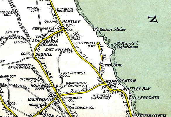
Notes: When the Blyth & Tyne Railway’s ‘Avenue Branch’ was opened between Hartley, Whitley / Monkseaton and Tynemouth (to goods in 1860 and passengers in 1861) it bypassed Seaton Sluice, and continued southwards, part of its length following the course of the old Whitley Waggonway, It was not until the early years of the 20th century when housing development seemed likely at Seaton Sluice that plans were devised by the North Eastern Railway to put the village officially on the railway map. Following electrification of the Newcastle – Whitley Bay ‘coast circle’ in 1904, a Bill to enable the construction of a branch from Monkseaton was deposited in the 1910-11 Parliamentary Session. It received the Royal Assent on 18 August 1911.
Collywell Bay station
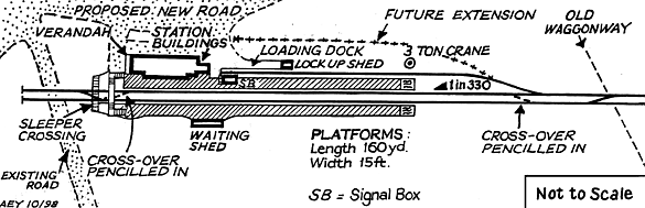
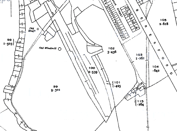
The station was at the terminus of the branch, 1 mile 68 chains from the junction with the Avenue Branch (Monkseaton – Hartley). It had two 160 yard platforms, the eastern one possibly intended to have a bay on its east side, as suggested by the accompanying plan. The station buildings and signal box were to be on this platform, with a waiting shed on the west platform. A footbridge was planned at the northern end of the station, as the tracks were to extend a little to the north of the platforms. The station was to be electrically lit.
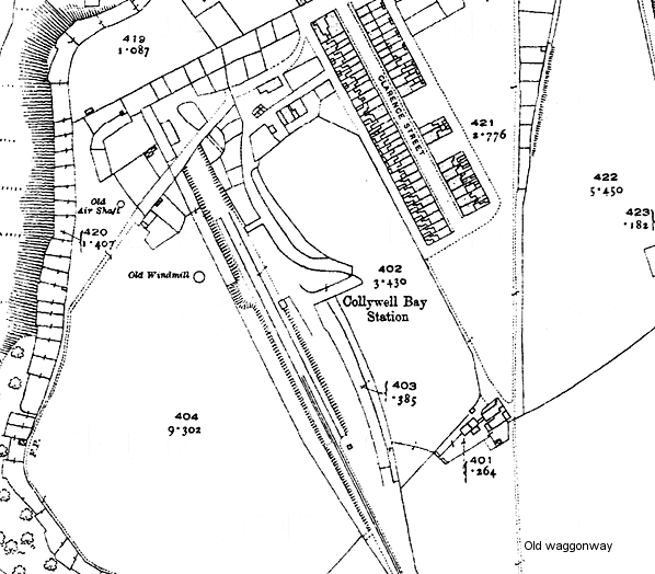
The Ordnance Survey 1: 2500 map of 1922 includes -and names - Collywell Bay station. The platforms and signal box are shown. The main building is not indicated, although its intended position can be deduced, and the widening of the west platform to accommodate the waiting shed is visible. A single railway track appears on the map, with a passing loop a short distance south of the station, and the line ends a short way along the west platform.
The platforms survived until at least 1964, at which time they were serving as a compound for livestock.
 |
THE COLLYWELL BAY BRANCH
A contract was agreed on 14 November 1912 with C M Skinner for an electrified branch line to Seaton Sluice, a little under two miles in length, leaving the Avenue Branch about a mile north of Monkseaton station. This section of the Avenue Branch would be doubled, and Monkseaton station would be rebuilt on a grand scale to accommodate the Seaton Sluice trains. It was decided not to call the terminus Seaton Sluice, but to use the more appealing name of Collywell Bay, considered more appropriate for an aspiring genteel resort and commuter destination. An intermediate station with a passing loop on the single track branch was to be provided at Brierdene, (A District Engineers’ map date-stamped 22 November 1913 named this station Delaval Bay.) At this station an attractive building was planned to serve the housing that was expected to develop around it. In May 1913 signed an Agreement with Lord Hastings permitting the NER to build the line across his land, of which he was to sell 21½ acres at £40 per acre. It was implied within the Agreement that at least 350 houses would be constructed near the terminus.
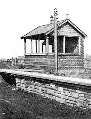 Signal box on the up platform Signal box on the up platform |
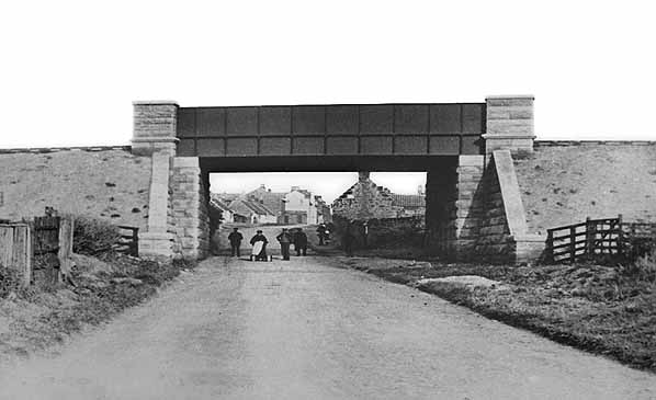
The NER expected to introduce the passenger service at the beginning of November 1914, and the name Collywell Bay was added to the destination blinds on the Tyneside electric stock. Construction was at an advanced stage when World War I broke out in August 1914, and the project was halted. A double line of permanent way was in place as well as the station platforms, bridges and signal boxes. A stretch of electric ‘third rail’ was laid at the Monkseaton end of the Avenue branch, the signal box at Brierdene Junction was constructed, and the new Monkseaton station was nearing completion: this station opened the following year. On the outbreak of war house building in the area ceased. In 1916 the Ministry of Munitions and Railway Executive Committee, faced with a shortage of essential materials, decided that new rails could be acquired by singling lightly used lines. In 1917 the rails of the Collywell Bay branch were therefore lifted. However a 1 mile 1,754 yard |
stretch of single line was restored using second-hand track (probably before the end of that year) to be used by a naval coastal defence gun, mounted on a specially built railway wagon.
 |
After the war the local council expected the line to be completed. The LNER reviewed the project in 1924 but did not proceed because little housing development had taken place at Seaton Sluice.
In November 1930 the cost of completing the project and operating a half-hourly passenger service and goods trains was weighed against the potential revenue, and the outcome was a decision to abandon it: its fate was sealed in an Agreement between the LNER and Lord Hastings on 1 December 1931. The line and bridges were removed by the end of 1932, but Lord Hastings permitted the partially built stations to remain in place because of the expense of their removal.
For many years the trackbed of the branch could be followed from Brierdene Junction. Only in the late 1950s did housing development at the Monkseaton and Seaton Sluice ends obliterate the line. Collywell Bay’s platforms were still intact amidst housing in 1964, but have since disappeared.
Sources:
- North Eastern lines and stations Bragg, S and Scarlett, E (NERA 1999)
- Seaton Sluice 1896 Godfrey Edition reprint (Northumberland Sheet 81.07). Includes historical survey by Alan Godfrey and the 1922 OS map on the reverse.
- Railways of the Northumberland coalfield Warn, C R (Frank Graham 1976)
- The Blyth & Tyne Railway (Three volumes) Wells, J A (Northumberland County Library 1989-91)
- Suburban railways of Tyneside Young, Alan (Martin Bairstow 1999)
- North Eastern Express North Eastern Railway Association Smith D R, Vol 36 No 145 February 1997, Fawcett, W Vol 36 No 147 August 1997, Dean, JC Vol 37 No 150 May 1998, Armstrong, Vol 38156 September 1999
I am grateful to J C Dean for commenting on this article and providing additional information.
Railway Clearing House (1914) map from Alan Young. Route map drawn by Alan Young.
See also: Brierdene & Seaton Sluice |

bay2.jpg)
bay3.jpg)
bay5.jpg) Collywell Bay station, looking north from the down platform in 1968. The former trackbed of the terminus is being used to accommodate a pony, with associated informal structures in corrugated iron and timber resembling a shanty town. The solid stone construction of the platforms is clearly visible. Had World War War I not commenced in summer 1914 the Monkseaton to Collywell Bay branch would have opened later in the year - and might even have survived to the present day as
Collywell Bay station, looking north from the down platform in 1968. The former trackbed of the terminus is being used to accommodate a pony, with associated informal structures in corrugated iron and timber resembling a shanty town. The solid stone construction of the platforms is clearly visible. Had World War War I not commenced in summer 1914 the Monkseaton to Collywell Bay branch would have opened later in the year - and might even have survived to the present day as.jpg)
bay1.jpg)

 Home Page