
Station Name: CRANLEY GARDENS15.jpg)
Looking east at the Cranley Gardens station up platform building c1962.
Photo from Ian Baker collection 23.jpg)
Cranley Gardens station looking west along the down platform c1962. The down platform building has recently been demolished.
Photo received from Malcolm Welstead 17.jpg) Cranley Gardens station looking east in July 1965. The station site is getting more overgrown and the surviving up platform building more dilapidated. Note the new fencing constructed across the track. The site was divided into two plots; that in front of the fence would be used for a school in the latter half of the 1960s.The far side of the fence would survive a little longer with a care home being built there in the early 1970s.
Photo by Jim Connor 8.jpg)
Looking east from the end of the platforms at Cranley Gardens station in November 1966. The street-level building on Muswell Hill Road is now in very poor condition and would soon be demolished along with the footbridge in front of the road bridge.
Photo
by Nick Catford
20.jpg) The condition of the up platform building deteriorated rapidly in the latter half of the 1960s. Contractors have started working in the goods yard behind the building. This view is from 1967.
Photo by Jim Connor 19.jpg)
In 1967 the street-level booking office on Muswell Hill had lost its slates and was awaiting demolition.
Photo by Ian Baker gardens1.jpg)
The passenger side of the Cranley Road booking office in August 1967.
Photo by Nick Catford gardens2.jpg)
Looking west along the down platform at Cranley Gardens station in August 1967 as construction of the new school is underway. The school building itself, seen to the left, is on the site of the goods yard.
Photo by Nick Catford gardens6.jpg) Looking west at Cranley Gardens station in April 1968. The up platform building has been demolished and the trackbed has been filled in on the far side of the fence as St James' Primary School is under construction. The remaining east end of the platforms would survive for a further two years. The school caretaker's house and adjacent brick tower, seen in the distance, are also visible in
the 2007 photo below. Photo by Nick Catford gardens5.jpg)
Looking east from Cranley Gardens station in April 1968 at the site of the recently demolished street level building and station footbridge.
Photo by Nick Catford 9.jpg)
Looking west from Cranley Gardens station in April 1970.
Photo by Peter Wright from Northern Heights web site 18.jpg) Looking east at the site of Cranley Gardens station in July 1972. The photographer is standing in St James' Primary School's playground which is on the west end of the station site. The building in front is the recently opened Cranwood Care Home which was on the east end of the station site. The houses in the background are on Muswell Hill Road. The care home closed in 2013.
Photo by John Mann gardens12.jpg)
Looking west from the Cranwood care home at St James' primary school which occupies the west end of the Cranley Gardens station site. (March 2007).
Photo
by Nick Catford
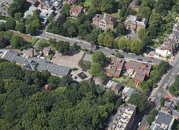
Recent aerial view showing the site of Cranley Gardens station. The bridge on Muswell Green Road is seen on the right. The surviving bridge parapet can be seen between the trees. The large brick building to the left of the bridge is the now-closed Cranwood Care Home which stands on the east end of the station side. To the left of that is the St James' Primary School. The playground and caretaker's house stands on the west side of the station site while the school building is on the west end of the goods yard.
|

 Home Page