
ETHELFLEDA BRIDGE, RUNCORN
|
| Date opened: | 1.2.1868 |
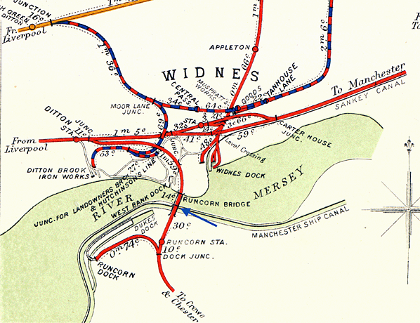
| Location: | Over the River Mersey at Runcorn Gap which lies between Widnes and Runcorn. |
| Company on opening: | London & North Western Railway |
| Date closed to passengers: | 1965 |
| Date closed completely: | 1965 |
| Company on closing: | Railways (London Midland Region) |
| Present state: | Footpath still extant |
| County: | Cheshire and Lancashire |
| OS Grid Ref: | SJ509835 |
| Date of visit: | 28.8.2009 |
Notes: The Ethelfleda Railway Bridge pedestrian footpath was situated on the 8.5 mile Ditton Junction to Weaver Junction line that was built by the London and North Western Railway (LNWR) and opened in its entirety on the 1st February 1869. The Bridge was located on the River Mersey at Runcorn Gap, which separated the Counties of Cheshire and Lancashire. The most formidable obstacle along the route of the Ditton Junction to Weaver Junction line was the River Mersey. The shortest crossing point was at Runcorn Gap, which lay between Widnes in Lancashire and Runcorn in Cheshire. A further complication was the fact that the admiralty insisted on a 75 feet clearance beneath any bridge structure so that the largest naval vessels of the day could pass underneath. Powers had been granted to Grand Junction Railway as early as 1846 to construct a line from Ditton to the Grand Junction’s Warrington and Birmingham Railway at a point just north of the River Weaver in Cheshire. The powers granted had included the construction of a bridge at Runcorn Gap. The reason for constructing the line was to cut journey times between London and Liverpool. To access Liverpool trains had to cross the Mersey at Warrington via the original 1830 Liverpool and Manchester Railway which added considerable time to journeys. The Grand Junction Railway was given seven years to build the Ditton to Weaver Junction Line a timetable that it did not meet. By 1861 the Grand Junction Railway had become part of the LNWR and the new company resurrected the original proposal. They secured Parliamentary approval in 1861.
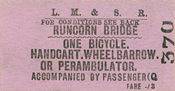
The bridge was named after Ethelfleda the Queen of the Mercians (870s to 918) who had associations with Runcorn where her kingdom’s most northerly border was at Runcorn. Indeed it was a visit to Runcorn by Ethelfleda that gives the town its first recorded mention. Fortifications dating to the time of Ethelfleda were discovered at Runcorn and this gave the LNWR the idea of building the bridges sandstone support pillars in a castellated style. The LNWR also decorated the bridge with the City of London Coat of Arms, a shield bearing an image of Britannia, their own LNWR crest and a shield bearing an image of the Liverpool Liver Bird. Because of the image of Britannia the bridge is sometimes called the Britannia Bridge. By November 1866 the abutments were completed and the first two girders had been set into position on the Cheshire side. The sixth and final girder was put into place on the 14th February 1868. A test train passed over the bridge on the 21st May 1868. It was a great occasion and 500 people travelled on the train. The bridge opened officially to goods trains on the 1st February 1869 and to passenger train services on the 1st April 1869. It is likely that the footpath opened to pedestrians on the 1st February 1869. Persons using the bridge would have accessed it from Viaduct Street on the Widnes side or Lord Street on the Runcorn side. Originally a ticket booth was located on both sides of the River Mersey. On the Widnes side of the bridge it was adjacent to Viaduct Street and it consisted of a simple wooden structure that provided basic shelter for the ticket seller. On the Runcorn side the booth was located in Lord Street at the bottom of the access steps that led up to the bridge. It was also a wooden structure. In later years tickets were only sold on the Widnes side. Persons wishing to cross from Widnes to Runcorn purchased their tickets before they went onto the footpath but people coming in the other direction paid their fare after they had already crossed the bridge. On the Widnes side the footpath climbed up to the same level as the railway line by means of a slope set into an embankment. At the top of the embankment the footpath moved onto a supported walkway paved in stone, which was attached to the approach viaduct on its east side. A wall divided the footpath from the railway tracks. The supported footway led onto the actual bridge. It passed through each of the support pillars via a castle style doorway. The footpath was on the outside of the girder spans again on the east side of the bridge. At this point the footpath surface was of timber construction. From the Runcorn side the footpath climbed up to the same level as the railway line by means of stone steps located on four archways from the start of the girder spans. From the first day of opening the footpath was used by hundreds of people every day who each paid one penny. This seriously affected the ferry service, which by this time was also owned by the LNWR. After the opening of the bridge was mostly used for local goods and the movement of livestock. During the early 1890s the ferry was disrupted by the construction of the Manchester Ship Canal. The LNWR stopped operating services, which led to complaints from the Widnes Corporation. In 1893 the Manchester Ship Canal opened. It passed through Runcorn Gap and was separated from the river by a huge stone wall. This meant that there would have to be two ferries. One for the river and one for the canal. Passengers would have to climb over the wall to change between the canal and river ferries. By January 1895 the LNWR had still not re-introduced the ferry and it took legal action by the Widnes Corporation, supported by Runcorn Urban District Council to get it reinstated. All of this drove even more foot traffic onto the railway bridge. In 1905 a transporter bridge was opened on the east side of the Ethelfeda Bridge. The Transporter bridge, which consisted of a mobile platform slung under an iron girder structure that spanned the river, was constructed so that road traffic and pedestrians could cross the river. Initially the LNWR had opposed the Transporter Bridge but when they got an agreement that would allow them to discontinue the ferry service they withdrew their objection. Although the Transporter Bridge proved to be most convenient for road vehicles it was quite slow and pedestrians continued to favour the Ethelfeda footpath as a means of crossing the river. In 1923 the Ethelfeda Bridge became part of the London Midland Scottish Railway company. During the Second World War a sentry was posted on each side of the bridge. The sentries checked each person who crossed the bridge to ensure that no saboteurs accessed the bridge which carried such a vitally important railway link between Liverpool and the South. In 1948 the bridge passed into the ownership of British Railways (London Midland Region). By the 1950s increases in road traffic had resulted in lengthy queues to use the Transporter Bridge becoming commonplace. A better solution had to be found. The Lancashire and Cheshire County Council’s drew up plans for a road fixed bridge. Work commenced on a new suspended deck arch bridge on the 25th April 1956, it was of a type similar to that built across Sydney Harbour in Australia. During the construction of the road bridge the Ethelfleda Bridge footpath became busier than ever as many people used it as a vantage point to view the construction site. The new road bridge was provided with pedestrian footpaths that would be free to use. The new bridge opened on the 21st July 1961. Because of this tolls for using the footpath were been withdrawn in 1962 and staff, who manned the booth, were taken away from the bridge. Even though the new road bridge was available for the public to use people continued to use the railway bridge footpath. A census taken in July 1962, only one year after the opening of the road bridge, between 9.00 a.m. and 9.30 p.m recorded 152 pedestrians using the railway bridge footpath from Widnes to Runcorn and 70 in the reverse direction. The Transporter Bridge closed on the day after the new road bridge opened on 22nd July 1961 and was demolished shortly after, to the dismay of local people. Without a staff presence problems occurred on the Ethelfleda Bridge footpath including the throwing of stones and bottles by youths which caused a great deal of annoyance to householders in the West Bank district of Widnes. British Railways were very keen to close the footpath and they did this through legal process which was contained in the British Railways Act of 1965.
|
bridge_old3.jpg)
Photo from Pete Blackmore collection
bridge_old5.jpg)
Photo copyright Halton Borough Council - reproduced with permission
bridge_old10.jpg)
LNWR postcard from Pete Blackmore collection
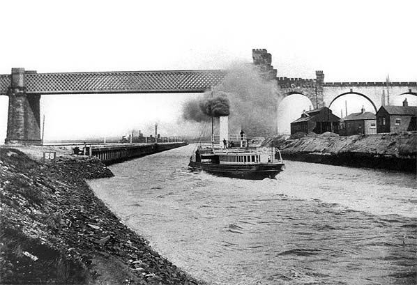
Looking east towards Ethelfleda bridge from the Manchester Ship Canal in the 1890s.
Photo from K James
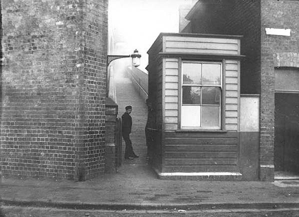
Photo from Pete Blackmore collection
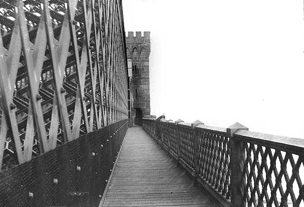
Photo from Pete Blackmore collection
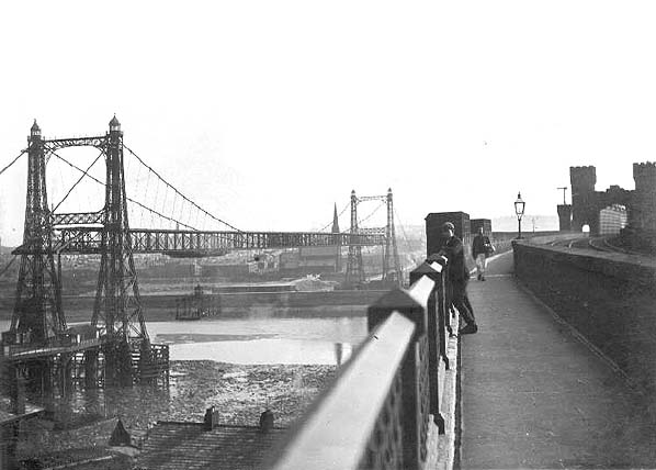
Photo from Pete Blackmore collection
bridge_old9.jpg)
Photo from Pete Blackmore collection
bridge_old12.jpg)
Photo from Pete Blackmore collection
bridge8.jpg)
Photo by Paul Wright
bridge11.jpg)
Photo by Paul Wright

 Home Page
| Last updated: Thursday, 18-May-2017 11:17:27 CEST |
© 1998-2009 Disused Stations
|