[Source: Darren Kitson]
The English County of Kent sits between the English Channel and Straits of Dover to the south and east and the River Thames to the north while merging seamlessly into London at its north-western corner. The geological features of the county run east - west and mainly comprise the North Downs, a chalk escarpment, and the Weald. The South Downs, a similar chalk escarpment, lies predominantly in what are today the neighbouring counties of East and West Sussex while the Weald also reaches west into Sussex. The term 'weald' means woodland and the 'Wealden Dome', to use the geological term, was formed millions of years ago by movements in far away mountain ranges. These ranges are what we know today as The Alps. The geology of the Weald which, as the name suggests, was once heavily forested, comprised an upper layer of chalk beneath which were layers of Upper Greensand, Gault Clay, Lower Greensand, Weald Clay and Wealden Sandstone. Certain of these layers eroded faster than others and over millions of years erosion created the ridged landscape of Kent with which were are familiar today.
Chalk, or Calcium Carbonate, is a form of limestone created over millions of years from the skeletal remains of countless billions of microscopic aquatic organisms and it is for this reason chalk is largely found in coastal regions and inland regions which were once much closer to the coast if not beneath the sea. An example of this is the area north of the Thames where rolling chalklands stretch from Suffolk and Essex through South Cambridgeshire and Hertfordshire towards the Chilterns. The area with which we are concerned here, around Dunton Green, is penetrated by the River Darent which rises near Westerham before heading towards Sevenoaks and then northward to meet the River Cray and ultimately the Thames. The river deposited gravel was available to extract.
Kent is more usually associated with hop growing, oast houses, fruit growing, Canterbury Cathedral, coal mining to a perhaps lesser degree and some of the quaint railways managed by the late Colonel H F Stephens. Not so well known is that Kent once had, indeed still does on a much smaller scale, a number of other industries including cement works, brickworks, lime kilns often in combinations of all three at the same sites.
Younger readers may be surprised to learn that Britain, with her one-time Empire, was a major manufacturing and exporting nation. Imports were once restricted virtually to what could not be mined or grown at home: certain metals, gemstones, wood, fruit and vegetables namely. Otherwise Britain was quite self-sufficient in her requirements and apart from the giant industrial concerns scattered across the country but more usually associated with the Midlands, North-West and North-East, there were once countless small industries attached to smaller towns and even villages. Very often these industries were created by, and on the land owned by, local gentry who had requirements and responsibilities extending far beyond merely keeping the lawns and hedges of their mansions looking smart.
In the days before railways and road motor transport, incoming raw materials, which were not locally available, and end products relied upon the horse and cart or water transport. This was a slow and extremely costly so prior to the nineteenth century industries were based on local resources. To a limited degree this remains the case today but, as already mentioned, British manufacturing is now a mere shadow of its former self and where it does still exist on a large scale it is in all likelihood under the control of foreign owners.
The geology of Kent, as briefly described earlier, made Dunton Green a suitable location for just such a local industry - the Brick, Tile & Pottery Works. It was one of countless similar industries which were dotted around not just Kent but across the country at locations where the ground yielded the requisite raw materials.
Clay-based industries had existed at Dunton Green since the sixteenth century at least but the major turning point came in 1862 when authorisation was given for the railway to be constructed through Dunton Green. In that same year William Thompson, a London tea merchant who resided at nearby Sevenoaks, created the Brick, Tile & Pottery Works. In this case the connection with previously mentioned local gentry was Samuel Wreford, a silk merchant, who was Lord of the Manor at Dunton Green and thus the major landowner in the area. The Wreford family resided at Broughton House, London Road; a large house set in its own parkland and which still exists today although the Wreford family have long since vacated. This family was responsible for the name of the railway siding known as Wreford's Siding, which was originally the connection to the works but outlived it by many years. The apparent haste with which the brickworks was constructed, six years prior to the railway opening, is thought to have been due to Thompson hoping for business supplying bricks and other products to John Jay, the contractor who ultimately constructed the SER through Dunton Green. Whether this anticipated business materialised is unconfirmed.
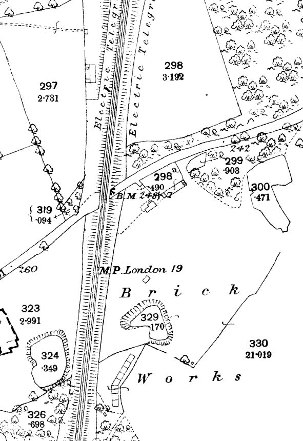
This 1872 1:2500 map shows the brickworks site in its fledgling state. It was later to expand considerably. The railway had opened four years previously and the connection to the works known as Wreford's Siding is not shown. This is not proof that the siding did not exist at this time as early maps often omitted such details. A number of details are worth mentioning. The road running diagonally across the map is Rye Lane and to the right of the bridge is the Railway Tavern. The plan of this building differs to that shown on later maps and indeed differs to the photograph of the tavern shown in the ‘Disused Stations’ Dunton Green pages. It is for this reason that the building is thought to have possibly pre-dated its use as a tavern and the photograph, albeit poor quality and taken at a later date, shows no evidence of structural alterations. Milepost 19 from London is also marked but, assuming 19 miles to be accurate, it is unclear where this distance was measured from. Dunton Green station is sited at the very top of the map, i.e. a few chains closer to London, but today from either Charing Cross or Cannon Street the mileage to Dunton Green station exceeds 19 irrespective of route. Proudly announced on the map is the provision, on the railway, of the electric telegraph. This was the forerunner of the railway telephone system and communication was via a coded system similar in principle to Morse Code. In essence, the electric telegraph survives today albeit rapidly disappearing, other than on heritage railways, in the form of bell codes between traditional signal boxes.
Quite who owned the works at various times is not entirely clear. It is not unreasonable to suggest the works, or the land it occupied, continued to be owned by the Wreford family but was leased or rented. The number of owners and / or managers over the fairly short life of the works suggests that the works was not as profitable as had been hoped. Profitability – or financial constraint -, may explain the rather frugal purchase of the Aveling & Porter locomotive which we will come to later.
In 1881, a few months prior to the opening of the Westerham branch, Thompson vanishes from the scene and ownership of the works comes under John Hooker and the name became 'The Dunton Green, Sevenoaks, Brick, Tile & Pottery Works'. The inclusion of Sevenoaks in the title was probably to put the works more 'on the map' to encourage more business which, in turn, may imply that profits were falling short of expectations.
Charles Chambers, the Westminster-based contractor who constructed the Westerham branch, put equipment up for auction at Brasted and Dunton Green in November 1881. Among this equipment were the locomotives, or two of them, which had been used during construction. One is said to have been a Hunslet 0-6-0T, identity unknown, and the other a Manning Wardle D class 0-4-0T named 'Westerham'. The latter is believed to have been works number 718 and new in September 1880. The distinctive locomotives of Messrs Manning Wardle, in either 0-4-0T or 0-6-0T form, were a popular choice with contractors and several photographs of them survive engaged on various contracts across the country.
Although it should be made clear that absolutely no proof has been found, it is possible that Hooker bid for either or both of the contractor's locomotives. If he did he was obviously unsuccessful, again this perhaps suggesting that the works was not as profitable as had been hoped, for it was early in 1882 that the Aveling & Porter locomotive appeared; Hooker being invoiced for the locomotive during March of that year. Whilst much of the aforementioned concerning the contractor's locomotives is vague, to say the least, the arrival of the Aveling & Porter tells us that by 1881 the works was rail-connected and, more to the point, had an internal standard gauge system either planned or already in existence.
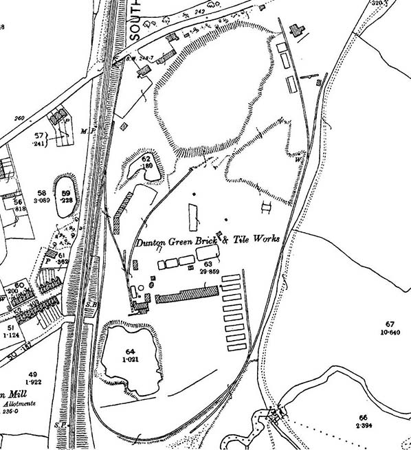
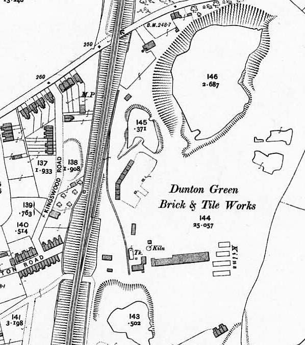
This 1896 1:2500 map shows, relative to 1872, the much expanded brickworks site. Adjacent to the down SER main line the connection known as Wreford's Siding can be seen and from that the reverse connection to the works' internal system. The internal system was rather 'bitty' with the Y- shaped section in the middle of the site and another line, with sidings, swinging round the south of the site before turning northwards along the eastern side of the quarries. Seemingly impractical track layouts such as this were common at such sites as quarrying drifted, new quarries were opened and fixed facilities were expanded. At bottom right the River Darent can be seen. It is not known if the short siding nearby was anything to do with the river. The Darent rises near Westerham and passes through the Sevenoaks suburb of Riverhead before meandering northwards to meet the River Cray near Dartford and then the Thames. The name Riverhead is nothing to do with the source of the Darent and is thought to mean 'cattle landing place'. Note there was once signal box controlling Wreford's Siding. This was removed and replaced with a ground frame when much of the brickworks' internal system was removed in the first decade of the twentieth century. The ground frame was known as 'Wreford's Siding GF' so logic says the signal box was also known as Wreford's Siding, but no information on this box has been found.
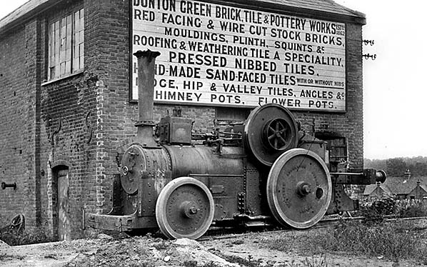
The large sign, which would have been hand-painted on wood, leaves no necessity to explain the location of this view. Note that the title of the works does not include Sevenoaks, this addition being made after Hooker took over the works in 1881. This photograph poses a number of problems as the result of being undated. The internal standard gauge system had been dismantled during the first decade of the twentieth century and the staff cottages, right background, appeared sometime after 1896 but before 1909. One source implies that the cottages, which stood on Pounsley Road, were erected when Owen Breething took over the works - in other words, in 1904. The Aveling & Porter locomotive, which is described in the text, is said to have survived until 1927 notwithstanding the internal system being dismantled some two decades previously. Thus with just these few pieces of the jigsaw we know that the photograph was taken after 1896 but before 1927 and possibly in 1904. The locomotive appears semi-derelict but this was almost normal for environments such as this. However, the wheel flanges appear polished suggesting that the locomotive was still in use. The pulley attached to the flywheel was used to drive, via a flat belt, a clay crusher so it is possible that the locomotive continued to be used for this purpose after the internal system was dismantled, with just a short length of track retained. The system does not appear to have had a locomotive shed and the purpose of the building seen above is not known although it bears the hallmarks of having contained a stationary engine of one form or another and the locomotive sits on what looks like a staithe.
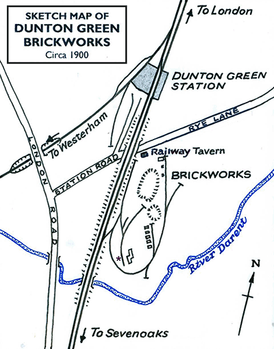 This map (left) is intended to show what is believed to have been the location of the Aveling & Porter locomotive when photographed, marked by the asterisk towards the bottom of the brickworks site. The Railway Tavern is also marked, to the south of Rye Lane. The road parallel to the main line and leading from Station Road is the Station Approach. This map is not to scale; please refer to the 1896 OS map for a more accurate representation of track layout and buildings, especially within the brickworks.
Around the time Hooker appeared, the works was managed by Ebenezer Breething and Ebenezer's son, Owen, became the owner of the site in 1904. It was under the Breething jurisdiction that the internal standard gauge rail system was removed and these people may have been responsible for dropping 'Sevenoaks' from the title, but it should be remembered that the sign in the above image may have been original and never altered to accommodate the change of title.
The locomotive at Dunton Green was one of the strange machines built by Messrs Aveling & Porter of Rochester, a firm better known for their steam traction engines and road rollers. They built a substantial number of these locomotives, to several gauges, which were in effect traction engines on rails. They were cheap to build, cheap to operate and could be driven by anybody with prior knowledge of traction engines and some basic railway training. The similarity to traction engines is obvious; cylinder and valve gear above the boiler, large flywheel and underslung water tank. These machines could be found in brickworks, quarries, cement works and so on. Two even worked passenger trains on the Wotton Tramway (better known as the Brill branch) and at least one of these is known to have been adapted from a traction engine during the construction stage. Cheapness was all well and good but these locomotives produced only a rather dire 8 - 10hp and could manage a speed only in the region of 10mph. While all this may seem mildly comical it was just about adequate for the work intended of them which was slow speed shunting of two or three small wagons on less than perfect track. They were intended as an economical replacement for horses where the cost of a 'proper' locomotive could not be justified and in most cases, including on the Wotton Tramway, this is precisely what they did - albeit slowly.
The locomotive pictured above is said to have been Aveling & Porter works number 1740 of 1882. It was based upon a type of contraption introduced in 1872 (some sources say 1871) for the Royal Engineers and known as 'Steam Sappers'. Of 2-2-0 wheel arrangement, driving wheels were 5ft diameter and the front, unpowered, wheels 3ft 6in diameter. Wheels were one-piece castings. Other Aveling & Porter locomotives had equal wheels with spokes, basic cabs and more locomotive-like chimneys and these were of the 0-4-0 type. One, at least, of the Wotton Tramway locomotives was an 0-4-0 and used an enormous exposed roller chain. Some equal wheel variants had what looked like coupling rods but they were in fact equalising beams mounted between axles. Most if not all were of the Well Tank arrangement with the water tank slung beneath the boiler as on the Dunton Green locomotive.
Of note on the Dunton Green locomotive are the rear buffers set at standard wagon height (this gives an idea of the diminutive size of these locomotives) and the front beam set much lower, presumably to conform with some form of internal-user wagon. There also appears to be a crude link and pin type coupling but the front bufferbeam for standard size wagons was actually missing. This is hardly surprising as clearly it would have made access to the smokebox rather awkward. The precise specification was ‘2 extra bufferbeams for small waggons with 4 sets draft chains, beams 6ft 2in x 5¾in x 9in. 2 buffer blocks fitted to beams 6in x 6in x in and 2 ditto 16in x 19in x 9in’. Later examples with a normal height front bufferbeam had a modified smokebox door to alleviate the problem. A potted history of Aveling & Porter, plus the comical story of experiments which led to the 'Steam Sappers', can be read here. On the same page can also be found pictures of other Aveling & Porter locomotives plus tractions engines and road rollers, from which parentage the Dunton Green locomotive is very obvious.
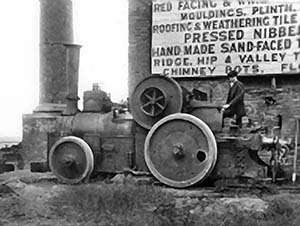 Careful examination of the locomotive's position suggests that this view of the Aveling & Porter was taken at the same time as the previous view. The different camera angle compared to the previous view reveals the two, at least, chimneys which stood on the north side of what is thought to have been an engine house (not an engine shed). The young man standing on the scuttle is merely posing for the camera. He is not at the driving position and in any event the locomotive is not in steam. The hole in the driving wheel is not the result of a mishap; it was made at the construction stage to ensure that the wheel was perfectly balanced, and a similar hole would have found in the other driving wheel. Wheels were one-piece castings without separate tyres.
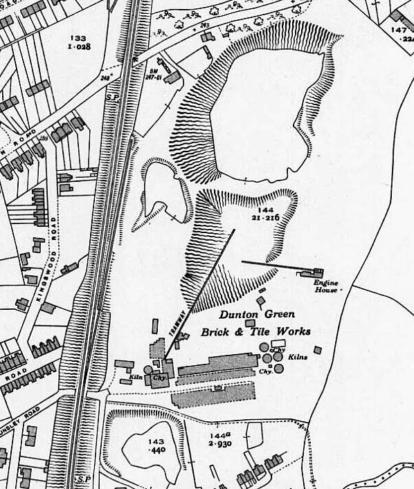
This 1:2500 map from 1909 shows the extent of the internal standard gauge rail system after much of it had been dismantled during the first decade of the twentieth century under Breething's auspices. A number of changes are apparent to the cluster of buildings where the locomotive is believed to have been photographed. Wreford's Siding signal box, assuming this to have been its name, has also vanished. Wreford's Siding itself can be seen descending to a lower level beside the SE&CR main line with its headshunt reaching north almost to the Railway Tavern. At the bottom of the map the four cottages provided for brickworks staff on Pounsley Road can be seen. A narrow gauge railway system continued to exist within the works, but as these were of a temporary nature and moved around as requirements dictated they were seldom shown on maps.
The Dunton Green Brick, Tile & Pottery Works was by no means the only such operation in the area. Others existed in and around Sevenoaks and along the Darent Valley towards Bat & Ball station, to which location a tramway once paralleled the railway. For readers unfamiliar with the area, the railway via Otford and Bat & Ball was the first route to serve Sevenoaks from London and is a different route to that via Dunton Green. The two routes merge immediately north of Sevenoaks station (once known as Tubs Hill). The delightfully named Bat & Ball is Sevenoaks' second station, named after an inn which has long since vanished. Originally named Sevenoaks Bat & Ball, it was renamed, simply, Bat & Ball in 1950. Originally the terminus of a branch from Swanley, Sevenoaks Bat & Ball opened in 1862 and thus predated the route via Dunton Green by six years. At the time of writing the route via Bat & Ball is mainly served by Thameslink services while SouthEastern operates services via Dunton Green.
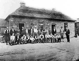 This view of Dunton Green brickworks and likely in the 1925-38 period when most photographs of the works in operation were taken. The subjects appear to be a mix of manual workers and clerical staff, some perhaps being foremen. The gentleman standing on the right would have been a manager, perhaps a member of the Breething family, his out-of-line position being typical for more senior people in photographs like this. The building and its location cannot be identified. Possibly it was offices which would have been located among the buildings near to the south side of Rye Lane.
Some of the brickworks in the area did not survive into the twentieth century. As was the case across the country, all such works supplying the construction industry were dependent upon a buoyant national economy and at times of depression or recession the construction industry ground almost to a halt. Indeed this is still, and always will be, the case and affects many branches of industry. This in turn sent many small brickworks to the wall. The same happened with countless small cement works which were once dotted across the country. The days when governments created construction projects to relieve the resulting unemployment are now largely just a chapter in history. In the Sevenoaks area one of the first brickyards to fail was St John's, located at what is now the Vestry Estate off the Otford Road. This was the works which operated the tramway to Bat & Ball station. It closed in 1897, but not before a boiler explosion in 1876 killed two men and injured 14 others. Other works closed down in the inter-war years, largely as a result of the Depression.
Depression and national economy aside, some failures of brickworks, cement works and so forth were simply down to a saturated market and in some ways not dissimilar to the negative effects of the so-called Railway Mania of the nineteenth century which saw countless financial disasters. Nevertheless, as many brickworks across the country fired their last bricks others managed to survive and seemingly against all odds. One such was the Dunton Green Brick, Tile & Pottery Works.
This map shows the situation at Dunton Green in 1941 during the Second World War. When compared to the 1896 map shown earlier a number of changes are apparent with the addition and removal of various buildings being the most obvious. Wreford's Siding is now just a single length of track from the main line, while a tramway is shown entering the quarry. It commences at what is thought to have been an engine house and descends into the quarry. At centre right another engine house has appeared but what it powered is unclear; the line marked between it and the quarry is not marked 'tramway' so could have been a conveyor system.
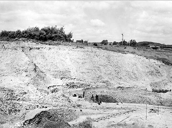
A view of the clay pit, which proved to be rich in fossils, at Dunton Green brickworks in 1931. Information with the photograph states that the location was half a mile north of Riverhead (now a northern suburb of Sevenoaks) and the camera is looking west. However, the railway bridge in the right background appears to be that on Maidstone Road; if so, the camera angle is rather different from that stated. In the centre background what appears to be an engine house can be seen. Not especially obvious in this black-and-white view is the division between Lower and Upper Gault roughly two-thirds of the way up the pit face. Some narrow gauge tracks can be seen on the pit floor. Probably of 2ft gauge (actually 1ft 11½in or 60cm), these were of a temporary nature and would be moved around as required.
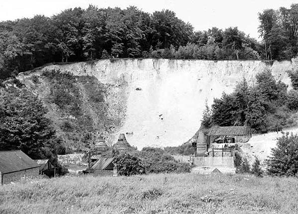
Dunton Green Lime Works pit, seen here in June 1931. This was some distance from the brickworks proper, about one mile north of Dunton Green and near the crest of the North Downs scarp face. The exposed face is Middle Chalk with lines of flints occurring near the top of the face. Three lime kilns are visible and there were likely to have been others. Those visible are of the 'shaft' or 'bottle' type. None of those visible appear to be in operation; they could well have been out of use by this time, either replaced with more efficient plant or redundant owing to the large scale switch from Quicklime (the end product of these kilns) to Portland Cement in the construction industry. See text.
Lime kilns produced quicklime through a process involving the burning of calcium carbonate, in other words limestone and specifically chalk which is a type of limestone. The type of kiln seen in the June 1931 photograph contained a heat source, usually coal, coal and wood or coke, and chalk was loaded on top of this. As the chalk burned, the end product was retrieved from the bottom of the kiln. The process could, depending upon kiln design, involve one-off firings after each of which the process was repeated or it could be a continuous process along the lines of 'in at the top, out at the bottom'. While the theory was simple, the process was slow with earlier designs of kiln taking several days to produce the end product, and skill was required to load the kilns and get the timing of the process correct.
Quicklime (Calcium Oxide), the end product, is a solid white material with quite unpleasant properties - it burns the skin and especially if moisture is also present. As a result it has at various times in history been used in sinister situations. The Nazis, for example, sprinkled it onto the floors of the freight wagons of the 'Resettlement Trains' transporting victims to the death camps situated in occupied Poland. During these journeys, which could last days or weeks, the victims had no choice but to urinate and defecate in the freight wagons (this was the actual reason for the sprinkling of quicklime in the wagons). The result was burned skin but this, of course, was nothing compared to what awaited them at the destinations. Quicklime has also been used in mass graves and in the graves of individual murders in an attempt to destroy the remains. There are of course a number of benign uses for quicklime, the best known being lime mortar. This is a type of mortar (cement) created by mixing quicklime and, usually, sand. Largely now superseded by Portland Cement, lime mortar was especially suitable for buildings constructed of stone and other porous materials. For this reason it is still produced today, occasionally for new builds using traditional materials but more usually for repair and restoration work on historic buildings where authenticity is required. Sand-Lime bricks were and still are also produced. Production is today accomplished by modern, efficient plant often using rotary kilns similar to those used at cement works. The lime kilns of old, in their various forms, are now considered industrial archaeology and their remains, in various states of completeness or dereliction, remain a common sight around the country wherever chalk can be found.
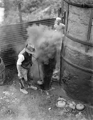 Right we see the bottom of one of Dunton Green's lime kilns in 1938 - the point where the end product was removed from the kiln. The purpose of the circular objects on the ground is unconfirmed but possibly they were used to pound, and thus break up, the lumps of lime as they left the kiln. The work of the men was hazardous as the above view suggests, not least because of the dust from the lime which was, to put it in simple terms, nasty stuff. The job was also erratic as lime kilns were problematic to operate in seriously wet weather and the men were paid only for time worked; in other words, if rain stopped work the men did not get paid. More modern mechanised plant eventually saw an end to these problems.
The following three photographs are included as they show the gravel workings at Dunton Green. However, precisely what the relationship to the brick and tile works was, if any, has proved difficult to determine. The location was west of the railway (the main line) and London Road and to the north of Riverhead adjacent to the north side of the River Darent. Subsequent to the following three photographs being taken, the site expanded westwards towards Chevening. Latterly operated by Tarmac Group, the location is today known as Chipstead Lake.
This May 1937 view looking north-east shows gravel working in River Darent alluvium. Gravel is being loaded into narrow gauge skip wagons by conveyor. 'Alluvium' is loose soil, stones and so forth deposited by rivers and which is not compacted into a solid mass.
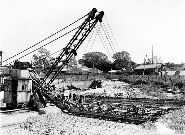
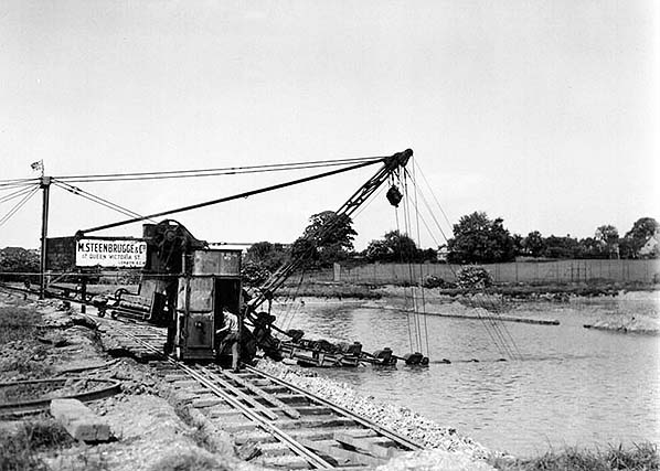
This view, taken at the same time as the previous view, shows the drag end of the same conveyor in the process of extracting gravel. In this instance the camera is facing due north. The machine, as can be seen, runs on a length of railway track and the whole set-up would be moved from time to time as circumstances required. The track gauge is not known but appears to have been in the region of 5ft 6in - 6ft and the machine probably ran on double-flanged wheels. Other than the address, little is on record about M Steenbrugge & Co. The firm was known, perhaps obviously, for being involved with quarrying and in particular the limestone industry. Whether Steenbrugge was working at Dunton Green in 1937 or the plant seen above was simply on hire from them is not known. The address, 17 Queen Victoria Street, is better known for being offices of insurance and financial concerns. It is located close to the Bank of England and a modern building now occupies the site. The Steenbrugge name is better associated with Belgian beers but it is not known if there was any connection with the quarrying business of that name.

A later view, this time from May 1947 and looking south-east. The drag scraper is removing what is known as 'overburden'; the word means unwanted material that overlies the substance being quarried. The work seen ongoing was a preliminary measure prior to excavating underwater gravel. This machine also bears the Steenbrugge name, just visible on the far left, but it is not known if this is the same machine as seen in the 1937 views. Certainly this type of machine could perform both the operations seen ongoing in these views.
As mentioned earlier, the narrow gauge internal railways around Dunton Green are something of a mystery. Referring to the first May 1937 image above, the skip wagons seen were of a standard type found in countless industrial locations. The skips were mounted on pivots, one each end of the frame, and were emptied by releasing a locking lever which allowed the skip to tip. They could be quite dangerous and incidents of the entire wagon overturning when being emptied were by no means unknown. These wagons remain common today; most are now at industrial museums but some can still be found derelict and decaying at long-abandoned former industrial sites in remote areas. The mystery surrounding Dunton Green is how these wagons were moved. Single wagons, even when loaded, could be, and often were, moved by manpower. On level track – level by industrial standards - two fit men could push one skip wagon with ease. Two or more wagons however, especially when loaded, would prove a problem for manpower and the May 1937 views shows a train of five wagons, and the machine would have all five loaded extremely quickly. Five loaded wagons would be totally out of the question for manpower so that leaves rope haulage, horses or locomotives and there is no evidence of any of these. By 1937 small narrow gauge internal combustion locomotives were commonplace but the track upon which the train of skip wagons sits appears too feeble to support even these small locomotives. Thus, in the absence of confirmed information on the narrow gauge lines at Dunton Green, the question of motive power will remain a mystery.
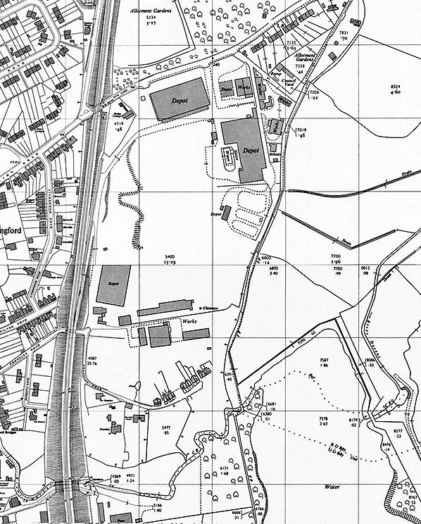
This 1963 map reveals some substantial changes in the brickworks area. Quarries have largely been infilled and many new buildings, marked simply as 'works' or 'depot' have appeared. Insofar as the northernmost part of the site is concerned, this would seem to be the beginnings of West Kent Cold Storage occupying the area. The clay pits had been exhausted in 1956 but the continued existence of a chimney in the southern part of the site might suggest that some related industry may have continued a while longer. Chimneys, of course, often remain standing long after they have become redundant. Wreford's Siding is in situ and would remain so officially for a further five years. More cottages have appeared on Pounsley Road while further north, adjacent to Rye Lane bridge, the former Railway Tavern is shown as 'Bridge Cottage'.
In 1956 clay reserves at Dunton Green were exhausted to the point where the operation was no longer viable. Chalk extraction continued until c1980 and this appears to have coincided with the expansion of the West Kent Cold Storage premises over the northern part of the brickworks site. The Tarmac Group gravel pits (now Chipstead Lake) also ceased operation at around the same time. Other gravel pits in the area remain in operation and are expected to do so until at least 2025. The last brickworks to cease operation in the immediate vicinity was the Greatness Works of Ibstock Brick, closing in 1991. The site was subsequently used for landfill by Messrs Cory. The recent history of the Dunton Green Brick, Tile & Pottery Works site as of 2016 is given in the caption accompanying the Railway Tavern image on the Dunton Green station page. Reminders of Dunton Green's brick industry are the Brickmaker's Arms, Chipstead, and Dunton Green Primary School and St John's church, Dunton Green, which were constructed with local bricks. St John's church is no longer consecrated and as of 2016 is in commercial use. Located on London Road, its full title is/was St John the Divine and the building was declared redundant as a church in 1987.
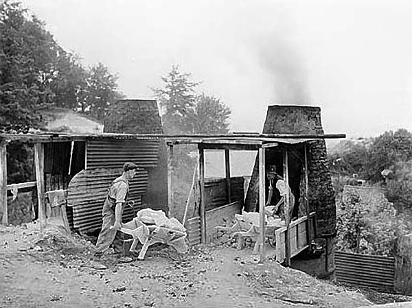
One, if not two, of the Dunton Green lime kilns in action in 1938. The wheelbarrows contain chalk for loading into the kiln, above the fire. The end product would eventually be retrieved from the bottom of the kiln via the channel on the right. It is not known if these are two of the kilns seen in the June 1931 image which appeared to be out of use, or at least out of use at the time that photograph was taken.
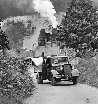 A lorry climbs the slope out of Dunton Green's lime works in 1938. One of the kilns can be seen creating smoke signals in the background. The precise colour of the smoke in this black-and-white view is difficult to determine but would appear to be white; if so the kiln is either burning wood or the kiln has recently been loaded with chalk and moisture is evaporating. The lorry's load is unclear from this angle but was probably the end product of the kilns. The lorry is a Bedford W series, either a WL or WT. Its registration number is JD 7103. The JD prefix was first issued in December 1929, the year prior to the founding of Bedford Vehicles, and the fairly high number, 7103, suggests the lorry was new late 1933 to early 1934. Bedford ultimately became part of General Motors and the Bedford brand name outlived the Luton-based company by five years, finally disappearing in 1991. The lorry seen above has signwriting but it is indiscernable and the only part that can be made out is ‘Brick Co.’
Location map drawn by Alan Young
SOURCES:


 Home Page