
SALTERFORTH BOTTOMS CORDITE STORE[Source: Alan Young]
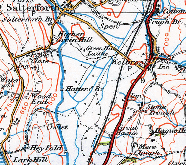
During the First World War the Ministry of Munitions opened a cordite store and dump at Salterforth Bottoms immediately south-west of Barnoldswick Junction and extending across what is now the B6383 road between Kelbrook and Barnoldswick (built in 1929) as far as Acornlea Hall near Foulridge. Cordite is an explosive; it was manufactured during World War 1 at various locations, including Gretna (where there was an extensive, purpose-built railway system including stations for workers on the site) but it is understood that no manufacturing was ever carried out at Salterforth. The site was selected because of its accessibility by rail and the absence of settlement on this almost flat valley floor (avoided because of its susceptibility to flooding); it also adjoined the Leeds & Liverpool Canal at the rear of Bashfield Farm where the boxes of cordite could be delivered or dispatched by barge. A number of storage huts were constructed on short concrete pillars at various locations within the site, around which was a perimeter fence.
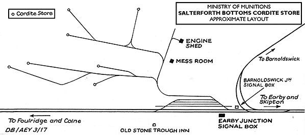
The facility at Salterforth Bottoms was open in 1916 as indicated by alterations to the Midland Railway Distance Diagrams which adds ‘Earby Ammunition Works Sidings’ 13 chains (286yd) from Barnoldswick Junction; the four sidings were constructed on the up side of the Skipton-Colne line. A new signal box called Earby Junction was built to serve the sidings. Within the munitions site a network of narrow gauge railways served the cordite stores which were spaced at safe intervals within the site; one of the branch termini was over 1¼ miles from the four ‘Earby Ammunition Works’ sidings. An engine shed was provided within the munitions site. The exact layout of the railway within Salterforth Bottoms is not known, but the accompanying map is a re-drawn sketch by Donald Binns in his book Skipton-Colne Extension (2008) and from which some of the material in this article is derived. The Ministry of Munitions railway system is shown on the accompanying OS One-inch Popular Edition map (Sheet 25: Ribblesdale). The publication date is 1924, but the revision is dated 1920, with a road revision date and minor corrections of 1933 and issue code of 1934.
Cordite can become unstable, therefore at the end of the war the supplies were destroyed by igniting them in fields by the store. The Salterforth Bottoms facility closed in 1923, but it is not known exactly when the railways within the site were removed. The revision information for the accompanying Ordnance Survey map implies that they were in situ in 1933, but because the site was crossed by the new Kelbrook to Barnoldswick road (B6383) in late 1929 the tracks must surely have been recovered by then. Binns notes that the sidings which served the Cordite site were in situ as late as 1927. The pillars that supported the storage huts survived into the 1950s. Some of the huts were bought and moved to various locations in the district.
A local historian writes that the proximity of this military installation gave Foulridge Methodist Chapel the distinction of being one of few buildings insured against zeppelin raids. Earby and District Local History Society’s website (see below) includes some images related to the Salterforth Bottoms cordite store. SOURCES
 Home Page Home Page
|
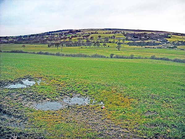 Looking south-westwards from the B6383 Kelbrook to Barnoldswick road in February 2017. From 1916 until the 1920s a network of sidings in the valley bottom served a Ministry of Munitions Cordite (explosive) store. The rails are thought to have been lifted by 1929 and the last remains of the storage huts disappeared in the 1950s.