Station Name: HELLESDON
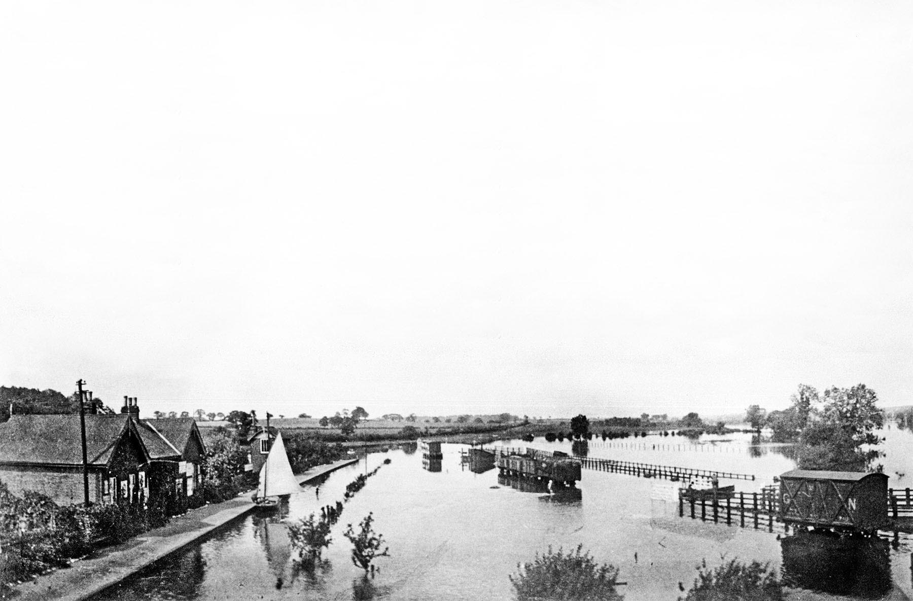 Hellesdon station was built on the floodplain of the River Wensum and nearby is the latter's confluence with the Yare. This view shows the result of the floods of August 1912. The Wensum is at the extreme righ, facing towards Drayton and taken from the now long since demolished bridge number 250 carrying Hellesdon Road over the line. A short distance behind the camera and still there today stands one of the famous A-frame bridges taking the line over the river. The approach to the station was via a short lane leading down from the west side of bridge 250, while the goods yard was accessed from the east side of the bridge and via the fenced ramp seen on the right behind the GNR van. At the bottom of the ramp, where the rowing boat can be seen, the road into the goods yard negotiated a dog-leg and continued between the two parallel lines of fencing to the goods dock and cattle pens. Cattle would be driven, ie walked, to or from the station and this is the reason for the provision of the fencing. The goods dock, ironically better seen in photographs taken after the line closed, appears to be hidden from view by the wagons. The axles and a large part of the wheels of the wagons remain visible so it can be estimated that the flood water in the goods yard was about twelve inches deep measured from ground, not rail, level. The running line was at a slightly lower level relative to the goods yard and about twelve inches of platform face remains above the water line. This would give a depth of water of about two feet above rail level; adequate for the sailing yacht at the platform. The yacht, which is not a Wherry, is of a type designed for shallow waters and can still be seen in Norfolk today. There appears to be somebody unloading items from the yacht, perhaps provisions for the station. Partly hidden by the yacht's sail is Hellesdon signal box, displaying its typical, but not universal, M&GN gables. By this date Hellesdon box had been abolished and replaced by a ground frame located adjacent to the goods yard points, some distance beyond the end of the platform. The box remained in use as a porters' room. Subsequent to the withdrawal of passenger services, the Drayton - Norwich City section effectively became a long siding. Opposite the platform and close to the yacht an object is visible protruding from the water. This is the 50¾ milepost. Measured from South Lynn, British Railways Working Timetables from 1953 give the mileage as 50 miles 73 chains. Hellesdon's milepost was replaced in 1923 by a concrete example, presumably manufactured at Melton Constable. This milepost survived demolition of the line in 1973 and lay, uprooted, in the undergrowth for many years. Rediscovered, it then spent time in a private garden and at the time of writing is back where it belongs at the small restored section of Hellesdon's platform. Hellesdon station was built on the floodplain of the River Wensum and nearby is the latter's confluence with the Yare. This view shows the result of the floods of August 1912. The Wensum is at the extreme righ, facing towards Drayton and taken from the now long since demolished bridge number 250 carrying Hellesdon Road over the line. A short distance behind the camera and still there today stands one of the famous A-frame bridges taking the line over the river. The approach to the station was via a short lane leading down from the west side of bridge 250, while the goods yard was accessed from the east side of the bridge and via the fenced ramp seen on the right behind the GNR van. At the bottom of the ramp, where the rowing boat can be seen, the road into the goods yard negotiated a dog-leg and continued between the two parallel lines of fencing to the goods dock and cattle pens. Cattle would be driven, ie walked, to or from the station and this is the reason for the provision of the fencing. The goods dock, ironically better seen in photographs taken after the line closed, appears to be hidden from view by the wagons. The axles and a large part of the wheels of the wagons remain visible so it can be estimated that the flood water in the goods yard was about twelve inches deep measured from ground, not rail, level. The running line was at a slightly lower level relative to the goods yard and about twelve inches of platform face remains above the water line. This would give a depth of water of about two feet above rail level; adequate for the sailing yacht at the platform. The yacht, which is not a Wherry, is of a type designed for shallow waters and can still be seen in Norfolk today. There appears to be somebody unloading items from the yacht, perhaps provisions for the station. Partly hidden by the yacht's sail is Hellesdon signal box, displaying its typical, but not universal, M&GN gables. By this date Hellesdon box had been abolished and replaced by a ground frame located adjacent to the goods yard points, some distance beyond the end of the platform. The box remained in use as a porters' room. Subsequent to the withdrawal of passenger services, the Drayton - Norwich City section effectively became a long siding. Opposite the platform and close to the yacht an object is visible protruding from the water. This is the 50¾ milepost. Measured from South Lynn, British Railways Working Timetables from 1953 give the mileage as 50 miles 73 chains. Hellesdon's milepost was replaced in 1923 by a concrete example, presumably manufactured at Melton Constable. This milepost survived demolition of the line in 1973 and lay, uprooted, in the undergrowth for many years. Rediscovered, it then spent time in a private garden and at the time of writing is back where it belongs at the small restored section of Hellesdon's platform.
Photo
from Jim Lake collection
| Last
updated: |
© 1998-2013 Disused Stations
| |

 Home Page