Kirkby is located seven miles north-west of Liverpool and until the Second World War it was a predominantly rural area. On 20 November 1848 the Lancashire & Yorkshire Railway (LYR) opened a railway between Bury and Liverpool which passed through Kirkby where a station was provided. The line went on to become a key part of the LYR network linking Liverpool to Manchester, the east Lancashire industrial towns and to Yorkshire. It became part of the London Midland & Scottish Railway (LMS) on 1 January 1923.
Even before Britain entered the Second World War on 3 September 1939 plans had been drawn up for a munitions factory to be sited on agricultural land to the east of Kirkby. Key factors in the choice of the location were its rural location and its proximity both to the railway and to an area with a large population from which workers could be recruited.
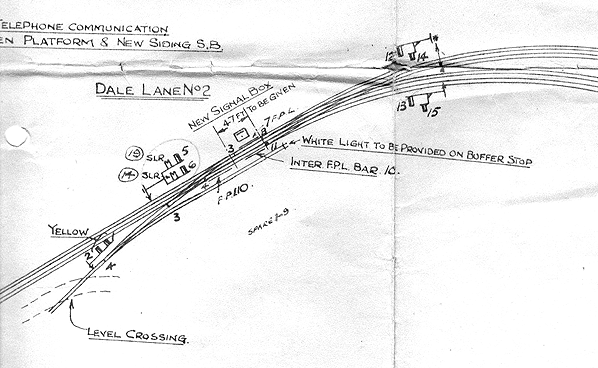
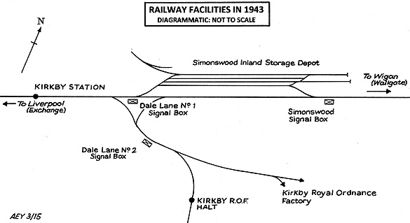
In 1940 a new triangle, leading off the main Liverpool Exchange to Manchester Victoria line, was opened at Dale Lane to serve the new Kirkby Royal Ordnance Factory, and a new passenger station for the factory workers was provided on the branch. All signalling was contracted out to the Railway Signal Company, Fazakerley. Dale Lane No.1 signal box opened on 8 May 1940 to control the junctions at the east and west ends of the triangle. The box was built to the LMS Air Raid Precaution (ARP) design , initially with a 30-lever, LMS REC pattern lever frame, manufactured by the Railway Signal Co, Fazakerley.
Dale Lane No.2 signal box opened about the same time to control the south junction of the triangle and the connections to the munitions sidings. It, too, was built to the LMS ARP design, but with a 15-lever, LMSR REC pattern lever frame, manufactured by the Railway Signal Co, Fazakerley. Kirkby Factory ground frame was an open, 5-lever, LNWR Sketch 446 pattern lever frame.
Signalling on the triangle was by Absolute Block, but between Kirkby Factory ground frame and Dale Lane No.2 signal box, only stroke bell signalling, without block instruments, was used.
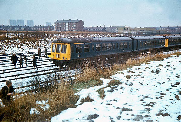
On 9 December 1940, a new passenger station opened adjacent to the munitions factory. This was exclusively for the factory workers and was controlled from a 5-lever ground frame at the east end of the station.
In connection with the munitions factory, a new down siding was installed at Rainford Colliery signal box; it led to a goods station at Dairy Farm Road. Loaded munitions trains were worked from the Kirkby Royal Ordnance Factory via the east curve of the triangle to the Rainford goods station, and the explosives were unloaded and taken by tractor and trailer across Dairy Farm Road to the nearby storage buildings. Here, explosives could safely be stored, remote from areas of population and away from likely enemy bombing targets in Liverpool.
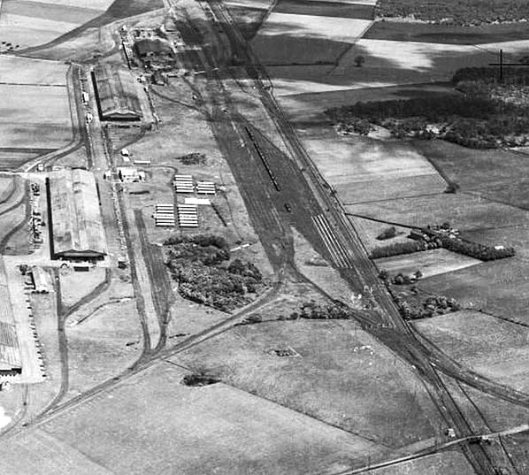
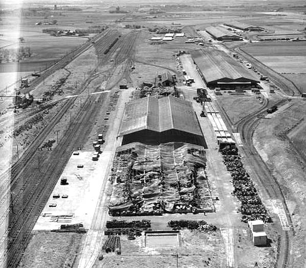
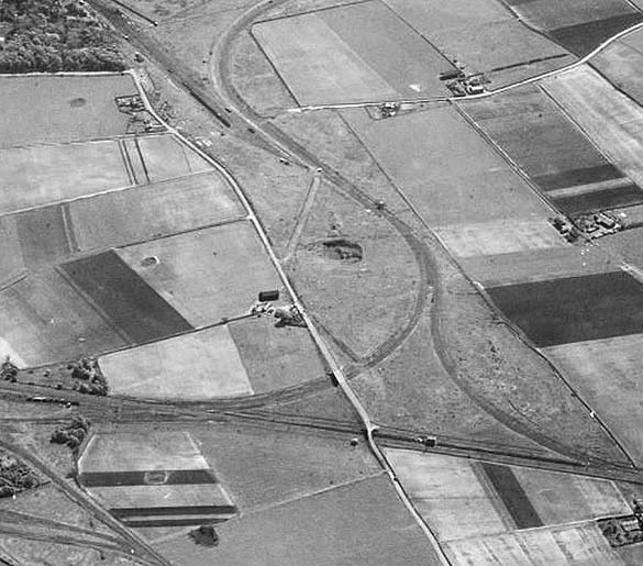
The Dale Lane triangle seen in 1947. The main line is seen running left to right Wigan being to the left and Liverpool to the right. Running from the top to bottom is Dale lane. to the left of Dale Lane on the main line in the centre of the triangle is Dale Lane Number 1 signal box.
Reproduced with the kind permission of Simmons Aerofilms Ltd
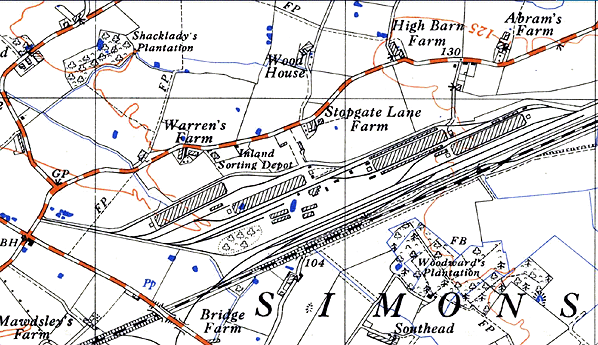
In 1942, Simonswood Inland Sorting Depot was opened to store imported goods away from the Liverpool ‘blitz’. The depot was rail-served, with four large storage sheds and a network of railway sidings; it was also served by road. Located on the north side of the main line the depot was connected to it at both its east and west ends. At the west end of the depot, Dale Lane No.1 controlled the connections and, to facilitate this, its frame was extended to 35 levers. The east end connections were controlled by a new Simonswood signal box. This opened in 1942 and was a LMSR ARP design signal box, replacing the old, 1884 built, Railway Signal Co box. The new box had a 40-lever ,LMS REC pattern lever frame, manufactured by the Railway Signal Co, Fazakerley. It also controlled two additional up and down goods lines to Rainford Colliery signal box.
The opening of the Simonswood Inland Sorting Depot completed the significant railway facilities at Kirkby. The area became very busy with the Royal Ordnance factory alone employing 23,000 workers at its peak of production. The Kirkby Royal Ordnance Factory produced 10% of all of the ammunition used by the British in the Second World War.
On 19 April 1945 there was an accident at the west fork junction at Dale Lane. A locomotive and brake van came off the west curve of the triangle and went onto the main line without authority to do so from the Dale Lane No. 1 signalman. It was run into by a Bradford to Liverpool Exchange express with the loss of six lives. As a result of the accident a further lever was installed in Dale Lane No.1 box to control a shunt-ahead signal underneath the down branch starting signal, which was situated at the west end of the triangle.
Kirkby Royal Ordnance Factory was intended to be a wartime-only facility and it closed after March 1946. The cessation date of railway operations is not recorded. Dale Lane No.2 signal box and the east fork line closed on 9 September 1951, after a period of disuse. The line to Kirkby Royal Ordnance Factory station would have closed at the same time, but appears to have been out of use for some time before this date.
The railway links to Simonswood Inland Sorting Depot were disconnected on 13 November 1960, but the exact date of cessation of rail traffic is not known. Simonswood goods lines were clipped out of use on 23 September 1963 and mothballed. They were permanently disconnected on 8 March 1964 and the signal box closed on 4th May 1965.
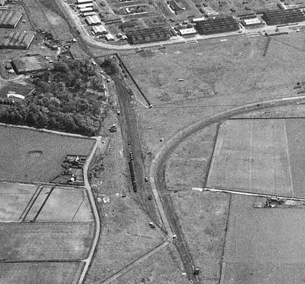
Kirkby Industrial Estate was built round the munitions factory area and rail traffic served the estate. Dale Lane No.1 signal box continued to control the west junction and west fork line, but only as sidings. The signal box was reduced to a ground frame on 8 May 1970 and closed on 2 September 1975. It was replaced with a 2-lever open ground frame which closed on 18 January 1976 after rail traffic had ceased.
On 8 April 2001 a new switch-panel ground frame opened at Dale Lane for new rail traffic, although this is now disused again, rail traffic having ceased.
Click here to see Kirkby Royal Ordnance Factory station
|


 Home Page