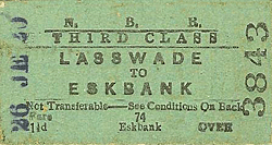
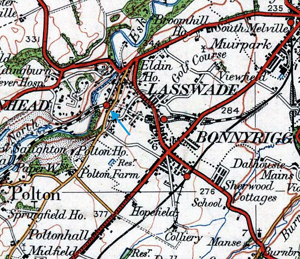
Notes: Lasswade was not one of the original stations on the line. It opened on 12 October 1868 after the North British Railway put pressure on the Esk Valley Railway to provide a station.
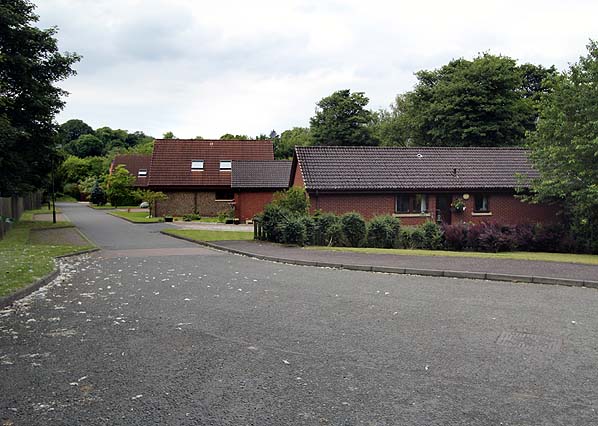
The curved platform was on the down side of the line between the west portal of Broomieknowe Tunnel (also sometimes known as Lasswade Tunnel), which it abutted, and the Lasswade Viaduct. Access to the station was from a steep track between Polton Road and Westmill Road. The main station building was rectangular in shape and of brick construction with a hipped slate roof. There was a glazed central section to the platform elevation in front of the waiting room. This building also housed the booking |
small.jpg) |
office. A smaller brick building, the gents’ toilet, stood to the east. The station’s name was laid out in stones on the side of the cutting opposite the east end of the platform.
There was a moderate-sized goods yard to the rear of the platform, accessed from the west. The yard comprised four short sidings; one running behind the platform went into a stone-built goods shed with a hipped slate roof. The yard, which did not handle livestock, included a 1 ton 10cwt crane. Lasswade gas works was immediately north of the goods yard, with St Leonards Paper Mill (closed 1965) a short distance to the north along Westmill Road; both would have used the railway. Access to the goods yard was controlled by a signal box behind the platform near its west end. The box had gone by the 1930s.
After closure to passengers in 1951 the station remained open for goods traffic. Edge stones were removed from the west end of the platform, which was partly demolished to ease the passage of passing trains on the sharp curve. The yard closed with the line on 18 May 1964 although by this time there was very little traffic.
BRIEF HISORY OF THE ESK VALLEY RAILWAY (More detailed history being prepared)
Lying on the banks of the North Esk River in Midlothian, the small village of Polton is situated in a deep gorge a mile south-east of Loanhead and a mile south-west of Bonnyrigg. During the 19th and 20th centuries Polton was associated with two large paper mills (Springfield Mill opened in 1742 and Polton Mill in 1850) and Mavisbank House lies nearby; it was once one of Scotland's finest buildings. It was designed by William Adam for Sir John Clerk as a summer residence and at a convenient travelling distance from Edinburgh while he was working there. From the late 19th century until 1951 it was used as a hospital for the mentally ill, but later, back in private ownership, it was gutted by fire in 1973 and is now a ruin. Author and poet Thomas De Quincey died at a cottage in the village in 1859.
The Peebles Railway opened on 1 February 1864, and it quickly became profitable, prompting a number of local schemes in and around the North Esk valley over the next two decades.
One of first was the Esk Valley Railway whose promoters wanted to build a short branch from the Peebles Railway to serve the paper mills along the North Esk Valley
 |
Discussions with the NBR started in January 1863. The EVR’s proposed route involved using Peebles Railway land and building a separate track parallel with the Peebles Railway for just over half a mile from the junction with the Edinburgh & Hawick line at Hardengreen. After diverging from the PR the line would continue eastwards through the northern part of |
Bonnyrigg to a terminus at Polton: a total length of just over two miles.
The EVR was strongly supported by the NBR who planned to lease and operate the line once it opened. There was, however, opposition to the scheme from the Caledonian Railway who had their own plans for new lines to the south of Edinburgh
The local company won through, obtaining its Act on 21 July 1863. Construction started on 5 September 1864, and arrangements for working the line were agreed with the NBR on 28 September. Initial progress was slow due to engineering difficulties and further ongoing opposition from the Caledonian Railway.
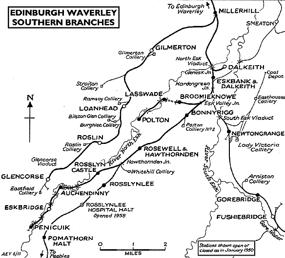 |
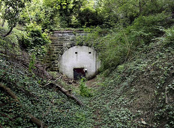
Although the single-track branch was only just over two miles in length it was heavily engineered for much of its route through the narrow North Esk valley. Major structures included the 430 yd Broomieknowe tunnel just east of Lasswade station and, beyond the station, a high six-arch stone curved viaduct taking the line obliquely across the North Esk valley. After this the line dropped sharply down the hillside before crossing back over the river by a much lower two-span girder bridge to reach the cramped terminus at Polton after a further half mile. Although only a mile from the town of Loanhead, Polton was hidden deep in the valley and could be reached only by steep and narrow minor roads.
The North British Railway (Lasswade and Branches) Act 1865 gave the NBR powers to construct a line from the unfinished EVR at Lasswade swinging north and west of Loanhead to Penicuik. This line was also planned to join the Edinburgh & Glasgow Railway to give access to the west. The powers were never taken up, although a branch to Penicuik from the Peebles |
 |
Railway did eventually open in 1872.
The Esk Valley Railway finally opened on 16 April 1867 with one intermediate station at Bonnyrigg. As both the EVR and the PR had their own tracks between the north-facing Esk Valley Junction and Harden Green Junction the two companies came to an agreement to share the two lines operating both as a section of double-track line.
.gif) |
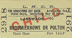
There were issues over station names. Before the branch opened, the NBR wanted to call the first station Bonnyrigg as it was closer to the town centre than Bonnyrigg station on the Peebles Railway. The PR were reluctant to change the name of their station despite protests from the NBR, claiming that a name change would confuse passengers. The PR were eventually persuaded to reconsider, and the PR station became Bonnyrigg Road in December 1866. As predicted by the PR passengers were confused, and the EVR station was renamed Broomieknowe on 1 August 1868. After pressure from the NBR a second intermediate station was opened at Lasswade just under half-a-mile west of Broomieknowe on 12 October 1868. After operating the line from the start the North British absorbed the Esk Valley Railway on 13 July 1871.
 |
In 1887 there were six daily trains in each direction between Edinburgh Waverley and Polton. There was, however, no early morning train: the first departure from Edinburgh was at 9.25am with a journey time between Eskbank and Polton of 12 minutes. There was no Sunday service. By 1922 there was one additional service leaving Edinburgh at 7.00am |
By 1950 there were still six trains in each direction, but by this time they carried very few passengers, and the line closed to passengers on 10 September 1951. It remained open for goods traffic until 18 May 1964 following the run down of the mills. Springfield Mill finally closed in the late 1960s.
The course of the Esk Valley Railway is traceable for much of its length although no part of it has been designated as a public footpath. The tunnel at Lasswade has been bricked up (with a locked door) at both ends although both portals are fairly easily accessible. Lasswade Viaduct is Grade B listed and is not accessible.
Ticket from Michael Stewart, route map drawn by Alan Young.
Sources:
To see other stations on the Esk Valley Railway click on the station name:
Broomieknowe & Polton |

viaduct_old5.jpg)
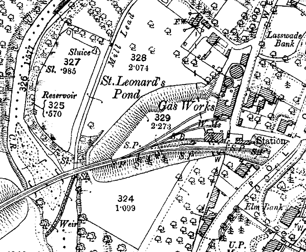
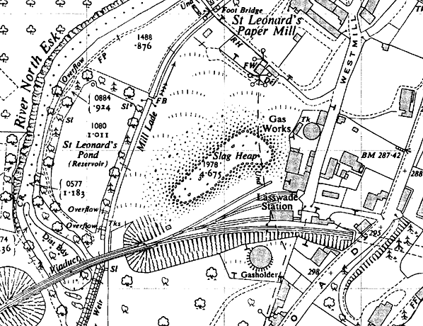 1950 1:2,500 OS map.
old4.jpg) Lasswade station c. 1930s.
Lasswade station c. 1930s.old3.jpg)
old7.jpg)
old1.jpg)
old8.jpg)
old_thumb2.jpg)
viaduct_old_thumb6.jpg)
 Home Page