Station Name: MIDDLETON-IN-TEESDALE
[Source:
Nick Catford]
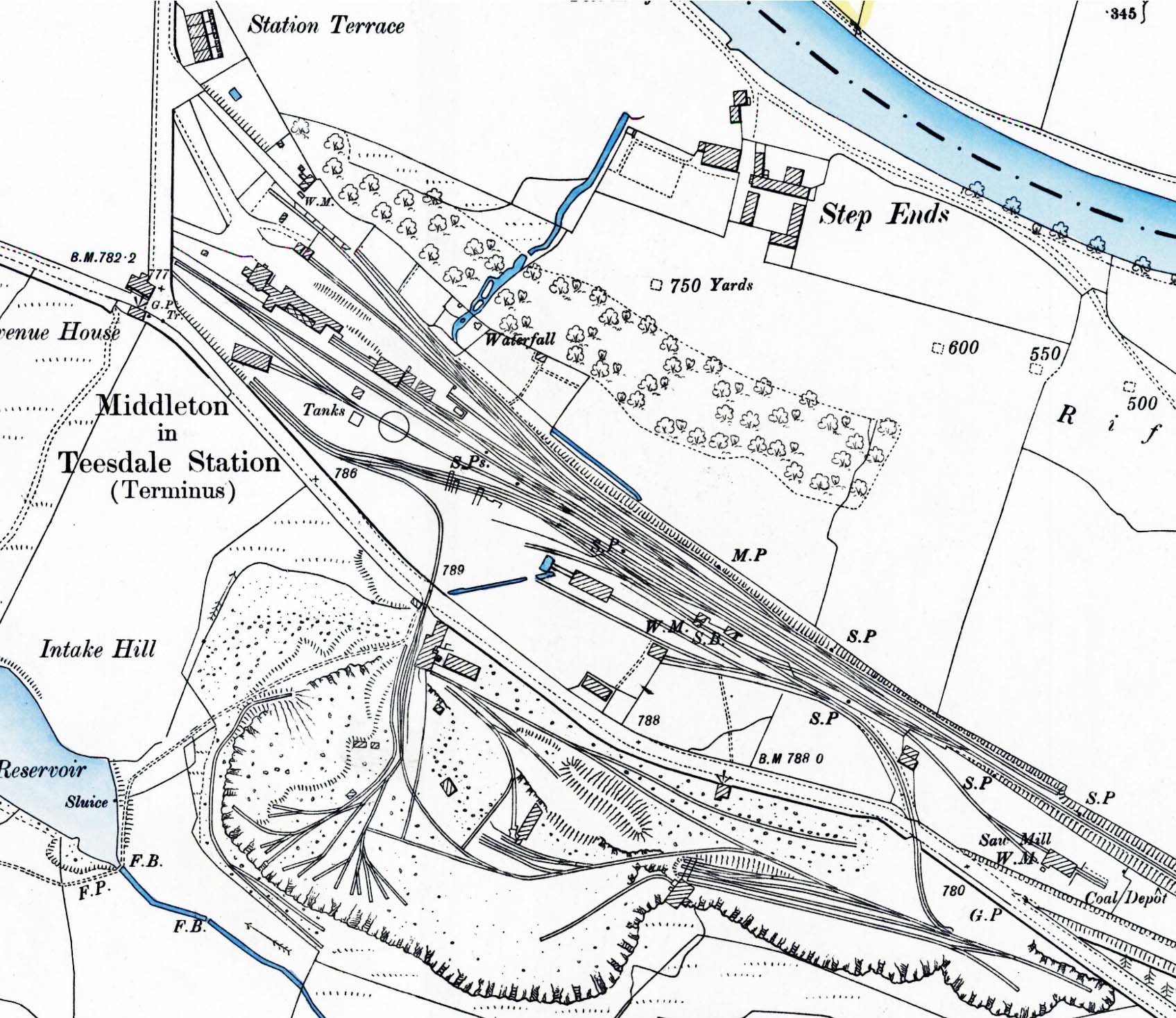 1897 1:2,500 OS map shows the layout of the station after the new buildings were added. The station building is seen on the left at the end of a small access drive. It comprises (left to right) the stationmaster's house, booking office (circa early 1890s) and waiting rooms and earlier booking office (1888/89); the hatched area is the verandah. Behind the platform the goods shed and supplementary goods shed are seen with livestock pens standing on the dock to the right of the shed. The siding running along the northern boundary of the yard was for coal. There is a separate access road for the goods yard with a weigh bridge and weigh office (WM = weighing machine) at the end of it. The run-round loop is seen opposite the station and running off it is the engine shed road with the dead-end single-road shed opposite the main station building. Two water tanks are sited either side of the shed road/loop as is the 45ft turntable. To the south-east of the station the signal box is seen on the down side; this controlled access to the goods yard and a number of private sidings. One private siding is seen bottom right; it is the London Lead Company's saw mill for the manufacture of pit props. The saw mill has its own weighbridge and coal depot. All of the other sidings to the south of the main line belong to Middleton Quarry. Two sidings run across the Mickleton Road into the quarry; one is just to the south-east of the signal box the other is north-west of the signal box. The rail-served building to the left of the signal box is probably an engine shed for the quarry locomotives. The River Tees is seen top right; this is the county boundary with the station being in Yorkshire whilst the town is in County Durham. 1897 1:2,500 OS map shows the layout of the station after the new buildings were added. The station building is seen on the left at the end of a small access drive. It comprises (left to right) the stationmaster's house, booking office (circa early 1890s) and waiting rooms and earlier booking office (1888/89); the hatched area is the verandah. Behind the platform the goods shed and supplementary goods shed are seen with livestock pens standing on the dock to the right of the shed. The siding running along the northern boundary of the yard was for coal. There is a separate access road for the goods yard with a weigh bridge and weigh office (WM = weighing machine) at the end of it. The run-round loop is seen opposite the station and running off it is the engine shed road with the dead-end single-road shed opposite the main station building. Two water tanks are sited either side of the shed road/loop as is the 45ft turntable. To the south-east of the station the signal box is seen on the down side; this controlled access to the goods yard and a number of private sidings. One private siding is seen bottom right; it is the London Lead Company's saw mill for the manufacture of pit props. The saw mill has its own weighbridge and coal depot. All of the other sidings to the south of the main line belong to Middleton Quarry. Two sidings run across the Mickleton Road into the quarry; one is just to the south-east of the signal box the other is north-west of the signal box. The rail-served building to the left of the signal box is probably an engine shed for the quarry locomotives. The River Tees is seen top right; this is the county boundary with the station being in Yorkshire whilst the town is in County Durham.
 Home Page Home Page
| Last
updated: Tuesday, 10-Apr-2018 00:22:10 CEST |
© 1998-2017 Disused Stations
| |
