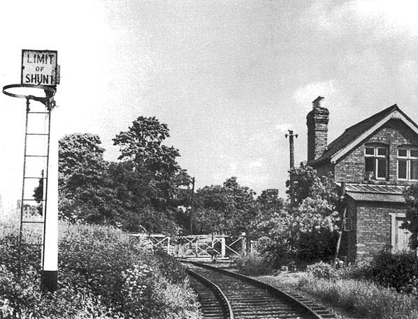
This is not the best of images in terms of the subject, but at the time of writing this is the only known photograph showing Todenham Road level crossing when the railway was still in existence. We are looking north with Moreton-in-Marsh station a short distance behind the camera. The crossing gates appear to be quite dilapidated which might suggest that the photograph was taken not long before the Shipston-on-Stour branch closed in 1960. The line south of this crossing was considered part of Moreton's goods sidings, as mentioned elsewhere, hence the presence of the Limit of Shunt warning. The short section south of the Limit of Shunt was therefore not governed by the 'one engine in steam' rule which applied to the rest of the branch. This would explain why and as also mentioned elsewhere these gates being reputedly unlocked, operated and locked by a member of station staff. There was a signal; believed Distant, a hundred or so yards behind the camera and another, presumably a Stop signal, north of the level crossing. This latter signal was located immediately north of the crossing and later, further north at Fosse Lodge. This would suggest interlocking between gates and the aforementioned signals which in turn would suggest the presence of a Ground Frame. However, while deductions based upon normal signalling practice, for the time, are all well and good the facts surrounding Todenham Road level crossing had proved elusive at the time of writing. Certainly there was very little that was 'normal' about the Shipston-on-Stour branch even in passenger days and it operated to the end, more akin to a largely un-signalled light railway.
Photo
received from Doug Parish


 Home Page