
Station Name: MURTON[Source: Darren Kitson]
Murton Station Gallery 3: c 1950s - March 2020
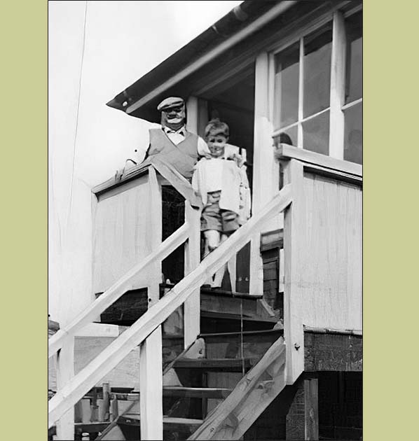
The steps of Murton Crossing signal box with the signalman and a young boy, perhaps a future railwayman, posing for the camera. Judging by the clothing, this view dates from sometime in the 1950s. The signalman has a badge on his cap but unfortunately the drawback of digitised photographs, it being the inability to zoom in without losing focus, prevents identification of the badge. The level crossing was out of view to the left.
Photo from Murton Railway Station History Group 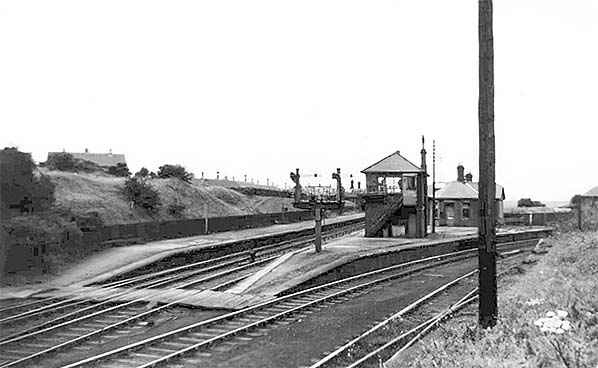
This south facing view is later than its general 'air' might suggest. To the right there is evidence of track lifting of the siding, right, which was intact in 1953 but has been lifted back to the points. Probably circa 1963. We see Murton's second signal box, dating from 1893 when it replaced the first which had stood in the space between this 'box and the station building. The second 'box was a North Eastern Railway Type N2 structure and fitted with a Stevens 53-lever frame. It was abolished in May 1964, after the Elvet branch had been disconnected at Murton in November 1963 having been used at this end, east of Hetton, for wagon storage (the branch also had a connection with the Leamside line).
Photo from Murton Railway Station History Group
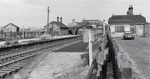 Very obviously taken some time after closure to passengers, this view faces north. The footbridge is by now in skeletal form, it having lost its ornate panels some years previously. The motor car, a Triumph TR3 which may have belonged to the photographer, is parked on the lane which led up from Murton Crossing and also gave access to the stationmaster's house, out of view. Point rodding is still in situ which means a pre 1964 date. At left can be seen Murton's small goods yard and shed along with the hand-operated crane, which latter was probably of 1½ ton capacity. The 1956 Handbook of Stations states by that year Murton was open to siding traffic only and with no mention of a crane, meaning the goods shed and crane were by that time out of use. Murton finally closed to goods and therefore all traffic in June 1960. Goods yard cranes had a habit of lingering, unless they were required for reuse elsewhere long after their services ceased to be required, so the presence of the crane in this view is of little use for dating purposes. Murton goods shed was quite diminutive and was served by a siding running along its east side, on the shed's right in this view. There would have been a platform inside the shed but whether there was an internal crane, which was the usual provision, is not known but the proximity of the yard crane to the shed suggests not. There was a doorway, visible here, giving access to the crane directly from the shed.
Photo from John Mann collection 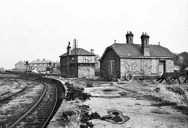
If the piles of permanent way and point rodding materials are anything to go by, this scene of desolation likely dates from early 1964, shortly before the remaining track of the former Durham Elvet branch, left, was lifted and the signal box closed. To the right can be seen the bufferstops of the goods yard sidings, closed in 1960, and the by now largely bricked-up former waiting room for the Durham line. Partly visible peeping out behind the left hand end of the building is the bay-windowed extension. The building's final use was probably as a store. The original signal box had stood dead ahead and roughly between the waiting room and this, the second signal box. One signal is 'off', indicating a northbound train is about to pass through. The white diamond on the signal indicates the presence of track circuiting on the track to which the signal applies. More properly it means 'Rule 55 does not apply' (information about Rule 55 is available online). Behind the signals can be seen what was latterly a platelayers hut although this is unlikely to have been its original purpose which may have been a lamp
room. The modern houses, left background, at least one of which has a television aerial, are part of Station Estate. This estate is dividedinto North, South and East sections. We are looking here at part of the North section. Construction began pre-war and was completed between 1950 and 1966. The estate has brought Murton much closer to the railway, or former railway as it now is, the centre of the pre-estate village being some distance, about one mile, to the east. The point is thus proven that new housing estates do not necessarily safeguard the future of rural railways as many people assume Photo from Murton Railway Station History Group 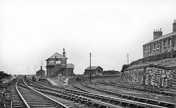 In this view the station has largely been demolished although the Elvet platform appears to be still intact. Recovery of signalling and apparently point rodding is underway. The rails of the Elvet branch are rusty and weeds are beginning to congregate. The Hetton - Murton section had been used for wagon storage between 1953 and 1958, Murton signal box did not close until May 1964 and therefore this view will date from around that time. This end of the Elvet branch was probably lifted as part of the same operation depicted here.
Photo from Murton Railway Station History Group 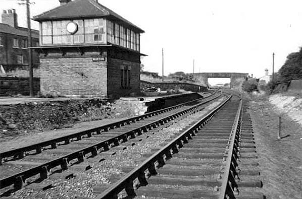 This north facing scene of desolation can be dated to 1964 and probably during the summer that year. The signal box still has its nameboard and clock but had closed in May. Signalling had been removed and the pointwork no doubt clamped. Not obvious unless this image is zoomed is that the track of the Elvet branch has been lifted to a point a few yards short of its junction with the Sunderland line; a document survives which mentions the Elvet branch had been removed from track mileage returns in 1964. In due course the signal box would be stripped of its fittings, including the clock, and points replaced with plain track with the line ultimately becoming single track.
Photo from Murton Railway Station History Group 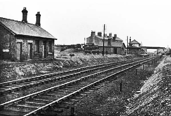
This is one of several views showing similar desolate scenes during the time after the platforms had been cut back to leave just an intact stub at the north end but not taken at the same time. On the left is the northbound (Down) platform building and beyond it the bufferstops of three of the four goods yard sidings. Murton closed to goods, therefore entirely, on 13 June 1960 and the signal box seen here closed in May 1964. Signal boxes between Ryhope and Heswall closed at widely varying times and by 1984 only Murton and Seaton Station (there had been another 'box at Seaton Bank Top) remained. Both closed in May 1984 by which time they had been converted to IFS (Individual Function Switch)
operation. In this post-May 1964 view the clock had been removed from the 'box and all signalling in the station area removed. The posts alongside the track to the right had carried signal wires. The building behind the bufferstops was the waiting room and presumably Gentlemen's toilet for the Durham Elvet platform. Built as a rectangular building, it later had a bay window added to its north side presumably to assist waiting passengers to see when their train was approaching. The railway cottages, centre background, comprised two terraces which were built at different times. These, the waiting room and the signal box were eventually demolished leaving the former Down platform building, left, and platelayers hut, right background, to survive a little longer. The platelayer's hut, although not strictly part of the station, was with the exception of the former stationmaster's house, the final building to survive. Photo from Durham University (Dr Gibby collection) 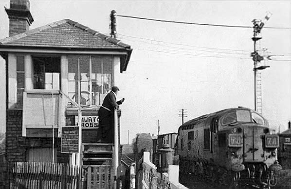 Another view of Murton Crossing signal box, this time with the gate wheel visible. The signal on the right at one time was mounted on a lattice post, later a rather lofty wooden post and by the time of this photograph a steel post. It has also gained a Distant arm which is here warning of the next signal being at Danger. Trundling through is an English Electric Type 3, later Class 37, with train 9J74. One source has dated this photograph to 1970 but without refining further. The locomotive, probably one of Thornaby shed's allocation, is wearing its original green livery and while there was nothing unusual about that in 1970 it is not yet carrying any form of yellow warning panel, suggesting earlier than 1970. Train 9J74 was one of what railway staff referred to as "J Turns". Their operation was quite complex, being Sunderland South Dock - Hawthorn Combined Mine (load train) - Tyne Dock Coal Terminal (unload train and run round) - Ryhope (run round) - Sunderland South Dock. Having passed southwards through Murton, trains reached South Hetton Junction where they turned east north-east onto part of what was referred to as the South Hetton Railway. This was a colliery railway which following Nationalisation of the coal industry became a National Coal Board line and therefore will not be found on the average rail atlas. This was the same line which the coal board used to access the fascinating complex of tracks at Seaham Harbour. The connection into what became Hawthorn Combined Mine was roughly midway between South Hetton Junction and Seaham. In later years British Railways/British Rail trains worked right into the Hawthorn complex and by the time this traffic ceased in 1991 coal trains were largely in the hands of Class 56 locomotives. The end of traffic in 1991 also meant the end of the railway through Murton. Another view of Murton Crossing signal box, this time with the gate wheel visible. The signal on the right at one time was mounted on a lattice post, later a rather lofty wooden post and by the time of this photograph a steel post. It has also gained a Distant arm which is here warning of the next signal being at Danger. Trundling through is an English Electric Type 3, later Class 37, with train 9J74. One source has dated this photograph to 1970 but without refining further. The locomotive, probably one of Thornaby shed's allocation, is wearing its original green livery and while there was nothing unusual about that in 1970 it is not yet carrying any form of yellow warning panel, suggesting earlier than 1970. Train 9J74 was one of what railway staff referred to as "J Turns". Their operation was quite complex, being Sunderland South Dock - Hawthorn Combined Mine (load train) - Tyne Dock Coal Terminal (unload train and run round) - Ryhope (run round) - Sunderland South Dock. Having passed southwards through Murton, trains reached South Hetton Junction where they turned east north-east onto part of what was referred to as the South Hetton Railway. This was a colliery railway which following Nationalisation of the coal industry became a National Coal Board line and therefore will not be found on the average rail atlas. This was the same line which the coal board used to access the fascinating complex of tracks at Seaham Harbour. The connection into what became Hawthorn Combined Mine was roughly midway between South Hetton Junction and Seaham. In later years British Railways/British Rail trains worked right into the Hawthorn complex and by the time this traffic ceased in 1991 coal trains were largely in the hands of Class 56 locomotives. The end of traffic in 1991 also meant the end of the railway through Murton.Photo from Murton Railway Station History Group 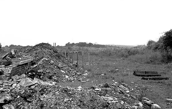 Looking south east along the branch platform in July 1978, Looking south east along the branch platform in July 1978,Photo
by Alan Lewis
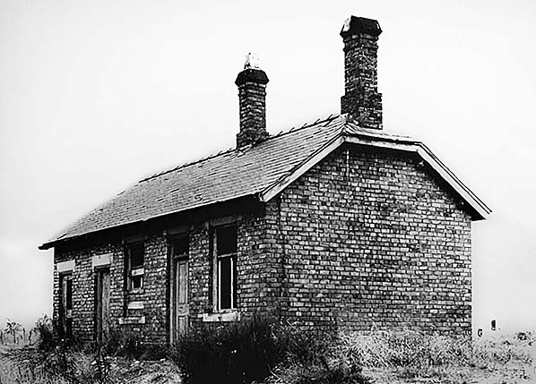
The former northbound platform building, its doors and windows by now looking very dilapidated yet the fabric of the building appears structurally sound c1960s/70s.
Photo from Murton Railway Station History Group 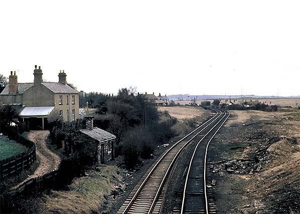
A south facing view taken from Murton Bridge and at Murton Crossing signal box in April 1979; signals protecting the level crossing can be seen in the distance. The southbound track has received some maintenance with a length of flat bottom rail on concrete sleepers being installed - this was the track which remained in use post 1984 when single line working was introduced. The northbound platform building which had survived closure of the station has by now been demolished. The other surviving building, seen here to the left, probably began life as a lamp room and perhaps also, given the two doorways, a coal store. No doubt it latterly served as a platelayers hut. In the left background stands the former stationmaster's house. As with the railway workers cottages, housing for stationmasters did not come free and a small rent was deducted from wages. Today the stationmaster's house is the only surviving former railway building in the immediate vicinity of Murton station. The cleared land of the right is the site of the junction with the line to Durham Elvet diverging to the right.
Photo by Alan Young 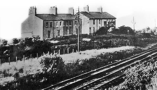
The point of this photograph was obviously the railway cottages but we can also see the overgrown mound which had been the northbound and Elvet branch platforms. It would seem the demolition of the station in the early 1960s involved, at the north end at least, merely cutting back the platform edge which was quite common practice. Railway cottages could be found at or very near to most stations. Occupied by railway workers who were deducted a small rent from their wages, these cottages were very necessary in an age when it was unrealistic for workers to have to travel any distance to reach their places of employment. Those who did have to travel did so on foot or bicycle at all hours and in all weathers. The railway cottages at Murton have long since been demolished and no trace of their existence remains, the site, in 2023, being open, grassed land.
Photo from Murton Railway Station History Group 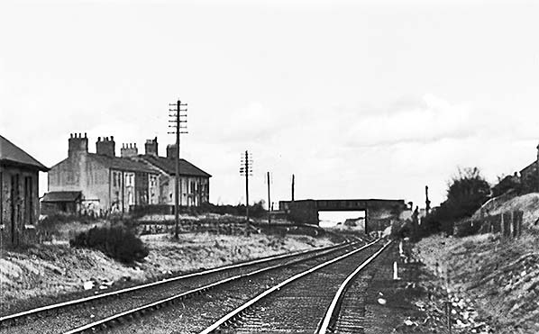
Another view showing the railway cottages but from a little further south. Telegraph poles are extant but it would appear the wires have been removed, perhaps to prevent theft of same. Murton Crossing signal box closed in 1984, following which the line was worked as single track and the northbound track here appears to be out of use although this could be a camera angle deception. At far left part of the station building can be seen. Quite why this and the small hut in the right background, marked by its chimney, were left standing is unclear but it may have been for use as permanent way stores. Both these buildings are shown in better detail in other photographs. The curves in the track have been somewhat exaggerated by the camera but nevertheless curves they were. The curves were probably the result of the need to make room for the inverted 'V' shaped platform when the line south from Murton, known at the time as the Haswell Branch, was built.
Photo from Murton Railway Station History Group 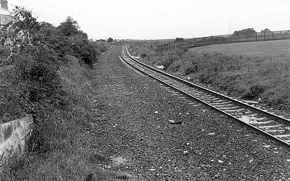
The site of Merton station looking south from Murton bridge in August 1985. The station master's house can just be made out on the left.
Photo by John Mann 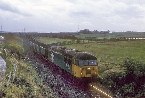
Just before dusk on 19 November 1992 a Class 56, which appears to be No. 56104, passes the site of Murton station on the by then single track line with a loaded coal train. Hawthorn Combined Mine, which incorporated Murton Colliery, had closed on 29 November 1991 but coal stockpiles still had to be removed and this train was on just such a duty. At this time the rapid loader at Hawthorn was still operational, but a number of mine buildings had been demolished. Sunderland South Dock crews were still working these trains as they had been doing for many years. The track curvature is a giveaway to the location as are the pylons in the background and the farm buildings at right centre background
Photo by Roger Geach reproduced from Geograph under creative commons licence 
This view dates from 19 March 2020 and is looking south from the site of Murton Bridge. There is no evidence, at least not from this vantage point, that Murton station, which was directly ahead of the camera, ever existed. The much altered former stationmaster's house stands on the left. Following dismantling of the line the deck, if not also the abutments, Murton Bridge was removed and the cutting infilled either side of the former bridge to provide access ramps to and from the trackbed. We are looking at the south side ramp in this view and therefore the trackbed at this point is now several feet below the surface. The trackbed emerges in the distance, between the trees.
Photo by Nigel Thompson reproduced from Geograph under creative commons licence
|

 Home Page