North Greenwich Photo Gallery 2: 1949 - March 2008
11.jpg) Aerial view of North Greenwich station in 1949. The raised trackbed for the station and adjacent engine shed is clearly seen. At this time the station site is being used by Wharfingers, who stored (sometimes dangerous) barrelled substances in the open air. The end of Saunders Ness Road is seen on the left. The footpath leading to the subway under the line is seen running west from the end of the road.
Aerial view of North Greenwich station in 1949. The raised trackbed for the station and adjacent engine shed is clearly seen. At this time the station site is being used by Wharfingers, who stored (sometimes dangerous) barrelled substances in the open air. The end of Saunders Ness Road is seen on the left. The footpath leading to the subway under the line is seen running west from the end of the road.
Photo
reproduced from Britain from Above with permission
12.jpg) North Greenwich station looking north in 1949. Wharf Road runs west opposite the station building. Wharf Road was cut into two parts when the Millwall Extension Railway was built. The site of the bridge over Manchester Road is seen top right. The buildings seen bottom left are part of the Midland Wharf paint which was built on the site of an earlier oil refinery and prior to that a horseshoe factory. The building on the corner of Wharf Road predates the railway.
North Greenwich station looking north in 1949. Wharf Road runs west opposite the station building. Wharf Road was cut into two parts when the Millwall Extension Railway was built. The site of the bridge over Manchester Road is seen top right. The buildings seen bottom left are part of the Midland Wharf paint which was built on the site of an earlier oil refinery and prior to that a horseshoe factory. The building on the corner of Wharf Road predates the railway.
Photo
reproduced from Britain from Above with permission
13.jpg) North Greenwich station looking south in 1949. The footpath running under the railway from the end of Saunders Ness Road is clearly seen middle left. Johnson's Draw Dock is seen top right. There is also a jetty here (just visible at the top of the picture) which was served by the Greenwich Ferry until 31 October 1902.
North Greenwich station looking south in 1949. The footpath running under the railway from the end of Saunders Ness Road is clearly seen middle left. Johnson's Draw Dock is seen top right. There is also a jetty here (just visible at the top of the picture) which was served by the Greenwich Ferry until 31 October 1902.
Photo
reproduced from Britain from Above with permission
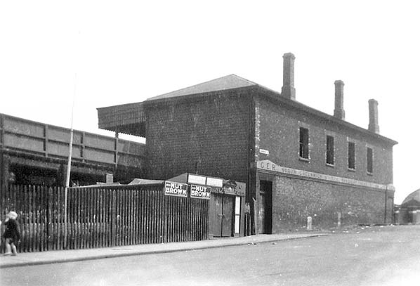 North Greenwich street-level entrance seen from Johnson Street c1950s. At this time the station building and canopy remains largely intact. The wording below the windows on the building states ‘GER North Greenwich & Cubitt Town Station’. Two advertisements for Nut Brown, a popular ale both then and now, are seen on the fence. A number of horseshoes above the adjacent door suggests this building might have been used by a farrier.
Photo from John Mann collection
9.jpg) After the line closure, the station was used by Wharfingers, who stored (sometimes dangerous) barrelled substances in the open air. In 1955 a serious fire broke out to the right of this photo, threatening houses which backed onto the yard. This view of barrels being stored in the yard is c1950. The station building still appears to be in good condition at this time.
After the line closure, the station was used by Wharfingers, who stored (sometimes dangerous) barrelled substances in the open air. In 1955 a serious fire broke out to the right of this photo, threatening houses which backed onto the yard. This view of barrels being stored in the yard is c1950. The station building still appears to be in good condition at this time.
Photo
from J. E. Connor collection
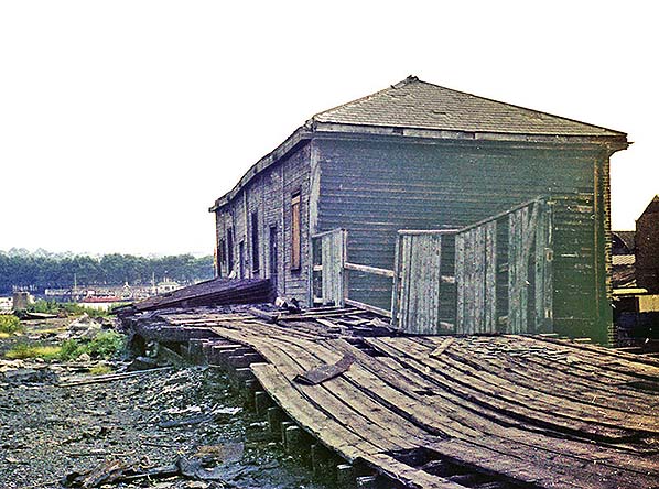 By June 1968 at platform level the station is now in very poor condition. The lower floor of the building is still being used by the Poplar, Blackwall & District Rowing Club at this time.
Photo
by Nick Catford
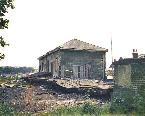
3.jpg) Another view of the dilapidated platform at North Greenwich station in June 1968. The Cutty Sark is seen moored at Greenwich on the south bank of the Thames.
Another view of the dilapidated platform at North Greenwich station in June 1968. The Cutty Sark is seen moored at Greenwich on the south bank of the Thames.
Photo
by Nick Catford
 North Greenwich station looking south towards Greenwich in June 1968.
Photo
by Nick Catford
8.jpg) North Greenwich station seen from Ferry Street (formerly Johnson Street) c1968. Alongside the station building a short footpath leads to the subway running under the line to Saunders Ness Road (formerly Wharf Road). The building to the left of the station appears to have found a new use as the Ideal Bar. Clearly no longer ideal as, within a year, the station and the Ideal Bar would be demolished.
North Greenwich station seen from Ferry Street (formerly Johnson Street) c1968. Alongside the station building a short footpath leads to the subway running under the line to Saunders Ness Road (formerly Wharf Road). The building to the left of the station appears to have found a new use as the Ideal Bar. Clearly no longer ideal as, within a year, the station and the Ideal Bar would be demolished.
Photo
by JE Connor
5.jpg) North Greenwich station seen from Saunders Ness Road (formerly Wharf Road) c1968. When the Millwall Extension Railway was built Wharf Road was cut off just before its junction with Ferry Street. A subway under the line was built to allow passengers from Wharf Road to reach the station. The east end of the subway is seen on the far right behind the fence.
North Greenwich station seen from Saunders Ness Road (formerly Wharf Road) c1968. When the Millwall Extension Railway was built Wharf Road was cut off just before its junction with Ferry Street. A subway under the line was built to allow passengers from Wharf Road to reach the station. The east end of the subway is seen on the far right behind the fence.
Photo
by JE Connor
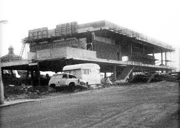 The North Greenwich station building was demolished in 1969 because it was in a dangerous condition. A new clubhouse for the Poplar, Blackwall & District Rowing Club is seen under construction on the station site c1970. In latter years the building had been used by the rowing club.
Photo
from Mick Lemmerman's Isle of Dogs - Past Life, Past Lives blog.
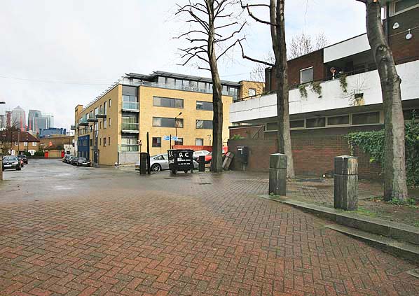 The site of North Greenwich station looking north in March 2008. The station was sited between the north end of the first building on the right (The Poplar Blackwall & District Rowing Club) and the south end of the second building. The later Island Gardens station was sited slightly to the north entirely on the site of the second building. The Millwall viaduct can be seen in the background.
Photo
by Nick Catford
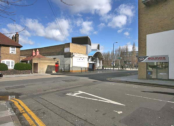 Looking north from the site of North Greenwich Station in March 2008 - the Millwall viaduct can be seen on the north side of Manchester Road.
Photo
by Nick Catford
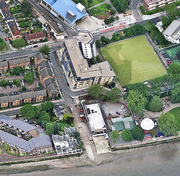 Recent aerial view showing the site of North Greenwich station. The station occupied the area covered by the north end of the building to the right of the slipway and the south end of the building to its north. The Millwall viaduct can be seen to the north of this building running across Millwall Park. The building to the right of the viaduct is the DLR's Island Gardens station
Click on thumbnail to enlarge

thumb15.jpg)
thumb4.jpg)
thumb10.jpg)

 Home Page