
Station Name: PADIHAM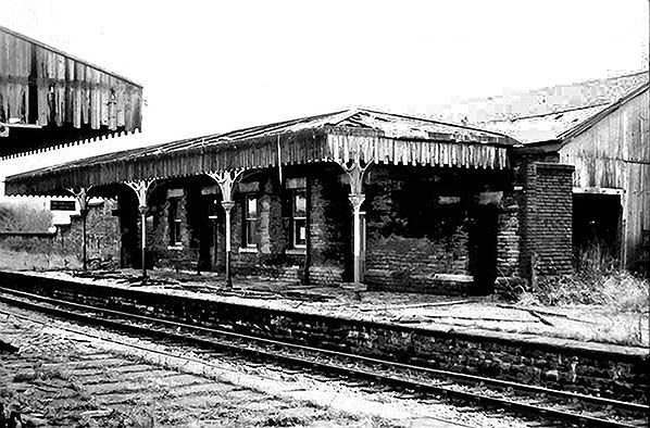
Taken during the demolition of Padiham station in 1967, this view is of the up platform and building. Planks from the wooden awning lie on the platform floor. Nature has certainly taken over here as can be seen by the weeds and grass. Behind the up building is the wooden goods shed which looks to be locked up. To the left you can just see the top of the glass covered ramp that led from the subway under the tracks up to the platform. This photo was taken from the down platform looking towards Rose Grove. The demolition of the station was the most problematic of the three as the line through it was still being used to serve the power station.
Photo from Jim Lake collection 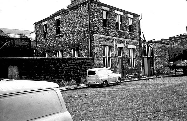 Taken in 1967, the demolition crew start on Padiham station. Here we can see the street level building and the public entrance to the right. The windows of the first floor station master's house are open, and the roof over the public entrance is being removed. To the left, part of the steps and walkway can be seen; these gave access to the station master's house. There is no exact date for the photo but the station's demolition was completed 19 August 1967. Taken in 1967, the demolition crew start on Padiham station. Here we can see the street level building and the public entrance to the right. The windows of the first floor station master's house are open, and the roof over the public entrance is being removed. To the left, part of the steps and walkway can be seen; these gave access to the station master's house. There is no exact date for the photo but the station's demolition was completed 19 August 1967.Photo from Jim Lake collection 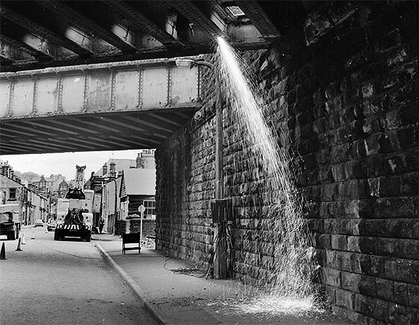
Stand back! Work begins on the removal of one of the railway bridges over Station Road, Padiham 5th June 1968. This bridge served the goods yard and up refuge siding. Sparks fly down to the street as one of the girders is being cut.
Copyright photo from the Burnley Civic Trust Heritage Image Collection
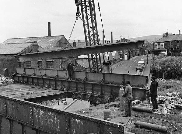
Another view of the bridge removal over Station Road, Padiham 5 June 1968, just prior to the goods yard closing. The removal is well under way as we see the side panels being taken away. Health and safety rules must have been very different in those days! Behind us was the second bridge over the road. This was spared as it carried the lines down to the power station. This view is from the Rose Grove (east) side.
Copyright photo from the Burnley Civic Trust Heritage Image Collection 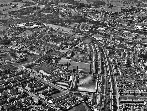
A lovely view taken from the air of the town of Padiham, 27 August 1982. The remains (now single line) of what was the North Lancashire Loop railway runs right through the middle of the town from Rose Grove in the east, around the left hand curve past the former station area and onwards to the power station which is just out of sight to the left in the west. Click here for a larger version.
Copyright photo from the Burnley Civic Trust Heritage Image Collection 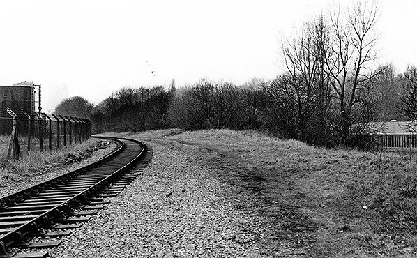 A view from more or less the western end of the former up line beyond the power station looking east towards Padiham in March 1987. The line from here to Rose Grove was singled in June 1969; the removed line was the former down line. A view from more or less the western end of the former up line beyond the power station looking east towards Padiham in March 1987. The line from here to Rose Grove was singled in June 1969; the removed line was the former down line.Photo by John Mann 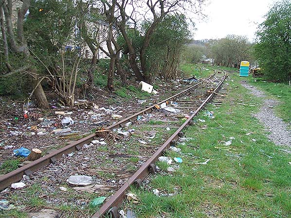 From April 2008, this photo shows the sorry state of the remaining up line that lead from the former power station, through the centre of Padiham leading up to Rose Grove junction with the East Lancs line. This remaining 1 mile and 76 chains was all that was left of the loop line. The last trains ran along here in July 1993. You can see that the track bed has become an unofficial dumping ground. The track bends to the left on the approach to the former station site, the bridge in the distance is Green Lane bridge that carried the running lines over the lane. In this view, we are looking west. The photo was taken from the Rose Grove side of Padiham. From April 2008, this photo shows the sorry state of the remaining up line that lead from the former power station, through the centre of Padiham leading up to Rose Grove junction with the East Lancs line. This remaining 1 mile and 76 chains was all that was left of the loop line. The last trains ran along here in July 1993. You can see that the track bed has become an unofficial dumping ground. The track bends to the left on the approach to the former station site, the bridge in the distance is Green Lane bridge that carried the running lines over the lane. In this view, we are looking west. The photo was taken from the Rose Grove side of Padiham.Photo by Roger Christian Rawlinson 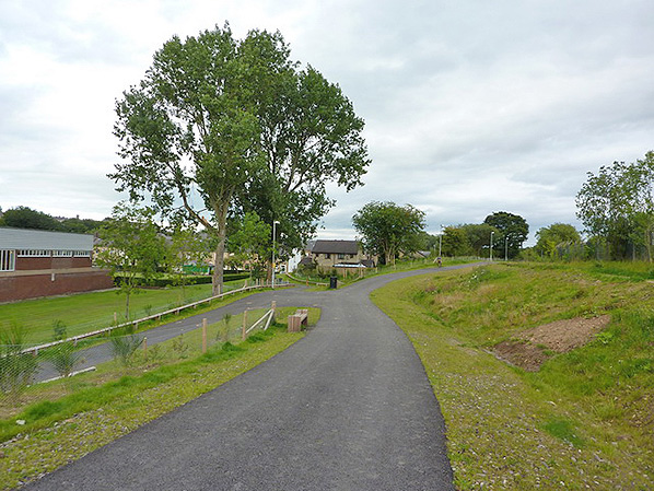
The location of Padiham station looking east towards the town and Rose Grove in August 2010. The area to the right was the up platform and building, behind that (continuing right out of sight) was the goods shed and yard. A housing estate has since been built over the goods yard area. On the left was the down platform and building.
Photo
by Alexander Kapp, reproduced from Geograph under creative commons licence
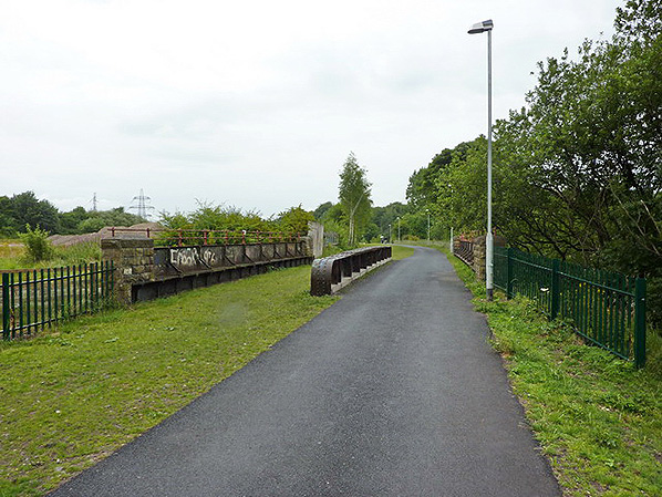
The bridge over Station Road, Padiham in August 2010. It was just before the station to the east. The tarmac path covers the former down line side. The station platforms started where the path curves to the left just beyond the bridge. The former trackbed here now forms part of the Padiham Greenway walking and cycling path.
Photo by Alexander Kapp, reproduced from Geograph under creative commons licence 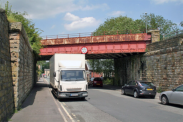 This surviving bridge over Station Road seen in June 2011 carried the main running lines into the station. The right hand side is the eastern (Rose Grove) end. In front of this bridge was a second almost parallel bridge serving the goods yard and up refuge siding; this bridge was removed in June 1968.
Photo by Dr. Neil Clifton, reproduced from Geograph under creative commons licence
|

 Home Page