
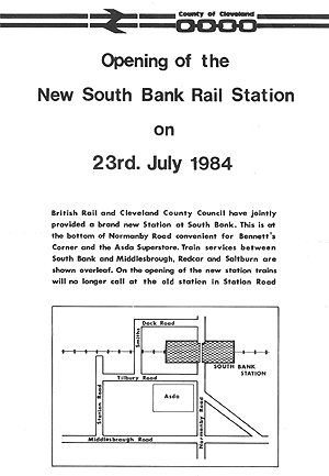
Station Name: SOUTH BANK (3rd site)
|
| Date opened: | 23.7.1984 |
| Location: | On the Middlesbrough – Saltburn railway line, 700yd east of South Bank (2nd) station; north end of Normanby Road. |
| Company on opening: | British Rail (Eastern Region) |
| Date closed to passengers: | Still open |
| Date closed completely: | Still open |
| Company on closing: | Still open |
| Present state: | Two platforms. Staggered layout with up platform west-south-west of the footbridge which gives access to the down platform, east-north-east of the bridge. |
| County: | Yorkshire (North Riding) |
| OS Grid Ref: | |
| Date of visit: | 20.7.1984 |
Notes: This station replaced South Bank (2nd) which closed on 23 July 1984. The second station stood in what had been a busy industrial area, and it was accessible from a residential area, but the industry had closed and passenger numbers had dwindled. The new station was close to an ASDA supermarket and within walking distance of housing.
The minimal service reflects continued change at South Bank. The supermarket has closed and there is little for the station to serve, with scattered industrial sites accompanied by extensive car and lorry parks, grassed sites awaiting new uses, and no adjacent housing.
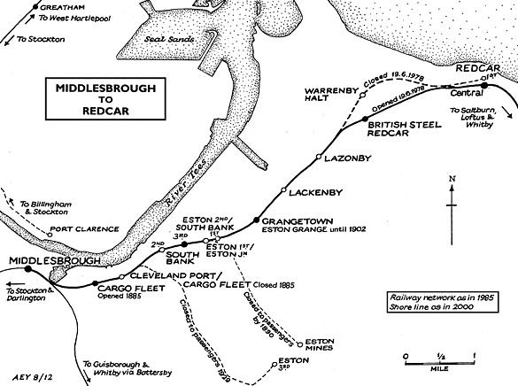
MIDDLESBROUGH AND THE SOUTHERN BANK OF THE RIVER TEES From the 1840s ironworks were established close to Middlesbrough, and the discovery of good quality ironstone in the Cleveland Hills near Eston several miles south-east of the town, prompted the rapid expansion of the industry along the southern bank of the Tees; a branch line from the Eston mines contributed traffic to the line through South Bank. In 1862 the Chancellor (later Prime Minister) Gladstone recognised Middlesbrough’s huge potential when he described the growing town as an ‘Infant Hercules’. By the 1880s there was an ironmasters’ district with a complex of furnaces, rolling mills, sheet mills, foundries, wire mills, coke ovens and concrete works served by an extensive and intricate network of railways. When steel supplemented iron production the local Cleveland ore was found unsuitable, so ore was imported from abroad, and this required additional docks and sidings. South Bank was in the midst of this industrial zone.
By the 1920s several miles of the southern shore of the Tees adjoining the Middlesbrough to Redcar line, on which South Bank station was situated, were lined with industry. Since WWI iron and steel had been joined by chemicals, originally at Billingham on the Durham (north) bank, but in the following decades oil refining and petrochemicals were added to the mix, and the Wilton plant, producing synthetic textiles, sprawled across an extensive site south of the railway several miles east of South Bank. This busy industrial region continued to grow in the 1960s as tidal mud banks of the Tees estuary were reclaimed for new factories and docks, and the author’s recollection of his first train journey between Middlesbrough and Redcar in 1963 was of a tormented landscape swathed in smoke and steam, a nauseous smell of sulphur, and huge expanses of sidings where steam locos were hauling and shunting rakes of wagons. Whilst de-industrialisation set in elsewhere by the 1970s, Teesside’s heavy industries battled on, and their thirst for water was a principal reason for damming the North Tyne, seventy miles away, to create Kielder Water reservoir (which inundated part of the former Border Counties Railway at Plashetts). In 1979 Britain’s last integrated steel mill - including Europe’s largest blast furnace - opened at the mouth of the Tees near Redcar. This necessitated the diversion of a stretch of the Middlesbrough – Redcar Railway and the construction of yet another complex of sidings. However, even as the new steel mill was under construction, Teesside was following the rest of the heavy industrial regions into rapid decline, and in the 1980s-90s many of the factories were abandoned. The scenes of dereliction along the railway route were as ugly as they were distressing. From the early 1990s, as work progressed to transform the Tees estuary from its grossly polluted state, reclamation was carried out of the derelict industrial land; a ‘flagship’ development on a brownfield site is the Riverside Stadium, home of Middlesbrough FC, which opened in 1995. However, much of the land adjoining the southern shore of the Tees remains bleak with industrial sites scattered around the open spaces which are still waiting to be used. The recent recession has hit Teesside badly, and the prospects for further developments to improve the economy and aesthetic appeal of the southern bank of the Tees in the near future look gloomy. BRIEF HISTORY OF THE MIDDLESBROUGH & REDCAR RAILWAY The Middlesbrough & Redcar Railway, authorised by an Act of 21 July 1845, opened to passengers on 5 June 1846, but from the outset the line was an important goods route. The first train was hauled by Locomotion No 1. The original Middlesbrough station was replaced with a new facility the following year, and the present station opened in December 1877. The line was leased to the SDR on 1 October 1847 and formally amalgamated with this company on 30 June 1862. In turn, the North Eastern Railway (NER) absorbed the SDR on 13 July 1863. At the eastern end, the original terminus at Redcar was replaced on 19 August 1861when the line was extended to Saltburn. In the late nineteenth century Redcar, Marske and Saltburn developed as holiday resorts, serving as playgrounds for the burgeoning population of Middlesbrough and its conurbation, but they also aspired to attract visitors from further afield. The route of the Middlesbrough & Redcar Railway was on the flat land south of the Tees, within a mile of the river bank, the steepest stretch of the line being a rise at 1in 242 on the approach to Redcar. Stations on this line present a challenge to railway historians, as some of their dates of opening are difficult to establish, some were probably or definitely re-sited, and names were changed and even exchanged between stations: South Bank was one such location. In 1861 a mineral line opened from Normanby Jetty on the Tees, a short distance north-west of South Bank to Normanby mines and beyond, with a link built from the Middlesbrough – Redcar line in 1865. On 1 January 1902 a passenger service was introduced on this line from Middlesbrough to a new terminus at Eston; this branch was remarkable in having no intermediate stations in the three miles between Cargo Fleet Junction and Eston. The passenger service to Eston lasted only until 11 March 1929, a casualty of motor bus competition. Tickets from Michael Stewart. Bradshaw from Nick Catford. Route map drawn by Alan Young. Sources:
See also: Cargo Fleet, South Bank (2nd site), Eston (1st site) & Eston (2nd site) |
bank3.jpg)
Photo by Alan Young
bank1.jpg)
setting of the station will be noted.
bank2.jpg)
Photo by John Mann
bank8.jpg)
Photo by Stephen Baker from his Flickr photostream
bank5.jpg)
Photo by Stephen Baker from his Flickr photostream
Photo by Stephen Baker from his Flickr photostream
bank7.jpg)
station in September 2008.
Photo by Stephen Baker from his Flickr photostream

 Home Page
| Last updated: Friday, 26-May-2017 10:59:36 CEST |
© 1998-2012 Disused Stations
|