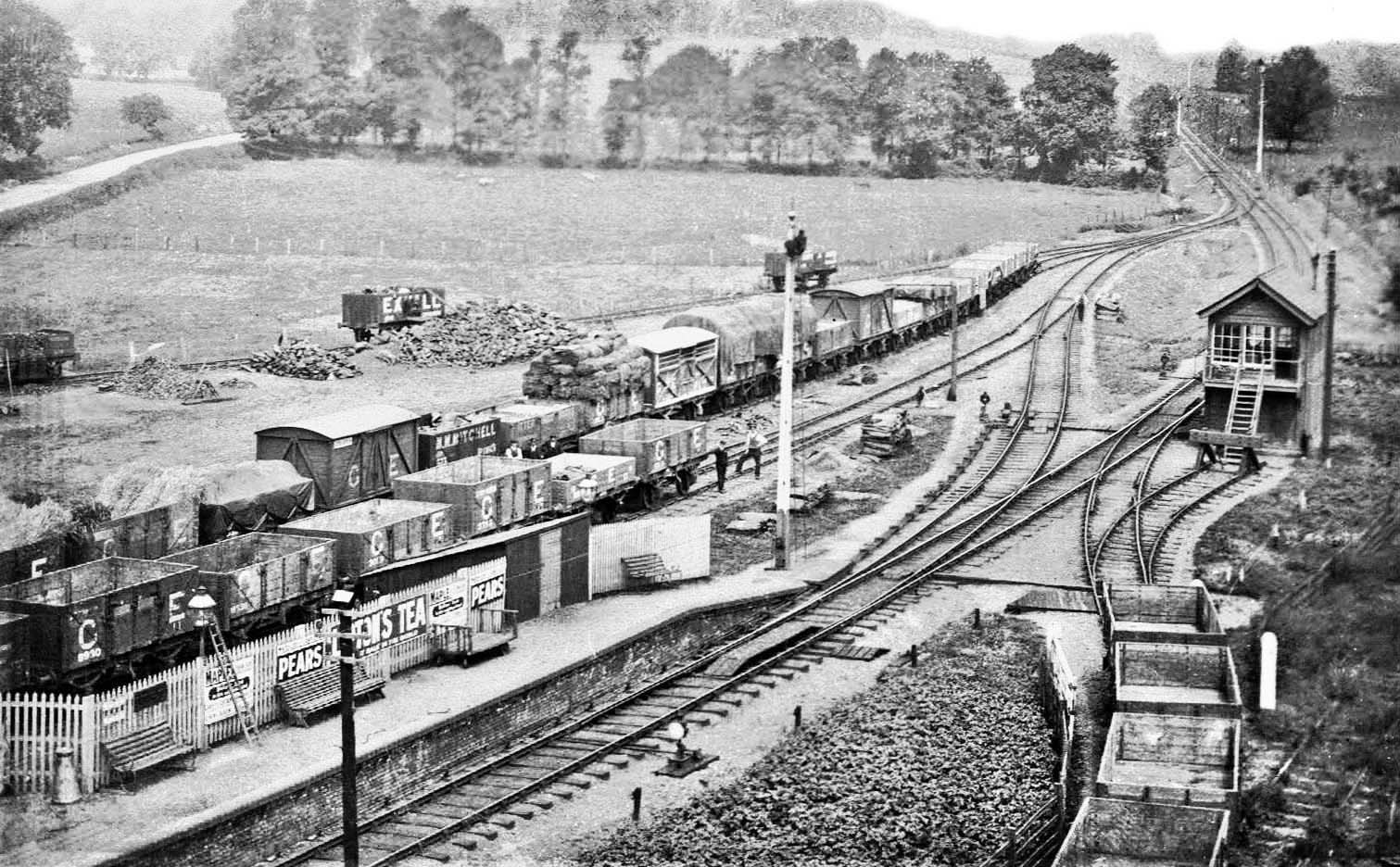
Station Name: STANDONA view looking north across Standon goods yard with part of the station platform visible at lower left. The date of this postcard photograph is unknown but there are clues. It is photographed from the adjacent flour mill which dated from 1901, therefore this is the earliest possible date. The mill, more correctly 'flour mills' as the 1901 mill was linked to the earlier corn mill on the opposite side of the River Rib which is out of view to the right, was served by the siding seen at bottom right. It was a private siding, hence the presence of the gate marking the boundary with railway land, and the running line was protected by the short trap siding ending at buffers beside the signal box which had a Saxby & Farmer 20-lever frame with duplex locking. Note the various shunt signals and points indicators located around the site. The tall signals were necessary due to the curvature of the line through and either side of Standon station. On the platform an array of typical period advertisements can be seen, along with a conical mike churn while a ladder is propped against an oil lamp. These lamps required a lot of attention; filling with paraffin; wicks trimmed; casement glass cleaned; lighting and extinguishing as necessary. This work was usually the job of a porter. The wooden hut just before the platform ramp is curious as it appears to be erected at ground level behind the platform and if so would have internal steps leading to the door onto the platform. The purpose of the hut is unknown, as is whether or not it also had access from ground level. Such huts on or adjacent to station platforms were usually lamp rooms, but in this instance the peculiar design means this use should be treated with caution. The goods yard was conveniently laid out with access from both Up and Down directions, but in practice the collecting and dropping-off of wagons would have been done when the goods train was operating in the Down direction, ie towards Buntingford. Two goods loading gauges are present, one to the left of the trap points, right of centre, with the other just visible in the distance just before the junction between sidings and running line. The existence of the loading gauge to the left of the trap points is rather strange as that further along near the junction would render it superfluous. The goods yard was not provided with a crane, thus limiting the categories of goods which the yard could handle; the yard did not handle livestock. The wagons present are mostly those of the Great Eastern Railway but there is at least one Southern Railway example and four private owner wagons. The name on the wagon on the coal siding and adjacent to the coal heap is obscured by appears to be 'Exhall' but this leaves us with a puzzle. If the name refers to Exhall Colliery, this was located near Bedworth, Coventry, but the location of the wagon's home base can be seen under magnification to be Darlington. Another wagon, this time nearer the camera, carries the name M.M.Mitchell and the home base of Ipswich. The firm had been Booth & Mitchell but the partnership was dissolved in 1907. M.M.Mitchell was, in full, the rather unusual name Margetts Mitchell Mitchell. Margetts died on 29 January 1928 and the record of her death states occupation as 'coal factor' so from this we know Margetts continued running the business subsequent to the dissolving of the partnership with Booth. Whilst we can establish the date of the photograph to be no earlier than 1901, the M.M.Mitchell wagon would therefore suggest no earlier than 1907. Another wagon of interest is that coupled to the cattle wagon. It is an open wagon loaded with what appears to be bales or sacks and, as it happens, illustrates well the purpose of goods loading gauges. Quite what commodity is loaded onto the wagon will never be known but it seems to be something which would not matter if it were exposed to wet weather, such as old rags used in the production of paper. Standon once had a paper mill, located south of the village on Paper Mill Lane and close to the spot where the railway crossed the River Rib on a skew bridge. However, as far as can be determined the paper mill ceased operations sometime in the latter half of the 19th century so, if correct, the wagon is unlikely to be loaded with rags unless destined for another paper mill elsewhere. Two further open wagons, extreme left, are loaded with what appears to be bundles of reeds, perhaps for thatching. Lightweight wagon loads such as this and the bales or sacks were most uneconomical for the railways and the items seen in this view, coal excepted, are an omen to the demise of goods by rail which was to begin after WWI when cheap and reasonably reliable road motor transport became easily available. The road in the left background is Station Road. It runs from Kents Lane, now the A120, which the railway crossed via a level crossing at the immediate south end of the station, to Puckeridge where it meets the A10 Cambridge Road. The scene today is unrecognisable as the area between Standon and Puckeridge is now largely built-up, effectively linking the two villages as one. At the junction of Kents Lane and Station Road the public house known variously as the Railway Tavern or Railway Hotel once stood. As of 2018 the building still stands and is in use as a Chinese restaurant. Of Flour Mills, as it is called and once known as New Mill, production is thought to have ceased sometime in the 1950s although in 1956 British Railways still listed what was by then British Soya Products Ltd. siding as a facility at Standon. The Flour Mills building was renovated in 2005/6 and is today in residential use. It retains its tablet stating "Standon Flour MIlls" along with the year 1901. Of the former railway, apart from disused trackbed north and south of Standon no obvious trace now remains within the village.standon
Photo received from Martin Tristan Crawford  Home Page Home Page
|