
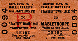
Station STAVELEY TOWN[Source: Josh Guest]
town_old1.jpg) Staveley Town station looking south from the footbridge linking the two platforms in 1952, shortly before closure. An LMS Hawkseye nameboard is seen on the left. From this bridge a similar inclined path led down to the platform. Staveley Town signal box is beyond the footbridge in the middle distance. Ireland Colliery is in the distance on the right.
Copyright photo from Stations UK. 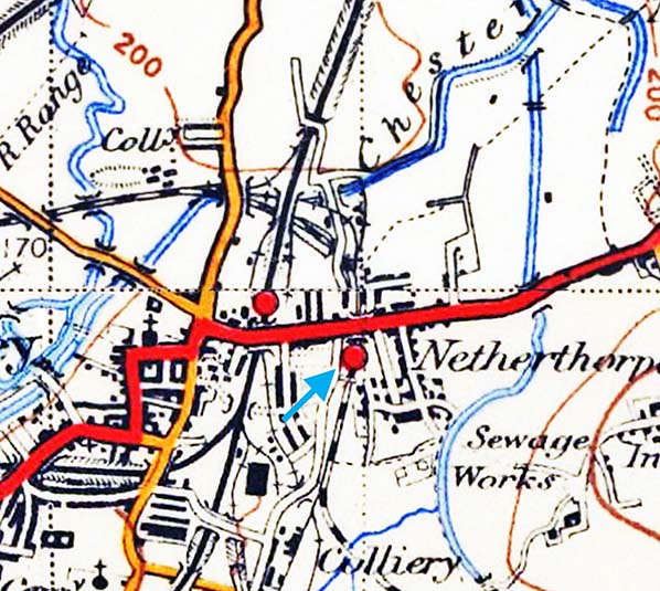
1960 1:2,500 OS Map. The station has been closed for 8 years by the time this map was published and the platform buildings and platforms have gone. The street level booking office is seen to the west of the cutting as is the site of the footbridge which gave access to the east platform. The ramp down to the platform is also clearly seen.
town_old2.jpg) The site of Staveley Town station looking south from Lowgates (A619) road bridge in October 1962. Although the station has only been closed for 10 years, coal traffic through the site remained heavy and evidence of the station has been largely removed. The west platform is largely obscured by the signal and undergrowth. The east platform has been substantially cut back. The ramp down is visible. In the foreground the piers forming the footbridge that linked the booking office with the platform are seen. Staveley Town signal box is beyond the footbridge seen in the distance.
Photo by MA King town_old6.jpg)
Looking north at the site of Staveley Town station from the footbridge lining Fan Road with Netherthorpe Close. Little evidence of the platforms is visible apart from the ramp down to the east platform which is clearly seen on the right.
Photo by John Mann town_old3.jpg)
In December 1969 the Staveley Town street level booking office in Fan road remained in good condition and leased to Barton & Gilling Domestic Appliances
Photo by MA King town_old4.jpg)
Staveley Town’s street level booking office in Fan Road in December 1969. The first door is the public entrance into the booking office. The gates to the left of the building are to the path down to the platforms so arriving passengers didn't have to walk through the booking office when leaving the station.
Photo by MA King town_old5.jpg) Staveley Town signal box seen from the Ireland Colliery sidings in December 1969. Staveley Town station is to the left.
Photo by MA King town_old)7.jpg)
Looking north from Netherthorpe Road footbridge at the site of Staveley Town station in October 2019. The mothballed track was finally lifted in 2016 when the line was sold to Derbyshire Country Council for conversion to Clowne Greenway. The work has yet to start here and the ballast still remains in place.
Photo
by MA King
town_old)6.jpg) Looking south from Netherthorpe Road footbridge in July 1973. Staveley Town station is behind the photographer with Staveley Town signal box on the left. Ireland Colliery sidings are on the right with Ireland Colliery in the distance on the right. Looking south from Netherthorpe Road footbridge in July 1973. Staveley Town station is behind the photographer with Staveley Town signal box on the left. Ireland Colliery sidings are on the right with Ireland Colliery in the distance on the right.Photo by MA King 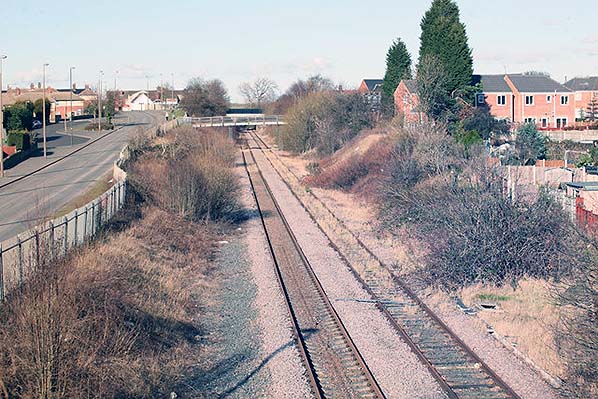 Looking north towards the site of Staveley Town station from the public footbridge across the former Ireland Colliery sidings in February 2012. The line has been mothballed since July 2006 following the end of coal traffic between Staveley and Creswell. Staveley Town station was between the Netherthorpe Road footbridge in the middle distance and the Lowgates road bridge, Looking north towards the site of Staveley Town station from the public footbridge across the former Ireland Colliery sidings in February 2012. The line has been mothballed since July 2006 following the end of coal traffic between Staveley and Creswell. Staveley Town station was between the Netherthorpe Road footbridge in the middle distance and the Lowgates road bridge,Photo
by Roger Geach, reproduced from Geograph under creative commons licence
Looking north from Netherthorpe Road footbridge at the site of Staveley Town station in October 2019. The mothballed track was finally lifted in 2016 when the line was sold to Derbyshire Country Council for conversion to a Clowne Greenway The work has yet to start here and the ballast still remains in place.
Photo by Andrew Tatlow, reproduced from Geograph under creative commons licence town2.jpg) Looking south from Lowgates bridge at the site of the west platform at Staveley Town in 2020. The track has been lifted but the ballast remains in place. The pipe is on the site of the footbridge that once linked the booking office with the east platform.
Photo by Josh Guest town4.jpg)
Looking north at the site of Steveley Town station from Netherthorpe Road footbridge in winter 2020. Lowgates road bridge is seen in the distance. Trees hide any remaining evidence of the platforms.
Photo
by Josh Guest
town5.jpg)
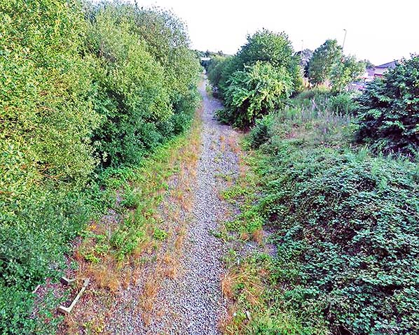
Looking north towards the site of Staveley Town station from the public footbridge that used to cross the Ireland Colliery sidings. After track lifting the ballast has yet to be lifted before conversion of the former trackbed into an extension to the Clowne Greenway, now a popular cycle route
Photo by Josh Guest town3.jpg)
|
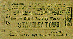
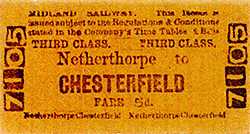 Notes: Staveley Town was a junction station, with a single platform, for services on the Clowne and Doe Lea Branch Lines. It was the second station to open after the neighbouring station of Barrow Hill. The station was located east of Staveley Central on the Great Central Main Line. It was opened on the line from Mansfield Woodhouse to Chesterfield on the North Midland Railway aka the 'Old Road' route. The station was located in a cutting under the A619 and the line was double tracked to the junction of both branch lines. However, it became single tracked after it on both branch lines respectively.
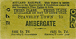 The station initially consisted of a single platform on the west side of the line. There was a street level booking office on Fan Road from where an inclined path led down the embankment to the platform where a waiting room and toilets were located. At some time, probably in the 1920s, the line through the station was doubled and a second platform with a crossover at its south end was added. This was reached by a footbridge from the booking office leading to another inclined path down the embankment. This platform was also provided with a waiting room and toilets. The station was one of three stations serving the mining town of Staveley. Staveley Central was on the adjacent Great Central line. It was also confusingly also called Staveley Town until renamed Staveley Central on 25 September 1950, less than two years before the Midland station closed. The thirds station was Staveley Works on the Great Central's Chesterfield Loop. Staveley Town never handed goods traffic.
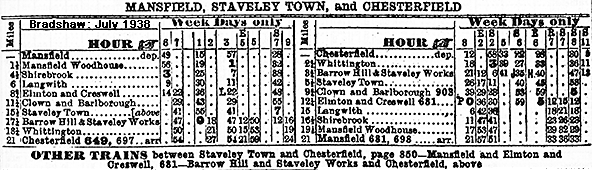
 The line between Staveley and Creswell was closed in July of 2006 following the closure of the line to coal traffic to an opencast mine near Staveley. The line was in situ until 2016, when Derbyshire County Council bought the line between Seymour Junction and Creswell to make it a greenway and it uses the whole line of the Clowne branch. It is protected for future use by railway.
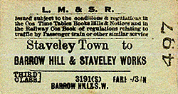
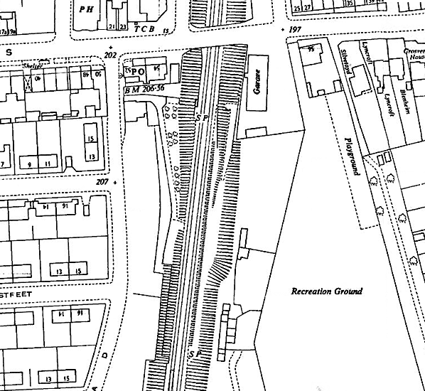
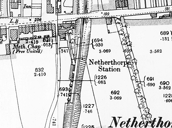 1898 1:2,500 OS Map. This map shows that the line through the station was originally single track with the station on the west side of the line. The booking office is in Fan Road and is seen opposite 831. A footpath runs from the road alongside the building and turns to the south where it runs down the side of the cutting to the platform. The platform is clearly shown as are two buildings which would have included a waiting room and toilets.
town6.jpg)

 Home Page