
Station Name: TOLLESBURY PIER[Source: Darren Kitson]
Tollesbury Pier Station: Gallery 1: 1907 - c1907  The station building in 1907, shortly after opening. This was the only building to this design on the Kelvedon & Tollesbury and the only one to have two doors, presumably as the interior was divided into two separate rooms although why this provision was considered necessary is not known. The man on the platform was possibly Mr Jack Gallant who was porter-in-charge at Tollesbury and also covered, along with his assistant, Pier station. The end of the line is to the right.
Photo from John Mann collection  
1923 1:2,500 OS map. Although the implication is otherwise, Tollesbury Pier station was closed by the time this map was published in 1923. Clearly seen is the path leading from the station, over the seawall onto the causeway and then the pier. The ramp between causeway and pier is also shown as are several of the drainage sluices and the extent of the mudflats. 'Saltings' are areas of land submerged during high tide and often including salt-tolerant (halophyte) vegetation. The peppered line upstream of the pier is a rock and/or shingle bank laid as a defence for the pier against strong ebb currents at times of high rainfall inland. Most commercial piers had a crane at their head but no confirmed details are known of that on Tollesbury Pier but we can surmise it would have been of no more than one ton capacity and of course hand operated.

1923 1:2,500 OS map. A similar but earlier map to that from 1923. At the station the permanent way hut is not shown and presumably because it was yet to appear but both grounded carriage bodies are present. The symbol for the railway track is that for a tramway, siding or light railway, the latter being applicable to the Kelvedon & Tollesbury of course.

This plan is of interest as it shows what could be termed the official demise of the Kelvedon & Tollesbury beyond Tolleshunt Knights (the end of the headshunt for Tudwick Road Siding). By necessity the plan was based upon an earlier map, hence why the railway track is shown still in situ. The coloured area around the station shows BTC (British Transport Commission) land while the reference to H.M. The Queen of 1954 refers to The Crown Estate. The 'Pier demolished [ ... ] closing of Branches File' of 1951 is a little curious as it is not clear if 'demolished' refers to the wartime breach or the destruction of what remained of the pier during the 1953 floods although given the mention of the Reconveyance of 1954 it is probably the latter. The destruction of the pier was however irrelevant in terms of the conveyance whereas boundaries were relevant. The Crown Estate, in very simple terms, manages estate on behalf of the Monarch for the nation. The Crown Estate owns most of the seabed around the United Kingdom out to the twelve mile limit and approximately half of the shoreline. 'Shoreline' is land between the high and low tide marks which is why The Crown Estate, given under the name of The Queen, was relevant to Tollesbury Pier. The history, portfolio and responsibilities of The Crown Estate are extremely complex and in-depth information is available via the internet.
 On the 1948 1:25,000 OS map 'L.N.E.R.' is a little out of date due to the map being a revision of an earlier edition. Tollesbury Pier station sat to the east of Mill Creek and behind the sea wall and having closed in 1921 it is of course not marked on the map. The track is correctly shown as being still in situ, it being lifted with the rest of the line beyond Tudwick Road Siding in about 1952. The Second World War breach in the pier is not shown and probably because, again, the map is revision of an earlier, pre-war, edition. 'Saltings' are areas of land submerged beneath salt water at high tide. The proliferation of Saltings gives an idea of what the area is like at high tide.

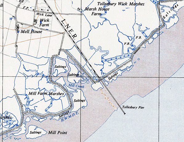
By 1958, the year of this 1:25,000 OS map, the abandoned course of the former railway is shown as 'Track of old Railway'. Tollesbury Pier is still marked on the map despite the actual pier having been destroyed in the floods of 1953. The feature which is shown is the causeway which led from the seawall to the pier proper. 'HWMMT' means 'High Water Mark at Maximum of Tide', the actual wording and therefore initials varying from map to map according to publication date but the meaning was the same. In 2024 the course of the former railway between Woodrolfe Farm Lane and along the eastern boundary of the Wycke Lane housing development, Tollesbury, to the site of Pier station is one of the very few still easily traceable sections of the former railway. Explorers should however note that much of the route south of Tollesbury village is now private property.

This photograph is something of a mystery. What remained of Tollesbury Pier in 1953 was largely destroyed by the East Coast flooding of that year so does this show the remains being removed or does it show the pier under construction? The debris at bottom left may suggest the former but the absence of decking and railings plus the lack of any obvious machinery which would be expected for the 1950s on the pontoon suggests the pier was under construction. The timbers, both on the section of pier and laying at bottom right, appear to be new. On balance therefore the pier was under construction circa 1905. If the ship in the distance could be identified it may be possible to date the scene beyond doubt but unfortunately the vessel is too far away.
Photo from Michael Prossor  It must have been rush hour at Tollesbury Pier station! Unfortunately details of the group of mainly women are lost in the mists of time. The man, for some reason with an arm raised, was possibly Jack Gallant the porter-in-charge at Tollesbury who oversaw pier station. Apart from during the very early days of Pier station, part of Mr Gallant's duties was to telegraph Tollesbury if any passengers were waiting at Pier. If no passengers and none were on the train for Pier, the train would not proceed beyond Tollesbury. Perhaps unsurprisingly very few photographs exist of Pier station when it was operational and as a result the bench seat is something of a mystery. Of what photographs do exist, one shows no bench present while others show a two-legged bench. While only two legs are visible here it does seem the bench was longer and therefore had three legs. If so the painted name probably announced
'PIER - STATION - TOLLESBURY''. Photo from John Mann collection 
A train approaches Pier station not long after the extension opened. Note that only one grounded carriage body existed at this time and the permanent way hut was yet to appear. This area was in the midst of a large swath of land which had been reclaimed in 1744 but it remained very marshy and still is today. The railway beyond Tollesbury Wick was therefore effectively on a causeway, the building of which may have been responsible for creating the pond in the foreground. The train is hauled by a GER Class R24, later LNER/BR Class J67, and is running as a 2-4-0T with the front coupling rods removed. This practice was quite common and not confined to the Kelvedon & Tollesbury. The train is of course formed of some of the 4-wheel stock originally converted for operation on the line ready for the opening as far as Tollesbury in 1904. The 1907 Pier extension did not, as far as is known, require any additional rolling stock.
Copyright photo from John Alsop collection 
A view towards the pier head from a dock steps landing, probably not long after opening judging by the condition of the wood. The photograph was taken at low tide and illustrates why the pier needed to be quite lengthy at 1,770 feet. Various sailing barges, yachts and small boats are present - a hint of the business the Great Eastern Railway hoped would develop but which never did.
Photo from John Mann collection 
A postcard view along Tollesbury pier towards the head with two sailors, two ladies and a child posing for the camera. Perhaps it was a family occasion. A man stands rather nonchalantly on the dock steps landing. Note the fire buckets, essential for wooden piers. The wood of the pier appears to be new, suggesting this photograph dates from soon after the pier opened.
Photo from John Mann collection
| ||||||||||||||||||||||||||
 Some confusion exists, not helped by misleading maps, about where Tollesbury Pier station was located and where the track actually ended. The station and end of the line were on land and the pier was merely a walkway. The idea was for the pier to attract the yachting fraternity who would use the pier and railway to travel inland to acquire provisions and/or simply tour around. The problem was by the time the extension opened on 15 May 1907 nearby ports such as Maldon were well established along with the facilities the town offered. Tollesbury Pier did however see limited steamer traffic with, for example the SS Annie calling if required. The Annie was a diminutive vessel designed for river cruises. Her career was chequered; after lying derelict at Osea Island during WWI she was refitted and renamed 'Maldon Annie', being transferred to the River Thames. She was supposedly one of the vessels which took part in the Dunkirk evacuation of 1940 but was lost. There may be some confusion with the vessel 'Maldon Annie IV' which was a motor vessel known to have been involved with the Dunkirk evacuation. The only other source of business at Tollesbury Pier was fishing, especially for oysters from the beds in the area. How much, if anything, of this trade was taken away by rail is unknown.
 The GER Way & Works Committee noted on 17 December 1908 that 'Tollesbury Pier' had cost £4,652 against an agreed budget of £5,300. In other words the project came in under budget. The problem here is the surviving GER Minutes being incomplete, not helped by Minute takers tending, understandably, to write in what could be called a form of shorthand. As a result we do not know if the £4,652 was literally for the pier or if it included the railway extension and Tollesbury Pier station. Looking at other costs involved with constructing the Kelvedon & Tollesbury the £4,652 was probably inclusive but, again, we do not know for certain.
 A Working Timetable from 1907 has been seen, this being the first to include the Pier extension, but it is damaged and as a result quite difficult to interpret. Nevertheless the gist of it can be extracted. A train departed Kelvedon at 6.59am which appears to have been a goods working with passenger cars attached as empty stock. This train eventually reached Tollesbury at 7.50am where the passenger cars were detached and taken forward to Tollesbury Pier, again as empty stock, at 8.5am arriving at 8.11am. The train then departed for Kelvedon at 8.18am in service. The next train was the 10.35am ex Kelvedon, reaching Pier at 11.28am. This was a mixed train which departed Pier for Kelvedon at 11.33am but as a passenger, as opposed to mixed, train. The next Down trains to run through to Pier were the 1.55pm and 5.40pm, both passenger as opposed to mixed trains. On Wednesdays and Fridays there was another Down train at 7.48pm, passenger, which returned from Pier at 8.33pm as a mixed train. In the Up direction, at what appears to be 2.40pm an empty passenger stock working departed Pier for Tollesbury, arriving 2.46pm. What this empty stock did after arrival at Tollesbury is puzzling but it appears they were attached to the 3.30pm ex Tollesbury Up goods train for return to Kelvedon. The 5.40pm passenger ex Kelvedon also returned from Pier as a mixed train. Given that Pier station only had a run-round loop, goods wagons could not be accommodated and indeed the station was never intended to be anything more than a passenger station. One may therefore question how mixed trains could run through to Pier. The answer is they didn't; goods wagons were detached at Tollesbury and only the passenger stock ran through to Pier with the reverse applying in the Up direction.
 As the 1908 public timetable above shows, all Down trains which were timed to run through to Pier did so only if required. If not required in the Down direction but passengers were waiting at Pier station, it is assumed the member of staff who spent the day at Pier would notify Tollesbury to send the train through. After all, it is highly unlikely passengers waiting at Pier would be told "Sorry, the train will not be coming". It will be noticed that the 2.45pm ex Kelvedon which arrived Tollesbury at 3.18pm had no balancing working. The stock would have returned to Kelvedon as empty stock and perhaps attached to a goods working but in the absence of a 1908 Working Timetable which method was used cannot be confirmed. The Pier extension must have been both a disappointment and an embarrassment to the Great Eastern Railway as it finally gave up and Tollesbury Pier station closed on 17 July 1921 and with it, apart from the loop at Tollesbury and wagon storage, the line beyond Tollesbury. Indeed had it not been for the First World War the Pier extension may well have closed prior to 1914. In fairness to the Great Eastern Railway, speculative ventures which saw railways either proposed or actually built in the hope of them triggering the growth of coastal resorts, and in some cases ports, were common and by no means confined to the Great Eastern.
 That, though, was not quiet the end. During WWII the area was taken over by the military as an anti invasion measure. The disused track beyond Tollesbury was made serviceable for use by military traffic and section of the pier at its landward end blown up to hinder an invasion force. One of many pillboxes in the area (and indeed across the country) was positioned near the land end of the pier. After the war the track from Tollesbury Pier station back to Tolleshunt Knights (the headshunt for Tudwick Road Siding) was lifted in the 1951 - 2 period following withdrawal of the passenger service and withdrawal of all traffic beyond Tudwick Road Siding. What then remained of Tollesbury Pier, which was 1,770ft long, 8ft wide and 50ft wide at its head, was destroyed during the floods of 1953. All that remain today are the rotting remains of a few wooden stumps projecting up from the mud. Beyond Tollesbury Wick crossing, the line crossed the marshes on a low embankment and today this embankment is one the very few obvious reminders on the ground of the railway ever existing.
 Home Page