
Station Name: TOLLESBURY PIER[Source: Darren Kitson]
Tollesbury Pier Station: Gallery 3
July 1933 - August 2023 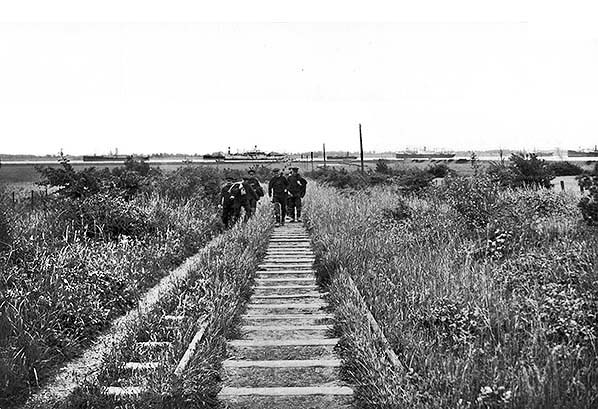 In July 1933 a group of what were probably barge skippers make their way towards Tollesbury on the footpath which the railway had become. There is actually a procession of people stretching all the way down to the pier. A number of laid up ships can be seen in the Blackwater. In July 1933 a group of what were probably barge skippers make their way towards Tollesbury on the footpath which the railway had become. There is actually a procession of people stretching all the way down to the pier. A number of laid up ships can be seen in the Blackwater.Copyright photo from John Alsop collection 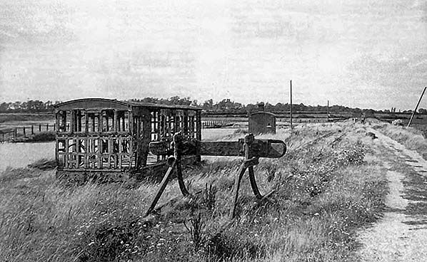
The desolate remains of Pier station in the 1930s. The pier was behind the camera. The platform and building had stood right of centre, in front of the leaning telegraph pole. Nature is doing its best to hide the track. The one remaining grounded carriage body has lost most of its panels, probably removed by persons unknown as there is no obvious evidence of panels having dropped off and laying on the ground. The skeletal body still served a purpose however, sheltering at least one bicycle. The permanent way hut either has something hanging on its end wall or has had a little hatch cut into it, although it is hard to understand what purpose the latter would serve. In the distance the trackbed can be seen rising on a 1:50 gradient, one of several 1:50 gradients on the Kelvedon & Tollesbury. Being a trundling light railway earthworks were kept to a minimum for cost reasons, which is why 1:50 gradients abounded along the line. In the right distance and immediately adjacent to the line, during World War Two a naval watchtower (also known locally as the 'Radar Tower') was erected. It survived and is today a holiday let, access to it being partially via the former railway trackbed.
Photo from John Mann collection 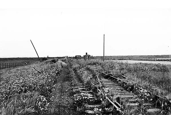
The site of Tollesbury Pier station on 18 May 1935 looking towards the pier. The sea wall runs left to right in the background. As can be seen, the points to the run-round loop were extant.
Copyright photo by HR Norman from John Alsop collection 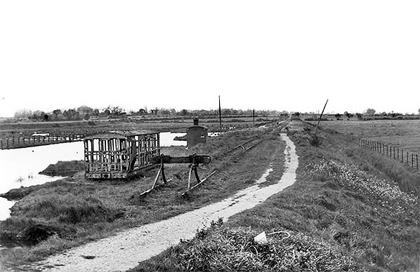 A further view from 18 May 1935 of what could be conveniently called 'the skeletal carriage body period', this one being taken from the sea wall. The points of the run-round loop are clearly visible. The footpath led from the station over the sea wall to the pier. By this time the carriage body was totally devoid of panels and the little hut appendage, thought to have been a toilet, had long since disappeared.
Copyright photo by HR Norman from John Alsop collection 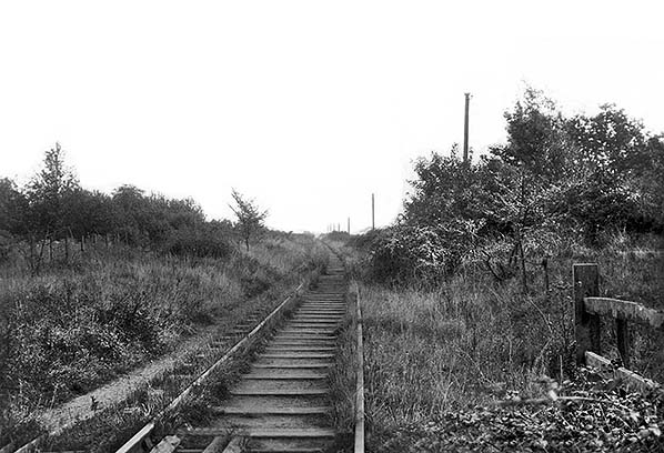
Looking towards Tollesbury Pier. The fence on the right and the cattle guards, or rather the remains of them, centre bottom tell us the photograph was taken from a level crossing. A little research reveals the location to be Woodrolfe Road crossing. Beyond the curve the line ran dead straight to Pier station. Clearly the four foot (the space between the rails) was a well used footpath with another along the Down side of the line. This will be another of the many photographs taken along this nominally disused section of line taken during the 1930s. This and the two above were postcards.
Copyright photo from John Alsop collection
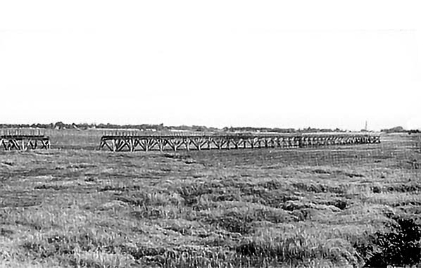
The section of pier removed during the Second World War as an anti-invasion measure with a few stumps of the removed section being visible. Sources vary being 1939 and 1940 regarding when this was done but it was most likely after the Fall of France in May - June 1940 which placed the enemy literally just across the English Channel. It was this advancement of the enemy which gave rise to Operation Dynamo, perhaps better known as the Dunkirk Evacuation. Hitler's invasion plans were found in Berlin by the Allies in 1945 and the initial seaborne landings would have occurred from Ramsgate around the south coast to Lyme Bay but the Brighton to Lyme Bay section was subsequently dropped due apparently to doubts about the ability of the Kriegsmarine to control that length of coastline. The Germans therefore had no plans to land at Tollesbury and indeed Tollesbury was, just, outside the area of the occupation zone as originally planned which was south of a line drawn between Maldon and Gloucester. Of course, the finer details of Hitler's invasion plan were not known at the time a section of Tollesbury Pier was removed. 'Anti-invasion' is something of a misnomer used as a convenient term and a little more detail is given in other image captions.
Photo from Jim Lake collection 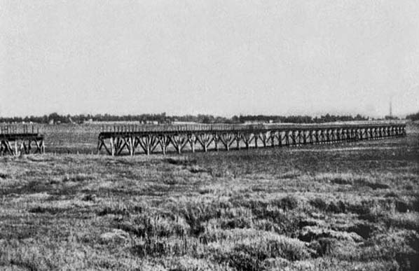
A further view of the removed section of the pier, this time at low tide. Both photographs showing the pier in this condition were likely taken just after the war. While by no means clear, the pier head also seems to have been removed. The horrific East Coast floods of 1953 were to destroy what by then remained of the pier, the wreckage being cleared away to leave just the stumps which
survive to this day. Photo from Jim Lake collection 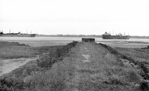 Looking along the causeway towards the site of the pier in 1962. Sleeper indentations are still just about discernible some ten years after the track was finally lifted. The World War Two pillbox was originally on the causeway but erosion, its own weight and by no means least the 1953 floods have seen it relocate itself onto the mudflats. It is described in more detail in other captions. Photo by Lorraine Duffy 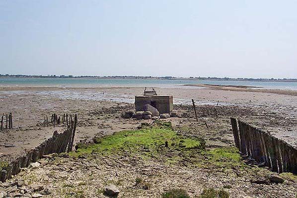
In this view from July 2005 the camera is looking along the alignment of the former pier. The stumps actually still exist for some distance into the river below the surface (this view was taken during low tide) and are still visible from the air. In the foreground it is very evident how the causeway has been washed away, leaving the pillbox to slowly sink into the mud. The wooden shuttering, left and right, was to protect the causeway from the water. Originally it was at the foot of the causeway embankment. Today at high tide the pillbox is partially submerged. 'Pillbox' is a universal nickname for what is properly termed an 'Infantry Blockhouse'. At one time people requiring tablets would go a chemist shop where the tablets would be made up by the chemist from ingredients held in stock. The completed tablets would then be handed to the customer in a little box, usually but not always circular and made from card which was often waxed to protect, one hoped, the contents from damp. It was from these little boxes that the nickname for these military structures was derived. The Tollesbury pier pillbox is to the irregular hexagon FW3/24 design, usually referred to more simply as 'Type 24'. They had seven loopholes, two in the rear wall which was the widest with one loophole either side of the entrance. The remaining five walls had one loophole each. Internally there was an anti ricochet wall; with Type 24 this was usually 'Y' shaped. Which weapons this particular pillbox was intended to accommodate is not known and could have been anything from the Lee-Enfield .303 to a light machine gun, for which latter gun mounts would have been fitted.
Photo
by Ron Strutt
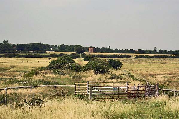
Looking from the sea wall over the site of Tollesbury Pier station in May 2005. The station was dead ahead, in the wider space between the bushes. In the distance the 1:50 gradient rising towards Tollesbury is evident while to its right stands the WWII naval watchtower aka 'The Radar Tower'. Some sources suggest the tower was used to control mines but this is not thought to be the case. A genuine Minefield Control Tower still exists at Burnham-on-Crouch and the 'minefield' was actually explosives detonated from the tower by electrical means. Click here for a close up view of The Radar Tower
Photo by Ron Strutt 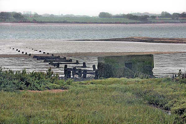
In this view of the pier remains at low tide in June 2020 it can be seen the pillbox is starting to disintegrate. Elsewhere was mentioned 'anti-invasion' measures and how the term is rather misleading. Breached piers, road blocks, anti tank obstacles, pillboxes and so on would not have prevented an invasion, instead the idea was to hinder the enemy and slow his advancement in order to give more time for defending reinforcements to arrive. The Home Guard, who usually manned pillboxes and the various obstacles, could not have done anything more and were arguably more useful patrolling, checking identities and so on. The BBC sitcom Dad's Army parodied the Home Guard but in reality it wasn't far removed from the truth. However it must be said that the men of the Home Guard 'did their bit' and they, the obstacles and the pillboxes were good for morale - a very important weapon in any conflict. Once morale is lost, a war is effectively lost. On a more gloomy note, the problem with pillboxes was that they would have been potential death traps for those inside them had the enemy landed and especially if the occupants were only armed with rifles. Thankfully insofar as Britain was concerned the death trap potential was never to be confirmed.
Photo by Anthony Whitehead 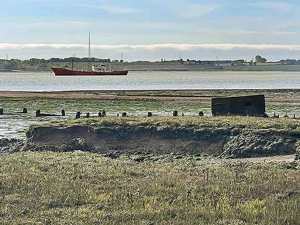 The subject of this photograph from around 2020 is the vessel at anchor in the river. She is the MV Ross Revenge, a former trawler which will be familiar to many people as the home of Radio Caroline. She had replaced the MV Mi Amigo, a former schooner which broke anchor and drifted onto Longsands Bank where she sank. In very shallow water, the wreck still lies at the site some fifteen miles east of Foulness. Some readers may wonder why Ross Revenge is not visible in other photographs of the pier remains and the answer can be found by looking at the stumps of the pier (with some cross bracing still present) which run roughly left to right across the scene. Ross Revenge is actually anchored a little further upstream and the pier ran on a south-easterly alignment, the camera is thereforeThe subject of this photograph from around 2020 is the vessel at anchor in the river. She is the MV Ross Revenge, a former trawler which will be familiar to many people as the home of Radio Caroline. She had replaced the MV Mi Amigo, a former schooner which broke anchor and drifted onto Longsands Bank where she sank. In very shallow water, the wreck still lies at the site some fifteen miles east of Foulness. Some readers may wonder why Ross Revenge is not visible in other photographs of the pier remains and the answer can be found by looking at the stumps of the pier (with some cross bracing still present) which run roughly left to right across the scene. Ross Revenge is actually anchored a little further upstream and the pier ran on a south-easterly alignment, the camera is therefore here facing due south. here facing due south.
Photo by Rob Wisdom 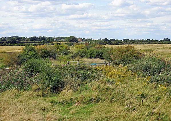
A similar view to that of May 2005, this time dating from August 2023. Nature has now engulfed the station site, which by this date had been closed for 102 years, as well as the foreground although some of this can be put down to the difference between May and August - Spring and Summer in other words. One wonders if any fragments of the grounded carriage body still exist in the bushes on the left, beyond the fencing. The course of the former railway remains fairly easy to trace over the section between Tolleshunt Knights and Tollesbury Pier but less so the Kelvedon - Tolleshunt Knights section. That said, looking at this scene anybody not 'in the know' would find it hard to believe a railway station, as basic as it was, ever existed here.
Photo
by Tom Bastin
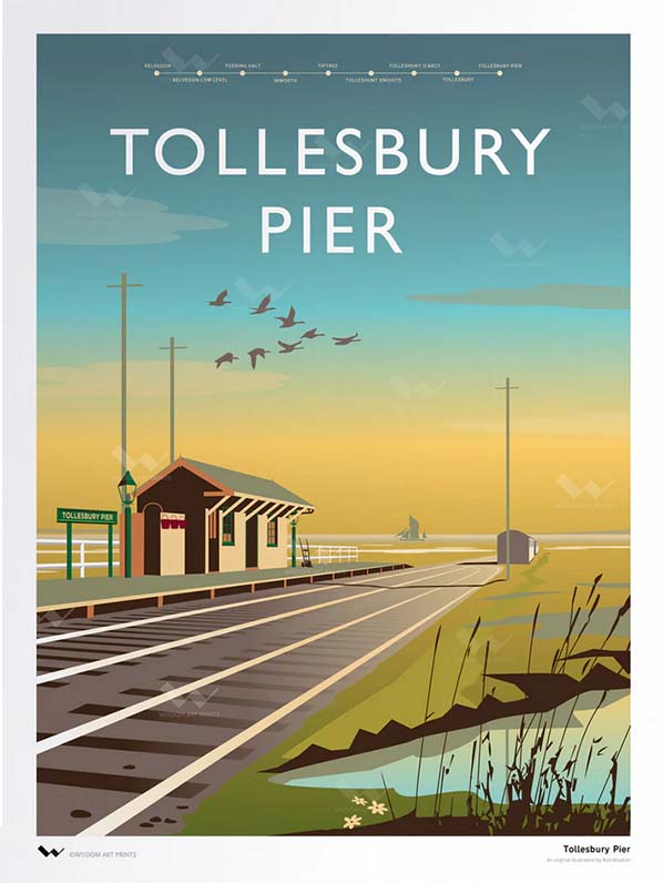
Wisdom Art Prints is a Tiptree based studio, illustrating and producing the highest quality greeting cards and art prints. Artist Robert Wisdom has been illustrating professionally for over 45 years. Robert has a particular interest in his local railway, the Kelvedon & Tollesbury Light Railway, and has illustrated all the stations
Print by Robert Wisdom
| ||

 Home Page