 Station Name: YARMOUTH SOUTH TOWN
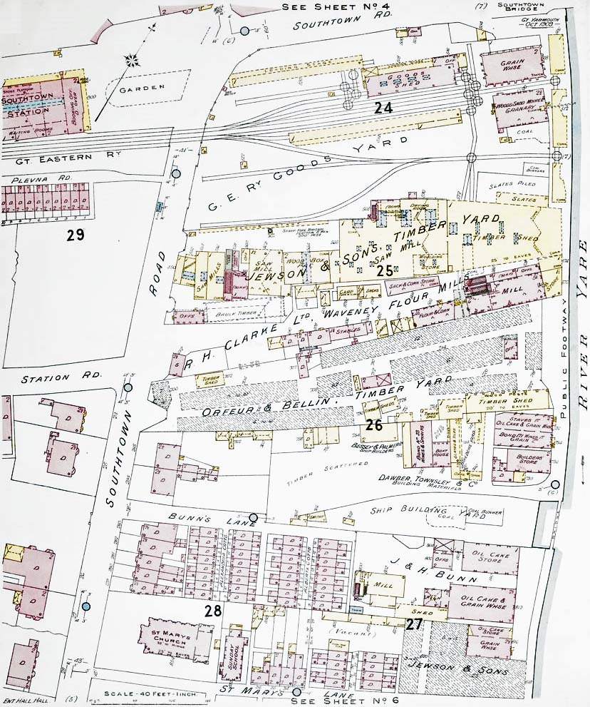 One of a series of 40ft to 1in plans produced by Charles E Goad in October 1909 for fire insurance purposes, in this case showing the area around South Town goods yard. Goad was a Canadian company which started out in 1875, opening a London office ten years later. Although not vastly different from any other map of the time certain labels, such as 'Slates Piled', 'Timber Scattered' and 'Vacant' represent the 'on the ground' situation at the time the survey was carried out and this is what differentiated insurance plans from standard maps. At top right, Haven Bridge is marked as 'Southtown Bridge' while notable by its absence is the electric tramway along Southtown Road. At top left, the station is spelled as one word and not as 'South Town' in the manner the railways always did. Clearly shown are the two tracks which passed along the south side of the station forecourt before crossing the road to enter the goods yard and, as mentioned in the text, these were the final lengths of track to remain in situ following closure. The awkwardness of the goods yard, being reliant upon numerous wagon turntables, is obvious. The yard saw several changes over the years and from surviving GER Records it appears the sidings disappearing into Jewson's timber shed began life as a single siding, whilst the aforementioned siding serving Jewson's loading stage was a later addition. Adjacent to the loading stage is marked 'Staff Fire Brigade', presumably a Jewson facility. South of the goods yard are numerous other industrial premises including a Ship Building Yard and another Jewson premises. These will have also used the GER goods yard but with cartage being used the short distance to and from but a good proportion of goods would have still been transported by water in 1909. Perhaps surprisingly, facilities for fish traffic appear to be absent, including the ice house (which was located adjacent to Haven Bridge). The reason for this was Yarmouth's fish traffic being mainly handled on the quays on the opposite side of the river which were served by the quayside tramway. There was, however, a smoking shed at some time and this did send out goods via South Town. At top left can be seen part of the passenger station. It shows the basic layout of the station building but is by no means well detailed. This is the only known surviving plan of the pre-1952 station building. British Railways’ plans from 1952 have, however, survived. Plan reproduced by kind permission of The British Library  Home Page Home Page
|