 Station Name: YARMOUTH SOUTH TOWN
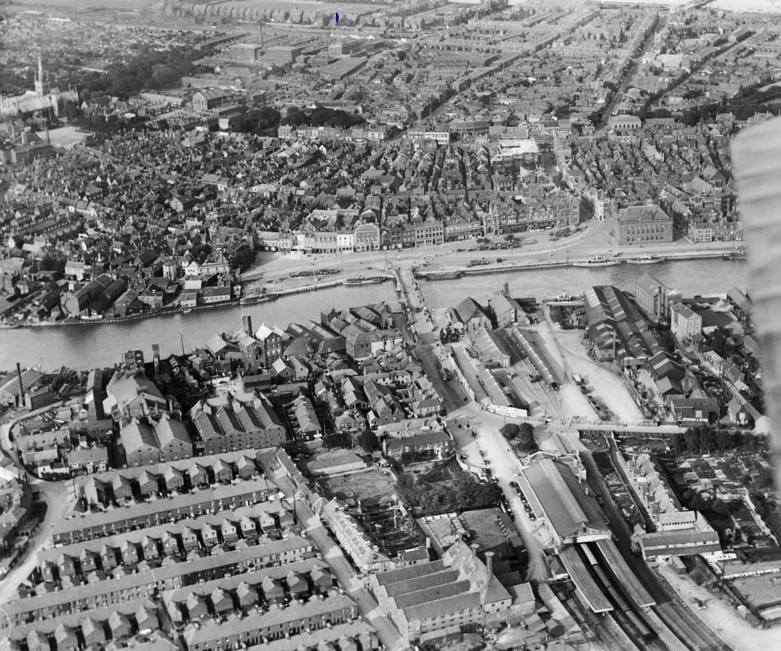 A June 1920 aerial view looking east across South Town station and goods yard. In the background can be seen Britannia Pier, one of two piers at Great Yarmouth, the other, Wellington Pier. The River Yare runs across the middle of the picture and Haven Bridge can be seen midway. West of the bridge runs Bridge Road which then turns left and becomes Southtown Road. On Bridge Road is a tram, seemingly departing for Gorleston. The tram terminus was directly in front of the bridge (see text). Although by no means clear, Haven Bridge at this time was still the narrow structure with wooden lifting section. On the opposite side of the river and to the right, the large building is Great Yarmouth Town Hall. At the bottom of the picture and right of centre is South Town station, its train shed hiding much of the station building from view. To the left of the station is the maltings and to its right the houses of Plevna Terrace, Station Road being further to the right. Between the station and the warehouse set at a right angle to Plevna Terrace ran the tracks leading to the level crossing and goods yard. The level crossing is just about discernible. Much more discernible is the station garden in the centre of the forecourt. In the north-east corner of the goods yard and near to Haven Bridge, the building which resembles a chapel is the ice house. The buildings west of and in line with the icehouse are the GER goods shed with a granary beyond and, on its north-west side, the loading bay. The building south of and adjacent to the icehouse is another granary. On the quayside and set parallel to the river were three other buildings, largely hidden from view in this picture. The open area in the middle of the site contained two sets of three sidings which fanned out east of the level crossing, one set being served by each of the two tracks which crossed the road and with both sets interconnected via wagon turntables within the goods yard. Roughly in the middle of the open area, what appears to be a train of vans is in fact another loading bay but precisely what was loaded or unloaded there is not recorded. The clutter of buildings at the south of the yard, i.e. on the right as we view, was the premises of Messrs Jewson. At the west end of Jewson's premises and butting-up to Southtown Road was a loading stage and the siding which served this can be discerned snaking its way across the open area. This siding could be reached only via a wagon turntable on a siding which ran north to south from the GER goods shed, via another such turntable, into Jewson's warehouses where it divided into two short stub-end sidings via the same turntable which gave access to Jewson's loading stage. Being shunted by horses originally, the goods yard would also have had stables at its disposal but the location of these has not been discovered. They may not necessarily have been in the goods yard but near the passenger station. South of Jewson's premises stand the Waveney Flour Mills of, then, Messrs Clarke. The GER provided a siding for Clarke but precisely where it was located has remained a mystery. In 2017 the icehouse still stands and is Grade II listed. Waveney Flour Mills are also still there and still operational, now producing Semolina.
Photo from Britain From Above with permission  Home Page Home Page
|