Notes: Bury Knowsley Street station was situated on the Lancashire & Yorkshire Railways (LYR) Liverpool, Bolton and Bury line. The line had been promoted by east Lancashire industrialists as the Liverpool & Bury Railway (L&BR). They wanted better access to the port of Liverpool so that they could bring in raw materials and export their goods more effectively. The L&BR was authorised on 31 July 1845 and work began shortly after. On 27 July 1846 the L&BR was absorbed into the Manchester & Leeds Railway (M&L). On 9 July 1847 a further Act authorised the building of a line between Bury and Heywood where there was a branch line of the M&L. That branch connected to the M&L main line at Castleton. The M&L had opened throughout on 1 March 1841, the Heywood branch having opened on 15 April 1841. The combined Acts created a route between Rochdale (via Castleton) and Liverpool. The M&L changed its name to the LYR as part of the 9 July 1847 Act.
 |
Bury Knowsley Street opened as simply Bury on 1 May 1848. The route from Heywood opened first. The route to Bolton and onwards to Liverpool opened on 20 November 1848.
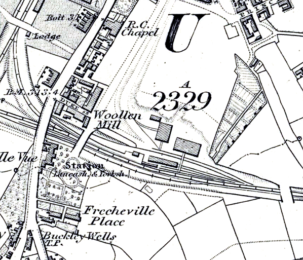
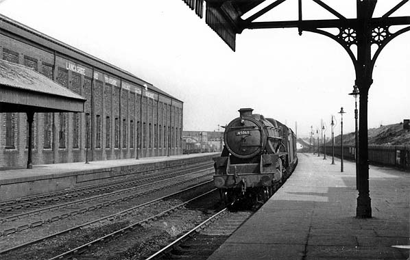
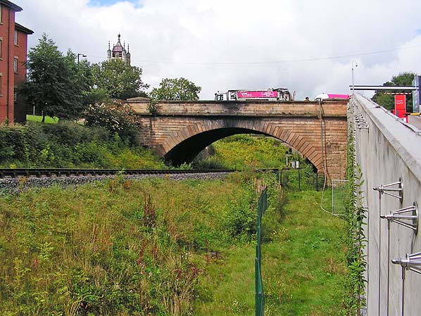
Bury LYR station was located on the east side of Knowsley Street to the south of the town centre; at the time of the station’s opening it was a short cul-de-sac called John Street but it was later extended southwards to join with Manchester Road and that is when it was renamed. The LYR line ran east/west through the town. The station was located in a cutting and Knowsley Street passed over the line on a single-arched sandstone bridge. A date stone located above the arch recorded the year 1848. A sloping driveway connected Knowsley Street to the station on the north side of the line. The main facilities were located on the up platform (Castleton direction) in a wooden station house that cost £240.
The station had two platforms. The down platform (Bolton direction) was an island. As well as having the down main line run along its northern face a goods line passed its southern face. In all four lines passed through the station: the up and down main lines and two goods lines. Passengers reached the down platform by crossing the line.
 Bury was an important manufacturing town so extensive goods facilities were provided at the station. They were located to the east of the passenger facilities, north of the line and consisted of a goods shed, a warehouse, four sidings and cattle facilities. Bury was an important manufacturing town so extensive goods facilities were provided at the station. They were located to the east of the passenger facilities, north of the line and consisted of a goods shed, a warehouse, four sidings and cattle facilities.
A short distance to the west the Manchester and Bury line of the East Lancashire Railway (ELR) passed over the LYR route. This line which had opened on 25 September 1846 ran north/south through the town at a similar elevation to the LYR. The Act authorising the Liverpool and Bury line had forbidden a flat crossing at Bury. For this reason the LYR line had to descend in order to pass under the LYR. This feature of the line became known as the ‘Bury Hollow’ or sometimes as the ‘hump’.
A link between the two systems, the Bury East Fork, opened at the same time as the route to Bolton on 20 November 1848. This tightly curved and steeply graded line branched off from the LYR line on the west side of the Knowsley Street bridge and curved towards the north passing under Manchester Street after which it had its junction with the ELR. The link allowed through trains of the two companies to run to and from destinations on their rival’s routes.
The ELR had its own station at Bury on Bolton Street.
In 1866 the station which eventually became Knowsley Street was renamed Bury Market Place in recognition of its position close to the town’s market.
In 1873 the LYR opened a signal box (Bury Junction Low Level) to control the junction between the main line and the Bury East Fork; it was located on the down side of the line between the Knowsley Street and the Market Street bridges. At the same time Bury Goods box was opened to the east of the station on the west side of the Market Street bridge; as its name suggests it controlled the connection between the Knowsley Street goods facilities and the main line. The box was equipped with a 20-lever frame.
 In 1880 Bury Goods signal box was renamed Bury Goods West. This was because another box, Bury Goods East, had opened; this box was renamed Bury East by 1884. In 1880 Bury Goods signal box was renamed Bury Goods West. This was because another box, Bury Goods East, had opened; this box was renamed Bury East by 1884.
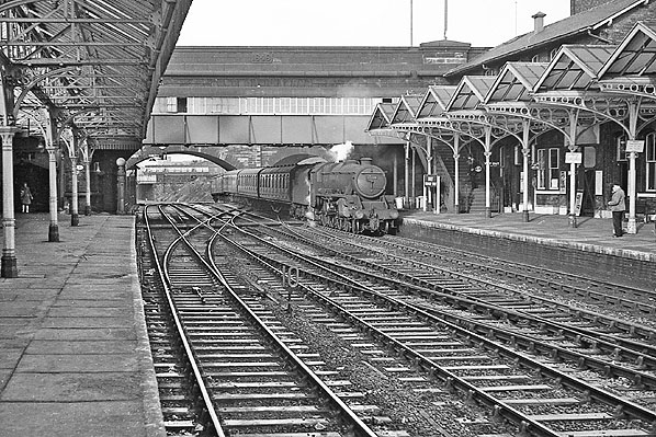
Over the years the facilities at Bury Knowsley Street had been enlarged in a piecemeal fashion. By 1880s this process proved inadequate and the station was remodelled and extended. One of the biggest changes was to the platform and track layout. A contract was awarded for the platform work on 22 April 1886 at a cost of £1,912 10s 1d. The down direction island platform was removed and it was replaced by a 160yd conventional platform set further back from the up platform and it was of greater height than the original one.
Four tracks were laid between the up and the down platforms. Adjacent to the down platform was the down slow line. Then came the down fast line followed by the up fast line, both of which were through lines having no platforms. Finally there was the up slow line. The four-track section extended from a point just west of Manchester Street bridge, at Bury West, to a point xx mile to the east of the station, at Bury East.
The up platform was also extended to 230yd and increased in height. At its eastern end it had a bay which extended for 70yd.
A covered entrance was provided on Knowsley Street. It consisted of a single-storey red-brick structure with three semicircular-arched openings springing from a stone string course, the northern opening being the entrance whilst the other two were windows. The roof was pitched and of slate construction with cresting on the ridge tiles.
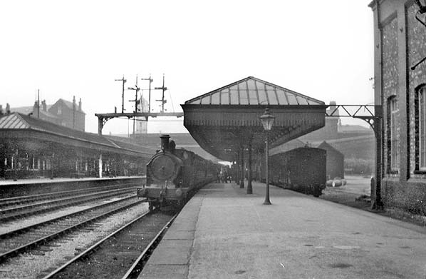
A wide, covered staircase led from the entrance building to the first floor of a two-storey building that was located at the west end of the up platform. It was a somewhat austere red-brick structure abutting the bridge, with segmental-arched openings and a pitched slate roof. On the first floor there was a refreshment kiosk and the station booking office. There was also a further flight of stairs that linked to platform level. At ground level there were station offices and store rooms.
 Adjacent to the two-storey building there was a long single-storey building contained waiting rooms. The style of roof and segmental-arched openings were in the manner of its neighbour, but some interest was given by the series of gables that faced the platform to correspond to the ridges and furrows of the canopy. Adjacent to the two-storey building there was a long single-storey building contained waiting rooms. The style of roof and segmental-arched openings were in the manner of its neighbour, but some interest was given by the series of gables that faced the platform to correspond to the ridges and furrows of the canopy.
Waiting facilities, a W H Smith’s bookstall and toilets were also provided on the down platform. They were located in a nondescript single-storey brick building under a hipped roof.
Glazed platform canopies were provided during the 1886 rebuild. They were of a lively ridge-and-furrow style, supported by a series of iron columns from which extended large brackets with circular shapes within the spandrels. The gables of the ridges were boarded or glazed and a deep valance was provided, but in later years these materials were removed.
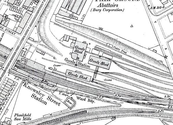
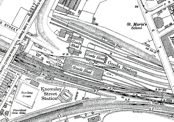
The goods facilities were also enlarged with additional sidings and new sheds being erected.
In 1888 the station was renamed Bury Knowsley Street. In 1891 the Bury Junction Low Level signal box was renamed Bury West (click here to see photos and maps).
Because of the increasing volumes of traffic passing through the station in November 1893 a further contract was let to J Kirkbride for a footbridge and waiting rooms. The contract was worth £1,950. The footbridge was located at the western end of the station next to the Knowsley Street bridge and extended from the booking hall to the down platform. It was 72 ft long and was provided with a roof and sides. Covered stairways connected to the up and the down platforms.
In 1898 Bury East signal box was closed and replaced with a brick-based LYR Size 13 structure equipped with a 64-lever LYR frame. The new box was located between the up and down lines to the west of the Market Street bridge (click here to see a map and a photo of the box).
Further enhancements were made to the station through a contract let to R Neill on 26 April 1899. At a cost of £2,006 the canopies of both platforms were extended eastwards. The extensions were of a simpler pitched design with hipped ends and plain valances.
On 11 July 1899 a new connecting line between Bury Knowsley Street and the former ELR was opened. Known as the Bury Loop Line it branched off from the main line at a point ½ mile to the east of the station, at what became Bury Loop Junction. A signal box had opened at Bury Loop Junction in 1898. It replaced Bury Goods East dating from 1880. Bury Loop Junction signal box was located between the up and the down main lines to the east of the Heywood Street bridge, ½ mile from Knowsley Street station. It was a brick-based LYR structure fitted with an LYR 44-lever frame (later extended to 48 levers). (Click here to see a map and a photo of the box). The Bury Loop line ran parallel to the original route for a short distance before curving to the south-west and passing behind the down platform. It continued to curve towards the south-west passing under Manchester Street in a 70yd covered way after which it connected to the former ELR at Loco Junction. This new line was for freight services.
In 1909 the LYR replaced the 1873 Bury West signal box. The new box was still on the down side of the line but to the west of the Market Street bridge. It was an all-timber LYR Size 10 box containing a rear-mounted LYR frame of 48 levers (click here to see a map and a photo of the box).
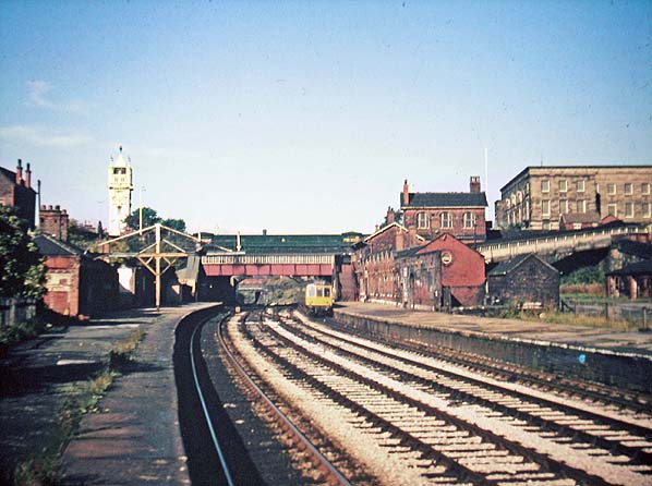
 In 1912 the LYR improved the goods facilities at Knowsley Street once again. The most notable change was the erection of a large cotton warehouse at a cost of £5,448 adjacent to the up platform bay towards the eastern end of the station. It was of red-brick construction with a series of windows set in the lower part of the building and brick pilasters between each of them. The new warehouse was equipped with a 40-ton electric travelling crane. In 1912 the LYR improved the goods facilities at Knowsley Street once again. The most notable change was the erection of a large cotton warehouse at a cost of £5,448 adjacent to the up platform bay towards the eastern end of the station. It was of red-brick construction with a series of windows set in the lower part of the building and brick pilasters between each of them. The new warehouse was equipped with a 40-ton electric travelling crane.
On 1 January 1922 the LYR merged with the London & North Western Railway and a year later that company became part of the London Midland & Scottish Railway (LMS).
At nationalisation on 1 January 1948 Bury Knowsley Street became part of British Railways (BR) London Midland Region (LMR). The new owners painted the station in 1949. Alone among the BR regions the LMR provided ‘totem’ station name signs quickly and cheaply by printing them on paper posters, and this station is one of the locations where they were displayed. After 1957 conventional vitreous enamel totems and running-in nameboards were fitted together with other miscellaneous signs. The modernisation of signage was not accompanied by improved lighting; gas lamps continued to be used (of Sugg design which replaced casements, probably late in the LMS era).
At 4.40pm on 19 January 1952 there was a catastrophic collapse of the footbridge. There were 200 passengers returning from a football match on it at the time and two were killed. Over 170 people were injured, 43 of them having to be admitted to hospital. An investigation found that iron fastenings had corroded and wooden beams had rotted. Inadequate inspections had failed to identify the danger and so it had collapsed (click here to read a detailed account of the collapse). A replacement footbridge was erected in March 1953.
The Reshaping of British Railways (‘Beeching Report’) of 1963 did not list the Bolton – Castleton line for closure but it was listed in the section 2 Appendix as being a line on which services were to be ‘modified’. In August 1964 the line was moved into the closure list and BR(LMR) announced its intention to close Bury Knowsley Street station to passenger services from 4 January 1965. Local opposition prevented the closure and the train services then operating were reprieved in September 1966.
 Bury Loop Junction signal box was destroyed by fire on 27 March 1967. To save the expense of rebuilding it BR(LMR) closed the Bury Loop Line completely. The box was abolished on the day of the fire and officially closed on 15 April 1967. Bury Loop Junction signal box was destroyed by fire on 27 March 1967. To save the expense of rebuilding it BR(LMR) closed the Bury Loop Line completely. The box was abolished on the day of the fire and officially closed on 15 April 1967.
The goods facilities at Bury had always been very busy and in 1967 they still employed 50 people. In May 1967 BR announced that Knowsley Street was to close to goods services. Alternative facilities were to be made available at Bolton. The goods facilities closed on 5 June 1967.
On 12 December 1968 BR(LMR) once again published a proposal to withdraw all passenger services from the line and once again local people vigorously objected.
Bury East signal box closed on 8 June 1969 and the up and the down fast lines were taken out of use.
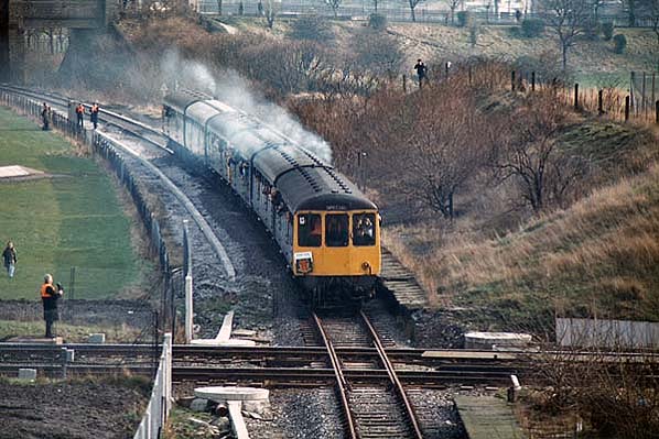
In September 1969 Bury Knowsley Street became an unstaffed station as did the others on the line. Tickets were to be purchased on the trains. Already neglected by this time, the withdrawal of station staff sent the station into terminal decline. Click here to read about the last few months at Bury Knowsley Street and the events that followed.
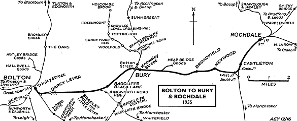
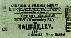
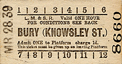
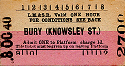
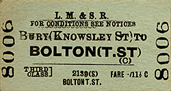
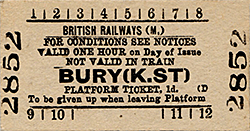
Tickets from Michael Stewart and route map by Alan Young. Thanks also to Tony Graham for sharing his research notes.
Click here to read about passenger train services
Sources:
- A Regional History of the Railways of Great Britain - Volume 10 The North West - Geoffrey O Holt, David & Charles 1986.
- Forgotten Railways - North West England - John Marshall, David & Charles 1981.
- Lost Stations of North West England - Paul Wright, Silverlink Publishing 2011.
- Signal boxes on Lancashire & Yorkshire Railway lines: north and west of Manchester - Chris Littleworth,
LYRS, 2014
- The Lancashire & Rorkshire Railway, Volume 1 - John Marshall, David & Charles 1969.
- The Lancashire & Yorkshire Railway Volume 2 - John Marshall, David & Charles 1970.
See also: Bury Bolton Street
Click here to see the other stations between Bolton and Castleton:
Darcy Lever, Bradley Fold,
Radcliffe Black Lane, Heap Bridge Goods, Broadfield,
Heywood (2nd) and Heywood (1st) |


 Home Page