| Notes: The West Midlands Railway (WMR) was formed on 14 June 1860 with the union of the Oxford, Worcester & Wolverhampton Railway (OW&WR) the Newport, Abergavenny & Hereford Railway (NA&HR)
and the Worcester & Hereford Railway.
On 17 July 1862 the WMR Additional Works Act authorised the construction of two branches radiating from Old Hill. The first was to run in a northerly direction to Blowers Green Junction, near Dudley, and connect with the GWR’s Stourbridge Junction to Wolverhampton Low Level line. The second would run south to Halesowen with an end-on connection with the proposed Halesowen & Bromsgrove Branch Railway (HB&BR). On 1 August 1863 the WMR was amalgamated with the GWR: a shrewd move by the GWR as it would deny the LNWR access via Smethwick to Stourbridge and allow direct access to Birmingham. In the 1860s any trains from the Stourbridge direction for Birmingham had to travel via Dudley and reverse at Wolverhampton Low Level, substantially increasing the journey time.
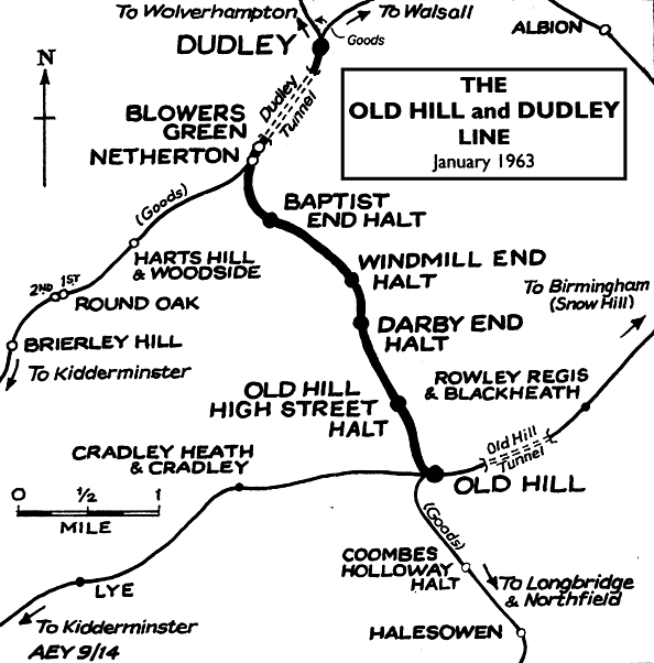
The Old Hill to Blowers Green line, or the ‘Bumble Hole’ line as it was christened, was opened on 1 March 1878 by the GWR. The line became known as the Bumble Hole line as it passed through an area of that name close to Windmill End. Construction of the line had not been easy as the route took in heavily industrialised areas and would have to cross the Dudley Canal near Windmill End. 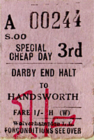 Expenditure on bridges and earthworks to by-pass many of the mining activities was vast and would have probably bankrupted an independent company. Expenditure on bridges and earthworks to by-pass many of the mining activities was vast and would have probably bankrupted an independent company.
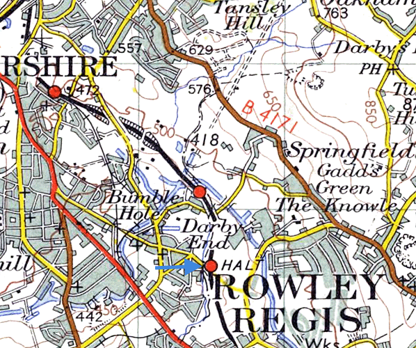
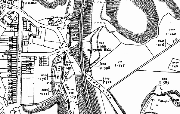
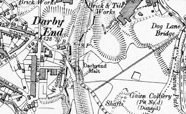
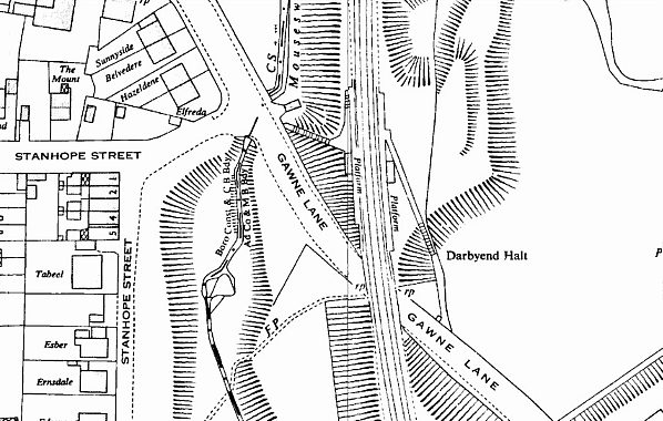
Darby End Halt was a later addition to the line, opening on 21 August 1905, with the GWR attempting to counter the threat of local omnibuses. The station stood on an embankment directly north of Gawne Lane, with a large established housing area to the west. Following normal Bradshaw practice, for many years the halt was acknowledged only as a footnote in the public timetable, which between Old Hill and Dudley included only Windmill End (prior to its demotion to a halt) and Dudley (South Side) in the ‘station bank’.
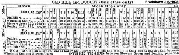
The halt comprised two wooden platforms capable of taking short trains, with a rudimentary waiting shelter being provided on both platforms. The platforms were constructed using old sleepers as supports and decking giving a very rough platform surface and appearance, with the platform shelters being of wooden frame construction clad in corrugated iron with a hipped 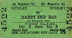 corrugated iron roof of concave profile (popularly described as a GWR ‘Pagoda’ shelter). The roofs of the original shelters were subsequently replaced with a pitched corrugated iron roof due to extensive corrosion. Access to the down (Dudley direction) platform was via a short flight of steps opposite the junction between Gawne Lane and Stanhope Street. The up platform was reached from the opposite side of the overbridge on Gawne Lane and involved a steep flight of steps and ramp from road to platform level. Bradshaw’s July 1922 timetable shows there were 17 down (Old Hill to Dudley) and 20 up services calling at the halts along the line on Monday-to- Saturday with no Sunday service. The timetable also notes the line is operated by ‘Motor Cars of one class only’. corrugated iron roof of concave profile (popularly described as a GWR ‘Pagoda’ shelter). The roofs of the original shelters were subsequently replaced with a pitched corrugated iron roof due to extensive corrosion. Access to the down (Dudley direction) platform was via a short flight of steps opposite the junction between Gawne Lane and Stanhope Street. The up platform was reached from the opposite side of the overbridge on Gawne Lane and involved a steep flight of steps and ramp from road to platform level. Bradshaw’s July 1922 timetable shows there were 17 down (Old Hill to Dudley) and 20 up services calling at the halts along the line on Monday-to- Saturday with no Sunday service. The timetable also notes the line is operated by ‘Motor Cars of one class only’.
The line was renowned for its poor riding qualities owing to extensive mining activities in the area and the subsidence this caused. Passenger loadings along the line were never high enough to warrant anything more than the provision of a single GWR rail-motor or a Collet/Pannier tank engine and a single coach.
At the time of the Grouping, 1 January 1923, the line came under the control of the GWR and services continued much as they had for the previous 25 years. With nationalisation of the railways on 1 January 1948 the line fell under the control of British Railways Western Region who decided that the halts along it would require rebuilding, so from 1957 through to 1960 the halts from Old 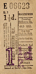 Hill High Street to Baptist End, inclusive, were rebuilt. At Darby End the wooden platform supports and surface were replaced with pre-cast concrete. The waiting shelters were rebuilt with pre-cast concrete supports clad with corrugated iron partially enclosed but giving little protection from the elements; a roof-cum-canopy projected over the platform. Oil lighting was also replaced with electric and totems were attached to the lighting columns, allowing the dilapidated GWR running-in boards to be removed. Hill High Street to Baptist End, inclusive, were rebuilt. At Darby End the wooden platform supports and surface were replaced with pre-cast concrete. The waiting shelters were rebuilt with pre-cast concrete supports clad with corrugated iron partially enclosed but giving little protection from the elements; a roof-cum-canopy projected over the platform. Oil lighting was also replaced with electric and totems were attached to the lighting columns, allowing the dilapidated GWR running-in boards to be removed.
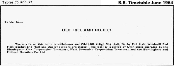
A major revision of British Railways regional boundaries took place on 1 January 1963 when the Bumble Hole line was transferred to the London Midland Region (LMR). The ‘Beeching Report’ of March 1963 sounded the death knell for the passenger service with its withdrawal being recommended. As seen on other recently transferred lines in the area, the LMR had no sentimental attachment to former GWR routes. The official proposal to close the line was published on 2 August 1963 and on 30 April 1964 the Secretary of State for Transport gave his consent. The final service was scheduled for Saturday 13 June 1964, a little over a year after the initial recommendation, and the official date of closure was 15 June. Some stations along the line saw as little as one passenger a day. It is quite surprising that the station at Darby End was little used as it was within easy walking distance from the houses located to the west and was well served in both directions.
In June 1964, the Wolverhampton Express & Star prepared an obituary of the Bumble Hole line passenger service.
Not many will mourn its passing, except maybe for pangs of nostalgia. It has had its day. But in the past there is no doubt that it provided a greater service for the community.
The paper went on to quote Guard Bishop of the 6.30pm from Dudley.
If we get one passenger on this particular train, that’s as many as we’ll ever get. We may get him twice a week and he usually gets off at Windmill End.
BR (LMR) prepared its own black bordered obituary for the line:-
Following the withdrawal of the passenger services, goods trains continued to use the line. Near Baptist End there was a junction to the Netherton Goods (formerly Withymoor basin branch until 1 August 1921) but this branch closed on 5 July 1965. The sparse remaining traffic lingered until 1 January 1968 when the line officially closed, the track being lifted shortly after.
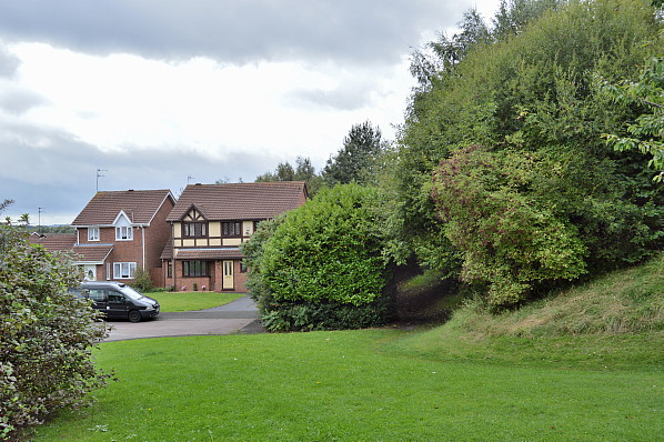
Today the location of the station site is difficult to find as the embankment to the south of the station has been completely levelled. The remaining embankment section on which the station stood has been practically levelled, developed with some housing and enclosed within a wooded area. No trace of the station or the access remains.
Tickets from Michael Stewart, route map by Alan Young and Totem from Richard Furness.
Sources:
- Bradshaw's July 1922 Railway Guide - David & Charles 1985
- By Rail to Halesowen - Michael Hale & Ned Williams - Michael Hale Publishing 1974
- Forgotten Railways: Volume 10 The West Midlands - Rex Christiansen - David St John Thomas Publisher 1985
- A Regional History of the Railways of Great Britain - Volume 7 The West Midlands - Rex Christiansen - David St John Thomas Publisher 1995
- Lost Lines Birmingham & the Black Country - Nigel Welbourn - Ian Allan Publishing - 2002
-
To see stations along the Bumble Hole click on the staiton name:
Old Hill High Street Halt , Windmill End Halt , & Baptist End Halt
See also:
Old Hill, Netherton, Blowers Green & Dudley
|

end_halt_old2.jpg)

end_halt_old6.jpg)
end_halt_old7.jpg) A great close up view of the building on the Dudley direction platfom in 1957. Corrosion of the walls of the building is evident with the roof having been replaced some years earlier due to the same problem. The cast iron GWR notice to the right of the window is certainly worthy of note and the terraced housing of Gill Street can be seen in the background.
A great close up view of the building on the Dudley direction platfom in 1957. Corrosion of the walls of the building is evident with the roof having been replaced some years earlier due to the same problem. The cast iron GWR notice to the right of the window is certainly worthy of note and the terraced housing of Gill Street can be seen in the background.end_halt_old4.jpg) Looking north from the top of the entrance steps at the rear of the Old Hill direction platform building in 1957. The rudimentary buildings and platforms were to be shortly swept away and replaced.
Looking north from the top of the entrance steps at the rear of the Old Hill direction platform building in 1957. The rudimentary buildings and platforms were to be shortly swept away and replaced.end_halt_old5.jpg)
end_halt_old3.jpg)
end_halt_old8.jpg)
end_halt_old1.JPG)
end_halt_old9.jpg)
1.jpg)
2.jpg)

_close_290814.jpg)

 Home Page