Station Name: EXNING ROAD HALT [Source:
Darren Kitson]
road_old1.jpg) This is one of a number of photographs of Exning Road Halt which exist but which are unfortunately undated. This appears to be a fairly early view, perhaps 1930s, as everything is neat and tidy. The nameboard is in good order and in later years it had become very shabby. There is one notice board on the bridge wing; later there were two. The photographer is standing in Cambridgeshire and immediately beyond the bridge is Suffolk. Quite why the GER did not provide simple wooden platforms of a proper height, instead of tolerating the ongoing expense of converting rolling stock to suit the halts, is something of a mystery. Remember that from 1922 the 6-wheel conductor-guard stock conversions were quite drastic and by no means involved only the provision of retractable steps. Over a period of 18 years some 40 of the 6-wheelers were converted - hardly a cheap solution and at a time when the GER was very economy-minded.
Copyright photo from Tony Harden collection  
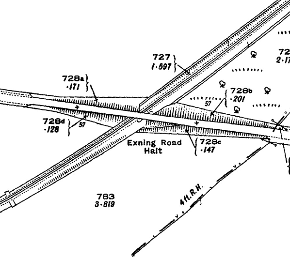
Exning Road Halt on a 1927 1:2500 map. Burwell is to the west on both road and railway while the road to the east eventually comes to Exning and then Newmarket. Apart from nearby Burwell, the only other evidence of human life in the area of the halt was a couple of cottages and a farm along the road towards Exning. Like all the halts, Exning Road is sited on the up side of the road. No platform is indicated here but the steep path down from Newmarket road is seen.
road_old3.jpg) Exning Road Halt viewed from a Mildenhall-bound train on 5 October 1957. The elevated position affords a good view of the access path down the embankment. The nameboard is beginning to look just a tad shabby and two notice boards are in position on the bridge wing - not that there were ever many passengers to read them. An enlargement of this image suggests that the notice on the left gives timetable details among other information. To the right of the metal sign, which either warns against trespass or advises it readers to 'Beware of Trains', is what appears to be the oil lamp casement lying on the ground. Given the month and the service level at this time, the lamp would be out of use. The portable steps have yet to appear, but their arrival is imminent as Gresley brake thirds were due to be introduced and not all of these vehicles were fitted with retractable steps. The train is the 10.23am ex-Cambridge, the locomotive is tender-cab J15 No.65438 and the stock comprises a Gresley composite, from which the photograph is taken, and an ex-GER brake third. This same train was photographed on its return to Cambridge departing from Burwell. See the page covering that station.
Copyright photo by R M Casserley road_old2.jpg)
Exning Road Halt looking towards Burwell. The date is unknown but examination of the finer details, such as the condition of the nameboard, suggests that it was taken around the time of closure. Lighting conditions have made the image somewhat deceiving; the cinder 'platform' appears to be raised, but in fact it is flat, and by this time had all but weathered away leaving the sleeper facing standing proud.
Copyright photo from Tony Harden collection
road_old4.jpg)
Looking towards Fordham we see Exning Road Halt on 16 June 1962, the final day of the passenger service. There is no sign of the portable steps or the oil lamp, although in June the lamp would not be required. The poster boards on the bridge wing have also vanished. As explained on the Fen Ditton Halt page, the suggestion that Tilley lamps replaced the wick lamps at the halts is open to question. Above the nameboard the gate at the top of the access path can be seen, while the path itself appears to be quite grassed over. This is not surprising given that the halt saw little use. In the right background another of the diamond-shaped road signs, as described on the Burwell page, can be seen. Also on the right the chimneystacks of the nearby cottages are visible above the road. Burwell was within walking distance to the left but the cottages and a farm were the only habitations near the halt. On the extreme left the cast iron plate bearing the bridge number, 2242, is seen.
Photo by David Pearson road1.jpg)
The site of Exning Road Halt in the late 1960s. The only remaining evidence of the halt from this angle is the old sleepers which formed the facing to the ground level cinder 'platform'. Even the bridge identification plate has been removed. The relatively clear trackbed at this point might be explained by a higher level of oil contamination in the ground as a result of forty years of trains slowing and stopping at the halt. Track-lifting, apart from the Fordham - Burwell section on which the halt stood, had commenced in March 1965 following withdrawal of the goods train over the entire branch in July of the previous year. The Fordham - Burwell section closed for good on 16 April 1965 (the day of the final train) and track-lifting of this section simply continued as an 'add on' to the original contract. As a result, Exning Road Halt was trackless within weeks of the final train on the Fordham - Burwell section. BR had, however, commenced dismantling everything bar the track the day following the final passenger train back in 1962.
Copyright photo from Tony Harden collection road2.jpg) The site of the halt in the late 1960s looking towards Burwell. The sleeper facing to the ground level cinder 'platform' remains visible on the left of the trackbed. There is evidence of the bridge beginning to deteriorate, but nevertheless it was to stand for another thirty years before being declared dangerous, and infilled.
Copyright photo from Tony Harden collection road3.jpg) Newmarket Road bridge in the late 1960s. A 1965 Ford Anglia, complete with perambulator undercarriage on its roof, is seen on the brow. Percy Shaw's 'Cat's Eyes' make sure motorists stay on the correct side of the road as they cross the bridge in this view looking towards Burwell. On the left is the gate at the top of path leading down the embankment to the halt while more of our old friends, the posts made from redundant sleepers, can be seen.
Copyright photo from Tony Harden collection road4.jpg) A close-up view of the site of the halt in July 1969 looking towards Burwell. Obviously summer, the undergrowth is flourishing and the sleeper 'platform' facing is only just visible towards the bottom right of the image. Photo by John Mann road5.jpg) A July 1969 close-up view of the gate at the top of the embankment assault course. When comparing this view to that showing the Ford Anglia, the gate appears to have gained a further degree of dilapidation. Note the period bicycle with its comfortable coil-spring saddle, proper rear mudguard, plastic handlebar grips and obligatory wicker basket. One suspects the bicycle conveyed the photographer to the location. The sturdy fencing around the gate was necessary not just for public boundary purposes but also to prevent people from falling down the side of the embankment. Fencing continued down one side of the footpath to track level for the same reasons. On the left, the trackbed can be seen curving towards Burwell station, out of sight beyond the belt of trees, while on the right and in the distance some houses at the south-east corner of Burwell village can just be seen - probably on Isaacson Road which then had only a scattering of houses. Since the railway closed a further, small, estate has been built between Isaacson Road and the site of the halt, which now lies only a quarter of a mile from the edge of Burwell village.
Photo by John Mann road10.jpg) The site of Exning Road Halt looking west towards Fordham in 1975.
Photo by David Burrows from his Flickr photostream road7.jpg)
An August 2008 view from the top of the infilled bridge and looking towards Cambridge. Burwell station was behind the trees in the right background. The dark patch, or cropmark, curving away across the field marks the course of the railway which was in a shallow cutting. Exning Road Halt was in the grassed area towards the left of the image. Border Bridge was infilled c2000 as its condition had become a cause for concern and crash barriers now mark the site of its parapets. The overhead power lines are visible in other images but the pole which once stood on the up side of the railway has vanished. Contrary to popular belief, this area is not in the Fens which lie to the north. The ground here is on chalk while a mile or so to the east is the start of the heathlands for which the Newmarket area is well known.
Photo
by Tony Lewis reproduced from Geograph under creative commons licence
road6.jpg)
Looking towards Burwell along the B1103 in August 2008, the site of the former bridge over the railway is very obvious. The gap in the hedge on the left was not the entrance to the halt; this was further up the gradient. One may well ask the obvious question of why the halt entrances were not located at, as it were, ground level, thereby avoiding the need for precarious paths cut into embankment sides. The answer is because the railway predated the halts and property boundaries established, a ground level entrance would involve a path being laid parallel to the embankment on private land, which would have necessitated the purchase of land from the adjoining landowner plus all the associated legal costs.
Photo by Tony Lewis reproduced from Geograph under creative commons licence road9.jpg)
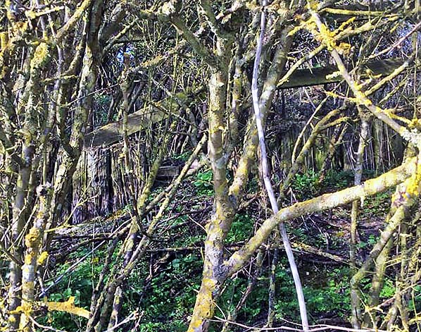
Looking north-west at the site of Exning Road Halt in May 2015. A slight lowering of the hedge alongside the road marks the position of the demolished parapet; a car is seen crossing the infilled bridge. The platform was in the centre of the picture with the path down the embankment where
the taller bush is seen. Photo by Nick Catford 
Top of access path from road to the platform in March 2021.
Photo by Paul Dewey
|
 The Great Eastern Railway opened Exning Road Halt on 20 November 1922; one of three halts opened on that day in an attempt to attract extra revenue in the face of increasing road competition. This was during a period of economy measures being implemented along the Mildenhall branch, so the GER must be given credit for looking at ways of increasing revenue rather than merely settling for cost-cutting initiatives. However, until DMUs and railbuses appeared on the branch a large number of hauled coaches were converted over a period of time to serve the halts and in view of the cost of this it is doubtful whether the three halts ever justified themselves. Details of the rolling stock converted to serve the halts can be found in the
 Back in the boardroom, the GER was inviting tenders for construction of the Mildenhall branch. With Royal Assent having been received on 18 July 1881, the relevant Act provided for three sections of railway: Barnwell - Swaffham Prior; Swaffham Prior - Fordham; Fordham - Mildenhall. Henry Lovatt, of Wolverhampton, won the contract for the entire route with his tender of £76,327 11s 8d. During October 1882 the contractor moved in to peg-out the course of the line, and on a cold and miserable Wednesday 3 January 1883 some GER grandees and Mr Allix assembled at – unsurprisingly - Swaffham Prior for the usual 'cutting of the first sod' ceremony. During 1883 the signalling contract was awarded to Messrs McKenzie & Holland with signal boxes costing £75 10s each, while local tradesmen were recruited for the erection of station buildings. The station building at Swaffham Prior was built in a somewhat different style from the others in order to mirror the design of Swaffham Prior House.
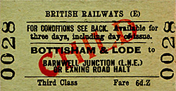
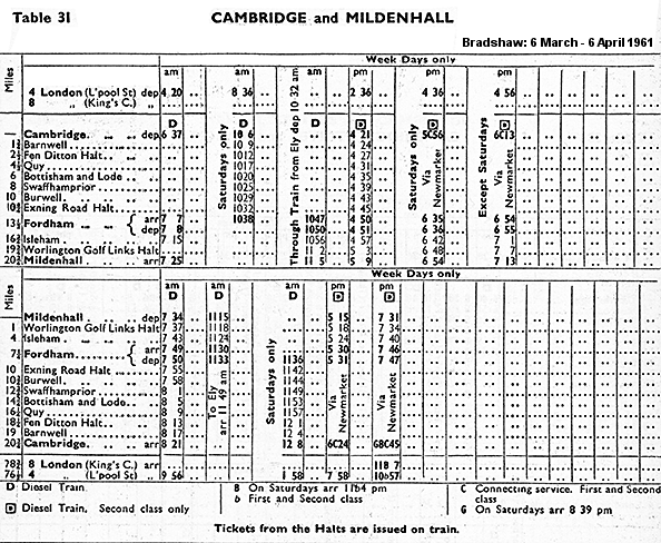
 The Railways Act of 1921 saw the GER become part of the London & North Eastern Railway (LNER) on 1 January 1923. On this date Mildenhall Golf Links Halt was renamed Worlington Golf Links Halt. The ‘Halt’ suffix appeared in timetables and on tickets but not on the halt nameboards. As the halts had no proper platforms, the GER introduced carriages fitted with retractable steps. Initial conversions were of increasingly antiquated 6-wheeled stock. Because the halts lacked booking facilities the GER introduced ‘conductor-guard’ working, and for this purpose the carriage stock had to be modified to allow the guard to move through the train. Tickets from Quy were also issued on the train.

 Home Page