.jpg)
Dundalk Road bridge looking south on 30 October 2012.
Photo by Paul Wright
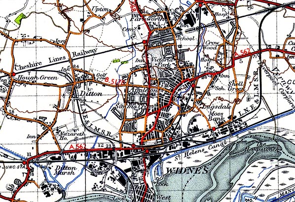
The GC & MR Joint Railway - Widnes Branch can clearly be seen on this map from the 1930s. The Cheshire Lines Railway can be seen running from west to east at the top of the map. Branching off it and running through Widnes is the Widnes Branch which is labelled on this map as the LNE & LMSR line. It passed to those companies at the grouping in 1923.
THE ROUTE OF THE LINE DESCRIBED
From the east the GCR/MR Joint Railway Widnes Branch started at Widnes East Junction on the CLC main line. The junction was west of a road overbridge that carried the line over Derby Road. The junction was controlled by a signal box. The first box at this location opened on 17 April 1878, but was replaced on 1 November 1891 with a CLC type CL19 box. This box was in turn replaced on 8 April 1956 with a British Railways LM15 box with a thirty-lever frame. All three boxes were located south of the line, to the east of the actual junction. From Widnes East Junction the joint line curved towards the south, straightening at the point where, until 1880, the west-facing chord had branched off. The junction was called Widnes South, and it had been controlled by a signal box which existed from 20 April 1878 until 31 January 1910. It then ran straight ahead, passing under a sandstone bridge where Dans Road crossed the line. The trackbed to the north of Dans Road bridge was part of the Sunny Bank Park in 2012.
Mileposts (Miles From Widnes East Junction) |
Grid Reference (twelve figure) |
Description of location |
MP1 |
353678,386410 |
Approximately half way between Dans Road bridge and Johnson’s Crossing. |
MP2 |
352807,385353 |
South of Moss Bank Road east of Tanhouse Lane Station. Adjacent to east side of Golden Bowl Signal Box. |
MP3 |
351235,384961 |
East of the Victoria Road bridge. |
MP4 |
349889,385655 |
South of Dundalk Road |
MP5 |
348912,386548 |
Adjacent to Hough Green Junction |
To the south of Dans Road a straight section of line continued southwards as far as the level crossing at Johnsons Lane. A signal box controlled the crossing in early years but it had closed by 1910. After the crossing it curved westwards until it reached Moss Bank Road to which it ran parallel, heading west. Originally there was a crossing at the eastern end of Moss Bank Road which carried Moss Lane over the line. The Moss Lane crossing was called ‘Sullivans Crossing’ as it provided access into the works of that name. The crossing was controlled by the Sullivans Level Crossing signal box. The original box had existed from the opening of the line but was replaced on 22 May 1938 with a ground frame. Industry developed rapidly in the Moss Bank area after the line opened. Sidings led into the various factories along this section of line including the large Sullivan Chemical works, to the south. To the north of the line were houses and a pub - the Golden Bowl Hotel. Sections of the line between Dans Road and Moss Bank could still be discerned in 2012 but much had been lost. In 2012 one very small section near the site of the Johnsons Lane crossing retained rails, which were laid in the late 1960s as part of the Fiddlers Ferry power station loop, used by trains bringing coal to the plant.
At the western end of Moss Bank Lane was Tanhouse Crossing. On the east side of the crossing was Tanhouse Lane station which had opened on 1 September 1890. Tanhouse Crossing was controlled by Tanhouse Lane signal box between 1890 and 6 December 1964. It was located on the north side of the line, west of the crossing. Just west of the box, also on the northern side, was the two-road Tanhouse Lane engine shed, with a turntable to its west. West of the engine shed was Tanhouse Lane yard, with sidings on both sides of the main line. The goods shed was towards the western end of the yard, south of the main line. To the south of the yard was the large Pilkington works and to the north the Cornubia works, both served by the railway. The western end of the yard had been the terminus of the line between 1877 and 1879. When the section from Tanhouse yard to Hough Green opened on 1 July 1879, West End Goods signal box opened at this location. It was replaced on 2 September 1912 with Widnes West box at the same location to the north of the line, and it survived until 1937. A small section of the line at Tanhouse Lane goods yard survived as Moss Bank Park in 2012.
From the western end of Tanhouse yard the joint line crossed a brick viaduct that carried it through the Newtown area of Widnes. At Ann Street it crossed over the 1833 St Helens and Runcorn Gap Railway on a metal bridge before reaching a further brick viaduct. It then passed onto an embankment which carried the line over Victoria Road on a metal bridge flanked with short sections of brick viaduct in the centre of Widnes, before entering Widnes Central station, which opened on 1 August 1879.
After Widnes Central the line continued west, passing over Lowerhouse Lane on another metal bridge, after which it reached Moor Lane Junction where a branch headed south to the Widnes Dock Estate. Controlling the junction with the branch was Moor Lane Junction signal box. From 1907 the box was a GCR type GC5 with a 24-lever frame. It closed with the line on 6 December 1964. All traces of the line between the west end of Tanhouse yard and Moor Lane had been lost by 2012.
After Moor Lane Junction the line headed north-west before turning sharply north. It then entered a cutting and passed under a brick bridge where Dundalk Road crossed the line. The cutting became deeper, and the line ran into Liverpool Road tunnel. On leaving the tunnel, in a deep cutting, it turned westwards and continued to the CLC main line at Hough Green. In early days there was a branch line to a quarry at Liverpool Road, a little west of Hough Green Junction. It was out of use by early 1891. Ditton Quarry Junction signal box had controlled movements on and off the quarry branch.
Hough Green Junction was originally controlled by a CLC box which opened on 15 May 1879. It was replaced in 1960 with a British Railways 30-lever frame LM15 box. Just west of the junction was Hough Green station. A short section of the line between a point just to the south of Dundalk Road and immediately to the north of the Liverpool Road tunnel survived as a linear green space in 2012, although the tunnel had been infilled in 1975.
.jpg)
Looking east towards Tanhouse Lane yard from an eastbound train that was just coming off the Ann Street viaduct in 1964.
Photo by Neville Conroy
|


 Home Page