Station Name: LONGDON ROAD[Source: Darren Kitson]
Longdon Road Station: Gallery 1
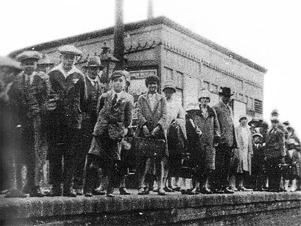
c1920 - Before 1947  Nothing is known about this photograph other than it depicting passengers awaiting an excursion to Weston-super-Mare. Looking at the attire, the period would be circa 1920. Not one of the personages there present and regardless of age is without a hat or cap. This was an age when being seen in public without some form of headgear was just not the done thing. Excursion trains, other than railtours for railway enthusiasts, did not normally traverse the Shipston-on-Stour branch and instead excursion passengers were conveyed by the normal branch passenger train to Moreton-in-Marsh. One would assume excursion passengers also boarded at Shipston-on-Stour and Stretton-on-Fosse so the usual single passenger carriage was probably supplemented
Photo from John Mann collection  
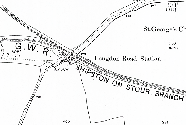
The 1902 OS map showing Longdon Road station. The 1889 chord curves away southwards while the original horse tramway is seen curving away north-westwards towards Ilmington and Stratford-upon-Avon. This northern section of the tramway is thought to have been last used circa 1904 by the occasional wagon load from Newbold Limeworks to Longdon Road. The map shows a physical junction between tramway and railway but whether this existed in reality is unclear; if it did, then presumably part of the tramway had been re-laid with bullhead rail but probably only as far as Newbold Wharf, north of which, (photographs suggest) the original 'fish belly' rail on stone block sleepers remained until the line was dismantled circa 1918. On the platform just one building can be seen, the wooden waiting room, roughly midway along the platform.
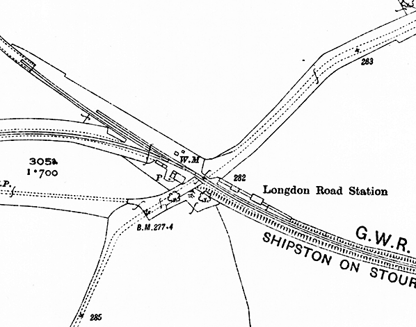
 By the time of this OS map of 1923 several changes are apparent. The tramway towards Ilmington and Stratford-upon-Avon has been lifted to leave a siding which was to remain until 1947. The second siding appears unchanged; the weighbridge and its small wooden office have now appeared. On the platform, the corrugated iron parcels lock-up has appeared between the waiting room and level crossing.
road_old4.jpg)
Facing towards Stretton-on-Fosse, this view perhaps dates from around the time the passenger service was withdrawn in 1929. Unfortunately the chalked notice propped against the station building is totally unreadable. One wonders if it gave details of alternative travel arrangements following the withdrawal of the passenger service. A platform trolley stands beside the corrugated iron lock-up and beneath the running-in board is what looks like a drinking water can. Railway cottages at this time and indeed for many years afterwards were frequently not connected to mains services and drinking water was brought by train in cans such as that seen here. A full can, or two, would be dropped off and empties collected for refilling and this cycle would be repeated at intervals. Three oil lamps can be seen, two on the platform and one by the entrance to the station beside the level crossing. Behind this lamp can be seen the small hut which did duty as the goods yard weigh office.
Photo from John Mann collection road_old5.jpg) Longdon Road facing towards Shipston-on-Stour, undated by probably shortly after withdrawal of the passenger service by which time the station was staffed by a single Leading Porter. The running-in board is still in situ but no platform lighting can be seen. Just visible to the right of the telegraph pole is a milepost announcing 98 miles 34 chains, measured from Paddington. Working Timetables gave it as 98 miles 35 chains. Whether one was an error or the milepost had been replaced and at a different location for some reason is not known.
Photo from John Mann collection road_old15.jpg) Another view towards Stretton-on-Fosse and likely taken in April 1933. The two oil lamps nearest the camera have been partially dismantled, leaving just the frames of the casements atop their posts. Perhaps not immediately obvious is that the platform was wider at the level crossing end than at the Shipston end. This was done to accommodate the platform buildings and gave the impression of a short bay at the Shipston end. No such bay ever existed, however.
Photo from John Mann collection road_old8.jpg)
Another view from April 1933, this time showing Mr. C. R. Clinker standing at the foot of the platform ramp. Charles Clinker (1906 - 1983) was the author of "Clinker's Register of Closed Passenger Stations and Goods Depots, 1830-1977". The occasion was an, apparently, walking tour of the line with Mr Clinker accompanied by D. S. Barrie, C. L. Mowatt and C. F. Klapper. This photograph was likely taken by the latter. Mr Clinker's papers are now held at Brunel University Library, Uxbridge.
Copyrigh photo from John Alsop collection road_old7.jpg)
In all likelihood this is another view from April 1933 during the visit by Mr Clinker and his group. Certainly it is after closure to passengers as only two oil lamps remain intact on the platform. We have a relatively better view of the cables used to alter the goods loading gauge to suit GWR or LMS gauging. The cable coming down from near the top of the post toward bottom right of the photograph is a guy cable, the mechanism for adjusting the loading gauge being near the bottom of the post and not visible here. The milepost mentioned in another caption is still present of course and can be discerned between the loading gauge and telegraph pole. The sign at the bottom of the photograph appears to be quite new but it's purpose is unclear. It may have borne the date of track relaying; there was another such sign, albeit to a different design, on the west side of the level crossing.
Photo from John Mann collection road_old6.jpg)
Looking towards Moreton-in-Marsh on an unknown date sometime after total closure in 1941, all platform lighting having been removed and the running-in board having long gone. In the left background the weight office hut still stands which tells us the date is prior to 1952 by which year the platform buildings had also disappeared.
Photo from John Mann collection road_old16.jpg) This rather splendid view is looking west towards the goods yard with the steeply graded 1889 connection towards Moreton-in-Marsh curving away to the left. Despite the rusted appearance of the railheads at the bottom of the picture, the branch was still in use by goods trains and the photograph may have been taken leaning from the brake van at the rear of such a train. The elevation appears a little too high for it to have been taken from the end of the platform, which was ramped. We have decent views of the horse landing with its somewhat peculiar fencing and of the small wooden weigh office to the right. Horses were led over the crossing to the right of the landing and out through the double gate on the right. The open gate in the foreground was the public entrance to the passenger station. Of the two goods sidings, that on the left was on the track bed of the original horse tramway and ended abruptly, with no buffer stop, at the rather mysterious gate in the background. ‘Mysterious’ because it served no obvious purpose and ordinarily one might expect a permanent fence to have been in place. The line of trees running left to right in the background, left of centre, was the course of the horse tramway on its direct route south from Ilminster to Moreton-in-Marsh. Behind the cottage was a permanent way hut, adjacent to which was a ground frame for the siding point work. Point rodding is present but appears to be disconnected, suggesting that this photograph dates from between 1941 when Longdon Road closed to goods and therefore all traffic, and 1947 when the sidings were lifted. The sign over and right of the level crossing was the usual trespass warning. The GWR used several types of such signage including cast iron but the wording of all was very similar if not identical. Signs like that seen here were enamelled, with white lettering on a blue background. Some, such as this example were vertically orientated and others were horizontally orientated. Numerous examples survive, turning up at ‘railwayana’ auctions from time to time and it is interesting to note there are variations to punctuation which suggests that the lettering was applied by hand. Note the narrowness of the road over the level crossing, the scene being very different today. The two cast iron gate posts on the other side of the road survive as of 2024, but the gate and its posts nearest the camera were eventually recovered by the heritage Gloucestershire & Warwickshire Railway and believed to have been installed at Toddington. Click here to see a large version.
Copyright photo from John Alsop collection Click here for Longdon Road Station: Gallery 2
3 August 1952 - December 2016
|


 Photographs taken in the 1917 - 1918 period survive however, showing that the original tramway track remained until the end, at least on the section north of Darlingscott Junction. By applying something resembling logic therefore, it seems likely after 1889 that goods were trans-shipped at Longdon Road to and from horse drawn tramway wagons. If so it would have been a very clumsy affair, time consuming and labour intensive. There is also the matter of the GWR considering a steam railmotor service to Stratford-upon-Avon but no evidence has been found of any track relaying in connection with this. The GWR is known to have inspected the tramway in connection with the railmotor idea but that was as far as it got before the railmotor idea was quietly dropped. As an aside, the 1892 Kelly's Directory for Worcestershire, Page 14, noted that the horse tramway was disused in 1891, making reference to the Stratford-upon-Avon to Shipston-on-Stour section but with relevance to the section through Alderminster.
 Longdon Road railway station was provided with a normal height platform east of the level crossing and on the Down side of the line. The platform, on a curve, was around 170ft long which appears to have been the approximately standard platform length on the Shipston-on-Stour branch excluding Moreton-in-Marsh, or ’Moreton-in-the-Marsh’ as it was then commonly but erroneously called. The platform was oil lit and remained so for its entire life. The station building was the usual, for this line, external frame wooden affair with flat roof sloping towards the rear. Apart from the construction method, all three such buildings on the Shipston-on-Stour branch differed in detail. West of the level crossing was a small goods yard complete with weighbridge and a diminutive wooden hut as the weigh office. The level crossing was given proper railway type swing gates and a keeper's cottage was provided (this is sometimes described as a Stationmaster's house). The goods yard, such as it was, contained two sidings of which one was laid directly on the alignment of the former horse tramway with the second shorter siding being to its north side. These had been re-laid in 1917 and again in 1924, on both occasions with second-hand rails no longer fit for use on main lines - common practice on branch lines. Some, at least, of these second-hand rails were inside keyed. The siding that laid directly on the former tramway alignment ended abruptly, without a buffer stop, at a somewhat mysterious gate across the former tramway trackbed. The reason for this odd arrangement is unclear, though at the time the siding was installed, the tramway track had yet to be lifted so one might assume the gate marked the boundary between tramway and railway despite the whole system being owned by the GWR. Horse drawn wagons arriving from the Alderminster direction were, perhaps, required to stop at the gate and await instructions. Whatever the reason, lifting of the tramway track was the reason for the abrupt ending of the railway siding; the increasingly decrepit gate remained in situ for many years afterwards.
 ongdon Road was also provided with a goods loading gauge of the standard GWR adjustable type. There was nothing unusual about that except that the gauge was positioned over the running line. The reason for this was possibly the points leading to the goods sidings being too close to the level crossing, leaving no option other than to position the gauge east of the level crossing over the running line. Due to the points trailing in the Down (towards Shipston) direction, the branch goods train would drop off and/or collect any wagons at Longdon Road on its way to Shipston-on-Stour. Collected wagons would then be taken forward to Shipston and then to Moreton-in-Marsh on the return trip. This operational necessity was normal anywhere in the country where single-ended sidings were present.
 Home Page