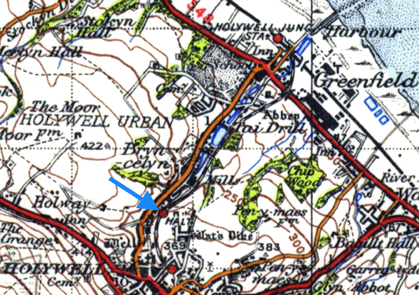
Notes: St Winefride’s Halt was located on the 1¾-mile Holywell Town branch which connected to the Chester and Holyhead main line at Holywell Junction (Holywell until 1 July 1912). The line was opened by the London & North Western Railway on 1 July 1912. There were just two stations on the branch the other being the southern terminus at Holywell Town.
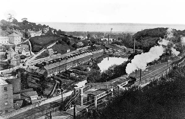
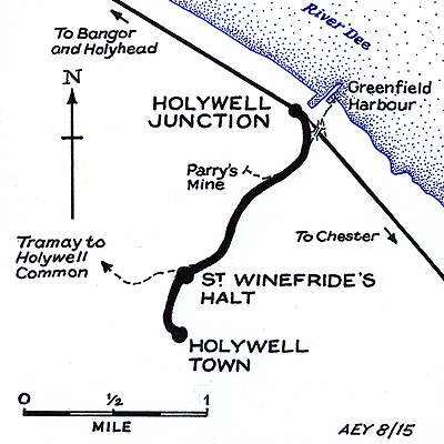 Much of the course of the branch had previously been part of the Holywell Railway (HR) which had opened in 1867 (along the route of an existing tramway). The HR had provided a link between an industrial area to the north of Holywell and a harbour at Greenfield on the River Dee. By the late 1870s many of the industries had ceased and consequently the railway went into receivership, as a result of which the line closed and was lifted. The HR route was purchased by the LNWR in 1891. For many years the company debated what should be done with it and even considered an electric tramway. In 1905, having previously operated a steam lorry service between the main line station and the town, the LNWR introduced a motor bus service between Holywell Junction and Holywell Town. It was a success and encouraged the LNWR to obtain an Act to reopen the HR. New sections of line were built between the old alignment and Holywell Junction station and between St Winefride’s and Holywell Town. It was built as a single-track railway with no passing loops. Much of the course of the branch had previously been part of the Holywell Railway (HR) which had opened in 1867 (along the route of an existing tramway). The HR had provided a link between an industrial area to the north of Holywell and a harbour at Greenfield on the River Dee. By the late 1870s many of the industries had ceased and consequently the railway went into receivership, as a result of which the line closed and was lifted. The HR route was purchased by the LNWR in 1891. For many years the company debated what should be done with it and even considered an electric tramway. In 1905, having previously operated a steam lorry service between the main line station and the town, the LNWR introduced a motor bus service between Holywell Junction and Holywell Town. It was a success and encouraged the LNWR to obtain an Act to reopen the HR. New sections of line were built between the old alignment and Holywell Junction station and between St Winefride’s and Holywell Town. It was built as a single-track railway with no passing loops.
A halt was provided at St Winefride’s for workers at local mills and for visitors to the St Winefride’s Well. The well had become a shrine in the twelfth century as it was reputed to possess curative properties. It was claimed that the well had erupted on the spot where St Winefride was martyred in the seventh century. In the early part of the sixteenth century a shrine was erected over the well and by the late nineteenth century it was popular as a tourist destination.
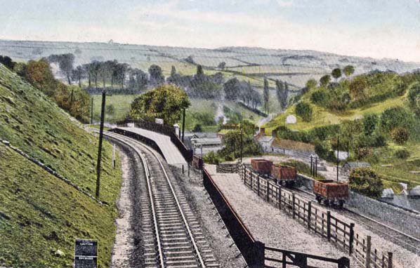
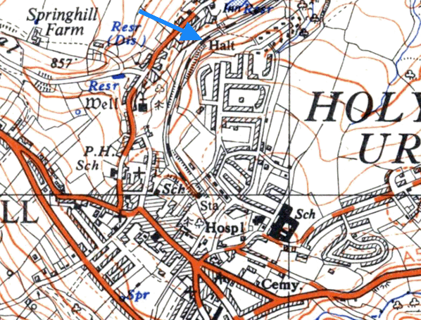
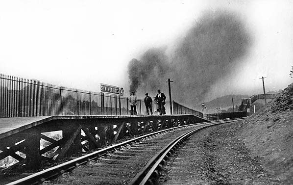
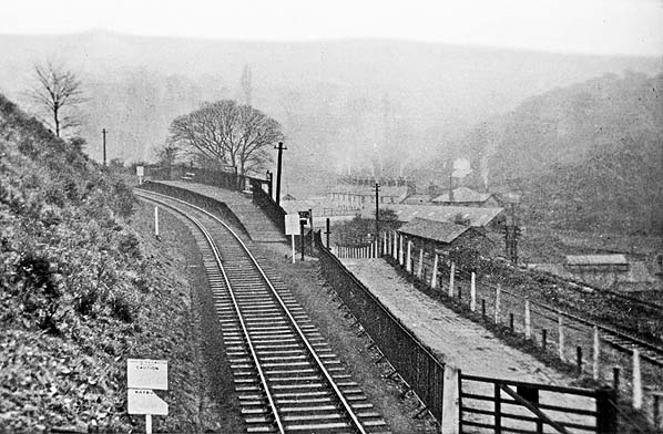
 The line was on the steep eastern slope of a valley at St Winefride’s. To the west of the line the ground sloped downwards and to the east it climbed. The halt consisted of a single wooden platform located on the west side of the single track. Access from the western side was via a sloping path which led up from Greenfield Street. The path connected to the platform at its northern end and then continued to run northwards parallel to the railway for approximately 50yd where there was a footbridge. The footbridge provided access to the eastern side of the line where a path connected to Strand Walk. The line was on the steep eastern slope of a valley at St Winefride’s. To the west of the line the ground sloped downwards and to the east it climbed. The halt consisted of a single wooden platform located on the west side of the single track. Access from the western side was via a sloping path which led up from Greenfield Street. The path connected to the platform at its northern end and then continued to run northwards parallel to the railway for approximately 50yd where there was a footbridge. The footbridge provided access to the eastern side of the line where a path connected to Strand Walk.
The platform had no shelter. It was provided only with a running-in nameboard and gas lighting.
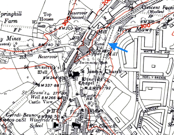
On the western side of the line running almost up to the site of the halt but at a lower elevation there was a siding. It followed roughly the course of the old HR and served the local industries. It connected to the main line at a point beyond the footbridge.
Only one train was allowed onto the branch at any time so no signals were required at Holywell Town. All of the points at the station were hand worked.
Passenger trains operated as a shuttle between Holywell Town and Holywell Junction. A powerful LNWR 0-6-2 tank engine was employed on the branch. It was coupled to two coaches and positioned at the Holywell Junction end of the train. This meant that it pushed the coaches up the steeply gradient to Holywell Town and on the return journey it could hold them in check when going downhill.
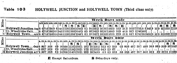
 The service proved popular and by July 1922 there were eighteen trains in each direction Monday-to-Friday. On Saturdays there was one less train in the up (Holywell Junction) direction. There was no service on Sundays and none was ever introduced. The service proved popular and by July 1922 there were eighteen trains in each direction Monday-to-Friday. On Saturdays there was one less train in the up (Holywell Junction) direction. There was no service on Sundays and none was ever introduced.
On 1 January 1923 St Winefride’s became part of the London Midland & Scottish Railway (LMS).
An intensive service of trains continued to run during the LMS years. During the summer months St Winefride’s was extremely busy with tourists who used it to visit the well.
The last timetable produced by the LMS in the summer of 1947 showed fifteen trains each way on Monday-to-Friday. On Saturday there were twenty trains in each direction but no services ran on Sunday.
On 1 January 1948 St Winefride’s Halt became part of British Railways [London Midland Region] (BR[LMR]). The summer timetable for 1948 (shown below) showed nine up and fouteen down trains Monday-to-Friday. On Saturdays there were eleven up and seventeen down trains.
In 1954 BR[LMR] published its intention to withdraw all services between Holywell Town and Holywell Junction.
The final summer’s timetable (starting on 14 June 1954) showed a minimal service to and from St Winefride’s Halt. The only down service to call was the train which left Holywell Junction at 7.40am, serving St Winefride’s at 7.45; the return working called at St Winefride’s at 7.52am, and there were no further up calls in the day. Passengers using the train to get to work had to make other arrangements for returning home. Visitors to the holy well clearly were no longer expected to use the halt.
The last passenger trains ran on Saturday 4 September 1954. The halt was closed completely on 6 September 1954 and it was demolished. The siding at St Winefride’s, which was by this time serving a cement works, remained in use until 11 August 1957.
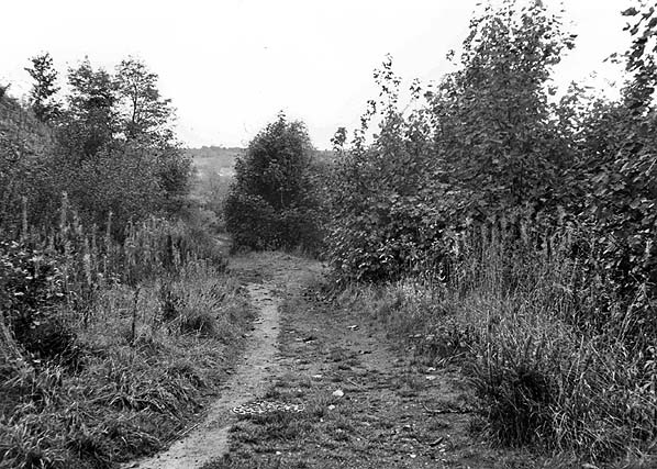
The halt site was later developed into a parkland area and the branch became a footpath.
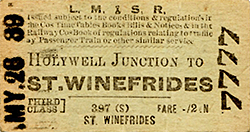
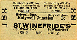
Tickets from Michael Stewart. Timetable from and route map by Alan Young
Sources:
- A Regional History of the Railways of Great Britain - Volume 11 - North & Mid Wales, Peter E Baughan, David & Charles 1980.
- Chester to Holyhead - The Branch Lines, Bill Rear, Oxford Publishing Company 2003.
See also: Holywell Town and Holywell Junction |

.jpg)

 Home Page