|
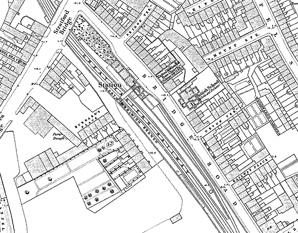
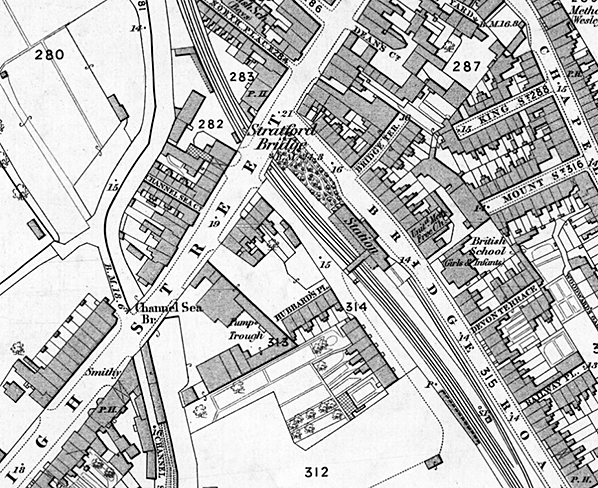
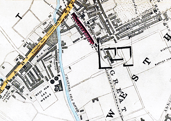
 Notes: Stratford Bridge station opened with the North Woolwich line on 14 June 1847. The station was provided with two facing platforms. The station building was on the down (east) side with a forecourt and entrance on Bridge Road. A short canopy was provided over the entrance, and on the platform side there was a canopy stretching the full length of the building. A footbridge from within the building gave access to the up platform, but the Ordnance Survey map for 1869 (reproduced below) shows no building opposite the booking office although a long building is shown near the south end of the platform. GER records show two waiting rooms were provided on the up platform in May 1881. A siding ran behind the south end of the down platform up to the station building. Notes: Stratford Bridge station opened with the North Woolwich line on 14 June 1847. The station was provided with two facing platforms. The station building was on the down (east) side with a forecourt and entrance on Bridge Road. A short canopy was provided over the entrance, and on the platform side there was a canopy stretching the full length of the building. A footbridge from within the building gave access to the up platform, but the Ordnance Survey map for 1869 (reproduced below) shows no building opposite the booking office although a long building is shown near the south end of the platform. GER records show two waiting rooms were provided on the up platform in May 1881. A siding ran behind the south end of the down platform up to the station building.
A public house called the Railway Tavern was opened opposite the station forecourt adjacent to the United Methodist Free Church (later a cinema).
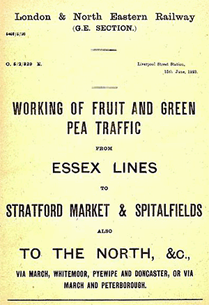
In 1879 the Great Eastern Railway established a fruit and vegetable market adjacent to the line on the up side just south of the station. The market hall was about 650ft in length with a broad arcade extending down the middle, on either side of which were the offices and warehouses of more than 50 tenant firms. Rail tracks ran through the market hall with two tracks on either side allowing wagons consigned to the various firms to be brought to the correct loading bays. From these wagons the commodities were carried direct to the warehouses or to the carts which drew up in the central road alongside the platforms. With a minimum of handling, the products were thus transferred from the farms in the country to the shops of the retailers in London and its neighbourhood. 12 sidings with accommodation for 400 - 500 wagons were provided on the west side of the market; these served the market and a new goods and coal depot.Initially five coal merchants operated from the market sidings; each of them had a wharf for stacking coal. When the market opened there were fewer sidings but in October 1885 the GER authorised the addition of a new road and sidings as goods traffic has increased in the previous six years from 11,217 tons to 33,409 tons. A private siding served the Patent Victoria Stone Works. In 1897 two sidings were laid alongside the Channelsea River which formed the west boundary of the site; these served the West Ham Gas Works which was on the west side of the river. Two aerial ropeways ran across the river to a terminal at the sidings. In June 1907 the market became the centre for the distribution of bananas in London with Fyffes and Elders both having depots on the site. A signal box was provided at the north end of the market on the down side of the main line.
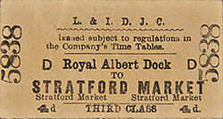
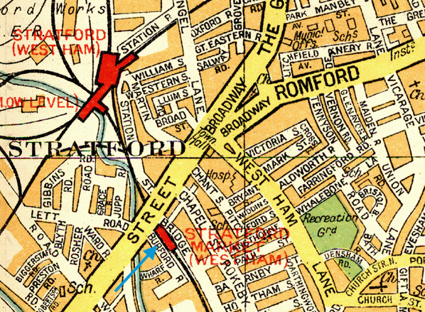
 Following the opening of the market, Stratford Bridge station was renamed Stratford Market on 1 November 1880. In 1892 the station was rebuilt to accommodate two additional lines on the up side for freight traffic. The contract for building the new station was awarded to A J Bateman of Ramsey, Hunts at a cost of £9322.4.10. Following the opening of the market, Stratford Bridge station was renamed Stratford Market on 1 November 1880. In 1892 the station was rebuilt to accommodate two additional lines on the up side for freight traffic. The contract for building the new station was awarded to A J Bateman of Ramsey, Hunts at a cost of £9322.4.10.
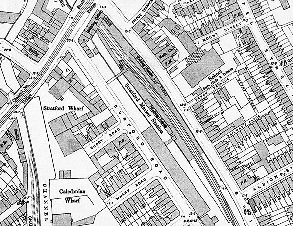
The platforms were rebuilt with a slight stagger, with the down platform butting up to the High Street bridge and the up platform finishing 50ft short of the bridge. The original entrance on Bridge Road was closed and the building was demolished. A new single-storey building with an attic was constructed on the bridge over the tracks on the High Street. It had moulded red-brick dressings, a hipped, tiled roof with finials and a pair of gabled brick dormers with moulded brick detailing framing a smaller central dormer. The entrance bay had a pair of circular-headed entrances with three tall windows to either side with moulded brick detail. The building just housed the booking office and stationmaster’s office with covered stairs to the down platform. Because of the distance between the building and the north end of the up platform a 50ft ramp was required to reach the steps down to the platform. There was additional access along a short path in Burford Road which led to a bridge over the goods lines and another flight of steps alongside the steps from the booking office. There was a range of seven small retail premises, one in the building and six alongside on the west side. These ran for a short distance along Burford Road and are contemporary with the building; they included coal merchants' offices. In the 1930s, two of the merchants with offices here were C W Tanner and Cornwalls. Access to Stratford Market and the goods and coal depot was 200yd along Burford Road.
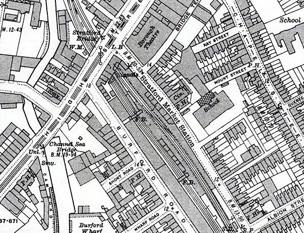
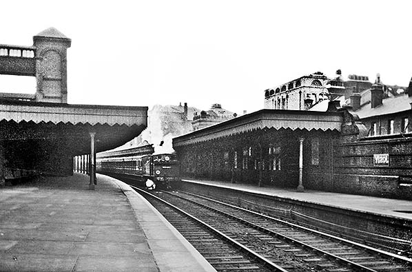
Each platform was provided with a brick building with a pitched tiled roof, tall chimneys and Dutch gables. These were offset from each other, that on the down platform being further north. Each building had six rooms and included waiting rooms and toilets. At the south end of the down platform building a flight of steps led up to an entrance in Bridge Road. Both platforms had a long canopy with a deep, lightly fretted valance supported on cast iron columns and steel girders. The new station came into use before the goods lines had been laid. The 1894 OS Town Plan (reproduced below) shows that provision had been made for a second pair of lines but these had not yet been laid.
 The GER built a 4-storey print works in Burford Road in 1893, and much of their printing requirements including posters, timetables and tickets was handled there. On the up platform there was a tower with steps up to a high-level walkway over the goods lines providing direct access between the works and the station. The works continued in LNER hands after the 1923 Grouping, with 61 million tickets being printed in 1932 when a report was prepared for the LNER Board on whether to concentrate all ticket printing at Stratford. The works were declared redundant after the railways were nationalised in 1948 and closed three years later. In recent years the building has found a new lease of life, and now provides workshop and office space for a number of small firms and businesses. The GER built a 4-storey print works in Burford Road in 1893, and much of their printing requirements including posters, timetables and tickets was handled there. On the up platform there was a tower with steps up to a high-level walkway over the goods lines providing direct access between the works and the station. The works continued in LNER hands after the 1923 Grouping, with 61 million tickets being printed in 1932 when a report was prepared for the LNER Board on whether to concentrate all ticket printing at Stratford. The works were declared redundant after the railways were nationalised in 1948 and closed three years later. In recent years the building has found a new lease of life, and now provides workshop and office space for a number of small firms and businesses.
On 5 April 1905 two trains collided just north of Stratford Market station. At this time, there were several junctions between Stratford Low Level platforms and Stratford Market station and the 8.31 pm down goods train from London Docks to Victoria Docks, consisting of an engine, 14 wagons and a brake van was making a move from the Western Curve to the Goods Lines. An empty coaching stock train was stopped at Stratford Market station awaiting a path towards Stratford Low Level when the driver, thinking he had the right to proceed, started the train, having failed to properly check the signals which were set against him. The two trains collided on the junction directly north of the station. The speed of the empty carriage train at the time of the collision could not have been great, as it had only just started from the station, but the speed of the goods train was probably about 12 miles an hour, and the damage done was considerable with the engine overturning and crushing its fireman, William Secker.
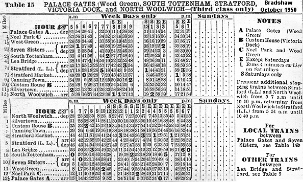
 The 1912 trade directory lists H J Hotson, stationmaster at Stratford Market. The station was renamed Stratford Market (West Ham) in 1898, reverting to Stratford Market in 1923. Initially the station was well used as trains running into Fenchurch Street via the spur line from the North Woolwich did not call at Stratford Low Level. During the 1930s the following services called at Stratford Market: Palace Gates – North Woolwich, Victoria Park – North Woolwich, Stratford Low Level – North Woolwich, Chingford – North Woolwich, Fenchurch Street – North Woolwich and Stratford - Beckton. Stratford Market signal box was abolished in 1933 and probably quickly demolished. The box was known as Stratford Market Southern Junction. The 1912 trade directory lists H J Hotson, stationmaster at Stratford Market. The station was renamed Stratford Market (West Ham) in 1898, reverting to Stratford Market in 1923. Initially the station was well used as trains running into Fenchurch Street via the spur line from the North Woolwich did not call at Stratford Low Level. During the 1930s the following services called at Stratford Market: Palace Gates – North Woolwich, Victoria Park – North Woolwich, Stratford Low Level – North Woolwich, Chingford – North Woolwich, Fenchurch Street – North Woolwich and Stratford - Beckton. Stratford Market signal box was abolished in 1933 and probably quickly demolished. The box was known as Stratford Market Southern Junction.
It is likely that the lighting at Stratford Market station was changed from gas to electric in 1938 but this has not been confirmed. When the Fenchurch Street service was withdrawn as a war time measure in 1940 passenger numbers dropped. The glass and timber was removed from the platform canopies during WW2 as a safety measure. There were no direct hits on the station although one high explosive bomb fell close to Bridge Road on 8 December 1940. This caused some damage to the Railway Tavern which remained closed until 27 November 1942.
After Nationalisation the station retained its LNER signage at platform level. This consisted of at least two large blue-and-white enamel running in boards on each platform, one at the north end and one in the middle. There was also an older LNER board with screw on letters at the south end of the up platform and there may also have been one at the south end of the down platform. The station was also fitted with LNER tablet signs - this was LNER policy when electric lighting was installed - but none of these can be seen in any of the 1950s pictures below. It is possible they were suspended from the canopy and removed when the canopy was dismantled during the war. The LNER blue-and-white signage was installed in 1938. The only BR sign appears to have been on the front of the booking office where there was a double-sided and illuminated sign: 'British Railways Stratford Market' and a double sided sign on a lamp post in Burford Road directing people to the Stratford Fruit and Vegetable Market.
The east coast floods of 31 January 1953 saw tracks in the station flooded and all services were suspended. At this time the station was served by 15 trains a day on the service between Palace Gates and North Woolwich. There was no Sunday service. The station closed from 6 May 1957 owing to limited traffic and the proximity of the larger Stratford station, which was also served by other lines.
A BR plan dated 5 December 1955 has survived showing details of proposed facilities for the handling of Continental Ferry Wagons at Stratford Market. Due to the technical differences between British and European wagons, Ferry Wagons were to a design which enabled operation either side of the Channel. A brief description of Ferry Wagons and their operation via the Zeebrugge - Harwich ferry can be read here. However and notwithstanding the plan of 1955, no further record of the Stratford Market scheme has been found so it is assumed to have never progressed beyond the planning stage.
Circa 1970 the station building was refurbished for office use and the building at 359 Stratford High Street was known as Coronet House; a number of different firms occupied rooms on both floors. By the early 1980s it just housed a minicab office for Coronet Mini Cars and by the end of the 1980s it was in use as a martial arts centre.
The Stratford Market sidings and the coal depot probably closed in the early 1980s. After that date the sidings found a new use for the temporary storage of redundant overhead line stock that had previously been stored at Romford. The goods lines through Stratford Market station were noted as being rusty and out of use in December 1983.
The degraded platforms lingered for many years after closure and were not finally removed until the early 1990s when the Jubilee Line was extended through the station on the site of the former goods lines. The extension from Green Park to Stratford was authorised in 1990 with construction beginning in December 1993. The station building was refurbished and the interior remodelled in 1995-96 by the Technical Services Department of the London Borough of Newham; this included a public walkway passing through the east corner using the original entrance. The extension opened in stages, with the first stage between Stratford and North Greenwich opening on 14 May 1999. During construction of the Jubilee Line extension a new storage and maintenance complex was built on the site of the former Stratford Market and adjacent coal depot. After 112 years at the Burford Road site, Stratford Market moved to the New Spitalfields development at Temple Mills, Leyton, on 13 May 1991. To commemorate the former use of the site the new facility was named Stratford Market depot. Construction of the depot started in 1994 and was completed by 1996 and the depot opened in 1998.
 The line through the station site to North Woolwich closed from 9 December 2006 for works to start on conversion to DLR operation. The government gave the go-ahead for the extension of the Docklands Light Railway from Canning Town to a new station at Stratford International in October 2006.The extension would meet the growing demand for public transport in the Lower Lea Valley area of east London, and also provide access to 2012 Olympic Games venues. For much of its length, the new line would utilise the North Woolwich line paralleling the Jubilee line. The only new section was the line to Stratford International which followed a former freight line. One of the seven stations (four reopened and three new stations) on the extension was to be at Stratford High Street on the site of the former Stratford Market station. The line through the station site to North Woolwich closed from 9 December 2006 for works to start on conversion to DLR operation. The government gave the go-ahead for the extension of the Docklands Light Railway from Canning Town to a new station at Stratford International in October 2006.The extension would meet the growing demand for public transport in the Lower Lea Valley area of east London, and also provide access to 2012 Olympic Games venues. For much of its length, the new line would utilise the North Woolwich line paralleling the Jubilee line. The only new section was the line to Stratford International which followed a former freight line. One of the seven stations (four reopened and three new stations) on the extension was to be at Stratford High Street on the site of the former Stratford Market station.
During construction further refurbishment of the former Stratford Market station building was undertaken. Internal alterations were required to relocate stairs, strengthen the suspended timber floors to the ground and to infill the first floor internal light well. Sections of the external brick spandrel panels were removed to provide additional pedestrian access from the High Street. A new steel stair was also constructed linking the concourse and platforms. The new station was provided with footbridge connections to Bridge Road and Burford Road in order to provide access to the surrounding areas. In order to locate the station here, part of Bridge Road has been permanently closed to vehicles except for emergency access, and access into Burford Road from the High Street has also been blocked. This avoided the need to take land from Rokeby School whilst also enabling the station to be located close to Stratford High Street. The new line was due to open in July 2010 but eventually opened on 31 August 2011. Off-peak, trains run every ten minutes to between Stratford International to the North and Woolwich Arsenal to the South. In the peak hours trains run every eight minutes between Stratford International and Woolwich Arsenal.
The station building is currently leased to the Britanico Cafe and Tearoom.

In June 2015 an LNER enamel plate from the departure indicator at North Woolwich was sold by auction. The guide price was £80-120 but it sold for £540.
 BRIEF HISTORY OF STRATFORD
- NORTH WOOLWICH BRIEF HISTORY OF STRATFORD
- NORTH WOOLWICH
In 1833 a railway line was proposed from Limehouse, to the north bank of the Thames opposite Woolwich. Nothing came of this scheme but in 1842, George
Parker Bidder put forward a proposal to link the Eastern Counties Railway at Stratford with the Thames to enable seaborne coal to be distributed throughout East Anglia.
Bidder's scheme was incorporated by Act of Parliament in 1844 as the Eastern Counties & Thames Junction Railway, with powers for a line from Stratford to a terminus on the Thames near the mouth of Bow Creek. It was opened between Stratford and Barking Road on 29 April, 1846 and was purchased by the ECR in August of that year.
Meanwhile, in 1845, an Act had been obtained for the North Woolwich Railway, which was to extend the Thames Junction line to a point on the river opposite Woolwich. Despite opposition from the Board of Trade the Bill was passed as the line would provide access to Woolwich and its arsenal which, at that date, was without a railway connection.
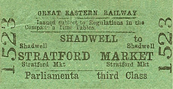
 After completion, the North Woolwich Railway was bought by the ECR in 1847 and the 21-mile line was opened on 14 June, 1847, together with a curve to the main line at Stratford, enabling through trains to be run between the Eastern Counties terminus at Shoreditch and North Woolwich. There were two intermediate stations at Stratford Bridge (later Stratford Market) and Barking Road (later Canning Town). After completion, the North Woolwich Railway was bought by the ECR in 1847 and the 21-mile line was opened on 14 June, 1847, together with a curve to the main line at Stratford, enabling through trains to be run between the Eastern Counties terminus at Shoreditch and North Woolwich. There were two intermediate stations at Stratford Bridge (later Stratford Market) and Barking Road (later Canning Town).
The branch quickly proved popular and an hourly service was established between Shoreditch and North Woolwich where two steam ferries, owned by the railway, provided the connection to Woolwich itself.
The line was extended northwards to a junction with the North London Railway at Victoria Park on 15 August 1854, to accommodate these trains; a new station was opened at Stratford Low Level. On 31 March 1858, the London Tilbury & Southend Railway opened a loop to the North Woolwich line at Abbey Mills providing a route into Fenchurch Street.
In 1849 the South Eastern Railway opened their line to Woolwich resulting in a huge loss in revenue to the North Woolwich line. In an attempt toregain revenue there was some development around the remote North Woolwich terminus. Silver & Company established a factory adjacent to the line and prospered to such an extent that the locality became known as Silvertown.
 In 1850 the Victoria Dock Company was authorised by Act of
Parliament to construct a dock east of Bow Creek and immediately
north of the railway. The entrance to the dock cut across the
railway and to avoid disruption to traffic the North Woolwich
branch was diverted around the north side of the dock, to rejoin
the original line about three-quarters of a mile west of the
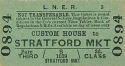
terminus. A station was opened on the new line at Custom House.
The original line was retained to provide railway connections
to the numerous factories which sprang up along the river bank
crossing the entrance to Victoria Dock by a swing bridge; it
was known as the Silvertown Tramway. In 1850 the Victoria Dock Company was authorised by Act of
Parliament to construct a dock east of Bow Creek and immediately
north of the railway. The entrance to the dock cut across the
railway and to avoid disruption to traffic the North Woolwich
branch was diverted around the north side of the dock, to rejoin
the original line about three-quarters of a mile west of the
terminus. A station was opened on the new line at Custom House.
The original line was retained to provide railway connections
to the numerous factories which sprang up along the river bank
crossing the entrance to Victoria Dock by a swing bridge; it
was known as the Silvertown Tramway.
Victoria Dock opened in 1855 and was an immediate success with its direct connection to the Great Eastern Railway. The district surrounding the railway quickly prospered with new stations opening at Tidal Basin and Silvertown. In 1862 the ECR merged with other lines to from the Great Eastern Railway.
In 1874 the Beckton gasworks company opened a single-line branch from Custom House to their works ,and in 1880 another branch was opened from Custom House to a terminus at Gallions close to the dock basin where the P&O liners berthed.
In 1864 the Victoria Dock passed to the London & St Katherine Dock Company which, in 1880, opened the Albert Dock as an easterly extension of the Victoria; it was joined to the latter by a short cut. It was again necessary to divert the North Woolwich line and an 1875 Act gave the dock company powers to divert the loop line through a tunnel under the cut between the two docks. The original line was retained as the high-level route owned by the dock company but in the event of the tunnel becoming impassable through any cause, the Great Eastern was given the right to use the original route free of charge until the tunnel was again fit for use. In 1872 the Great Eastern Railway opened a new line from Bethnal Green to Stoke Newington and Lower Edmonton with a branch from this line at Seven Sisters opening to Palace Gates in 1878. On 1 January 1880 a new spur was opened allowing a service to be established between Stratford and Palace Gates; this service later ran through to North Woolwich.
Both the Gallions and the Beckton branches were closed to passengers on 7 September 1940. Tidal Basin Station was closed to all traffic from 15 August 1943 after it was damaged by enemy action. Freight traffic to and from the docks was also, inevitably, affected by the war. In the early war years labour and equipment were transferred from London to other ports, but in 1944 preparations for D-Day put a heavy strain on the railways feeding the London docks.
 After the war passenger numbers were in decline with commuters finding the buses and trolleybuses more convenient; freight traffic was initially less affected but road haulage was beginning to make significant inroads. Passenger trains continued to run between Palace Gates and North Woolwich with short workings to and from Stratford Low Level. Stratford Market Station closed in 1957 and weekend services were withdrawn shortly afterwards. The service between North Woolwich and Palace Gates was withdrawn in 1963 and by the mid 1960s freight traffic had dwindled to almost nothing. One-by-one the local goods depots were closed with the final blow coming in the late 1960s with the rapid decline of their docks. After the war passenger numbers were in decline with commuters finding the buses and trolleybuses more convenient; freight traffic was initially less affected but road haulage was beginning to make significant inroads. Passenger trains continued to run between Palace Gates and North Woolwich with short workings to and from Stratford Low Level. Stratford Market Station closed in 1957 and weekend services were withdrawn shortly afterwards. The service between North Woolwich and Palace Gates was withdrawn in 1963 and by the mid 1960s freight traffic had dwindled to almost nothing. One-by-one the local goods depots were closed with the final blow coming in the late 1960s with the rapid decline of their docks.
The goods service was withdrawn from North Woolwich in 1970 and the passenger service was expected to follow with the line east of Custom House being reduced to single track. As a consequence of the uncertainty over the line’s future the surviving stations were allowed to deteriorate, and gas still lit Silvertown and Custom House stations until the mid 1970s. A reprieve came at the end of the 1970s when the GLC joined forces with British Rail to revitalize the North Woolwich line by extending the service from Stratford over the freight-only North London line to Dalston Junction.
 The line between Stratford and Dalston Junction had not seen a passenger service since 1943. New stations at Hackney Wick and Hackney Central were provided and all the stations between Stratford & North Woolwich were rebuilt. At North Woolwich this included the closure of the 1854 Grade II listed building. A new entrance building was provided on the south side of the line and the track re-laid into the southern platform to serve it. A new station was provided at West Ham for interchange with the District Line. The line between Stratford and Dalston Junction had not seen a passenger service since 1943. New stations at Hackney Wick and Hackney Central were provided and all the stations between Stratford & North Woolwich were rebuilt. At North Woolwich this included the closure of the 1854 Grade II listed building. A new entrance building was provided on the south side of the line and the track re-laid into the southern platform to serve it. A new station was provided at West Ham for interchange with the District Line.
The old station building and down (northern) platform were
acquired by the Passmore Edwards Trust and after renovation
the Old Station Museum was opened by the Queen Mother in November
1984. In May 1985 the line between North Woolwich and Dalston
was electrified with a new service introduced between North
Woolwich and Richmond with the resumption a full weekend service.
Despite this huge investment in the North Woolwich line its future was not secure. With the expansion of the Docklands Light Railway the line between Stratford Low Level and North Woolwich was closed on 9 December 2006. The section between Royal Victoria and Stratford was handed over to the DLR to be rebuilt as an extension to the DLR between Royal Victoria and Stratford International, which opened on 31 August 2011. The section between Custom House and North Woolwich was closed completely as both North Woolwich and Silvertown stations are within 300yd of existing DLR stations.
 Much of this section of the line has been handed over to Crossrail who will incorporate it into their route, and construction is well advanced in March 2016. In the meantime the Old Station Museum at North Woolwich closed in November 2008 and has been cleared of its exhibits and archive which have been dispersed to various other locations. The Grade II listed building is currently boarded up and awaiting a new use. Much of this section of the line has been handed over to Crossrail who will incorporate it into their route, and construction is well advanced in March 2016. In the meantime the Old Station Museum at North Woolwich closed in November 2008 and has been cleared of its exhibits and archive which have been dispersed to various other locations. The Grade II listed building is currently boarded up and awaiting a new use.
Tickets from Michael Stewart except 0229 Brian Halford.
Sources (Stratford Market):
Sources (North Woolwich branch):
To see the other stations on
the Stratford Low Level - North Woolwich line click on the station
name: Stratford
Low Level, West Ham,
Canning Town (1st), Canning
Town (2nd), Canning
Town (3rd), Tidal Basin, Custom
House, Silvertown
& North Woolwich
See also Gallions & Beckton branch lines |

 Home Page
market_old12.jpg)
 1916 1:2599 OS Map. The only apparent difference between this map and the 1895 map is the addition of the goods lines which have now been laid.
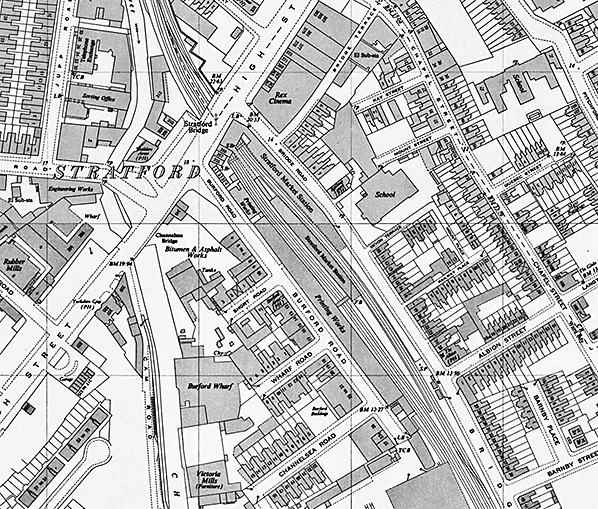
market_old5.jpg)
