
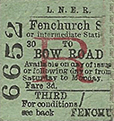
Station Name: BOW ROAD
Bow Road Station Gallery 1: Before 1907 - August 1942 old1.jpg) The bridge over Bow Road, part of the A11 which was once the Bank of England (later cut back to Aldgate) - Newmarket - Norwich trunk road, seen here sometime prior to July 1907 and looking towards Mile End Road. The station entrance, right, still stands in 2017 and the bridge, minus sign, is little changed. Part of the earlier street level building is seen on the far left; the entrance was on the far side of the bridge. This is a typical Edwardian street scene which displays a number of historically interesting features. The large sign on the bridge was once a common sight as railway companies promoted their own destinations and often connecting services of other companies. Such advertising became more relevant with the coming of electric trams. Of the destinations seen here, Greenwich will refer to the now-long-closed North Greenwich London & Blackwall station while Woodford and Loughton eventually became stations on London Transport's Central Line. Note that East London Line is preceded by 'for' and the line's name is shown in brackets. There would have been another of these signs on the other side of the bridge. Beneath the arch on the right a comprehensive display of posters can be seen while the vertical board to their right probably advertises places reachable by train from Bow Road, although the list, if that is what it is, appears more comprehensive than that on the bridge. Up on the viaduct a signal post carrying bi-directional arms - once a very common practice - can be seen. On the road, horse-drawn and hand-propelled transport predominates. Difficult to see among the ruts, potholes and horse muck are tram lines of the North Metropolitan Tramways’ horse-tram service; soon after this photograph was taken the route was electrified under the auspices of London County Council (LCC) Tramways. A sign of things to come was the motor omnibus (the full name 'omnibus' was still then in common use) seen heading east under the bridge. The omnibus has proved difficult to identify but under magnification it appears to be a Straker-Squire. The operator's identity is even more difficult to establish but a clue is the branding on the bodyside tumblehome. It is either Thomas Tilling or Union Jack and the styling suggests the latter. Union Jack was a branding used by the London Road Car Company, which was swallowed up by the London General Omnibus Company in 1908. The 'General' was the originator of the world-famous London red bus livery which was perpetuated by London Transport, of which the 'General' became a part upon its formation in 1933. Public transport along the Bow Road is described further with the 1915 image. Also of interest are the delightfully ornate street lamps. Not only is there a large lamp overhanging the road, there are also two smaller lamps on ornate brackets further down the standard. These lamps were probably the work of the City of London Electric Lighting Co Ltd, formed in 1891 and which had a generating station at Bow and also owned Bankside Power Station, Southwark. The lamps along Bow Road would, at this time, have been DC as were many early electricity supplies.
Copyright photo from John Alsop collection 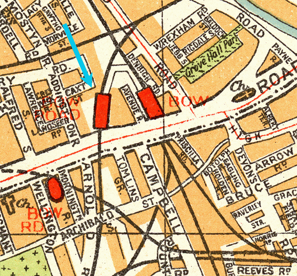 
Joseph Cross's Map of London 1850. The first station, Bow & Bromley is shown as is Victoria Park a&Bow, the interchange station with the Eastern Counties Railway. The North London Railway, which at this time was under construction is shown, but there is not yet a Bow station.
1870 1:2,500 OS Map. Bow & Bromley station is shown but is not named as a station because it had been closed for 20 years. Bow Road station would not open on the same site until 1875.
 Stanford’s Geological Library Map of London and its Suburbs 1878 shows the second station which opened in 1875. It is clear from this map that Bow Road station had a similar footprint to its predecessor Bow & Bromley.
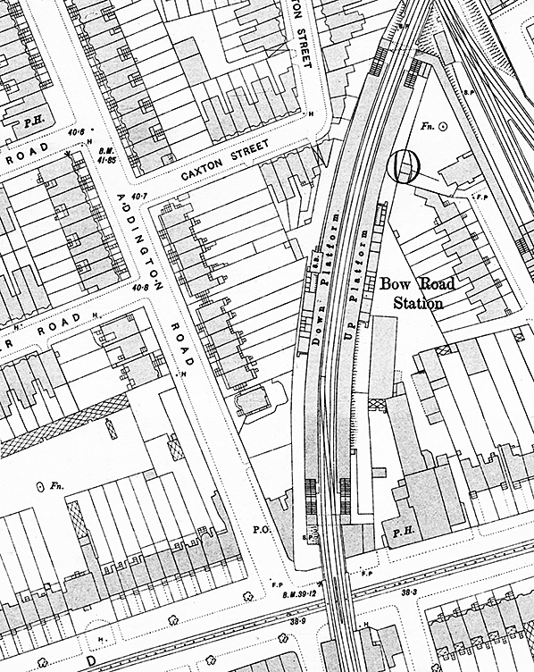
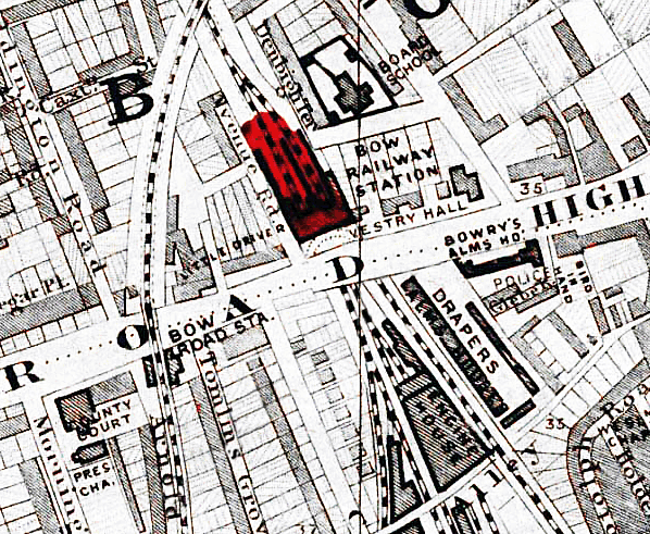
1895 1:1056 OS Town Plan clearly shows the layout of the third station at Bow Road. The street level booking office is on the east side of the bridge. From its rear, steps lead up to the up platform and through a subway to the down platform. The two platform buildings are slightly offset from each other with the signal box immediately north of the down platform building. The room layout of the platform buildings is clearly seen with the gents' toilet at the north end of both buildings. The sharp curve of the platforms is apparent. Shading indicates that the awnings covered the full length and width of the platforms. At the north end of the station further stairs lead down to a subway. The building to the right of the up platform stairs is the exchange booking office. A covered walkway leads to Bow station, part of which is seen on the far right. There is a crossover at the south end of the stations. The buildings from the previous station are seen on the south side of Bow Road. Click here for a larger version
1950 1:2,500 OS map shows Bow Road station in its final form. Although the map was published in 1950 the survey was made in 1948. The platform awnings have been shortened and now only protect the top of the stairs and the platform buildings. The hatching on the stairs indicates a glazed roof. The stairs at the north end of the station and the exchange booking office are shown as a ruin; the covered walkway is still shown. The previous station buildings have gone as have the signal box and crossover. A small building has appeared on the down platform to the north of the platform building.
Click here for a larger version. 
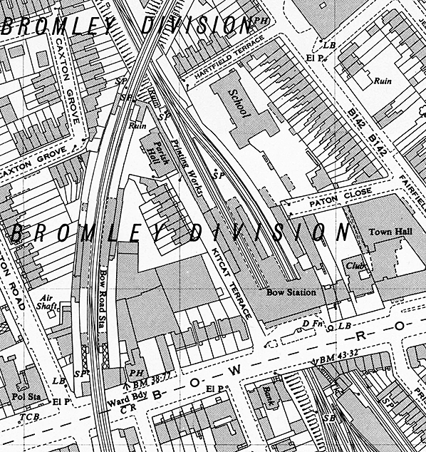
1950 1:2,500 OS Map shows the very cramped Bow Road goods yard sandwiched between the Bow Curve and the North London Line with the Southend running over it on a viaduct at its south end. The 1956 Railway Clearing House Handbook states that by that date it only handled general goods and still possessed a 5-ton capacity crane which is seen between the sidings to the left of the word 'coal'. The yard closed on 7 December 1964 and its site is now occupied by the Bow Triangle Business Centre.
Click here for a recent aerial view. old2.jpg) Looking through the bridge over Bow Road during, it is believed, 1915 and in the opposite direction to the 1907 view. The station entrance is out of view beyond the arch on the left. Unlike WWII when the greatest danger was the Luftwaffe's bombs, the only aerial threat in WWI was from occasional Zeppelin appearance. Scenes from WWI, such as this, are therefore difficult to recognise as wartime. There is, however, evidence in this view in the form of the poster partly obscured by the cart and its splendid shire horse on the left. It was a variation of the 'Your Country Needs You' theme and played upon the expression 'If that caps fits, wear it'. This particular poster reads "If the Cap Fits You" and was of course a rather clever part of the recruitment campaign for the army. The poster is based upon the Union Flag and was one of several variations of the same theme issued during 1915. By this date (see the 1907 view) the tramway had been electrified. Electric trams along the Bow Road served routes 61 (Aldgate - Bakers Arms) and 63 (Aldgate - Ilford), which continued as such under London Transport from 1933. Most of London's trams north of the river were withdrawn prior to WWII, the exceptions being routes 31, 33 and 35 via the Kingsway Subway, with many being replaced by trolleybuses. Upon conversion, the former Bow Road trams became trolleybus routes 661 (Aldgate - Leyton) and 663 (Aldgate - Ilford Broadway/Chadwell Heath). East London lost most of its trolleybuses from 1959, those along Bow Road going on 19 August that year. The bus replacements comprised seven routes, of which only the 26 (Aldgate - Leyton) bore any resemblance to a former trolleybus route. Beyond the bridge and on the right is a steam lorry, or steam wagon as they were known at the time. It is too far away for a positive identification but given the year it is most likely a Foden. Up on the bridge the large sign seen in the 1907 view has gone and been replaced by simpler advertising painted onto the girders. The emphasis is now not so much on the range of places served but more on the fares to the City and probably in an attempt to counter tram competition. Modern eyes may imagine a painter frequently changing the stated fares but there have been periods in our history when fares and prices in general remained static for many years, either to fight competition or simply because of a very stable economy. Beneath the bridge deck two trough-like devices can be seen. Probably of wood, their purpose was to prevent the tramway overhead wires from contacting the bridge as they rose slightly owing to the upward pressure of trolley booms. However, under examination of a larger view there appears to be section isolators beneath the bridge, in other words a short neutral section.
Photo from the John Mann collection old3.jpg)
Looking north from Bow Road bridge in August 1942. At this time the station was still as built with awnings stretching the full length and width of the platforms. The station was closed at this time, the only damage appearing to be the glazing on the stairs which was removed following damage in an air raid. The signal on the left is a Banner Repeater. They repeat the aspect of a signal further ahead where curves or structures obscure a driver’s view. The disc rotates so the horizontal bar mimics a signal arm. These signals are still used but today LED displays have replaced rotating discs.
Photo
from the John Mann collection
old4.jpg) Bow Road station looking south in August 1942. Although closed since 1917 the stairways that led to the interchange booking office and the covered walkway to Bow station appear to be in good order and still retain their glazing. Colour light signalling was installed on the Fenchurch Street in 1935 but an old semaphore signal is still seen on the right. This is the signal with which the Banner Repeater seen in the picture above worked in conjunction. The semaphore would have been linked mechanically to the Repeater, which may explain why it is still in use following the installation of colour lights. Bow Road station looking south in August 1942. Although closed since 1917 the stairways that led to the interchange booking office and the covered walkway to Bow station appear to be in good order and still retain their glazing. Colour light signalling was installed on the Fenchurch Street in 1935 but an old semaphore signal is still seen on the right. This is the signal with which the Banner Repeater seen in the picture above worked in conjunction. The semaphore would have been linked mechanically to the Repeater, which may explain why it is still in use following the installation of colour lights.Photo from the John Mann collection Click here for Bow Road Station Gallery 2: c1948 - 1970 [Source: Nick Catford]
 Home Page Home Page
|
 The original intention had been to build a junction with the ECR main line between Bishopsgate and Stratford stations and run through trains from Fenchurch Street but initially the ECR refused to sanction a physical junction, Victoria Park & Bow being a terminus of the LBER. The ECR was not particularly co-operative in stopping many of their services at Victoria Park & Bow, and in the March 1850 Bradshaw, the only ECR services to call at Victoria Park & Bow were the 6:07 am to Norwich on weekdays and the 1:37 pm to Norwich on Sunday. In the London-bound direction there were no weekday services at all, and just two services called on Sunday at 1:05 and 9:28 pm.
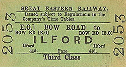 The new station was inspected by Col. Yolland RE for the Board of Trade on 29 September 1876. Col. Yolland was satisfied and Bow Road station opened to passenger traffic on 1 October 1876. No plans of the street level building have survived but it is believed that the booking office was in the arch beneath the line with an entrance on the west side of the bridge and steps up to each platform. There was a small coal office on the east side of the bridge. The two facing wooden platforms were 300ft in length and cantilevered off the viaduct. In December 1878 the GER agreed to extend the platforms across the bridge. This work was put out to tender on 8 April 1879 and awarded to M. Patrick & Sons at a cost of £644; the work was completed that year. There was a signal box with seven levers on the north side of the bridge on the up side.
 Since 1850 Fenchurch Street had been the London terminus for the North London Railway using the connection with the London & Blackwall south of Bow station. It soon became clear that the NLR needed its own city terminus and this was provided with a new route from Dalston to a terminus at Broad Street which opened on 1 November 1865. The service into Fenchurch Street was retained as a shuttle service from Bow. It was soon losing money and following the takeover of the NLR by the GER and the opening of the new Bow Road station there was little point in running the half-hourly shuttle which carried an average of 28 passengers. A decision was taken to withdraw the service which would be replaced by better interchange facilities between Bow Road and the former NLR station at Bow.
  The new station was more substantially built than its predecessor with a street-level booking office on the east side of the Bow Road bridge. The façade of the single-storey red-brick entrance building was in a classical style with a parapet (or blocking course) concealing the roof. There were three bays, each with a round-headed opening and keystone, and enclosed by pilasters. The central bay was stepped forward of its neighbours. The west and central bays each had a pediment, but it seems that none was provided over the east bay.
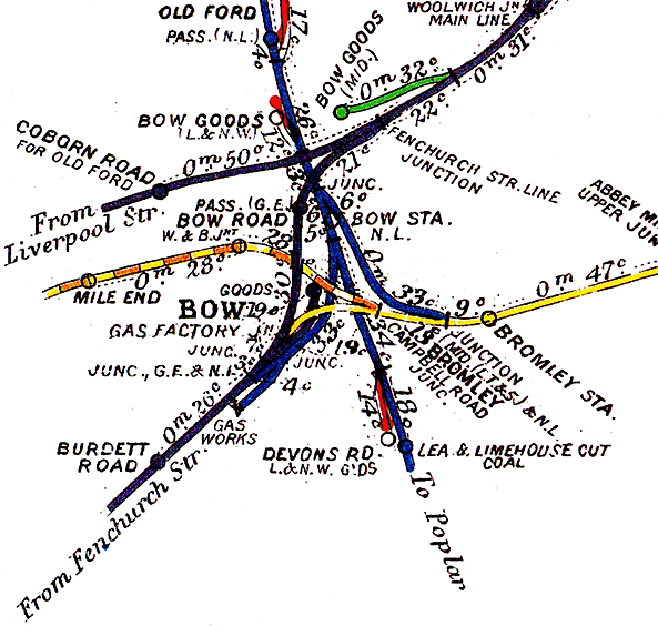
 After closure, the first station building was used as a coal office, later as an auctioneer’s premises, and then in 1912 was converted to a cinema until c1914; it then reverted to being a coal merchant's office, serving that purpose into the 1950s.
  Bow Road station came under the jurisdiction of the London & North Eastern Railway (LNER) after the 1923 grouping. Bow Road signal box was abolished on 3 March 1935 as part of a modernisation scheme for the Fenchurch Street line which included the installation of electric signalling.
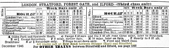
 Although Bow Road once again appeared in public timetables from 16 June 1947 the service to Fenchurch Street was shown as ‘suspended’ and the station did not reopen to passengers until 6 October 1947 with a much sparser service than pre-war. There were no up trains stopping there between 8.44 am and 4.14 pm and a similarly poor service for down trains. On Saturday there were no trains in the afternoon or evening.
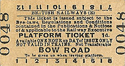 In 1990 the building was included in the ‘The Bow Heritage Trail’ and was provided with an oval blue plaque with the words ‘Bow Road Railway Station on the London & Blackwall Railway’, with an incorrect construction date of 1869. The trail does not have a good record for accurate dates. At Bow station, there is a similar plaque stating that the station opened in 1870 when it actually opened in 1850!