
Brasted Station Gallery 7: 1976 - January 2016
29.jpg)
A February 1977 view along Brasted's platform. The rather muddy mess on the right suggests that this view was taken around the time when preliminary work of the motorway had just begun. A felled tree can be seen lying on the trackbed in the distance.
Photo by David Jones from Flickr photostream 30.jpg) A further view from February 1977, this time looking north-east towards Dunton Green. The undergrowth which had previously engulfed the trackbed has been cleared. The station building had become effectively disused from September 1955 when it became an unstaffed halt, but it remained in a reasonable state of repair for a decade or so afterwards. This view shows how deterioration had set in following just over a decade of total disuse, with signs of settlement also being apparent. On the up side of the trackbed, the familiar telegraph poles still stand. Across the country, these poles can still be found hidden among the undergrowth alongside abandoned railways.
Photo by David Jones from Flickr photostream 26.jpg) This is looking north-east towards the remains of Brasted station in May 1977 during preliminary work for the construction of the M25. Station Road is a little way behind the camera.
Photo by J Woods from Alan Young collection 3.jpg) Spring 1977 and it is ‘all change’ at Brasted as preparations are underway ahead for the building of the M25; the station is seen from the platform side and looking towards Westerham. As indicated by the continued presence of the canopy, the platform still exists at this time and the preparations for the M25, foreground, have been built-up more or less to platform level. This would have been done to provide a wider and roughly level surface as in railway days there was a slight bank along the south
side of the track. Photo
by Nick Catford
4.jpg) Brasted looking towards Westerham in spring 1977, viewed from the contractor’s access road. Evidence of tracked vehicles, bulldozers etc., can be seen on the ground, as can evidence of off-road vehicle tyres. On the left, part of the platform and what appears to be the ramp can be seen and, at this point, still slightly above ground level. In the left background the two posts which might initially be assumed to be those that once supported the running-in board appear, under magnification, to be of some other origin; in any case, they look to be too far back to have been connected with the running-in board. The pole on the right may be the remains of the telegraph pole visible in several earlier images. It must have still been in use for one purpose or another when the photograph was taken, otherwise it would have been removed.
Photo by Nick Catford 5.jpg) A further spring 1977 view of Brasted, this time from further back and showing what was ongoing at the site rather better. The wider strip of land in the foreground is what would become the carriageways of the M25. Brasted village is a little way beyond the trees on the left. In the right background the site access, coming in from what had been the station approach road, can be seen; this is still in use as an emergency access point for the motorway. The stationmaster's house was several yards away behind the trees and far enough back to have been unaffected by the motorway works - noise and dust, no doubt, excepted.
Photo by Nick Catford 6.jpg) A further view of the station building from the approach road, also during the spring of 1977. A degree of caution is advised with these 1977 images. It is easy to assume that the building is in the process of being demolished, especially given the pile of debris ahead of the camera, but in all probability the building is simply falling apart on its own, perhaps aided by vibrations from contractor’s plant. Close examination of the remains of the roof around the nearest chimney shows what looks like evidence of fire damage. If so, the fire must have been small as the basic fabric of the largely wooden building is still intact. In any event, bulldozers ultimately removed all traces of the station the following year.
Photo by Nick Catford 2.jpg) A final view of the station in spring 1977. The coal merchant is still in business in the former goods yard. Note that the gate into the coal yard has been moved back to its original position at the east end of the station building. On the right is what looks like a road trailer of some description, perhaps in use as an office and mess by contractors.
Photo
by Nick Catford
21.jpg) An April 2007 view of Brasted station site seen from the top of the approach road with the M25 just visible far left. This is a similar viewpoint to the picture above. The station building stood where the young trees are directly ahead of the camera but a little to their left. The former goods yard is beyond the gate in the distance; although fenced and secure it is derelict and appears to have been out of use for many years.
Photo by Charles Bruce 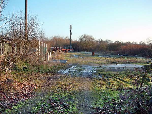
Looking north-east across the site of Brasted goods yard sometime in 2013. The station was to the left, but the wooden building visible on the left was probably not of railway origin and does not appear on any large scale maps. The mast in the background tells us the site is still used for communications but of an entirely different kind to trains. The remains of coal bins can be seen on the left in front of the phone mast. These are later bins; the original goods yard bins were roughly where the wooden hut is now seen. The small goods dock was on the right. The small goods dock was on the right.
35.jpg) The site of Brasted station looking east in April 2014 with the M25 on the left. The building would have been where the dense clump of trees stands, with the motorway hard shoulder occupying the former trackbed. The top of the station approach road would have been where the car stands on the right, the Ford Squire seen in the 28 October 1961 view of the station forecourt having long since disappeared.
Photo by Nick Catford 40.jpg)
Looking south-west through the site of Brasted goods yard in January 2016. The station was in the right background, beyond the hut. The M25 is behind the trees on the right. The timber posts on the right are the remains of a later set of coal bins built some years after the station closed. The original bins were where the wooden building is now seen. The building is something of a mystery. It is now in much worse condition than in the 2013 picture above and will probably soon collapse. It appears to be an old building but is likely to have been re-erected here at some time after closure of the railway. It does not appear on any large scale maps up to 1985 so might post-date the coal yard at this site. After the coal merchant left, the site was used to store vintage cars for some time.
Photo
by Nick Catford
Click on thumbnail to enlarge
 Home Page Home Page
|
28.jpg) Looking along Brasted's platform towards Dunton Green in 1976. Compare this with the similar, but monochrome, view from February 1977. One of the coal hoppers in the former goods yard is visible on the right. These belonged to the coal merchant and were nothing to do with the railway, having been installed after closure of the line.
Looking along Brasted's platform towards Dunton Green in 1976. Compare this with the similar, but monochrome, view from February 1977. One of the coal hoppers in the former goods yard is visible on the right. These belonged to the coal merchant and were nothing to do with the railway, having been installed after closure of the line.old_thumb10.jpg)
old_thumb34.jpg)
thumb22.jpg)
thumb32.jpg)
thumb42.jpg)
thumb41.jpg)
thumb36.jpg)
thumb37.jpg)
thumb38.jpg)
thumb39.jpg)
