
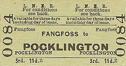
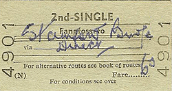
Station Name: FANGFOSS
|
| Date opened: | First in timetable May 1848 |
| Location: | Both sides of the road, east of the junction of Ling Lane with Newbridge Lane. |
| Company on opening: | York & North Midland Railway |
| Date closed to passengers: | 5.1.1959 |
| Date closed completely: | 7.6.1965 |
| Company on closing: | British Railways (North Eastern Region) |
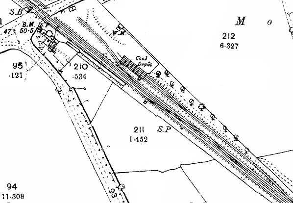
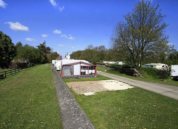
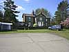
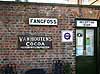
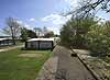
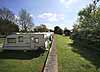
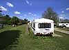
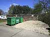
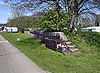
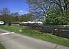
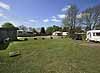
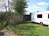
| Present state: | The site of the up platform and goods yard is now occupied by the Fangfoss Caravan Park. The owner lives in the station house, with an office and shop also in the station building. A number of enamel signs have been mounted on the wall, including an old Fangfoss station sign, although it is unclear if this is original. The platform remains in good condition It has been resurfaced in front of the station building and, for most of its length, is grass covered. Concrete has been laid along the platform edge covering the original edge stones. Opposite the platform the two-level stepped loading dock is extant together with some sections of brick wall from the coal drops. |
| County: | North Yorkshire |
| OS Grid Ref: | |
| Date of visit: | 4 May 2010 |
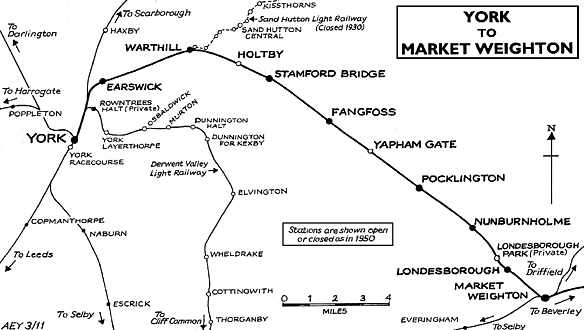
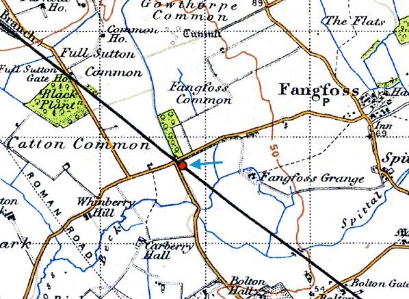
Notes: Although the York - Market Weighton line opened on 4th October 1847 it is unclear when Fangfoss station opened. It might have been on the same date as the line, although it did not appear in public timetables until May 1848. Fangfoss had staggered platforms: the down platform was on the north side of the level crossing while the up platform was on the south side. The main station building, which incorporated the stationmaster's house and booking office, was at the south end of the up platform adjacent to the level crossing and was a typical G T Andrews structure. It comprised a two-storey 'T' shaped brick house, with its long side parallel with the platform, and a central gable end facing on to the platform with a ground floor bay window overlooking the platform - a feature of most of GT Andrew's’ stations on this line. Timber waiting shelters, built to the standard NER design, were sited in the centre of both platforms. A signal box was sited at the up side of the line north of the level crossing, opposite the south end of the down platform. This controlled the crossing and access to the goods yard which was opposite the up platform. The goods yard initially (see 1893 map below) comprised two parallel sidings both serving coal drops which trailed into a long siding to form a shunting neck. There was also a general goods siding to the south, running diagonally across the yard and serving a two level loading dock with a weigh office and weighbridge nearby. At some point (see 1910 map below) the long siding became a loop, eliminating a slip across the running lines. The original track layout was later restored. There was a surge in passenger traffic during WW2 in connection with the bomber airfield at Full Sutton one mile north of the station. After WW2 passenger numbers dropped dramatically and, while the line remained open for passenger traffic, the station closed on 5th January 1959, but goods traffic was handled until 7th June 1965. It was not long, however, before the arrival of railways would ensure the rapid decline in waterborne transport in the area. The Leeds & Hull Railway Company was formed in 1824 with George Stephenson appointed as engineer. He proposed three inclined planes to be worked by three stationary engines for the hilly route out of Leeds, but the remainder of the line was very nearly level. This L&HR was one of a number of contemporary projects aimed at linking the east and west sides of northern England. The Leeds & Hull scheme soon stagnated, due in part to the stock market crash of 1825. In the meantime, the Knottingley & Goole Canal opened in 1826, turning Goole into a viable transhipment port for Europe. The growth of Goole as a port to rival Hull was sufficient to spur the Hull-based shareholders of the Leeds & Hull railway into action. At the end of 1828, they motioned that the railway should be built as far as Selby, with the remainder of the journey to Hull being made by steam packet, most importantly, bypassing Goole. The shareholders passed the proposal at a general meeting in Leeds on 20th March 1829, and the Leeds & Selby Railway Company was formed. The shortened line from Leeds to Selby was resurveyed by James Walker in 1829; he reported that the stationary engines were not required, with tunnels and cuttings being built in their place. Despite strong opposition from the Aire & Calder Navigation, who had a practical monopoly on transportation in the area, a Bill was passed by Parliament on 29th May 1830 allowing construction of the double-track line. By 22nd September, a single complete line of track had been built, and the railway was officially opened to passengers from a temporary terminus adjacent to the quayside at Selby. Both lines were complete by 15th December 1834, on which date the railway began to take goods traffic.
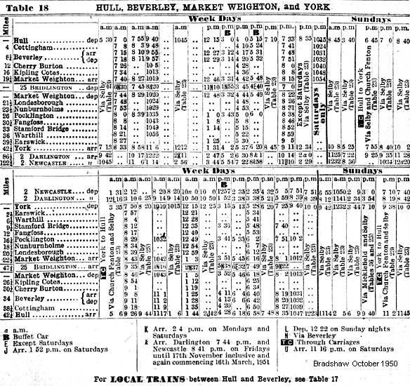
During this period of 'Railway Mania' there were proposals to build 107 miles of new railway in East Yorkshire, not all of which would come to fruition. One of these schemes was for a line between Selby and Driffield via Market Weighton, while another line from York to Beverley would also pass through Market Weighton. Although four lines into Market Weighton were eventually completed separately, George Hudson’s York & North Midland held powers for a complete route from York to Hull which was authorised by an Act of 18th June 1846, including a requirement that the line should be completed within five years. On the same date the Y&NMR. (East Riding Branches) No. II Railway Act authorised the building of a 22-mile single-track line from the Hull & Selby line to Market Weighton. Running across flat open ground with 22 level crossings, the line would have no major engineering features apart from a bridge over the River Derwent at Bubwith. The contractors for both lines were Messrs. Jackson and Bean with stations built by Burton & Son. Construction started on 12th August 1846, and the board expected completion on 30th September 1847 – they were out by only four days. It was hoped the Selby line would open two months later, but it was delayed, eventually opening on 1st August 1848. Initially three trains ran daily in each direction between York and Market Weighton, with two trains between Selby and Market Weighton. It was suggested that by juggling the timetable only one locomotive would be required to run both services - but this could not be achieved. By 1850 one of the Selby trains started at Pocklington on the York line, after a petition for better market travel facilities, which resulted in a general market ticket scheme from April 1851. The York line failed to live up to expectations. In August 1850 the directors heard that receipts at Huntington barely exceeded the stationmaster's wages, and there was a proposal to close the station. This did not happen, although there were some redundancies in an attempt to save money, and there was a proposal to single the line as early as 1853- while the doubling of the Selby line started in 1889.
The stations on the York line eventually suffered heavily from the North Eastern Railway policy of renaming, which avoided any possibilities of confusion, but resulted in many stations conveniently situated for a particular village receiving the name of one much further away. Huntington became Earswick, Stockton turned into Warthill, Burnby to Nunburnholme, and Shipton to Londesborough. From its opening Market Weighton had been a terminus, but it was always intended that the York line should be extended south to Beverley, and the Selby line east to Driffield. The extension to Beverley proved problematic due to the routing of the line across the Dalton Holme Estate. By this time the Y&NMR were in financial difficulties, and they argued that there was now little public demand for the line. This view angered local people and, when the Y&NMR became part of the North Eastern Railway in 1854, the company found itself under the local pressure to complete the line. There was much debate, which included a proposal to build a completely new line from Market Weighton to Brough. In 1860 the NER eventually agreed to build the line to Beverley as originally planned, and an Act was granted on 30th June 1862 with work starting in September that year. Progress was slow and, in 1864, the directors were trying to decide whether to provide an intermediate station at Goodmanham to the east of Market Weighton as well as Kipling Cotes (serving little more than a couple of farms) and Cherry Burton – Goodmanham was not built. The single-track extension opened on 1st May 1865, and a new revised timetable was immediately introduced with four stopping trains from York to Hull completing the journey in two hours. There was also a fast service that called only at principal stations. The NER began a programme of doubling the line in 1899 with a second platform being provided at the two intermediate stations. At this time the NER had no plans to extend eastward from Market Weighton to Driffield but, after several failed proposals, the Scarborough Bridlington & West Riding Junction Railway began building a line between Driffield and Market Weighton in 1888, having secured an agreement to work the line with the North Eastern Railway. The line opened to passenger traffic on 21st April 1890, having opened to goods traffic some weeks earlier. Following the 1923 general grouping, the LNER improved the service on both the York and Selby lines. In 1925 there were eight daily trains between York and Hull and seven in the opposite direction; not all trains called at all stations. There were two additional Saturday workings between York and Pocklington which were used to trial a new petrol rail car. One was in the morning and the other in the evening, but only the outward journey to Pocklington in the evening carried passengers. While the Market Weighton to York service still carried a reasonable number of local passengers, many of the stations on the Selby line were little used and had all closed by 20th September 1954. A limited passenger service between Selby, Market Weighton and Bridlington was retained, until final closure of the line to all passenger traffic was proposed for 15th June 1964. An appeal was rejected and the service was withdrawn on 14th June 1965. With the closure of Holme Moor and Everingham goods depots on 2nd August 1965, the whole route was completely defunct.
In May 1961 a contract for further modernisation work on the route was agreed with the engineering firm Westinghouse. Within weeks the first consignments of equipment were being delivered to Pocklington. The main part of the plan was to reduce costs further by singling the track but providing passing loops at Pocklington and Market Weighton. The line would be operated from a Centralised Traffic Control installation at Bootham Junction, York. Work was also to include the conversion of 19 of the line's 22 remaining gated level-crossings to automatic half-barriers and an overhaul of the signalling system, allowing the whole route to be controlled from fewer signal boxes.
Very little work had been carried out before the modernisation scheme was suddenly halted in February 1962, with British Railways announcing that the plans had been suspended for "re-assessment". What was happening became clear on 27th March 1963 when Dr. Richard Beeching released his report. The York to Beverley route was earmarked for closure, and was one of only three lines in the report to be presented as an economic case study. Beeching considered that closure was justified on the grounds that it was actually losing money when all the "terminal costs" were taken into account, and that closing the seemingly-profitable line would create greater savings that were more beneficial than the income it was making. He also argued that the majority of passengers were simply travelling between York and Hull, and that intermediate stations were underused. This made the line an unnecessary duplicate of the Hull to York Line (via Selby) despite the fact that the more direct line was far from underused. By 1964 all the goods yards had been closed, with the exception of Market Weighton and Pocklington where a small amount of traffic was still handled. The election of a Labour government in 1964 appeared to throw the route a lifeline, but Harold Wilson quickly backtracked on his electoral promises to halt rail closures. Protests from local authorities along the route and concerns of the official railways watchdog were ignored, and the Transport Secretary, Barbara Castle, approved the closure. The final trains ran on Saturday 27th November 1965, the very last being a six-car DMU running the 9:42 p.m. from York to Hull. Despite the snow, the train was packed with local people and enthusiasts eager to travel on the last train. Passenger services officially ceased as from 29th November 1965. The Minister's consent caused widespread bitterness. Critics of the closure claim that if the C.T.C. scheme had been revived it would have paid for itself in seven years and, thereafter, have permitted an annual profit of some £7,000. It also appeared that was an error over the alleged losses as, at the public inquiry, the British Railways Board stated these had been reduced by dieselisation and improved working to some £11,000. Yet the Ministry spoke of an annual deficit of some £100,000; a gentleman at Pocklington (who organised a protest) wondered, quite seriously, whether some secretary typed one naught too many. Four years after closure all the lands and assets of the mothballed route were sold off by British Rail, mostly to local landowners and developers, resulting in the construction of houses on parts of the route in built-up areas. Nonetheless the majority of the trackbed and several railway buildings survive to this day. Pocklington station (a Grade II listed building) has been preserved and is now the sports hall of Pocklington School. In Stamford Bridge the station house and engine shed survive in other uses as do the platforms on both sides of the old trackbed. The impressive brick and cast-iron viaduct at Stamford Bridge that carried the line across the River Derwent was spared from demolition in 1991 and subsequently repaired. Other railway and station buildings still survive in good condition at Warthill, Holtby, Fangfoss, Nunburnholme, Londesborough, Cherry Burton and Kipling Cotes. The 11-mile long Hudson Way footpath and cycleway follows the course of the line from Market Weighton – Beverley, with a car park at Kipling Cotes station.The substantial station buildings at Market Weighton were left abandoned before being pulled down in 1979, leaving no trace. Earswick was the only other station on the line to be totally demolished, although its position is marked by a railway signal outside the pub that now occupies the site. The continuation of the line from Beverley to Hull was spared from closure and today forms the southern end of the Yorkshire Coast Line between Hull and Scarborough. In recent years, there has been considerable public support among local residents for the reopening of the line between York and Beverley. There has even been campaigning to this effect, led largely by the Minsters' Rail Campaign pressure group who argue that the railway was unfairly closed and that East Yorkshire's roads, particularly the A1079, are struggling to cope with increasing traffic to and from Hull. A report by the Carl Bro Group for East Riding of Yorkshire Council in 2004 concluded that the project was feasible, but would cost around £239 million to build. The council subsequently gave their complete backing to the proposals, however no further developments have taken place.
Due to British Rail's selling off of the line's assets shortly after closure, parts of the trackbed in localities including Huntington, Stamford Bridge and Pocklington have now been irreversibly re-developed for housing. If the line is ever reconstructed it would be impossible for it to follow the original route for its whole length. However, documents published in 2006 as part of the East Riding of Yorkshire Council's Local Development Framework Transport Development Plan suggest that new routes into and around these existing built up areas have been identified and safeguarded alongside potential sites for new stations. Additionally section Section 6.63 of the Council's Core Strategy Document (published for public consultation in spring 2008) states: ‘...it is recommended that land for the following strategic infrastructure and transport schemes be protected from conflicting development: Railways - Beverley to York railway route; and Rail links to employment land at Melton, Hedon Haven and Carnaby. (if allocated).Sources:
Tickets from Michael Stewart, route map drawn by Alan Young, timetable alterations from Alan Young. Thanks to Sean of Selby (Flickr photostream) for providing transport on 4th May 2020 at short notice. To see other stations on the Earswick, Warthill, Holtby, Stamford Bridge,Yapham Gate, Pocklington, Nunburnholme, Londesborough Park, Londesborough, Market Weighton, Kipling Cotes, Cherry Burton |
|||||||
old1.jpg)
Fangfoss station looking south east c.1950s.
Photo from John Mann collection

1.jpg) Fangfoss station looking north west from the up platform in August 1971.
Fangfoss station looking north west from the up platform in August 1971.Photo by John Mann
2.jpg)
Photo by John Mann
6.jpg)
5.jpg)
Photo by Alan Lewis from his Flickr web site
4.jpg)
Photo by Brian Potter
Photo by Nick Catford
is seen on the right.
Photo by Nick Catford
thumb3.jpg)

 Home Page
| Last updated: Thursday, 18-May-2017 11:50:51 CEST |
© 1998-2011 Disused Stations
|