
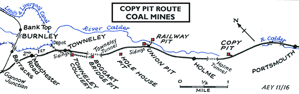
COPY PIT SUMMIT AND THE COLLIERIES FORMERLY SERVED BY THE COPY PIT ROUTE [Source: Alan Young]
The Copy Pit route, as it is still known today, acquired its name from the coal mine that operated adjacent to the railway close to its summit, known as Cliviger Copy Pit (or Colliery). There is no record of any platforms for miners to use or of trains making unadvertised calls for them to board or leave trains; such provision was common for lineside collieries in South Wales. The explanation lies in the relatively small number of miners who worked in the mine and the fact that most would have lived within walking distance. Sidings and a signal box were provided alongside the ‘main line’ and a short branch approached the mine. The first signal box at Copy Pit was of unknown design, construction and leverage, but in July 1878 a brick-built Saxby & Farmer Type 9 box replaced it, on the up side of the tracks and containing a 24-lever frame; the box was known as ‘Copy Pit Colliery’. This box was itself replaced in 1905/06 with a stone-based LYR Size 7 box with a 32-lever frame, located again on the up side but some distance east of its predecessor, and known as ‘Copy Pit’ (although ‘Copy Pit Siding’ in some documentation).
Nadin (1997 and 2008 - see Bibliography) note that coal mining in the Cliviger area has a long history, with small ‘bell pits’ being used to extract coal before drift (horizontal or near-horizontal excavation) and shaft mining began. Copy Pit originated in 1830 as a drift situated beside the Todmorden-Burnley Turnpike (now the A646, Burnley Road) a short distance south-east of Holme Chapel. It was owned by the Jobling family. The opening of the railway, adjacent to the road, stimulated the expansion of the mine; by this time the owners were known as the Cliviger Coal and Coke Co, and they installed sidings, screens and coke ovens to meet the rising demand for coal. Two shafts were sunk to a depth of 96yd (288ft) in 1860 to exploit a seam which yielded very good coking and steam coals. Most of the shafts’ length was bored through glacial sand and gravel. Davies (2010) notes that the colliery possessed an unusual winding system where the engine house was central, winding two single-cage shafts at once, each cage carrying four men. A Cornish beam engine was installed c1860 to pump the water-bearing strata. Furnace ventilation was employed at the pit, first at the base of the upcast shaft and later by a ‘cupola’ chimney shaft on the nearby hillside. The Arley seam was worked out in the 1930s and in 1937 two surface drifts opened up in its place. Coal cutting with pick-axes used the ‘pillar and stall’ method whereby large blocks of coal were left in place to support the roof. The coal was shovelled into 3½cwt tubs which were taken up the drift by endless-chain haulage, then over a gantry above Burnley Road to the colliery’s own sidings. At one time if local farmers were in need of coal they would take their carts to the sidings and back them under the hopper to collect it. Conveyor belts replaced the tubs in 1947, the year in which the colliery came under the ownership of the new National Coal Board; at this time 52 miners worked below ground with 17 on the surface. In 1945 Sam Jobling was manager of Copy Pit and Wilfred Collinge his under-manager. Mono-rails were installed to transport the coal in 1960.
Nadin (2008) includes an interview with Philip Entwistle, who worked at Copy Pit from 1951 until its closure in 1964. He lived at Rush Hey (on the Bacup road) from where he walked to the junction with Burnley Road then caught a bus to Copy Pit at a workmen’s return fare of 2d. He recalls that one of the destinations of local coal was the Sandringham Estate. This relatively small mine, employing 157 men and producing only 57,995 tons of saleable coal in its last full year, was closed in 1964 and by March 1964 all salvage work was completed. The last manager was John Malone. The colliery sidings and Down Loop (towards Holme Tunnel) had been recovered by 1969. Copy Pit signal box survived until 21 October 1973 when Preston Power Signal Box assumed control of the line. The derelict colliery site was landscaped by Lancashire County Council in 1981. The footbridge over the railway close to the sidings outlived the colliery, latterly carrying a pipe, took water from a moorland stream to the coal mine and to Copy Cottages (seen on the OS map extracts). Like the mine itself, the cottages and the pipe have now gone, but the stone abutments of the bridge survive in 2016.
Two other coal mines in the parish of Cliviger, operated by the same company that owned Copy Pit, were served by the railway. These were in the village of Walk Mill. One of them was Railway Pit – misleadingly named as it was the most distant of the three from the railway – and the other was Union Pit. Cliviger Railway Pit was sunk c1840 and worked for almost four miles towards the village of Hurstwood. Access was by means of two sloping drifts 450-500yd in length. The coal was moved from the mine to the sidings and coke ovens on the up side of the Copy Pit route by ginney wagons along a tramway. Davies (2010) states that candles were used for light in the pit, and two were needed per shift; watches were not required. Coal production ceased in 1938 but the arched entrance to Railway Pit Drift, the engine house and evidence of the ginney system remain to this day. Philip Entwistle (see above) recalled that the course of the tramway was filled in with rubble from the houses called Lower Damfield when they were demolished. These houses were originally stables but were converted to accommodate Cornish miners who came up when the local men were on strike.
Cliviger Union Pit (or Colliery) was sunk c1853 with a 150yd (450ft)-deep shaft. The Cliviger Coal Company’s headquarters were located here, and the colliery was accompanied by a gasometer that supplied gas to light the shaft bottom, the surface building and Lower Damfield miners’ cottages. Coal was moved via a tramway from the mine to the sidings that also served Railway Pit. Union Pit outlived Railway Pit by a few years, closing in 1943. A flight of stone steps which provided access to the shaft and the stone-lined arch of the surface drift near the railway are still in existence. Not connected to the railway, Cliviger Hole House Pit located just west of the bridge where the Copy Pit route crosses Burnley Road, the A646. Some coal was won from the pit but its principal role was as the pumping shaft for Union Pit. Hole House closed in 1939 and its buildings were demolished in 1964.
Towneley Colliery was located between a quarter and half a mile south-east of Towneley station, on the south-west side of the Copy Pit route. The main ‘Alice Pit’ began production in 1869 at a site adjoining the owner, Brooks and Pickup’s, existing fireclay works. In comparison with the Cliviger collieries Towneley was a larger undertaking. Sidings on both sides of the main line served the colliery. From the colliery a tramway over half a mile in length extended from to a coal depot on the Leeds & Liverpool Canal, requiring four tunnels (one of them passing beneath the Copy Pit route). The OS 1: 2,500 plan of 1912 shows a tramway (with two tunnels) extending south-east of the main site, to serve Boggart Bridge (or Boggart Brig) Pit which stood beside Todmorden Road (A671) just north of its junction with New Road (A646) and adjacent to the Copy Pit route which at this point is mid-way through the Towneley Tunnel. This mine was connected underground to Towneley Colliery. Mining began around the 1860s and continued until 6 March 1949, when both the Boggart and Towneley mines were closed by the new National Coal Board. The tramways between the mines at Boggart Bridge and Towneley, and between Towneley and the canal are also shown on the OS 1931 1:2,500 plan but they had been dismantled by 1959. Nadin (1997) reports an interesting incident related to Boggart when a farmer whose land lay above the colliery watched in amazement as one of his duck ponds suddenly drained, so that one minute the ducks were merrily swimming around, and the next they were walking on the muddy bottom of the pond. The colliery fireman had to rush to the coalfield to tell the miners to stop coaling immediately. At this point the workings were some 40ft beneath the surface and the farmer routinely heard the miners every time they fired a shot.
Today there is little evidence of the two mines at Towneley. The Kilns, a residential cul-de-sac, occupies the north-western area of Towneley Colliery’s site, and the rest is now steep, mossy hillocks and woodland. One of the hillocks has a tiny, traditional brick kiln built upon it in memory of the brickworks within Towneley Colliery. Adjacent to the Copy Pit route in its deep cutting, the course of the tramway can be followed beyond the north-west portal of Towneley Tunnel to the site of Boggart Bridge Pit, an area of uneven ground which has been planted with mixed woodland.
BIBLIOGRAPHY
Click here for more pictures
|
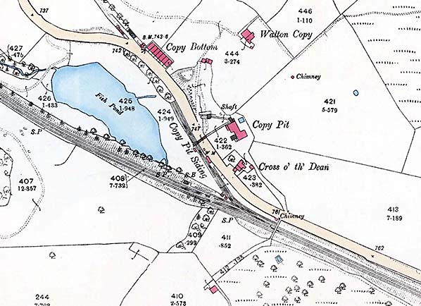 1895 OS 1: 2,500 map. Cliviger Copy Pit is a coal mine adjacent to the summit of the railway between Burnley and Hebden Bridge / Todmorden and it gave its name to the route. Sited north-east of Burnley Road, Cliviger, the coal was hauled in tubs from the mine to railway sidings (‘Copy Pit Siding’ on the map), crossing the road on a gantry. The only housing built nearby for the mine-workers was Copy Row, a terrace of seven cottages. The mine was active until the early 1960s. Click
 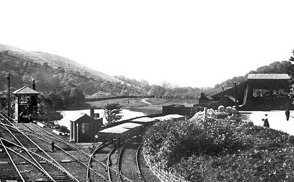 Looking north-west from the former footbridge close to Copy Pit summit c1900. The Saxby & Farmer Type 9 box dating from 1878 and containing a 24-lever frame is seen here; the box was known as ‘Copy Pit Colliery’. This box would be replaced in 1905/06 with a stone-based LYR Size 7 box with a 32-lever frame, located again on the up side but some distance east of its predecessor, and known as ‘Copy Pit’ (although ‘Copy Pit Siding’ in some documentation). The two tracks diverging sharply to the right serve the colliery. The Todmorden-Burnley road adjoins the railway to the right, and a small crowd has gathered on it
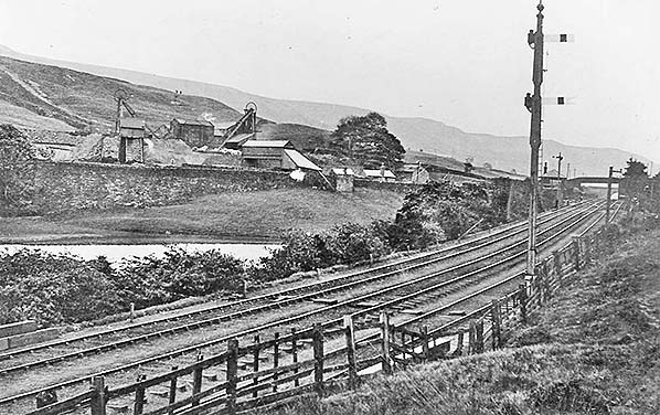 Looking south-east at c1900 towards ‘Copy Pit Colliery’ signal box and the summit of the railway. The coal mine to the left is Copy Colliery / Copy Pit and it is served by two tracks which join the railway just beyond the signal box. In 1905/06 this Saxby & Farmer box would be replaced with one of an LYR design located beyond the distant footbridge. Click
 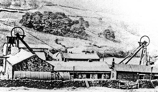 Photographs of Copy Colliery / Copy Pit seem to be scarce. This one, looking east, dates from 1948, soon after nationalisation of British coal mines.
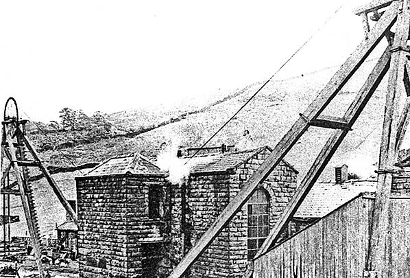 The back-to-back winders at Copy Pit (undated).
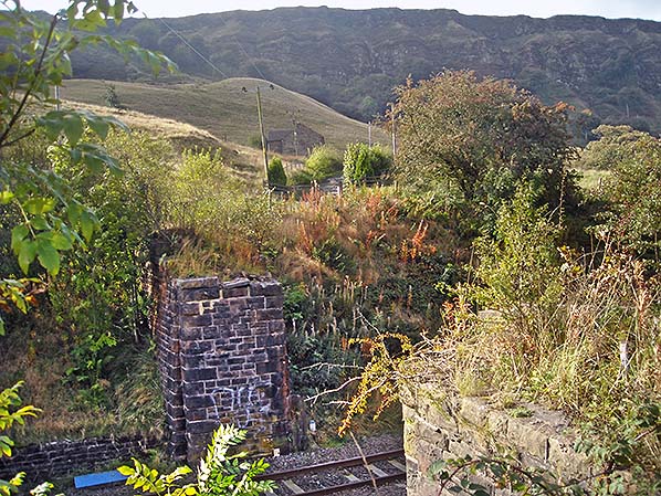 In October 2016 the abutments of a bridge survive immediately south-east of the point where the double-track siding led to Copy Colliery. The bridge originally carried a footpath but latterly a pipe was supported by the abutments. The precipitous edge of Cliviger Gorge can be seen in the distance.
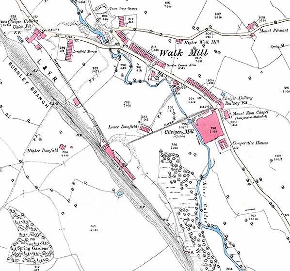 1893 OS 1: 2,500 map. Cliviger is a large parish in east Lancashire, and its name was used by the company that operated several coal mines. Two of the mines appear on this map at either end of the Cliviger village of Walk Mill which straggles along the Burnley-Todmorden road. The coals produced in Railway Pit and Union Pit are conveyed by tramways to the reception sidings with associated coke ovens on the up side of the railway between Towneley and Holme stations. Railway Pit would close in 1938 and Union Pit in 1943. Click
 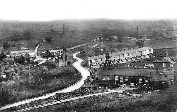 Cliviger Union Pit looking south-east from the embankment of the Copy Pit route between Towneley and Holme stations. Longfield Terrace is seen beyond the pit-head gear, and in the distance Cliviger cotton mill with its tall chimney and Railway Pit are seen to the right of the picture.
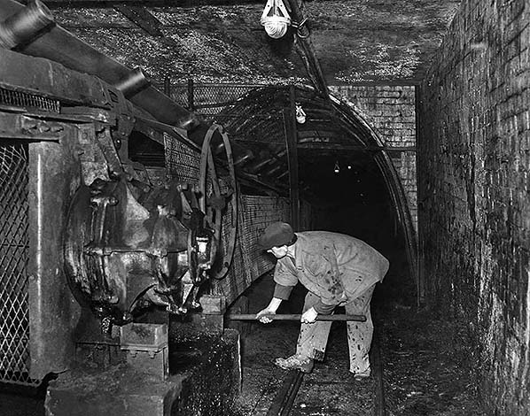 In December 1952 John Albanese is clearing the main conveyor belt in Cliviger Colliery.
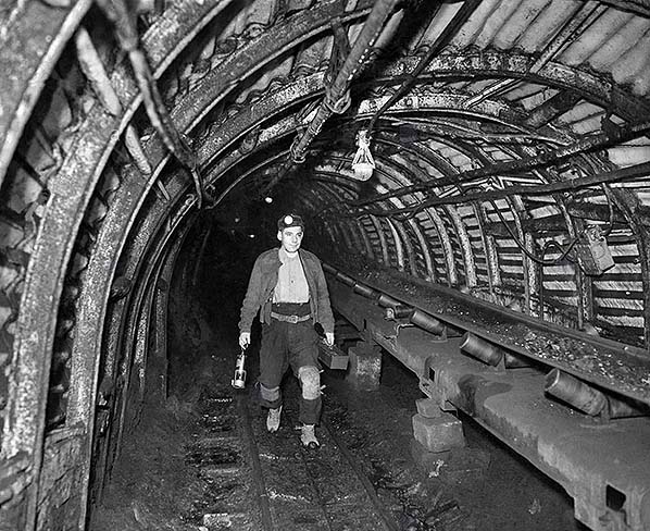 In December 1952 Albert Smith, a mine deputy, walks the mile to the coal face in Cliviger Colliery
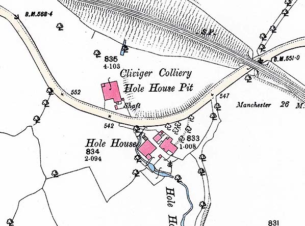 1893 OS 1: 2,500 map. Cliviger Hole House Pit is located just west of the bridge where the Copy Pit route crosses the A646 between Holme and Towneley stations. It was never connected by rail to the Copy Pit route despite being so close. Some coal was won from the pit but its principal role was as the pumping shaft for Union Pit. Hole House closed in 1939 and its buildings were demolished in 1964.
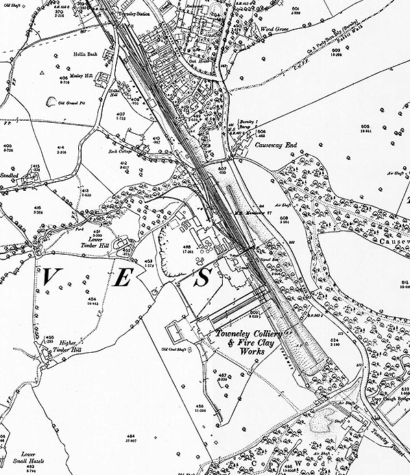 1893 OS 1: 2,500 map. Towneley Colliery and Boggart Bridge (or Boggart Brig) Pit were adjacent to the Copy Pit railway route between Holme and Towneley stations. ‘Towneley Colliery & Fire Clay Works’ is printed at the southern end of the mine’s surface buildings. Boggart Bridge Pit is not named but is close to the south-east corner of the map extract, next to Towneley Tunnel, with ‘Shaft’ and ‘Air Shaft’ labelled. A tramway is seen connecting the two mines, running parallel to the railway, and disappearing at the northern edge of the map on its way to a depot next to the Leeds & Liverpool Canal. Some mineral lines are shown within the site of Towneley Colliery and Towneley Colliery Sidings stretch from the mine as far as Towneley station, just north of the map’s border. Towneley Colliery Sidings signal box, which operated from 1878 to 1951 is shown as ‘Signal Box’. Both mines were to close in 1949. Click
 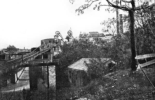 An undated photo of Towneley Colliery, probably in the early years of the twentieth century. The colliery closed in 1949.
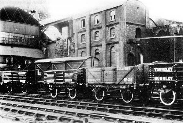 An undated view of the washery and screens at Towneley Colliery. The wagons bearing the colliery’s name will be noted; this was normal prior to nationalisation of most of Britain’s coal mines in 1947.
 It was not unusual for apparently separate coal mines to be connected to each other underground. This was the case for Burnley’s Bank Hall and Towneley Collieries, whose shafts were about a mile and a half apart.
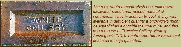

 Home Page