|
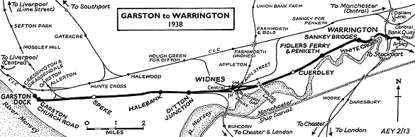
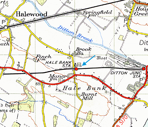
Notes: Halebank station was situated on the Garston and Warrington railway of the St Helens Canal & Railway Company (SHC&RC). The line opened in two stages from Runcorn Gap (Widnes) to Garston on 1 July 1852 and from Runcorn Gap to Warrington on 1 February 1853. Halebank station was opened as Halewood Road on 1 July 1852. It was located one mile north of Hale village and one mile to south-east of Halewood, on the east side of Burr Lane (later renamed Lower Road).
At the time of opening Halewood Road had two platforms and the main facilities were on the south side of the line.
On 1 May 1854 the SHC&RC made an end-on connection with the Warrington & Stockport Railway (W&S) at Warrington Arpley. This created a through route between Garston and the Manchester area.
In the mid-1850s Halewood Road was served by trains between St Helens and Garston Dock, and between Warrington and Garston Dock.
The dominant railway company in the area was the London & North Western Railway (LNWR) who owned the strategically important 1830 Liverpool and Manchester line and a main line route to London. The LNWR (and the earlier companies from which it was formed) had enjoyed good relations with the St Helens company from the opening of the later company’s first line in February 1833, and a great deal of traffic passed between the two systems. However the SHC&RC had always had ambitions to extend its system into Liverpool, which unsettled the LNWR as they would not welcome a rival route between Liverpool and Manchester.
 In the second half of the 1850s rival railway companies in the form of the Great Northern Railway (GNR) and the Manchester, Sheffield & Lincolnshire Railway (MS&LR) who wanted access to Liverpool saw an opportunity in the lines of the W&S and the SHC&RC. In February 1858 the GNR began to run a service between Garston Dock and London Kings Cross, but it is unlikely that it would have called at Halebank. This caused friction with the LNWR and also the promotion of two new lines. The first, promoted by the GNR & MS&LR, was for a line from Garston Dock to Liverpool Brunswick. The second, promoted by the LNWR, was from a line from a junction with the Garston and Warrington route just to the east of Garston (Speke Junction) to a junction with the Liverpool and Manchester line at Edge Hill, Liverpool. Both routes effectively created the through route to Liverpool that the SHC&RC had always wanted. To build the latter route the LNWR re-engaged with the SHC&RC and it was the first line to receive approval on 21 July 1859. The GNR & MS&LR took longer to get their approval as the Garston & Liverpool Railway (G&LR) which was authorised on 17 May 1861. In the second half of the 1850s rival railway companies in the form of the Great Northern Railway (GNR) and the Manchester, Sheffield & Lincolnshire Railway (MS&LR) who wanted access to Liverpool saw an opportunity in the lines of the W&S and the SHC&RC. In February 1858 the GNR began to run a service between Garston Dock and London Kings Cross, but it is unlikely that it would have called at Halebank. This caused friction with the LNWR and also the promotion of two new lines. The first, promoted by the GNR & MS&LR, was for a line from Garston Dock to Liverpool Brunswick. The second, promoted by the LNWR, was from a line from a junction with the Garston and Warrington route just to the east of Garston (Speke Junction) to a junction with the Liverpool and Manchester line at Edge Hill, Liverpool. Both routes effectively created the through route to Liverpool that the SHC&RC had always wanted. To build the latter route the LNWR re-engaged with the SHC&RC and it was the first line to receive approval on 21 July 1859. The GNR & MS&LR took longer to get their approval as the Garston & Liverpool Railway (G&LR) which was authorised on 17 May 1861.
These developments would have a big impact on Halewood Road station. On 1 July 1860 the LNWR took out a lease on the Garston and Warrington line and began to operate the trains along the route. The running powers for both the GNR and MS&LR that had been negotiated with the St Helens company were left in place as part of the parliamentary approval for the lease arrangement. The reason why the LNWR wanted control of the line was because it intended to create a shorter route to London via a bridge over the River Mersey at Runcorn Gap: it needed the section of Garston and Warrington line between Speke Junction and Ditton (a mile to the east of Halebank) to form part of the route. Authorisation for the line over the river was obtained in 1861, and work began in 1863.
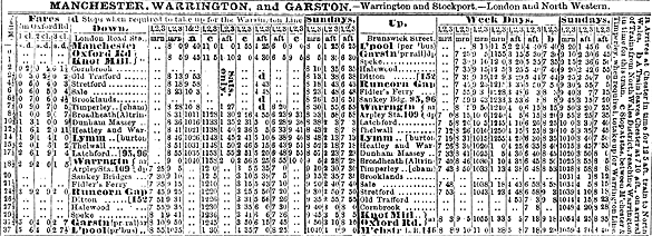
The February 1863 timetable seen below showed Halewood Road as having six trains in each direction Monday-to-Saturday and three each way on Sundays.
 |
On 15 February 1864 the line from Speke Junction to Edge Hill opened. From this date the LNWR trains that served Halewood Road station ran to and from Liverpool Lime Street. On 1 September 1864 the LNWR absorbed the SHC&RC.
The G&LR line between Garston Dock and Liverpool Brunswick opened on 1 May 1864 allowing GNR and MS&LR trains to run through to Liverpool. On 5 July 1865 the two companies formed a joint undertaking, the Cheshire Lines Committee (CLC), which was joined by a third partner - the Midland Railway - on 18 July 1866. The G&LR was absorbed into the CLC. The LNWR had been obstructive towards the GNR and MS&LR with regard to their services over the Garston and Warrington line. Because of this the CLC obtained an Act to build its own direct route between Liverpool and Manchester in the form of a line from a junction with the former G&LR near Garston (Cressington Junction) to a junction with existing lines in Manchester at Throstle Nest Junction. The new line which had opened completely by 2 September 1873 was only ¾-mile to the north of Halewood Road station. A station was opened on that line at Halewood, 1½ miles to the north-west of Halewood Road.
 The LNWR line over the River Mersey opened on 1 April 1869. From this date the section of line on which Halewood Road station was situated became part of the main line between Liverpool and London with direct links to Chester and North Wales. Services towards Warrington continued, but stopping trains running between Liverpool and Crewe and between Liverpool and Chester also served the station. The LNWR line over the River Mersey opened on 1 April 1869. From this date the section of line on which Halewood Road station was situated became part of the main line between Liverpool and London with direct links to Chester and North Wales. Services towards Warrington continued, but stopping trains running between Liverpool and Crewe and between Liverpool and Chester also served the station.
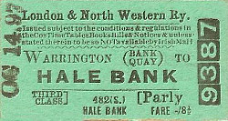
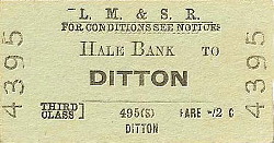
On 1 November 1874 Halewood Road station was renamed Halebank (for Hale) by the LNWR. This was presumably to avoid confusion with the CLC station at Halewood and to promote the fact that the LNWR station was closer to Hale than the CLC station was.
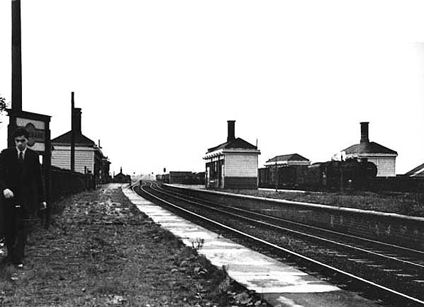
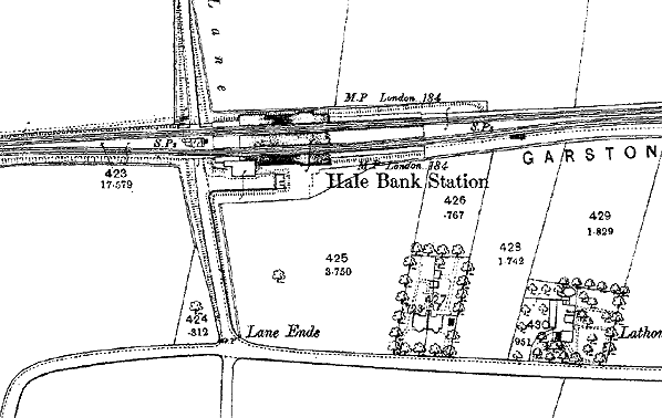
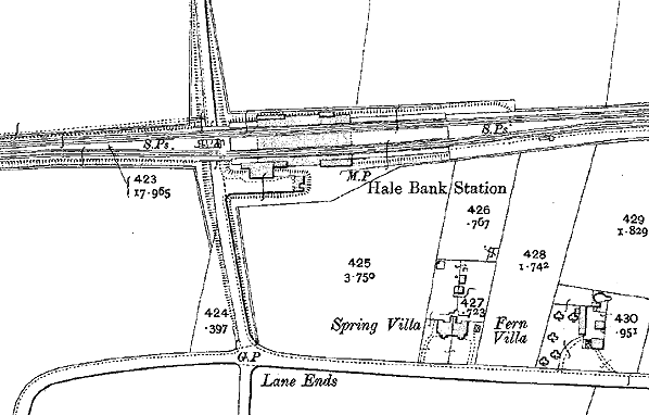
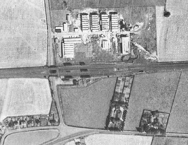
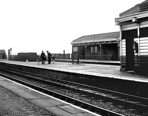
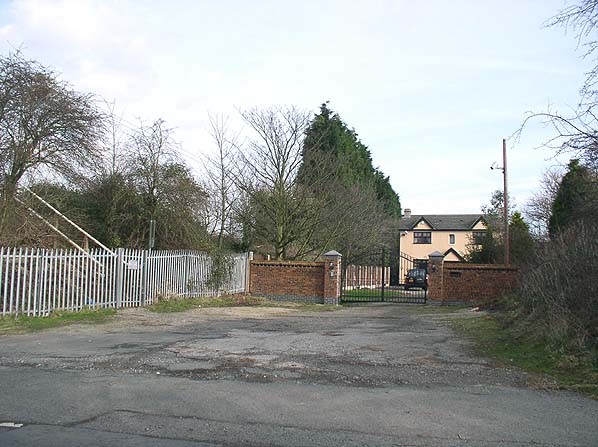
The route through Halebank became extremely busy and from 13 July 1891 it was quadrupled. The station was rebuilt for the quadrupling. In its post-1891 form it had four platform faces, two of which were part of an island platform. The main entrance to the station was via a single-storey street-level building located on the south side of the line. It was set back from Lower Road, being reached by a short driveway surfaced with stone setts. To the east of the driveway, at right angles to the line, was the stationmaster’s house. From the street level building a subway connected to the platforms. On each platform there were single-storey timber buildings with awnings that housed waiting facilities and toilets. The southernmost platform served the down slow line. The southern face of the island platform served the up slow and the northern face the down fast. The northernmost platform served the up fast line.
In May 1895 the suffix ‘for Hale’ ceased to be used. The December 1895 timetable showed Halebank being served by eleven up and twelve down trains Monday-to-Friday as shown in the table below. There was an extra up service on Saturdays and three trains in each direction on Sundays.
| Up Trains December 1895 |
Destination |
Down Trains December 1895 |
Destination |
| 6.56am |
Manchester London Road |
8.04am |
Liverpool Lime Street |
| 8.49am |
Warrington Arpley |
8.31am |
Liverpool Lime Street |
| 10.24am |
Acton Bridge |
8.54am |
Liverpool Lime Street |
| 12.57pm |
Manchester London Road |
10.24am |
Liverpool Lime Street |
| 2.01pm |
Warrington Bank Quay |
12.14pm |
Liverpool Lime Street |
| 3.11pm |
Manchester London Road |
1.37pm |
Liverpool Lime Street |
| 4.49pm |
Stockport |
2.28pm |
Liverpool Lime Street |
| 5.47pm |
Manchester London Road |
3.55pm |
Liverpool Lime Street |
| 6.34pm |
Manchester London Road |
5.34pm |
Liverpool Lime Street |
| 7.26pm |
Widnes |
7.24pm |
Liverpool Lime Street |
| 8.41pm |
Manchester London Road |
8.24pm |
Liverpool Lime Street |
| 11.38pm (Saturdays Only ) |
Widnes |
10.11pm |
Liverpool Lime Street |
Halebank station was closed as a wartime economy measure on 1 January 1917, and it did not reopen until 5 May 1919. The July 1922 timetable showed nine up and thirteen down trains served Halebank Monday-to-Friday. An extra up service ran on Saturdays and there were no trains on Sundays.
On 1 January 1923 Halebank became part of the London Midland & Scottish Railway (LMS). The summer 1932 timetable showed twelve up and fourteen down trains on Monday-to-Friday. On Saturdays there was an extra down trains and no trains on Sundays.
At Nationalisation on 1 January 1948 Halebank became part of British Railways London Midland Region. During the first summer of Nationalisation there were eight up and nine down trains from Halebank on Monday-to-Saturday.
Being in an isolated location Halebank was not well used and the winter 1956 timetable showed only eight trains in each direction Monday-to-Friday, with a couple of extra down trains on Saturdays, called there.
British Railways closed Halebank completely on 15 September 1958. It was demolished shortly after to facilitate the electrification of the line between Liverpool and Crewe. Only the station house survived as a private residence. In 2013 the line through Halebank was still a busy main line used by passenger and freight services.
The 8D Association - Dedicated to promoting the history of South Lancashire and North Cheshire railways. Web Site
Ticket from Michael Stewart, timetable from Alan Young and route map by Alan Young.
Sources:
- The St Helens Railway, Its Rivals and Successors – J M Tolston – The Oakwood Press 1982.
- Bradshaw Timetable December 1895.
- Bradshaw Timetable July 1922.
- LMS Timetable Summer 1932.
- BR (LMR) Timetable May - Sept 1948.
To see the other stations on the Garston and Warrington railway click on the station name: Garston Dock, Garston Church Road, Speke, Ditton, Ditton Mill, Widnes (1st), Widnes South, Cuerdley, Sankey Bridges,
Warrington Bank Quay Low Level and Warrington Arpley.
To see stations on the Warrington and Stockport railway click on the station name: Latchford, Thelwall, Lymm, Heatley & Warburton,
Dunham Massey & Broadheath.
|

.jpg)
.jpg)
.jpg)
.jpg)
 Home Page