|
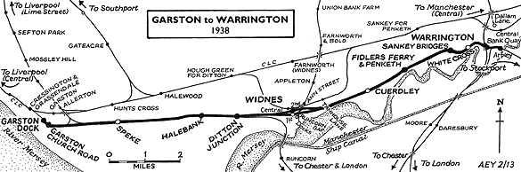
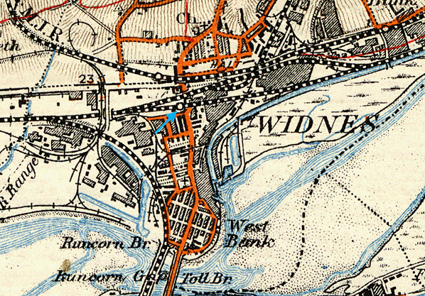
Notes: Widnes (1st) station opened as Runcorn Gap on 1 July 1852. The station was situated on the St Helens Canal & Railway Company’s (SHC&RC) Garston line which was authorised on 16 July 1846. The line ran from the company’s original 1833 route that linked St Helens with Runcorn Gap to Garston Dock. The original had at its southern end at Widnes Dock on the northern side of the River Mersey, just to the east of the Runcorn Gap (a narrow point in the river across which a ferry operated). Goods was transferred from rail to boat and ship at Widnes Dock but, due to its location in the upper reaches of the river, it was constrained by tides, and for 80 days per year could not be used. Garston was not as constrained by tides and could be reached by larger vessels. It was for this reason the SHC&RC built the line to Garston. Six miles to the east of the Widnes Dock lay the manufacturing town of Warrington. The SHC&RC obtained an Act on 22 July 1847 to build a line between Runcorn Gap and Warrington. It opened to a temporary terminus at Warrington White Cross on 1 February 1853, creating a Garston and Warrington railway.
 |
A passenger station had opened at Runcorn Gap in September 1833. It was located on the 1833 St Helens line to the north of the Widnes Dock on the north side of the Sankey Canal (which had merged with the original St Helens and Runcorn Gap Railway company on 21 July 1845 to form the SHC&RC). The Garston and Warrington line crossed the St Helens on the level at right angles, at what became Widnes Dock Junction. A connection from the St Helens line to the Garston line ran north to west, and it was this connection that provided the opportunity for the creation of a new Runcorn Gap station.
The new station was located on the west side of Waterloo Road, a throug fare that ran north/south and linked the ferry at Runcorn Gap with the wider South Lancashire area. Once rural, the area around the Widnes Dock had developed with industries since the St Helens & Runcorn Gap Railway had opened in 1833. However, at the time of opening, the new Runcorn Gap station was bordered only by fields and a woodland.
The Garston and Warrington line was double-track, and Runcorn Gap was provided with two platforms. No photographs survive of it so it is not known what facilities it had. To its east was a level crossing which carried Waterloo Road over the line; to the west were goods facilities.
Once the line to Warrington had opened (from 1 May 1854 it was extended to Warrington Arpley where it made an end on connection with the Warrington & Stockport Railway creating a through route to the Manchester area) Runcorn Gap station was served by passenger trains that ran to Garston Dock, St Helens and to Warrington. Most trains ran between Runcorn Gap and St Helens. Arrivals from St Helens ran on alternately to Garston or Warrington, the Warrington trains having to reverse at Runcorn Gap station; the same applied in the other direction. Runcorn Gap station became a busy place, and Inns, shops and housing developed along Waterloo Road to serve it. Industry also continued to grow, and brought about the expansion of railway facilities.
 |
In the late 1850s the SHC&RC became embroiled in the railway politics of the era. The dominant player in the area was the London & North Western Railway (LNWR) with which the smaller company had enjoyed good relations. However having a line that was part of a route between the Liverpool area and Manchester which could rival the LNWR’s own route, the Great Northern Railway (GNR) and the Manchester, Sheffield & Lincolnshire Railway (MS&LR) saw an opportunity to reach Liverpool. From June 1858 the GNR started to run a passenger service between Garston Dock and London Kings Cross. It is likely that this service would have called at Runcorn Gap, giving direct access to the capital city. The GNR and MS&LR also became involved in a scheme to extend the line from Garston into Liverpool. These developments alarmed the LNWR and caused friction between this company and the SHC&RC.
To counter the threat from the rival companies the LNWR took out a lease on the Warrington & Stockport Railway on 13 August 1859 (absorbing it fully on 1 January 1861). This led to discussions with the SH&RGR about the Garston and Warrington line. On 1 September 1860 the LNWR took out a lease on the line and began to operate train services along it. Runcorn Gap was served by LNWR trains running between Garston and Warrington and by SHC&RC trains running to and from St Helens; by the 1860s the former had become the more numerous. GNR services also continued to run, the company having received running rights as part of the Act that allowed the lease to proceed.
On 1 September 1864 the LNWR absorbed the SHC&RC. By this time a number of developments had taken place. The GNR and MS&LR had backed a scheme that had created the Garston & Liverpool Railway, which opened on 1 May 1864. On 5 July 1865 the two companies had formed the Cheshire Lines Committee (CLC) which took over the line. The CLC operated passenger trains between Liverpool Brunswick and the Manchester area via the Garston and Warrington line; these services called at Runcorn Gap station. The CLC trains were hauled by MS&LR engines as the CLC had none of its own. On 18 July 1866 the Midland Railway (MR) joined the CLC as a third partner.
The LNWR had not been idle during these developments. It had supported the SHC&RC to create a route between Garston and the LNWR Liverpool and Manchester line at Edge Hill in Liverpool. That line had opened on 15 February 1864, shortly before the LNWR took over the SHC&RC. A direct route from Runcorn Gap to Liverpool Lime Street was thereby created and, with the opening of the new line, LNWR services were diverted to run that way.
By 1864 the township of Widnes had developed on the north bank of the Mersey at Runcorn Gap. It had developed to such an extent that in 1865 a Widnes Local Board was created to administer the district (which became a full Borough in 1892). To reflect the growing status of the town the LNWR renamed Runcorn Gap station ‘Widnes’ when they took over the SHC&RC on 1 September 1864.
In 1861 the LNWR obtained an Act to build a line from Ditton (one mile west of Widnes station) to their main line to London at Dutton (at what became Weaver Junction) via a bridge over the Mersey at the Runcorn Gap. The purpose of the line was to create a more direct route between Liverpool and London. When the line opened to passenger services on 1 April 1869 the western end of the Garston and Warrington Railway became a significant main line. The route east of Ditton was relegated to the status of a secondary passenger route, but a main freight artery.
Widnes station continued to see main line services in the form of those operated by the CLC and its partners.
When the Act had been drawn up that allowed the LNWR to absorb the SHC&RC , it had placed a requirement upon the former to make an investment of £100,000 at Widnes to improve the facilities. One of the main issues at Widnes was the flat crossing at Widnes Dock Junction: it was a bottleneck and a serious impediment to traffic growth. The solution was to build a new 1 mile xx chain line, the Widnes Deviation, to the north of the Garston & Warrington railway. The line, which opened to freight services on 1 April 1869, branched from the original route 28 chains west of Widnes station at Widnes West Deviation Junction and climbed up and over Victoria Road. It then ran eastwards passing over the St Helens line before rejoining the original route at Carterhouse Junction. A connecting spur was put in from the St Helens line to the deviation.
A new Widnes station was created on the deviation line only 50 yards to the north of the existing facility, but on the east side of the road. It opened on 1 March 1870, and the original Widnes station was closed.
By 1870 the goods facilities at Widnes were quite extensive. To the west of the original station there was an extensive yard entered from Hutchinson Street. A large goods station with a goods shed had developed just west of the station, on the south side of the line. As space was at a premium the original Widnes station was quickly demolished, and sidings were laid were the platforms had been.
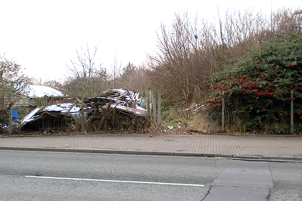
Although all passenger, and most through freight services, ran via the deviation, the original line through Widnes continued to be used by local freight services until 10 March 1969. The goods station closed on 31 March 1969 but the yard at Hutchinson Street remained in use until 1989.
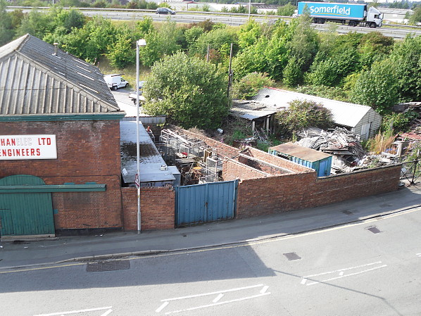
The site of the original Widnes station was obliterated by the construction of Watkinson Way in the mid 1990s.
The 8D Association - Dedicated to promoting the history of South Lancashire and North Cheshire railways. Web Site
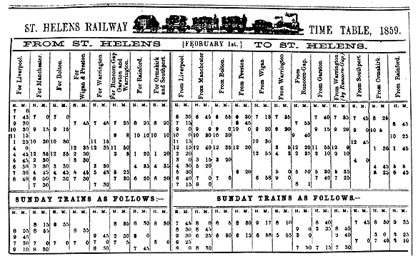
Timetable from Paul Wright and route map by Alan Young.
Sources:
- The St Helens Railway, Its Rivals and Successors – J M Tolston – The Oakwood Press 1982.
To see other stations on the Garston and Warrington Railway click on the station name: Garston Dock, Church Road, Speke, Halebank, Ditton, Ditton Mill,
Widnes South, Cuerdley, Fidlers Ferry & Penketh, Sankey Bridges,
Warrington Bank Quay Low Level and Warrington Arpley
See also Warrington & Stockport Railway stations: Latchford, Thelwall, Lymm, Dunham Massey and Broadheath.
See also: Runcorn Gap
See also features: Widnes Deviation Railway,
Widnes Goods (Hutchinson Street Yard) and Widnes Dock Junction |

old1.jpg)
.jpg)
 Home Page
 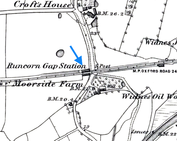 The first Widnes station as it was at the time of opening when it was called Runcorn Gap. The station was in a rural location. Over the next thirty years the surrounding area would change beyond recognition.
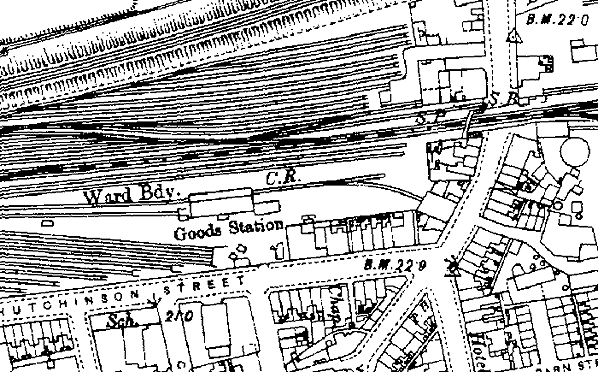
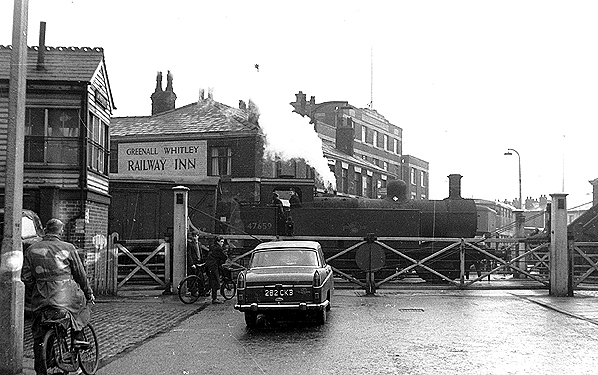
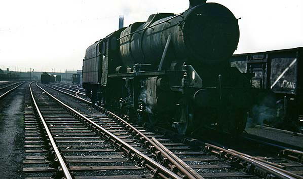
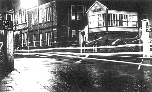 Waterloo Crossing. Widnes (1st) station was located on the west side of the crossing (to the left of the photographer) just out of view. On the other side of the crossing is Widnes No.6 signal box which closed in March 1969.