Notes: Runcorn Gap station was the original southern passenger terminus of the
St. Helens and Runcorn Gap Railway (SH&RGR) which ran from St. Helens
in the north to the banks of the Mersey at Widnes in the South,
originally with no intermediate stations. During the 18th Century St Helens had developed as a coal mining and manufacturing area but it suffered from having no navigable river and so all goods had to go by road which was slow and difficult. In 1757 the Sankey Brook Navigation Canal was opened between St Helens and Sankey Bridges on the River Mersey. The canal improved things for the industries of St Helens and the town flourished.
 By the 1820s though the levels of traffic between St Helens and the River Mersey were such that they taxed the canal to its limit. Also during periods of extreme cold or drought the canal could not be used. In 1829, as construction of the Liverpool and Manchester Railway was underway a group of industrialists arranged for a survey to be carried out between St Helens and Runcorn Gap with a view to building a railway and a dock. The survey was carried out by Charles Blackner Vignoles who had also undertaken survey work on the Liverpool and Manchester. By the 1820s though the levels of traffic between St Helens and the River Mersey were such that they taxed the canal to its limit. Also during periods of extreme cold or drought the canal could not be used. In 1829, as construction of the Liverpool and Manchester Railway was underway a group of industrialists arranged for a survey to be carried out between St Helens and Runcorn Gap with a view to building a railway and a dock. The survey was carried out by Charles Blackner Vignoles who had also undertaken survey work on the Liverpool and Manchester.
A route was determined and an estimated cost of £119,980 to build the line was put forward. In January 1830 a prospectus was issued and a subscription list for 1200 shares at £100 was opened at The Fleece Inn in St Helens. Peter Greenall of a large local brewing company was elected Chairman of a Board of ten directors.
The shares sold rapidly and while all of this had been going on authorisation for the line was being sought. A bill for its construction was posted on 16 February 1830 and Royal Assent was granted on 29 May 1830.
On 15 June 1830 Charles Blackner Vognoles was appointed as engineer to the project on an annual salary of £650 and works began. Various problems caused work to progress slowly and costs overran but on 28 November 1832 a train carrying coal was able to pass along the entire length of the line from St Helens to Runcorn Gap. Final works were completed and the line was officially opened on 21 February 1833. The dock at Runcorn Gap, named Widnes Dock, was not completed in time and was not ready to handle its first revenue earning traffic until August 1833.
When it did open Widnes Dock was the worlds first direct from rail to ship unloading facility.
Whilst the SH&RGR had been busy creating its line the Sankey Navigation Canal Company had not been idle. They had obtained authorisation to build an extension from Fidlers Ferry (where they had opened an extension to in 1762) to Runcorn Gap. The canal extension opened on 24 July 1833 and it had its lock with the River Mersey adjacent to the SH&RGR Widnes Dock on its west side. A price war that would damage both companies began almost imediately.
The SH&RGR company had given very little thought
to the provision of passenger services. Their primary
purpose had been to move coal to the Mersey for transshipment
to Barges that would then go down river to Liverpool. However on xx September 1830 the Liverpool and Manchester Railway had opened and it was an imediate success especially with regards to passenger services. The line passed to the south of St Helens with the SH&RGR passing over it. A connection was put in from the Liverpool and Manchester to the SH&RGR and a station opened on the former, St Helens Junction. From September 1832 a horse drawn carriage had been operated between St Helens and St Helens junction using the SH&RGR but it was privately operated and the railway was paid 25% of the takings.
With the opening of the line to Runcorn Gap the people of St. Helen's lobbied the railway company for a service to Runcorn Gap. In September
1833 the company hired two coaches from the LMR at £1.00
per coach per week and began a service. No specific passenger
trains were run; the coaches were attached to coal trains. It
was to facilitate this service that Runcorn Gap station was opened. There are no known photographs of Runcorn Gap station and it is unlikely that any will ever come to light. Early maps show the most basic of facilities and it is possible that it did not even have a platform.
| Weekday departures from Runcorn Gap - 1850 |
Weekday arrivals at Runcorn Gap - 1850 |
| 7.00am - To St Helens |
8.50am - From St Helens |
| 9.30am - To St Helens |
11.35am -From St Helens |
| 12.45pm - To St Helens |
2.55pm - From St Helens |
| 3.30pm - To St Helens |
6.25pm - From St Helens |
| 6.30pm - To St Helens |
|
The station was located on the north side of the Sankey Navigation Canal the line itself continued southwards crossing the canal by a swing bridge and ran to the Widnes Dock. There were a few buildings close to the station within a few years of the line opening in 1833 including an Inn, a school and some dwellings. The settlement became known as the Widnes Dock township. Otherwise though the area on the north bank of the River Mersey at Runcorn Gap was sparsely populated and the nearest settlement of any note was at West Bank. A ferry connected Lancashire with Cheshire at Runcorn Gap running between West Bank (Lancashire side) and the town of Runcorn (Cheshire side). It was the ferry that provided some of the impetus for passenger travel on the SH&RGR but passengers had a half mile walk from the station to the ferry so the situation was not ideal.
 In 1838 over 26,000 passengers used the line but very little
thought was given to them. The line did not even submit a timetable
for the Bradshaw Publication which began in 1839. Passengers
made numerous complaints about the line. It had two steep inclines
on its route. One just north of Runcorn Gap. Trains where hauled
up the inclines by cable. There is a record of a passenger who
arrived at Runcorn Gap Station in the early 1840's to find the
train gone. The Station Master sold him a ticket and said 'if
you rush along the line you will easily catch it up'. Such was
the quality of the service. In 1838 over 26,000 passengers used the line but very little
thought was given to them. The line did not even submit a timetable
for the Bradshaw Publication which began in 1839. Passengers
made numerous complaints about the line. It had two steep inclines
on its route. One just north of Runcorn Gap. Trains where hauled
up the inclines by cable. There is a record of a passenger who
arrived at Runcorn Gap Station in the early 1840's to find the
train gone. The Station Master sold him a ticket and said 'if
you rush along the line you will easily catch it up'. Such was
the quality of the service.
The price war between the canal and railway companies nearly brought ruin to both and on 21 July 1845 they merged as the St Helens Canal and Railway Company (SHC&RC). The merger brought stability and allowed improvements to be carried out which included the easing of the inclined planes so that locomotives could run throughout. The line was also doubled.giving a journey time of only 25 minutes
between St. Helens and Runcorn Gap but still passenger facilities
at Runcorn Gap did not improve much.
By 1850 the area around Runcorn Gap station had changed beyond recognition and the town of Widnes had begun to develop. In 1847 John Hutchinson opened a chemical factory just to the south of Runcorn Gap station adjacent to the canal. Land at Runcorn Gap was inexpensive and others followed John Hutchinsons lead including William Gossage with a soap factory, the Muspratt Family, Henry Deacon and John Mclelland with chemical works.
On the 1 July 1852 the St. Helens Canal & Railway Company opened
its line to Garston and on this occasion more consideration
was given to passengers. A new Station opened also called Runcorn
Gap but it was much closer to what was evolving as the centre of Widnes and was therefore more
convenient. With the opening of the new Station the original
Runcorn Gap Station closed.
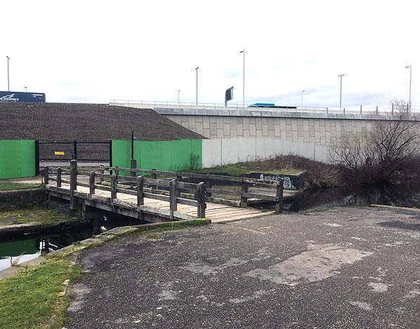
The line through the site of Runcorn Gap station was taken out of use on 4 November 1968 and it had been lifted to a point just south of Ann Street by 1970. In the early 1980s the site of the station was landscaped as a second phase in the creation of the Spike Island public park. The swing bridge was removed as it was found to be in very poor condition. It was replaced with a timber bridge.
In December 2014 work began on the Mersey Gateway road bridge. The northern approach viaduct for the bridge cut through the site of the station. The Mersey Gateway opened in October 2017.
Sources:
- The St Helens Railway, Its Rivals and Successors – J M Tolston – The Oakwood Press 1982
- The Widnes to St Helens Railway in Halton 1833 - 1982 - P T Wright - Halton Borough Council 2008
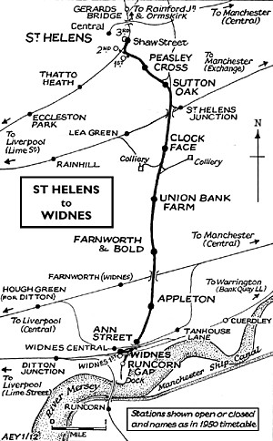
To see the other
stations on Widnes - St. Helens line click on the station name: Widnes 1st, Widnes South, Ann Street, Appleton, Farnworth
& Bold, Union
Bank Farm Halt, Clockface, Sutton Oak, Peasley Cross, St Helens 1st, St Helens 2nd & St Helens 3rd
And see related features:
Widnes Dock Junction and Widnes Dock and Marsh Sidings |

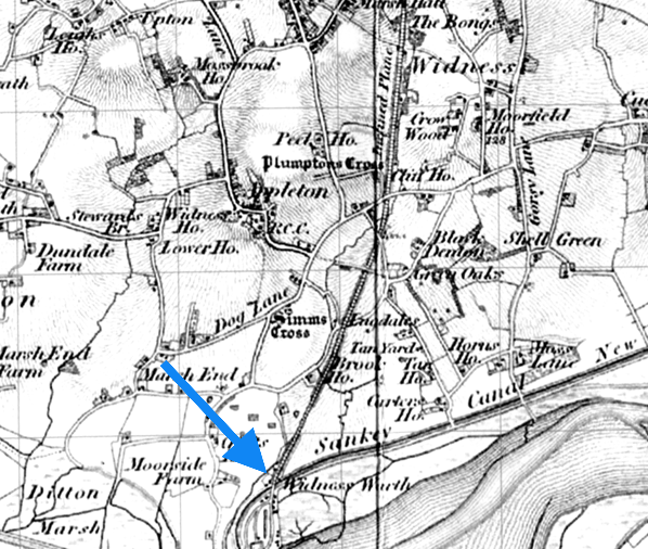
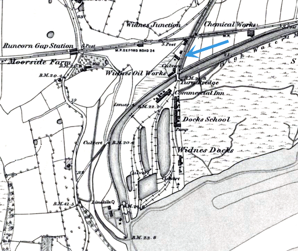 The site of the first Runcorn Gap station indicated by a blue arrow on a 6-inch scale map from 1852. Facilities including an inn had developed around the station since it had opened in 1833. The Garston and Warrington line is seen to the north. The second station (renamed Widnes in 1864) was located on that line and it can be seen to the west.
gap_old4.jpg)
.jpg)

 Home Page