
Station Name: NEWCASTLE NEW BRIDGE STREET
[Source:
Alan Young]
| Date opened: |
27.6.1864 |
| Location: |
Obliterated by A167(M) and slip road just north of New Bridge Street bridge. Part of the site is now occupied by the car park for Newcastle Business School (part of Northumbria University) |
| Company on opening: |
Blyth & Tyne Railway |
| Date closed to passengers: |
1.1.1909 (replaced by Manors North) |
| Date closed completely: |
4.12.1967 |
| Company on closing: |
Passengers: North Eastern Railway
Goods: British Rail (Eastern Region) |
| Present state: |
Demolished |
| County: |
Northumberland |
| OS Grid Ref: |
NZ253646 |
| Date of visit: |
July 1962, January 1973, September 1991 |
Notes: The Blyth & Tyne Railway reached Newcastle in 1864 with its terminus on the edge of the city centre, some 300 yd north of the North Eastern Railway’s Manors station, and 200 yd north of that company’s Trafalgar Goods depot.
 |
For its Newcastle terminus the Blyth & Tyne Railway adopted the existing Picton House, in Picton Place. This handsome villa was designed c1830 by the prominent Newcastle architect John Dobson (who designed Newcastle Central station). It was to accommodate the B&T offices and provide living quarters for the Manager. Picton House was a modest, |
but stylish, Italianate structure in ashlar, with pilasters and a hipped roof.
The OS 25” map of 1896 shows the station’s island platform, with a side platform to its west, adjacent to the main building. There were several sidings to the east, as well as to the north, where there was a two-road engine shed.
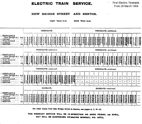
| The station was served by Tynemouth and Morpeth trains. In 1871 weekday departures amounted to only eight trains to Tynemouth and four to Morpeth, increasing to twelve to Tynemouth six years later. For the last few years of its life, New Bridge Street’s passenger service was transformed. From 29 March 1904 electric trains ran every fifteen minutes to Benton, |
 |
with half continuing around the Coast Circle through Whitley Bay, Tynemouth and Wallsend to Newcastle Central.
 |
On 1 January 1909 New Bridge Street closed to passengers and trains were diverted to the new Manors North. The four tracks of the newly completed Coast Circle cut down through the New Bridge Street site and also through the large Trafalgar Goods depot; Manors North was constructed partly on the site of that depot. Despite being bisected by the Coast Circle |
line, New Bridge Street was retained as a goods station. It expanded to the west, necessitating the demolition of most of Picton Place (but not Picton House), and to the east. On the eastern site a massive, futuristic reinforced concrete goods warehouse was constructed, designed by NER Chief Architect William Bell. Although seriously damaged by an air raid in 1941 much of the structure survived beyond withdrawal of goods services in 1967 and was not demolished until the 1980s. Picton House was demolished in 1970.
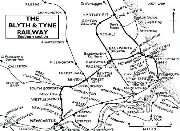 |
BRIEF HISTORY OF BLYTH & TYNE RAILWAY (Newcastle [New Bridge Street] – Jesmond – Benton – Backworth)
The southern end of the Blyth & Tyne Railway has a complicated history. Until 1861 there was a single route from Blyth and Seghill onward through Prospect Hill to Percy Main, with a terminus adjacent to the NER station. However in that year a new branch was opened, following the route of the former Whitley Waggonway, extending from Hartley to Tynemouth. It should be noted that this included the stretch to what is now Monkseaton, which was to be known as the ‘Avenue Branch’, and that the line beyond to Tynemouth was half a mile inland of the present day Monkseaton – Tynemouth Metro line.
At the Tynemouth end the original terminus was quickly replaced with a new one on a short branch which curved south eastwards, and that in turn closed when its branch was extended to a third terminus, which adjoined the 1847 Tynemouth terminus of what had been the Newcastle & North Shields Railway.
| In 1864 the Blyth & Tyne reached Newcastle, with a terminus at New Bridge Street. This was achieved by diverting trains onto a new line just south of Holywell, then through Backworth, Benton, and Jesmond. At Backworth a new line was opened to join the 1861 Whitley (Monkseaton) to Tynemouth route. Trains could now travel on the B&T from Newcastle (New |
1.gif.gif) |
Bridge Street) to Tynemouth, making the Holywell – Prospect Hill – Percy Main route, and the ‘Avenue Branch’ between Hartley and Whitley (Monkseaton) redundant. These two lines closed in June 1864 on the day when the Newcastle – Tynemouth service was inaugurated.
 |
In 1874 the B&T was absorbed by the NER, and the opportunity was taken to reorganise the railway routes in the Monkseaton / Whitley / Tynemouth area. With the growth of housing and holidaymaking on the coast the ‘inland’ route from Monkseaton to North Shields was superseded in 1882 by one within sight of the sea, and the two formerly competing termini at Tynemouth |
were replaced with a splendid new through station. This created the coastal section of the familiar Coast Circle and Metro route, although there were to be realignments at Whitley Bay in 1910 and Monkseaton in 1915 where new, larger stations were built.
In response to the growth and electrification of street tram networks on North Tyneside the Coast Circle route via both Wallsend and Carville was electrified in 1904 on the third rail system, and the irregular and infrequent steam service was replaced with a frequent interval service. For almost six decades the basic pattern was three trains per hour in each direction, with extras in the rush hour.
.gif) |
In 1963 the Reshaping of British Railways (‘Beeching’) report made no reference to the main Coast Circle line, but the Riverside Branch, via Carville, was recommended for closure (which was eventually implemented in 1973). However on a visit to Tyneside shortly after the report’s publication Beeching made it clear that the Coast Circle line was a likely candidate for closure. In the mid 1960s the ageing electric multiple units, dating from 1937, were being allowed a few more minutes to complete their journeys, and the decision was made to replace them with diesel multiple units cascaded from other areas rather than with newer electric stock. In June 1967, shortly after the line became part of British Rail’s Eastern Region – the North Eastern having been abolished - the last EMUs ran, and the third rails were removed.
| The service of three stopping trains per hour in each direction was replaced with a half-hourly service, plus one ‘express’ serving only the coastal stations, Wallsend and Manors; it is no surprise that custom was lost at the stations whose service was cut. However in October 1970 the tide turned, and the Eastern Region launched the vigorous Tynerider campaign to revitalise the line (including the Riverside branch) and the South Shields branch. Although the Riverside continued to have a sparse service at rush hours only, the Coast Circle’s 20-minutely service returned, with the new feature of trains in the early hours to bring revellers home from Newcastle city centre. Passenger numbers increased dramatically, and strengthened the case for further investment. The idea of incorporating the local railways into a rapid transit system was examined, and in 1973 Royal Assent was obtained to use the |
 |
Coast Circle as the basis of such a network, which was to become the Tyne & Wear Metro.
The engineering work to bring about this transformation was ambitious, involving the driving of tunnels under central Newcastle and Gateshead and constructing a sixth bridge over the Tyne between these centres, so that the Metro could be separated from the ‘main line’ system. For some time between January 1978 and November 1982 all of the stations on the Coast Circle (except Tynemouth) were closed for conversion work to be done: this included West Jesmond, South Gosforth, Longbenton, Benton, and West Monkseaton on the former B&T Newcastle route, thus their inclusion in the list of Disused Stations. Backworth closed in 1977 and Manors North in 1978 and were not to reopen on the new Metro line (although Manors underground station replaced Manors North, and Northumberland Park was opened in 2005 immediately south-west of the site of Backworth).
Almost all of the Newcastle – Backworth route remains as part of the Metro system. Only at the southern end has there been any significant change. A short distance north of the original Jesmond station the Metro route of 1980 curves to the south-west to enter the tunnel beneath central Newcastle and the new Jesmond station.
Click here for a list of sources and a Blyth & Tyne bibliography
Tickets from Michael Stewart except 8219 CJ Dean and goods labels from Brian Johnson. 1906 Bradshaw from Chris Hind, Electric timetable from Alan Young. Route map drawn by Alan Young.
To see other stations on the Blyth & Tyne Railway Newcastle - Backworth line click on the station name: Manors North, Jesmond, West Jesmond*, Moor Edge, South Gosforth*, Longbenton*, Benton (1st site)*, Benton (2nd site)*, Forest Hall (B&T), Benton Square and Backworth (2nd site).
* Station reopened as part of the Tyne & Wear metro. Three other Metro stations on this line are new sites and are not included. These are Palmersville, Northumberland Park and Ilford Road. |
street_old13.jpg) Official party and guests preparing to board the inaugural special train at New Bridge Street on 29 March 1904. NER Chairman, George Gibb, is on the left, facing the camera and holding a newspaper
Photo from Ken Hoole collection
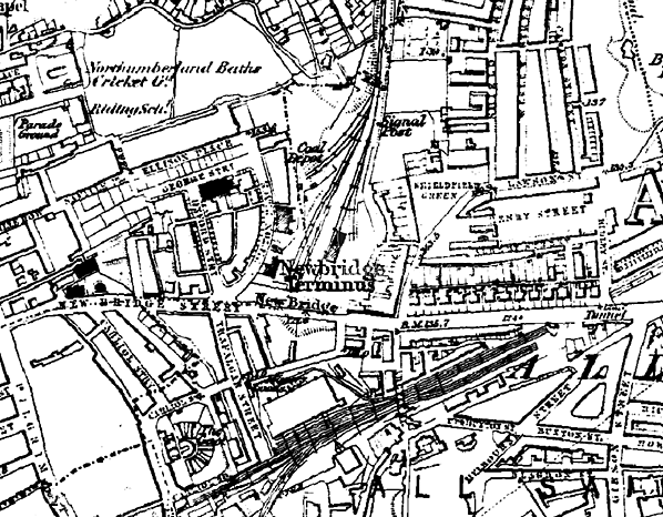
 1861 1:500 OS Town Plan. New Bridge Street (‘Newbridge’) station is shown as complete, although it was not opened until June 1864. Picton House, an existing property which was adopted as the station building, is in the extreme south-west of the map; it also contained the offices of the B&T and served as the residence of the company’s manager. The three platforms – a side platform, with a siding and turntable behind its northern end, and an island platform – can be clearly seen. The goods facilities are directly east of the passenger station
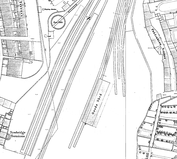
1864 1:10,500 OS Map. New Bridge Street station - ‘Newbridge Terminus’ - which opened in 1864 is shown, with its tracks leading north towards Jesmond. ‘Terminus’ was never part of the station name, and was simply a description frequently added by the Ordnance Survey to such stations. Manors station, later remodelled as Manors (East), is seen a short distance south-east of New Bridge Street. To the west of Manors the large Trafalgar Goods Depot can be seen, with its associated trackwork. This depot was demolished when the route from New Bridge Street was extended south in 1909, with Manors (North) occupying its site,
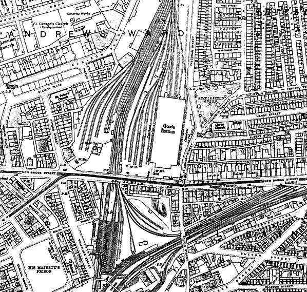
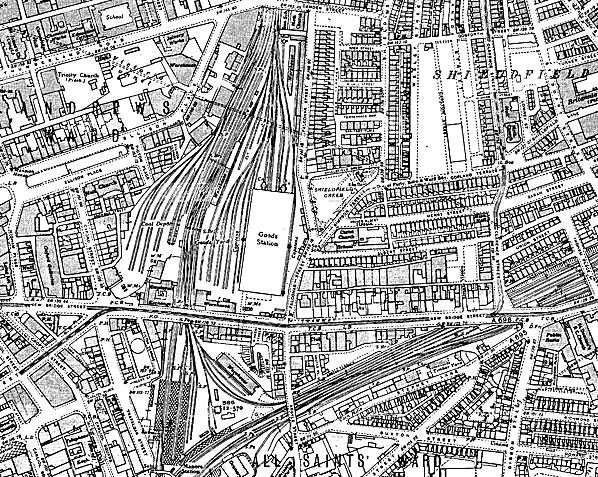
1919 1:2,500 OS Map. In 1909 the north-south route through Manors (North) was opened, and it sliced through the site of the New Bridge Street terminus station. This bisected the old station, with the former passenger platform area, which was converted into goods sidings, detached from the main, and expanded, goods area to the east. The huge goods warehouse, designed by William Bell in 1903, and built in ferro-concrete dominates the eastern site. Manors (North) and the earlier Manors (East) are shown simply as ‘Manors Station’. A north-to-east chord, allowing through movement of stock between Jesmond and Heaton, is shown. Picton House, which served as the station building for New Bridge Street station as well as the Blyth & Tyne company offices, remains in situ on this map.
1940 1:2,500 OS Map. In most respects the layout in the Manors / New Bridge Street area is unchanged from 1919, but a further goods warehouse and sidings have been added, reached from the
north-east chord
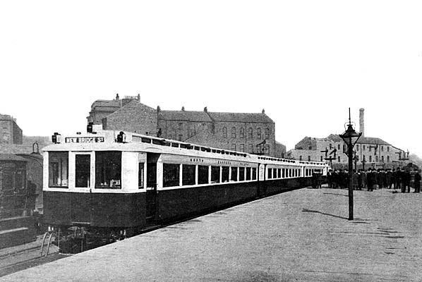 New Bridge Street station looking north on 29 March 1904. The inaugural run of the electric service from to Benton is about to take place, and the official party and guests are foregathering on the island platform. A splendid gas lamp can be seen in the foreground. New Bridge Street station looking north on 29 March 1904. The inaugural run of the electric service from to Benton is about to take place, and the official party and guests are foregathering on the island platform. A splendid gas lamp can be seen in the foreground.
Photo received from Mick Clark
street_old5.jpg)
New Bridge Street, looking north from the island platform, with a 1904 emu in a siding. The tracks in the background were the goods facilities, but the 1909 link between Jesmond and Manors North (running parallel to these sidings) was excavated through this site.
Copyright photo from John Alsop collection
street_old4.jpg)
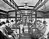
One of the 1904 electric multiple units at New Bridge Street
Copyright photo from John Alsop collection
street_old12.jpg)
Car 3250 derailed at New Bridge Street (before 1909). The Gateshead steam crane
has come to the rescue
Photo from Ken Hoole collection
The interior of New Bridge Street goods warehouse (completed 1912). This view shows the first floor with a turntable that will take a 42-ton loaded wagon.
Copyright photo from John Alsop collection
street_old1.jpg)
The goods warehouse, designed by William Bell in 1903 and completed in 1912. This huge ferro-concrete structure is seen from the south-west. The office building, whose style could not be more different, stands in front.
Photo
from John Mann collection
street_old8.jpg)
Picton House, the former New Bridge Street passenger terminus, looking north-east in 1949. In the background the ferro-concrete warehouse (completed 1912) can be seen in its damaged condition, following wartime bombing and a disastrous fire in 1941.
Copyright photo from John Alsop collection
street_old2.jpg) Looking south towards New Bridge Street goods station. The four tracks which curve gently to the right and descend lead into Manors North; the right-hand pair have third rails for the Coast Circle electric services. In the background (left) is New Bridge Street goods warehouse, reduced in height after it was severely damaged in a WWII bombing raid in September 1941; it is served by a complex network of tracks. The post-war office block, on New Bridge Street, is just visible to the right of the concrete building. It was a Heinz warehouse which BR bought and let to local fruiterers, while the upstairs was used as BR offices, instead of the upstairs of the pub over the road, which the offices had gone into after the bombing in 1941. The low warehouse on the right of the goods yard, with a signal gantry over the passenger lines to its right, is the McVitie depot. Biscuits and cakes came from Gorgie (Edinburgh) in swap bodies, which were transferred by fork lift to delivery van chassis here. The tracks on the extreme right lead towards the former New Bridge Street passenger terminus, and are
in use as goods sidings
Photo
by Brian Johnson
street_old9.jpg)
This view is looking north and was taken from the BR office in April 1963. It shows the coal yard clearly, which extended left to Picton House and covered the passenger station site
Photo
by Brian Johnson
The site of the New Bridge street passenger platforms was later occupied by a coal yard as seen in this view from the late 1960s. Picton House is seen to the rear.
Photo
by J C Dean
street2.jpg)
The south façade of the elegant Picton House, formerly serving New Bridge Street station and accommodating the B&T offices, during demolition in April/May 1970. The ‘Central Motorway East’ (now A167M) required its site. It is ironic that the name of John Dobson, the architect of this building, is immortalised in a particularly unattractive thoroughfare, opened a short distance to the west about the same time that Picton House was removed.
Photo from Stafford Lindsey collection, copyright Sine Project
Although closed in 1967 New Bridge Street goods depot survived in a derelict state until the 1980s. This view is from January 1973.
Photo
by Alan Young
street.jpg)
Aerial view showing the site of New Bridge Street station c.2008. The station was diagonally positioned where the off slip road is seen the the west of the roundabout. The new alignment of the B & T into Manors North bisected the station site. This line can be seen between the motorway and the City Campus of Northumbria University. Picton House was to the left, where the roundabout is now seen, while the platforms extended into what is now the university car park.
street6.jpg)
Looking north from the on slip road towards the site of New Bridge Street station in May 2012. The station was at a much lower level. The bridge is the off slip road for the motorway. The B & T line into Manors and Newcastle Central is covered over at this point.
Click on thumbnail to enlarge
| Last
updated: Sunday, 21-May-2017 16:03:17 CEST |
© 1998-2012 Disused Stations
| |
street_old6.jpg)
street_old12.jpg)
street8.jpg)
street_old_thumb6.jpg)
street_old_thumb10.jpg)
street_old_thumb11.jpg)
street_thumb1.jpg)
street_old_thumb3.jpg)
street_thumb3.jpg)
street_thumb4.jpg)
street_thumb5.jpg)
street_thumb7.jpg)

 Home Page