Note: Blyth & Tyne timetables refer to the station as Long Benton; a B&T system map published between 1864 and 1871 calls it Longbenton; and the OS 1:10,560 map of 1865 and Bradshaw render its name as Benton. The later Longbenton station (opened 1947) is about half a mile west of the 1864-71 site.
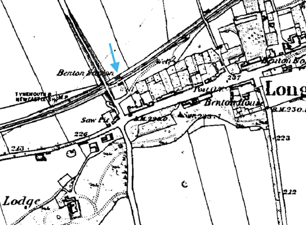
The station stood in a rural location adjacent to the village of Longbenton. The main building was south of the tracks: a simple brick structure with a pitched roof, it survived into the twentieth century. By the 1960s a cleared area of level ground and an NER style platform fence south of the tracks were all that remained. In 1871, the present-day Benton station on the Metro route was opened midway between Benton (B&T 1st) and Forest Hall (B&T) as their replacement. Four Lane Ends Metro interchange station now occupies the site.
BRIEF HISTORY OF BLYTH & TYNE RAILWAY (Newcastle [New Bridge Street] – Jesmond – Benton – Backworth)
The southern end of the Blyth & Tyne Railway has a complicated history. Until 1861 there was a single route from Blyth and Seghill onward through Prospect Hill to Percy Main, with a terminus adjacent to the NER station. However in that year a new branch
was opened, following the route of the former Whitley Waggonway, extending from Hartley to Tynemouth. It should be noted that this included the stretch to what is now Monkseaton, which was to be known as the ‘Avenue Branch’, and that the line beyond to Tynemouth was half a mile inland of the present day Monkseaton – Tynemouth Metro line.
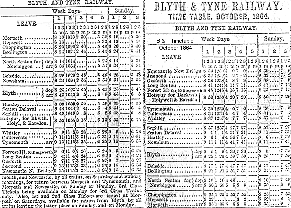 Benton station is shown as Longbenton in this 1863 B & T timetable
 |
At the Tynemouth end the original terminus was quickly replaced with a new one on a short branch which curved south eastwards, and that in turn closed when its branch was extended to a third terminus, which adjoined the 1847 Tynemouth terminus of what had been the Newcastle & North Shields Railway.
In 1864 the Blyth & Tyne reached Newcastle, with a terminus at New Bridge Street. This was achieved by diverting trains onto a new line just south of Holywell, then through Backworth, Benton, and Jesmond. At Backworth a new line was opened to join the 1861 Whitley (Monkseaton) to Tynemouth route. Trains could now travel on the B&T from Newcastle (New Bridge Street) to Tynemouth, making the Holywell – Prospect Hill – Percy Main route, and the ‘Avenue Branch’ between Hartley and Whitley (Monkseaton) redundant. These two lines closed in June 1864 on the day when the Newcastle – Tynemouth service was inaugurated.
In 1874 the B&T was absorbed by the NER, and the opportunity was taken to reorganise the railway routes in the Monkseaton / Whitley / Tynemouth area. With the growth of housing and holidaymaking on the coast the ‘inland’ route from Monkseaton to North Shields was superseded in 1882 by one within sight of the sea, and the two formerly competing termini at Tynemouth were replaced with a splendid new through station. This created the coastal section of the familiar Coast Circle and Metro route, although there were to be realignments at Whitley Bay in 1910 and Monkseaton in 1915 where new, larger stations were built.
In response to the growth and electrification of street tram networks on North Tyneside the Coast Circle route via both Wallsend and Carville was electrified in 1904 on the third rail system, and the irregular and infrequent steam service was replaced with a frequent interval service. For almost six decades the basic pattern was three trains per hour in each direction, with extras in the rush hour.
 |
In 1963 the Reshaping of British Railways (‘Beeching’) report made no reference to the main Coast Circle line, but the Riverside Branch, via Carville, was recommended for closure (which was eventually implemented in 1973). However on a visit to Tyneside shortly after the report’s publication Beeching made it clear that the Coast Circle line was a likely candidate for closure. In the mid 1960s the ageing electric multiple units, dating from 1937, were being allowed a few more minutes to complete their journeys, and the decision was made to replace them with diesel multiple units cascaded from other areas rather than with newer electric stock. In June 1967, shortly after the line became part of British Rail’s Eastern Region – the North Eastern having been abolished - the last EMUs ran, and the third rails were removed.
The service of three stopping trains per hour in each direction was replaced with a half-hourly service, plus one ‘express’ serving only the coastal stations, Wallsend and Manors; it is no surprise that custom was lost at the stations whose service was cut. However in October 1970 the tide turned, and the Eastern Region launched the vigorous Tynerider campaign to revitalise the line (including the Riverside branch) and the South Shields branch. Although the Riverside continued to have a sparse service at rush hours only, the Coast Circle’s 20-minutely service returned, with the new feature of trains in the early hours to bring revellers home from Newcastle city centre. Passenger numbers increased dramatically, and strengthened the case for further investment. The idea of incorporating the local railways into a rapid transit system was examined, and in 1973 Royal Assent was obtained to use the Coast Circle as the basis of such a network, which was to become the Tyne & Wear Metro.
The engineering work to bring about this transformation was ambitious, involving the driving of tunnels under central Newcastle and Gateshead and constructing a sixth bridge over the Tyne between these centres, so that the Metro could be separated from the ‘main line’ system. For some time between January 1978 and November 1982 all of the stations on the Coast Circle (except Tynemouth) were closed for conversion work to be done: this included West Jesmond, South Gosforth, Longbenton, Benton, and West Monkseaton on the former B&T Newcastle route, thus their inclusion in the list of Disused Stations. Backworth closed in 1977 and Manors North in 1978 and were not to reopen on the new Metro line (although Manors underground station replaced Manors North, and Northumberland Park was opened in 2005 immediately south-west of the site of Backworth).
Almost all of the Newcastle – Backworth route remains as part of the Metro system. Only at the southern end has there been any significant change. A short distance north of the original Jesmond station the Metro route of 1980 curves to the south-west to enter the tunnel beneath central Newcastle and the new Jesmond station.
Click here for a list of sources and a Blyth & Tyne bibliography
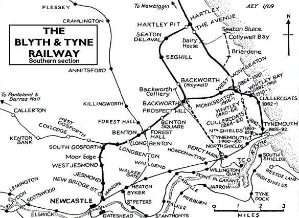
B & T timetable from CJ Dean. Route map drawn by Alan Young.
To see other stations on the Blyth & Tyne Railway Newcastle - Backworth line click on the station name: Newcastle New Bridge Street, Manors North, Jesmond, West Jesmond*, Moor Edge, South Gosforth*, Longbenton*, Benton (2nd site)*, Forest Hall, Benton Square and Backworth (2nd site).
* Station reopened as part of the Tyne & Wear metro. Three other Metro stations on this line are new sites and are not included. These are Palmersville, Northumberland Park and Ilford Road. |

1st_old1.jpg)
1st4.jpg)
1st2.jpg)
1st3.jpg)
1st1.jpg)

 Home Page