Thornley station served the village of Thornley, County Durham although it was some distance from the village and much closer to Wheatley Hill so it's unclear why it was named Thornley.
 The Hartlepool Dock and Railway Company was incorporated under act of 1 June 1832 receiving Parliamentary approval to construct a passenger/freight line from Hartlepool to Haswell (via Hart, Hesleden, Wellfield and Shotton) with the intention of eventually pushing through to Pittington, Moorsley, Rainton and beyond and hopefully diverting coal trade from collieries en route such as the new ventures at Haswell and South Hetton towards Hartlepool. The line was only completed as far as Haswell. A rival company, The Sunderland Dock & Railway received Royal Assent on 13 August 1834 for a line from Sunderland (Town Moor) - Sherburn along with a branch to Haswell. The directors of this line were unconvinced by the early locomotives produced by George Stephenson and others and instead opted for fixed engines which could manage some of the steepest gradients on the British Railway network far better. From Sunderland to Ryhope, which was flat, the trains were hauled by a locomotive. There the loco was replaced by a chain connected to the fixed engine house at Murton Junction. At Murton the chain was changed for another one connected to Haswell fixed engine house. It was barely quicker than walking but this method of transport was used some 20 years after the development of powerful locos which could do the entire journey on their own regardless of the gradients. The Hartlepool Dock and Railway Company was incorporated under act of 1 June 1832 receiving Parliamentary approval to construct a passenger/freight line from Hartlepool to Haswell (via Hart, Hesleden, Wellfield and Shotton) with the intention of eventually pushing through to Pittington, Moorsley, Rainton and beyond and hopefully diverting coal trade from collieries en route such as the new ventures at Haswell and South Hetton towards Hartlepool. The line was only completed as far as Haswell. A rival company, The Sunderland Dock & Railway received Royal Assent on 13 August 1834 for a line from Sunderland (Town Moor) - Sherburn along with a branch to Haswell. The directors of this line were unconvinced by the early locomotives produced by George Stephenson and others and instead opted for fixed engines which could manage some of the steepest gradients on the British Railway network far better. From Sunderland to Ryhope, which was flat, the trains were hauled by a locomotive. There the loco was replaced by a chain connected to the fixed engine house at Murton Junction. At Murton the chain was changed for another one connected to Haswell fixed engine house. It was barely quicker than walking but this method of transport was used some 20 years after the development of powerful locos which could do the entire journey on their own regardless of the gradients.
Before the Hartlepool Dock line was officially opened, the company gave Messrs Wilkinson and Walker permission to run a passenger coach from Hartlepool to Haswell on Sundays on payment of 6/- per day. If immediately implemented, the first ‘train’ would have run 24 July 1836. On 26 October, the same parties were licensed to run daily. This would have run from the dock area at Hartlepool; no other details are known. This is an unusual example of a line having a Sundays-only service at opening. It was probably for church-goers and there were other examples of this in the area. The service would presumably have been horse-drawn.

The line between Sunderland and Haswell opened on 30 August 1836 but only for coal traffic. The initial, interim, passenger service ran only between Town Moor and Ryhope and in April 1837 through to Haswell where passengers could change stations to reach Hartlepool with The Hartlepool Dock and Railway Company opening on 1 May 1839 from Hartlepool to Hart, Hesleden, Castle Eden, Thornley and Haswell. Although the Durham & Sunderland line and Hartlepool & Dock Co lines both terminated at Haswell, there were two separate stations at right angles to each other and on different levels. The lines were eventually joined with a curve in 1855 but there were still two stations until a new through station opened on 1 November 1877.
 These maps of Haswell represent 1856 at the top and 1898 at the bottom. Haswell is some three miles north of Thornley Junction, the two locations being linked by Salters Lane, and has an interesting albeit somewhat complicated railway history. Referring to the 1856 map the Durham & Sunderland (D&S) is the line coming in from the north north-east, to the left of the Haswell & Seaham Waggonway which came down via the junction at South Hetton. Coming in from the south-east is the Hartlepool Dock & Railway Co's line which passed over the top of the D&S. A timetable from March 1850 shows a through Hartlepool - Sunderland service via Haswell and, of course, Murton but quite what happened with these trains at Haswell is unclear; the "Railway Station" marked on the map was the Hartlepool Co's station. It is possible trains used the connecting link with its sharp curve which would also have involved a reversal. The only other possible situation was passengers having to alight from the Hartlepool Co's train and board a D&S train. The D&S line was originally rope worked by means of winding engines located at intervals. It should also be noted that the two lines were on different levels, the Hartlepool Co. line being at the higher level. Whether the D&S provided any form of station or if it shared the Hartlepool Co's buildings is lost in the mists of time although the latter possibility is implied by the map. The D&S line was known as the "Haswell Branch" and was the reason for Murton being a junction. The line can be seen on both maps disappearing off the bottom left corners. It ended at Haswell Colliery which was situated just off the bottom of the maps. Haswell Colliery closed in 1896 and its tragic story can be read here here. Staying with the 1856 map for a further few moments, two Public Houses are shown; The Railway Tavern and The Railway Coach. Both have long since ceased trading and the building that was The Railway Coach no longer exists. Quite why the word "Coach" was used is unclear bit it may have been a reference to early horse-drawn railway carriages which resembled stage coaches on railway wheels. Coming into view on both maps is North Pespool. Today the name is spelled "Pesspool" and Pesspool Lane is an eastward continuation of Station Street. The earthworks seen heading north-west from the Hartlepool Co's station were the remnants of a proposed extension to Durham which was destined never to be built. The earthworks petered out after about one-third of a mile. Moving forward in time to the 1898 map it can be seen a connecting chord has been installed and the stub of the Hartlepool Co. line to the earlier terminus abandoned. The chord and the new, through, station had opened in 1858 and with it came the end of rope haulage. As can be seen the new chord bisected the by-then-abandoned formation of the Haswell & Seaham Wagonway. The siding down to the former Haswell Colliery is shown as still in situ and access was via a siding connection and reversal on the headshunt created by the original Durham & Sunderland line's disconnection from the new chord. One may wonder why a connection was not retained to give direct access, although a reversal would still have been necessary. The probably answer is that wagons (for the gasworks) were tripped from the new station's goods yard seen at lower right and the track layout avoided too much disruption to the main line which, back in the day, was very busy with coal traffic let alone passenger and other goods traffic. The map suggests the gasworks had a small dock at the northern tip of its site. This was a very small gasworks and the Haswell Gas Light Company was dissolved in 1916 although whether the gasworks ceased operation at the same time or was taken over is unclear. Certainly maps show the gasworks had gone by 1939 and the track serving it lifted, although the sidings north of the [1858] station remained. In 2025 evidence of the former railways and wagonways in Haswell and its surrounding area can still be seen from the air but on the ground in respect of Haswell itself very little obvious evidence remains. Click here for a larger version
There were branches to Ludworth Colliery, Thornley Colliery, Shotton Colliery and Wheatley Hill Colliery. The Hartlepool Company began its own service from that date, when others’ licences were revoked. However, it didn't provide a Sunday service and in April 1840, Mr Humble was given permission to run one of the old coaches on Sundays, with a toll of 3d per mile.
The line was leased to the York, Newcastle and Berwick Railway Company for 31 years from 1 July 1848 under agreement dated 18 December, 1848 in pursuance of powers conferred by Act of 1848 and was dissolved and vested in North Eastern Railway Company under North Eastern and Hartlepool Dock and Railway Companies Amalgamation Act 13 July 1857. The Durham & Sunderland which included the Haswell branch was purchased by the Newcastle & Darlington Junction Railway under an Act of 27 July 1846. The N & DJR was renamed the York & Newcastle Railway and the following year it amalgamated with the York, Newcastle & Berwick Railway.
 It is unclear when a station at Thornley, at its junction with the Thornley Colliery branch was provided. A station at Thornley is shown on some early maps but didn't appear in Bradshaw until February 1858. Ken Hoole, in his book Railway Stations Of The North East, lists the opening year as 1835. The branch to Thornley Colliery served a number of collieries, notably Wheatley Hill and Ludworth. Other collieries served included Bowburn (c by 1894), Cassop Moor (c.1850s), Crow Trees (c. by 1894), Heugh Hall (c. by 1894) and West Hetton. The naming of the branch is confusing. At Thornley Junction Ordnance Survey show it as 'Thornley Branch' At Wheatley Hill Junction the 'Green Hills Railway' diverges to the west to serve Wheatley Hill Colliery. The Thornley Branch continues to Ludworth Junction where the Ludworth Branch diverges to the right to serve Ludworth Colliery while the Thornley Branch continues south west to Thornley Colliery. It is unclear when a station at Thornley, at its junction with the Thornley Colliery branch was provided. A station at Thornley is shown on some early maps but didn't appear in Bradshaw until February 1858. Ken Hoole, in his book Railway Stations Of The North East, lists the opening year as 1835. The branch to Thornley Colliery served a number of collieries, notably Wheatley Hill and Ludworth. Other collieries served included Bowburn (c by 1894), Cassop Moor (c.1850s), Crow Trees (c. by 1894), Heugh Hall (c. by 1894) and West Hetton. The naming of the branch is confusing. At Thornley Junction Ordnance Survey show it as 'Thornley Branch' At Wheatley Hill Junction the 'Green Hills Railway' diverges to the west to serve Wheatley Hill Colliery. The Thornley Branch continues to Ludworth Junction where the Ludworth Branch diverges to the right to serve Ludworth Colliery while the Thornley Branch continues south west to Thornley Colliery.
The Thornley Branch is listed as carrying passengers and appeared as such in the Railway Clearing House Handbook of 1877 but does not appear in the 1883 handbook. This is assumed to be a miners' service as the station was listed as Thornley Junction in Bradshaw between 1879 and 1882 and also in the 1880 North Eastern Railway timetable. A platform on the branch is clearly shown in the 1968 photo below. Thornley station never handled goods traffic although it did have a 'fish house'. Stations provided with a fish house catered for small quantities of fish, such as might be ordered by a local fishmonger. This could be easily manhandled and transported, usually by a passenger train. The fish would probably have been live in tanks, a fairly common practice in the North East.
Although there were no other goods facilities at Thornley, there was a public goods station in Thornley village on the colliery branch. The station had several buildings, a single siding and a two ton capacity crane. It was listed in the 1904 Railway Clearing House Handbook Of Stations as being at Thornley Colliery Station. It was still shown in the 1956 handbook. The goods station closed on 6 April 1964.

Thornley station comprised two facing platforms with a building at the south end of the up platform. The original buildings are shown on the 1897 OS map reproduced below but in 1910 a new building in three distinct parts along with four railway cottages and a station master's house was authorised at a cost of £1,654. These were built in 1911. In its early years, the station had its own station master but in later years a station master covered Thornley and Wellfield at various times and Thornley and Shotton Bridge at other times.
The main station building was of brick construction with a hipped slate roof and a gable at the north end facing the platform. The building included the booking hall, waiting room, which jutted into the station forecourt and a ladies room. A small brick building with a flat roof stood at the south end of the main building. This opened onto a lobby with the fish house straight ahead and the gents' toilets to the right. The ladies toilet was also in this building; this was accessed from the ladies' room. There was a door from the ladies' room onto the platform. The third slightly taller brick building with a sloping roof and chimney was divided into four rooms, one of which was probably a lamp room, another a staff rest room hence the chimney for a stove.
 There were two small waiting shelters facing each other. By the early 20th century these had been replaced by two new slightly offset 40' X 7' weather boarded waiting shelters with a sloping roof in typical NER style. These had bench seating along the rear and side walls and a central fire place. An open lattice footbridge spanned the platforms between the main station building and the waiting shelter was provided, probably at the same time as the new buildings. Access to the station was along a 616 yard track from the level crossing on the south side of Salters Lane. This ran along the south side of the Thornley Colliery branch with a bridge across the branch to the station entrance. This track and bridge did not appear on maps until the early 20th century so it is unclear how passengers accessed the station before then. In 1911 the station served a population of 3042 which included the villages of Thornley and Wheatley Hill. That year there were 43,306 tickets issued from the station. There were two small waiting shelters facing each other. By the early 20th century these had been replaced by two new slightly offset 40' X 7' weather boarded waiting shelters with a sloping roof in typical NER style. These had bench seating along the rear and side walls and a central fire place. An open lattice footbridge spanned the platforms between the main station building and the waiting shelter was provided, probably at the same time as the new buildings. Access to the station was along a 616 yard track from the level crossing on the south side of Salters Lane. This ran along the south side of the Thornley Colliery branch with a bridge across the branch to the station entrance. This track and bridge did not appear on maps until the early 20th century so it is unclear how passengers accessed the station before then. In 1911 the station served a population of 3042 which included the villages of Thornley and Wheatley Hill. That year there were 43,306 tickets issued from the station.
A tall NER Type N1 signal box was provided at the south end of the down platform by 1873. The original frame is not known but a replacement 16 lever Stevens frame was installed in 1893.
As part of the Railways Act of 1921 which created the 'Big Four' railway companies the North Eastern Railway became part of the London & North Eastern Railway on 1 January 1923. It operated until nationalisation on 1 January 1948. At that time, it was divided into the new British Railways' Eastern Region, North Eastern Region and partially the Scottish Region.
Thornley station closed on 9 June 1952 along with most of the stations on the Sunderland - Hartlepool line. The line continued to be busy with coal traffic. Wheatley Hill Colliery closed in May 1968 and Thornley Colliery in January 1970 so that would have brought an end to coal traffic on the branch (Ludworth Colliery had closed in 1934). The signal box closed on 7 January 1968.
A number of rail tours passed through Thornley after closure. These include The SLS/Manchester Locomotive Society Tees-Tyne Rail Tour on 2 September 1956, The SLS /Manchester Locomotive Society/Kings College Railway Society Durham Railtour on 13 October 1962 - this tour stopped at Thornley. The last railtour to pass through the station was the Branch Line Society Durham Area Railtour on 3 April 1971. Motive power for this tour was a Metro-Cammell DMU.
By the early 1970s the main line and the Thornley branch were singled and the station buildings and railway cottages were demolished. After the closure of Shotton Colliery in 1972 the only coal traffic left was from South Hetton. Some time in the mid 1970s the line through Thornley closed, with coal from South Hetton going north. With the line now closed to all traffic, the track was lifted in September/October 1979. In the early 1980s the Thornley Station Industrial Estate had been built to the north of the station between the main line and the Thornley Branch. The site of the station is now part of the Haswell to Hart Countryside Walkway and is on Route 14 of the Sustrans National Cycle Network. Thornley Station Household Recycling Centre has been built on the Thornley branch. Beyond the recycling centre a footpath leads along the branch to Thornley Junction which is the easiest access point to the station site.
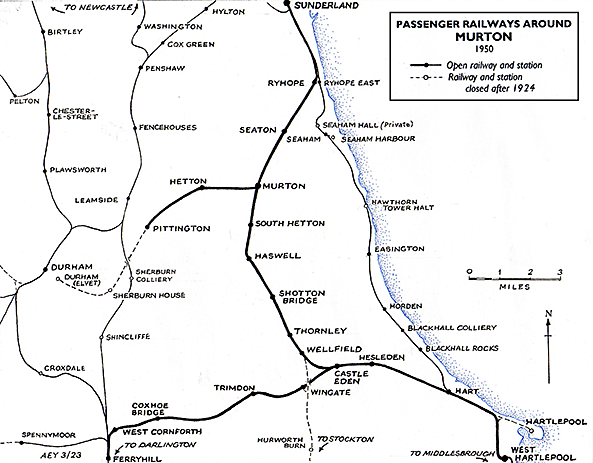
Tickets from Michael Stewart, Route map drawn by Alan Young
Sources and bibliography:
See also: South Hetton and Murton |


old1.jpg) Looking towards South Hetton circa 1920. Dominating the scene is the footbridge to the familiar North Eastern Railway style with lamps, oil in this case, on the landings although this particular footbridge was not quite as ornate as some. The wall-mounted lamp, far left, has a ladder propped against the wall. These lamps needing tending to on a daily basis although depending upon time of year and hours a station was open this could be 'stretched'. The waiting shelter just beyond the bridge and on the right was the only building on that platform.
Looking towards South Hetton circa 1920. Dominating the scene is the footbridge to the familiar North Eastern Railway style with lamps, oil in this case, on the landings although this particular footbridge was not quite as ornate as some. The wall-mounted lamp, far left, has a ladder propped against the wall. These lamps needing tending to on a daily basis although depending upon time of year and hours a station was open this could be 'stretched'. The waiting shelter just beyond the bridge and on the right was the only building on that platform.


 Home Page