|
Notes: Notes: The small town of Tow Law stands on an exposed hilltop on the edge of the North Pennines about 10 miles to the west of Durham. Until 1841 there was no settlement here of any size, only a single home, Tow Law House.
The development of Tow Law as a town started in 1845 when Charles Atwood took advantage of the local supply of iron ore and built an iron works close to Tow Law House.
Although the line opened on 1 September 1845, Crook was still listed as the terminus in Bradshaw until October 1846. On 7 January Charles Atwood attended a committee meeting of the Wear & Derwent Junction Railway, and he told them that his Weardale Iron Company expected to have six furnaces ready by April which would be capable of processing 300 tons of ironstone per week. This would generate more traffic for the new railway and, as the town developed around it, there would also be potential passenger traffic.
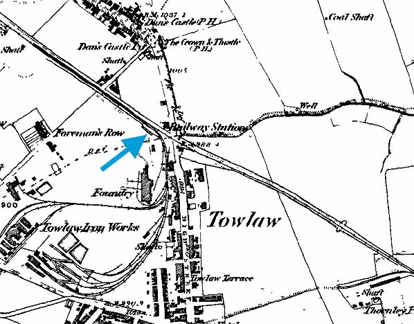
The first evidence of Tow Low in a public timetable is in September 1847 but there is a reference to the station in S&D company minutes of 11 March 1847 when it was reported that ‘accommodation was wanted for passengers’. There is no information about the station but from the map below it had a building on the north side of the line and a very short platform, little more than the length of the building.
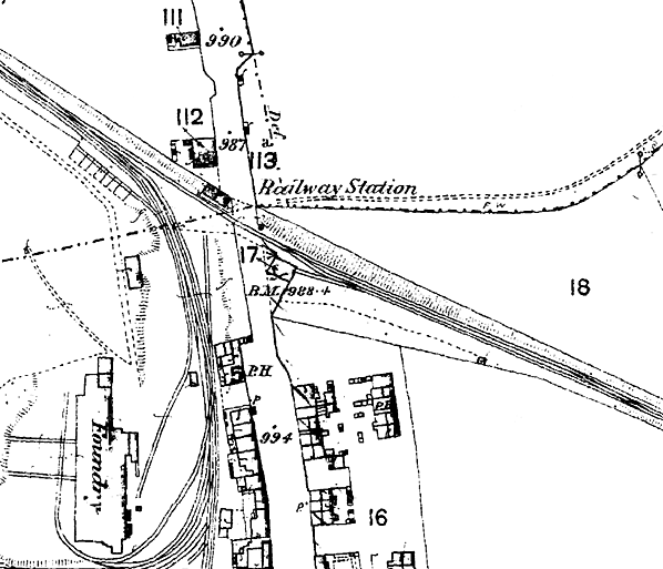
The station was short-lived and was re-sited on 2 March 1868 when the Sunniside (or Sunnyside) incline was replaced with a deviation
BRIEF HISTORY OF THE BISHOP
AUCKLAND TO BLACKHILL LINE
The western section of the Stockton and Darlington Railway had been progressively improved and extended with the Bishop Auckland & Weardale Railway finally reaching Crook in 1843. The BA&W company minutes show that the line opened to a permanent station at Bishop Auckland on 30 January 1843, ahead of the rest of the line to Crook and that the generally quoted 8 November 1843 for opening to Crook was for goods only. The line was leased by the Stockton & Darlington Railway.
The following stations were proposed: South Church, Bishop Auckland, Escombe, Old Etherley Colliery, Low Bitchburn, Howden and Crook. The line opened to a temporary terminus at South Church on 19 April 1842 and extended to a permanent Bishop Auckland station on 30 January 1843. The line to Crook was authorised for opening on 3 January 1844 but the passenger opening date to has not so far been traced; however, the minutes do show that the line was inspected on 1 January 1844 and that permission to open for passengers was received by, on or before 6 January. Escombe and Low Bitchburn stations are never mentioned again and were probably never built.
It is likely that the initial service to Crook was market days only because, when it first appeared in Bradshaw in July 1844, only a Thursday market service was shown but the line was in full use by January 1845.
The Derwent Iron Company was looking for an outlet to the south and itself considered building a line towards Crook and the Stockton & Darlington Railway but in the end it was the S&D who constructed the Weardale Extension Railway from Crook, via the rope-worked Sunniside (or Sunnyside) incline to a station at Tow Law joining the former Derwent Railway at Waskerley, at the head of Nanny Mayor’s Incline where a small railway village developed on the top of the moors. The line was opened to traffic on behalf of Derwent Iron Company on the 16 May 1845; the company subsequently purchased the Derwent Railway.
Tow Law first appears in timetables in September 1847; references have been found to additional stops at High Souk (alias High Stoop) and Saltersgate Cottage, which would have been further north towards Burnhill. Although both stations appear on the early Ordnance Survey maps, passenger use cannot be confirmed.
The Bishop Auckland & Weardale Railway amalgamated with the Wear Valley Railway in 1847 which was, in turn, taken over by the Stockton & Darlington in 1858 and by the North Eastern Railway in 1863. On 2 March 1868 the Sunniside incline was replaced with a deviation to allow locomotive haulage, which required the re-siting of Tow Law station.
In NER days a through service was provided from Darlington to Tyneside via Bishop Auckland, Crook, Tow Law, Burnhill and along the Derwent Valley Line through Blackhill and Swalwell. With increasing competition from roads and the decline in the handling of lime and stone the line north of Tow Law to Blackhill (Consett) was closed to passengers on 1 May 1939 along with the stations at Burnhill and Rowley, ending through running to Tyneside. Shortly after closure the government built the Salters Gate Ammunition Depot across the line between Salters Gate and Burnhill which effectively totally closed the through line, although munitions trains could access the Burnhill Station transfer yard from both directions.
The line was further cut back to Crook on 11 June 1956 and the final section of line from Bishop Auckland - Crook closed to passengers on 8 March 1965. The track north of Wear Valley Junction was lifted in late 1967 or early 1968.
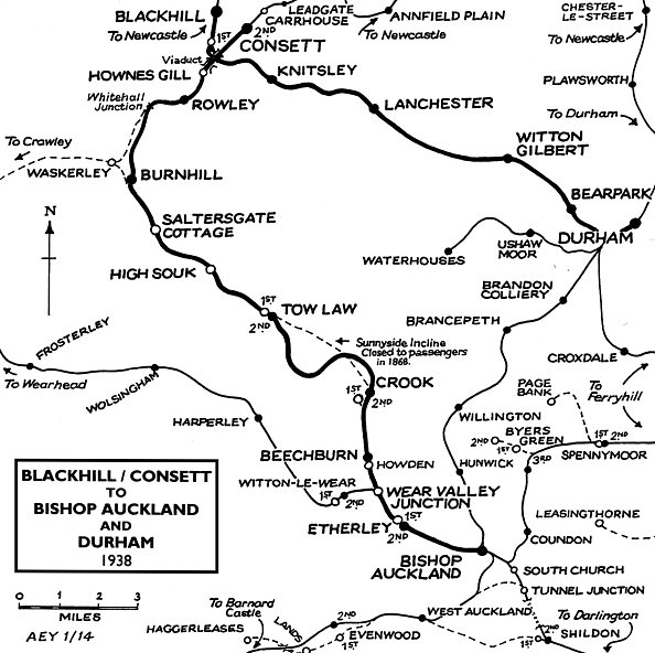
The line between Bishop Auckland and Crook served a number
of collieries and other industrial sites. Click here for a full list. Route map drawn by Alan Young.
Source:
To see the
other stations on the Bishop Auckland - Rowley line click
on the station name: Bishop
Auckland, Etherley,
Wear Valley
Junction, Beechburn,
Crook, Tow Law (2nd site), High
Souk, Saltersgate
Cottage, Burnhill
Junction (Military Exchange Station), Burnhill
& Rowley
See also stations
on the Wear Valley line to Wearhead
|

 Home
Page
Home
Page
