
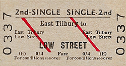
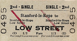
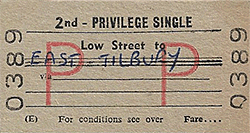
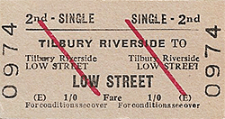
Station Name: LOW STREET[Source: Nick Catford]
street_ol1.jpg) A pre-WWI view facing north-west over Low Street level crossing with the station to the right. The then narrowness of the road is readily apparent as is the consequent arrangement of the level crossing gates. Partially visible at far left is the original signal box; very few photographs showing it have come to light. It was to be replaced in January 1925 and the reason why is fairly obvious. What is less obvious is that three tracks crossed the road, namely the Up and Down main lines and the Down goods loop. Two of the station's oil lamps can be seen, both with the actual lamps present in the casements. A ladder is propped against the nearest lamp, indicating it has either just been refilled with oil or is about to be. This task had to be undertaken in all weathers along with signal and level crossing lamps. The bracket signal was to remain in use well into the BR period, being replaced initially by a searchlight type colour-light signal. An open wagon can be seen on the right and the style of the letter 'G' suggests the wagon is of Great Eastern Railway origin. It is apparently standing upon the Down main line as the ramp of the Down platform is just visible behind and to the left of the wagon. A pre-WWI view facing north-west over Low Street level crossing with the station to the right. The then narrowness of the road is readily apparent as is the consequent arrangement of the level crossing gates. Partially visible at far left is the original signal box; very few photographs showing it have come to light. It was to be replaced in January 1925 and the reason why is fairly obvious. What is less obvious is that three tracks crossed the road, namely the Up and Down main lines and the Down goods loop. Two of the station's oil lamps can be seen, both with the actual lamps present in the casements. A ladder is propped against the nearest lamp, indicating it has either just been refilled with oil or is about to be. This task had to be undertaken in all weathers along with signal and level crossing lamps. The bracket signal was to remain in use well into the BR period, being replaced initially by a searchlight type colour-light signal. An open wagon can be seen on the right and the style of the letter 'G' suggests the wagon is of Great Eastern Railway origin. It is apparently standing upon the Down main line as the ramp of the Down platform is just visible behind and to the left of the wagon.Photo from John Mann collection 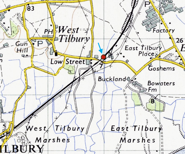 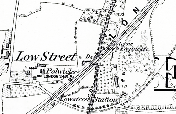
1865 1:10,600 OS map shows the layout of Low Street station as built. There is a loop siding on the down side and a short siding on the up side.
1897 1:2,500 OS map. The two facing platforms are seen with the short down platform opposite the station building. The goods yard is seen on the down side with the goods shed facing onto the loop siding. The siding runs over the level crossing at the south-west end of the station. A terrace of three railway cottages is seen top right.
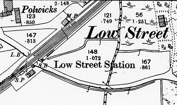
 1922 1:2,500 OS map. The two platforms have been coloured, the down platform being noticeably shorter than the up. This map shows the full extent of the sidings. The down siding is a loop running behind the platform and past a goods shed. On the up side one siding runs across Low Street to serve a gravel pit. There are two terraces of railway cottages with three cottages alongside the gravel pit siding and four cottages at the junction with the sidings on the up side. Click here to see a larger version of this map. Click here to see a larger version of this map.
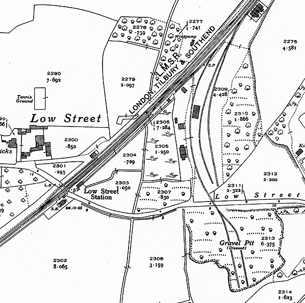
1947 1:2,500 OS map. Little has changed since the 1922 map. There are now two sidings in the gravel pit on the south side of Low Street but the pit is now shown as disused.
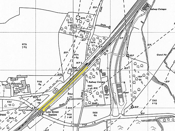
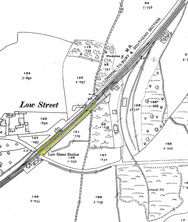
1961 1:2,500 OS map. Both platforms have now been extended and are coloured yellow. Officially the goods yard remained open until 28 September 1964 but this map shows the goods loop has been lifted back to, but not over, the level crossing to accommodate the platform extensions. The gravel pit siding has been lifted across the Low Street level crossing and the oil depot has been built between the two adjacent sidings. Both sets of railway cottages are identified. Click here for a larger version.
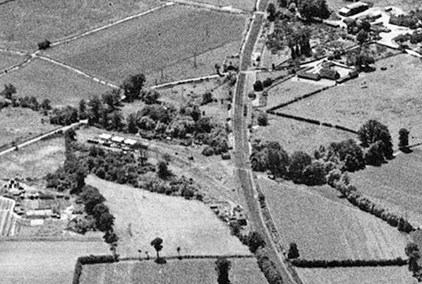 An aerial view of Low Street from July 1950. The camera is facing south-west. Low Street, now Station Road, comes in from the left and becomes Church Road after the level crossing. At top right Low Street Lane can be seen heading north-east, with Polwick's Farm in the corner formed by the road junction. Also visible is the access road to Low Street goods shed. The shed, alongside which some wagons can be seen. At the top of the image can be seen No.168 occupation crossing, still there today. Left of centre can be seen the oil storage facility, which itself provides a further mystery. Maps and plans show three sidings, two serving the storage tanks, one per side, plus a third which once crossed the road to serve a gravel pit. This view shows what appears to be an additional oil siding on the east side and some tank wagons can clearly be seen stabled on it. The siding which once crossed the road runs alongside the trees above the storage tanks but by this time stopped short of the road. The area around the oil storage tanks had itself once been occupied by gravel pits, these being the original reason for the provision of sidings. A number of cottages may be discerned. Those toward the bottom of the image adjacent to the junction with the oil sidings burned down in the early 21st century and at the time of writing still stood as derelict shells. They were described on plans as being railway cottages. A little beyond and in the 'V' formed by the junction can be seen a further cottage or a pair of. These were not shown on plans as railway cottages and were to disappear during the 1960s. There were further railway cottages in the wooded area above the oil storage tanks and the roof of one is just visible. These cottages also no longer exist. Today the area occupied by the oil storage tanks is used for cattle grazing and European Metal Recycling occupy the area toward the bottom of the image and to the left of the railway. One hint of the past which does still exist is the access road to the former railway cottages toward the bottom of the image. The road is now overgrown and blocked at its junction with Station Road.
Photo from Bratain from Above, reproduced with permission. Click here for a larger version. street_old2.jpg)
Looking north-west across Low Street level crossing c1956, a few years before electrification. The only station building was on the up side and comprised a simple brick bookingoffice. The signal box seen here replaced the original box seen above.
Photo from John Mann collection street_old3.jpg) Sometime during the 1950s an unidentified War Department 2-8-0, LNER/BR Class 07, passes Low Street with an Up goods train. A number of these locomotives were allocated to Plaistow and Tilbury sheds and thus were a common sight on the LT&S lines. The locomotive is passing the only building ever provided, relevant to passenger services, at Low Street. The level crossing was somewhat unusual. The road, once Low Street and today Station Road, was just a narrow lane and this resulted in a single crossing gate being provided each side of the tracks. The road was widened at some point during the second half of the 20th century and a full set of swing gates provided. Today the crossing is provided with four lifting barriers. The signal box depicted was provided in 1925, replacing an earlier structure and was commissioned on 4 January that year. To a Midland railway design, it is believed to have been provided new as opposed to second-hand from elsewhere. On the left the Down goods loop can be seen and, at extreme left, Low Street's small goods shed. This made the Down platform into an island, creating the illusion of Low Street having three platforms. The loop itself is something of a mystery as a reproduced version of a Midland Railway track plan of 1920 implies the loop, at that time, crossed the Down main line, foreground, via a diamond crossing to connect at points with the Up main line. If true it would have been a very awkward arrangement as Down goods trains would have to pass through the station and reverse into the loop. Up goods trains, however, could cross over as they approached the station and then enter the loop before continuing in the Up direction by the means described. No OS maps, or any other plans, have been found which confirm this arrangement, however, so the implication given by the 1920 track plan should be treated with caution.
Photo from John Mann collection )street_old4.jpg)
A rather gloomy and somewhat desolate view of Low Street, thought to date from the second half of the 1950s. The photographer is on the Up platform, facing towards Tilbury. The signal box is just visible in the left background, beyond the level crossing which carries what is today Station Road over the railway. Station Road was once Low Street, hence the station name, and today the only obvious evidence of the name is Low Street Lane, which is out of view to the right and runs parallel to the railway. The track behind the 'island' platform was the Down goods loop and it continued over the level crossing. The loop was present in the late 19th century and may have been installed at, or soon after, the time the station opened. Maps indicate the loop had been lifted back to, but not over, the level crossing by 1961. The short 'island' platform was to be lengthened with the coming of electrification, which went live on this stretch of the LT&S in November 1961 and this ties in with cartographic evidence regarding removal of the goods loop of which today no trace remains. A degree of mystery surrounds the platforms and it is thought the Down was some 80ft long and the Up some 200ft long originally. Somewhat curious is the provision of different types of oil lamp on the platforms. The level crossing was No.169, situated 24 miles 11 chains from Fenchurch Street.
Photo
from Jim Lake collection
)street_old5.jpg) War Department Class 07 2-8-0 No.90442 is seen on the Down goods loop at Low Street with a short train of 'Regent' tank wagons. The shedplate is unreadable but this locomotive had spent time at Plaistow and Tilbury sheds between May 1955 and December 1961 so we can date this image to that period and more likely to 1958 - 1959 as she carries a Class K headcode, indicating a local goods working, while the loop is still in situ and there is no obvious sign of electrification work having commenced. The tender still carries the early BR 'Cycling Lion' logo. The presence of the loading gauge on the Tilbury side of the goods shed suggests that although the goods loop was on the Down side it was worked in the Up direction. On this occasion the tank wagons have probably come from Low Street's oil storage facility and the locomotive is collecting additional wagons prior to departing in the Tilbury direction. New to the WD from Vulcan Foundry in March 1944 she was originally numbered WD 7502, later becoming No.77502 and seeing service in Europe following D-Day as did all bar three of the type. After the war the LNER and the BTC purchased no less than 733 of the type plus a number of the 2-10-0 variant. This locomotive became LNER No.3121 in March 1947 and was to have become BR No.63121 but a change of policy meant this number was never carried; instead she became No.90442 in December 1950. Withdrawal came in April 1965 but other class members soldiered on until 1967. Just one example, repatriated from Sweden, survives in preservation in the UK with the semi-fictitious BR No.90733. 'Regent' was a once familiar name at roadside garages or 'petrol stations' as they are now generally called. Originating in 1930, Trinidad Leaseholds Ltd. sold its products in the UK under the Regent brand name until 1948 when political reorganising saw the emergence of the Regent Oil Company which was partly owned by Texaco. In 1967 the Regent name was dropped in favour of the now-very-familiar Texaco name, although it took some years for Regent signage to disappear entirely. War Department Class 07 2-8-0 No.90442 is seen on the Down goods loop at Low Street with a short train of 'Regent' tank wagons. The shedplate is unreadable but this locomotive had spent time at Plaistow and Tilbury sheds between May 1955 and December 1961 so we can date this image to that period and more likely to 1958 - 1959 as she carries a Class K headcode, indicating a local goods working, while the loop is still in situ and there is no obvious sign of electrification work having commenced. The tender still carries the early BR 'Cycling Lion' logo. The presence of the loading gauge on the Tilbury side of the goods shed suggests that although the goods loop was on the Down side it was worked in the Up direction. On this occasion the tank wagons have probably come from Low Street's oil storage facility and the locomotive is collecting additional wagons prior to departing in the Tilbury direction. New to the WD from Vulcan Foundry in March 1944 she was originally numbered WD 7502, later becoming No.77502 and seeing service in Europe following D-Day as did all bar three of the type. After the war the LNER and the BTC purchased no less than 733 of the type plus a number of the 2-10-0 variant. This locomotive became LNER No.3121 in March 1947 and was to have become BR No.63121 but a change of policy meant this number was never carried; instead she became No.90442 in December 1950. Withdrawal came in April 1965 but other class members soldiered on until 1967. Just one example, repatriated from Sweden, survives in preservation in the UK with the semi-fictitious BR No.90733. 'Regent' was a once familiar name at roadside garages or 'petrol stations' as they are now generally called. Originating in 1930, Trinidad Leaseholds Ltd. sold its products in the UK under the Regent brand name until 1948 when political reorganising saw the emergence of the Regent Oil Company which was partly owned by Texaco. In 1967 the Regent name was dropped in favour of the now-very-familiar Texaco name, although it took some years for Regent signage to disappear entirely.Photo from Jim Lake collection street_old6.jpg)
Low Street station looking north-west in the later 50s probably during electrification but before platform lighting had been replaced. The platforms have been extended and the goods loop lifted. The only platform building was on the up side seen on the right. There were no shelters on the down platform. The building seen on the left is the goods shed which stood on the far side of the loop. The building still stands today.
Photo from John Mann collection. street_old7.jpg) Low Street's only building was on the up side where this plain single storey brick building house the booking office and waiting room with a gents toilet at the far end. The photo seen from the level crossing dates from the early 1960s after electrification. The oil lighting has now been replaced and the gents' toilet as a new blue BR Eastern Region board. A half hearted attempt to bright the station has been made by placing small planters in front of the building. Low Street's only building was on the up side where this plain single storey brick building house the booking office and waiting room with a gents toilet at the far end. The photo seen from the level crossing dates from the early 1960s after electrification. The oil lighting has now been replaced and the gents' toilet as a new blue BR Eastern Region board. A half hearted attempt to bright the station has been made by placing small planters in front of the building.Photo frtom John Mann collection Click here for Low Street Station Gallery 2:
|
 As opened in 1861, the up platform was considerably shorter, about 80' in length and was devoid of any buildings or shelter. A single loop siding ran over the level crossing and behind the platform, rejoining the main line at the end of the platform and again 200 yards to the north east. A single storey brick goods shed with a hipped slate roof stood opposite the siding. It had an opening facing on to the siding. The 1904 Railway Clearing House Handbook of Stations lists Low Street as handling general goods and parcels plus livestock and horseboxes. Road access to the yard is from Station Road.
 There were two sets of railway cottages at Low Street. One set was alongside the main line at the junction with the gravel pit sidings. These were similar to other railway cottages built in the 1880s and still standing at Purfleet. The second and long demolished cottages once stood opposite and to the west of what became the oil storage facility. These cottages are something of a mystery as they predated the laying of the sidings and stood on what was then a fairly isolated patch of land. Certain maps mark them as being railway cottages but only after the sidings were laid, suggesting they were taken over by the railway.
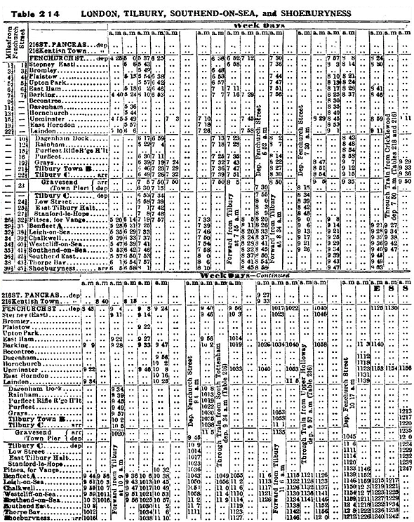
 Services initially ran from Fenchurch Street and Bishopsgate stations over existing lines to Stratford and Forest Gate Junction. The line was quickly extended reaching Hornden in late 1854, Leigh-on-Sea on 1 July 1855 and finally Southend on 1 March 1856.
 In 1912 the Midland Railway took over the London Tilbury & Southend Railway and in 1923 The Midland Railway was incorporated into the London Midland & Scottish Railway Company. By about 1933 there was a need for more powerful engines and in 1934 came 36 3-cylinder 2-6-4Ts, numbered 2500 - 2536, which replaced many older Tilbury Tanks.
 The London Plan Working Party Report of 1949 envisaged as its Route G the LTSR electrified and diverted away from Fenchurch Street to Bank and onward through the Waterloo & City line tunnels to Waterloo and its suburban lines. Of course, the Waterloo & City tunnels would have had to be bored out to main-line size for this proposal to succeed. The line was re-signalled between 1958 and 1961, starting in the Barking area in April 1958 and completed in August 1961 with the section between Purfleet and West Thurrock junction. Semaphore signals were replaced with 3- and 4-aspect searchlight signals.
 Electrification went ahead from 1961 to 1962 under British Railways and direct passenger services from Bromley, Plaistow, Upton Park, East Ham, Becontree, Dagenham and Hornchurch to Fenchurch Street were withdrawn. With the completion of electrification the remaining through steam services from St Pancras to LTSR destinations were removed. On 6 November 1961 the first electric train entered service and the last steam trains ran in June 1962.

 Home Page