
Station Name: TOWNELEY[Source: Alan Young]
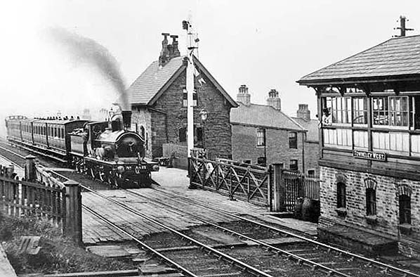 Towneley station looking north c1905. The train is at the up (Halifax-bound) platform. The main station building is on the right, constructed of sandstone and including booking and waiting facilities and accommodation for the stationmaster. On the right is the Saxby & Farmer signal box constructed in 1878 and replacing an earlier box on the same side of the tracks, immediately beyond the level crossing. It is ‘Towneley West’, there being another box further south-east known as Towneley Colliery Sidings. The locomotive is either a Barton Wright or an Aspinall 4-4-0. The two were difficult to tell apart but the Aspinall possessed a slightly higher cab roof and this appears to apply here. Only part of its number is visible, the final two digits '15', so confirmation is difficult but it might be Aspinall No.1115.
Photo from John Mann collection 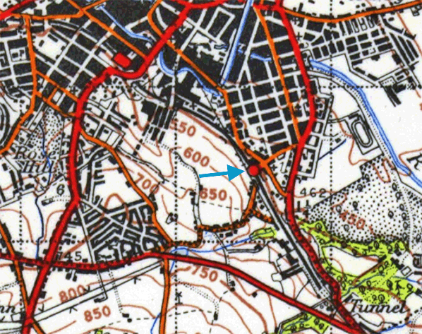 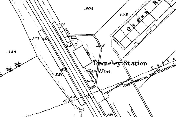
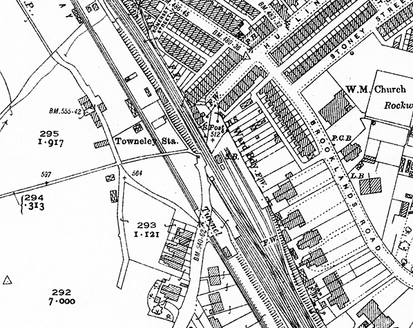
1851 1: 1,056 OS Town Plan. Its setting is unmistakably rural in 1851, but Towneley station is close enough to Burnley - a town rapidly expanding with its coal mining and weaving industries – to justify the production of this very large scale map. The railway and station opened in 1849. The line is double track, and the station has two facing platforms with the station building and signal box on the up (north-east) platform adjacent to the level crossing. No building is shown on the down platform. Just beyond the extent of this map extract, the goods and mineral facilities (Towneley Colliery sidings) to the south-east are extensive, with three sidings and loading docks on the up side of the line and a further siding on the down side.
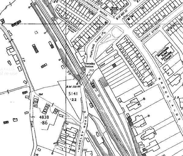
1893 1: 2,500 OS map. A building has appeared on the down platform of Towneley station since the earlier survey. The goods facilities have expanded, notably on the down side. The original signal box has been replaced with one south-east of the level crossing. A tramway runs almost parallel with the railway, passing behind the down platform; it connects Boggart Bridge Pit and Towneley Colliery with a coal depot beside the Leeds & Liverpool Canal. The suburb of Burnley Wood has spread as far as the railway, with a marked contrast between the densely-packed terrace housing east and north-east of the station and the middle-class detached and semidetached houses and a short terrace, with gardens. At this time OS policy was to include the landscape within private gardens; comparison with the 1961 map will show that this practice has ceased, producing a more clinical and less appealing effect.
 1931 1:2,500 OS Map. In 1931 Towneley station has undergone no significant change since the map of 1893, but there has been a small amount of residential development: terraced houses to the east, with what look like allotments adjacent to the sidings, and some semidetached houses to the south. The tramway from Boggart Pit and Towneley Colliery is still in place with a tunnel named where it passes beneath the road south of the station.
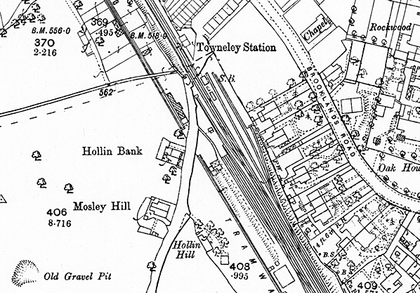
 1961 1: 2,500 map. Towneley station closed to passengers in 1952 and goods in 1960. It is still named on the map, suggesting that it was functioning when the survey was carried out. Both of the platforms and the station building are shown, but the shelter on the down platform has been removed. South-east of the level crossing, the several sidings on the down side have been dismantled, but the earthworks on which they were laid can still be seen. The up-side goods facilities are still in place. The tramway from the Boggart Bridge Pit and Towneley Colliery, both now closed, has been dismantled.
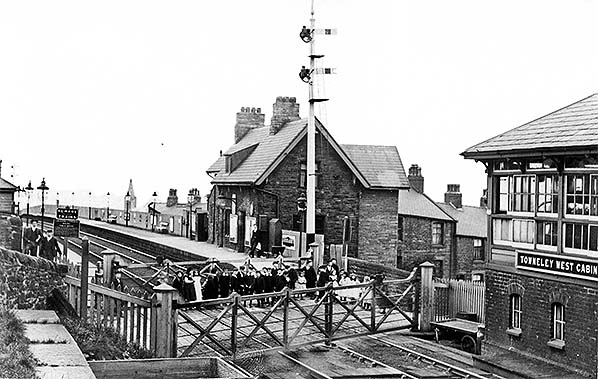
Towneley station looking north c1905, with what might be a Sunday School excursion party standing on the gated level crossing, kitted out in their best clothes for the special occasion. The station building on the up (Halifax-bound) platform is shown clearly; a modest, but attractive, sandstone structure serving as the stationmaster’s house as well as containing the booking and waiting facilities. The hipped-roofed shelter on the down platform is visible, far left. Gas lamps with large glass bowls can be seen on both platforms. On the right is the Saxby & Farmer signal box constructed in 1878 and replacing an earlier box on the same side of the tracks, immediately beyond the level crossing. The LYR has used ‘Cabin’ rather than ‘Signal Box’ on its nameplate; quite what the distinction was between a cabin and a signal box is unclear. It is ‘Towneley West’, there being another box further south-east known as Towneley Colliery Sidings.
Copyright photo from John Alsop collection 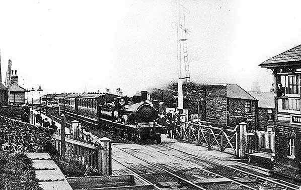
A five-coach up passenger train is calling at Towneley station prior to 1906. The main building on the up platform is partially obscured by steam from the locomotive, but the hipped-roofed, timber waiting shed on the down platform is visible. Towneley West Signal Cabin is seen far right. The locomotive is either a Barton Wright or an Aspinall 4-4-0. The two were difficult to tell apart but the Aspinall possessed a slightly higher cab roof and this seems to apply here. Unfortunately its number is invisible.
Copyright photo from John Alsop collection 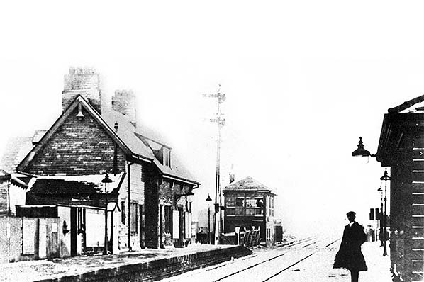
Towneley station looking south-east from the down platform c1910. The stone two-storey station house and offices are on the up platform with the Saxby & Farmer signal box beyond the level crossing. Part of the waiting shelter on the down platform is seen in the foreground.
Photo from B C Lane collection 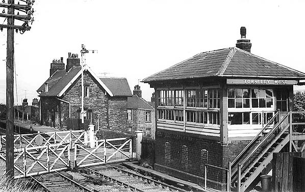
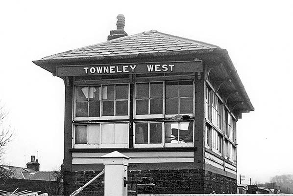
Towneley station looking north in 1959, seven years since it closed to passengers. The station building and the up (Halifax-bound) platform are visible. The signal box nameplate reads ‘Towneley West’ although its neighbour to the south-east, Towneley Colliery Sidings had closed in 1951.
Photo from John Mann collkection 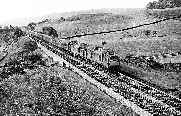 On 25 June 1966 a Sheffield to Blackpool extra hauled by D6828 and D6830 is
approaching Towneley station. Photo by Ian G Holt 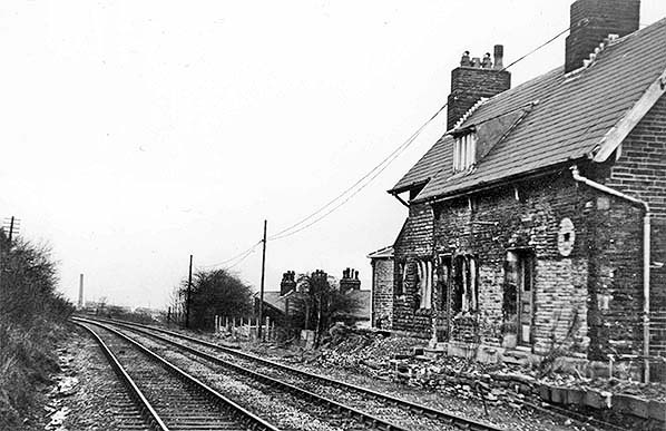
Looking north at Towneley station in February 1971. The station has been closed to passengers for two decades. The down (Burnley-bound) platform formerly stood to the left of the tracks, and nothing remains of it. Fragments of the up platform can be seen on the opposite side of the tracks in front of the extant main station building, which is in residential use. The imprint of the station clock can be seen as a pale patch on the soot-blackened structure. The station’s goods facilities closed in 1960.
Photo
by John Mann
The signal box at the disused Towneley station, looking south from the level crossing in February 1971. The box is a Saxby & Farmer Type 9 design constructed by the Lancashire & Yorkshire Railway in 1878. It is ‘Towneley West’, as distinct from Towneley Colliery Sidings, a neighbouring box
that closed in 1951. Photo
by John Mann
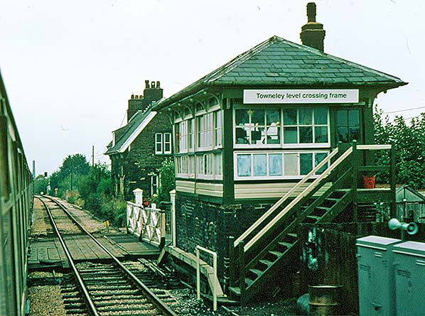
The disused Towneley station’s main building and signal box looking north from a passing Stevenage to Blackpool North excursion train on 8 October 1977. The building is in residential use and its adjoining platform has been demolished. Since 1973 this section of line has been controlled by Preston Power Signal Box and the Towneley box has been relegated to ‘gate box’ status; it has been renamed ‘Towneley Level Crossing Frame’. In this process semaphore signals have given way to colour lights, as seen in the distance. Traditional crossing gates remain in place.
Photo by Alan Young 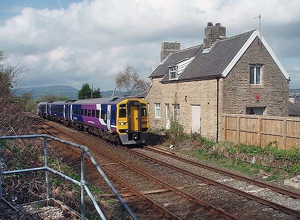
Northern Rail Class 158/0 BREL 'Express Sprinter' No. 158756 passes Townley station in April 2011 as it tackles the climb to Copy Pit summit with a Northern service to York.
Photo by Mark Bartlett 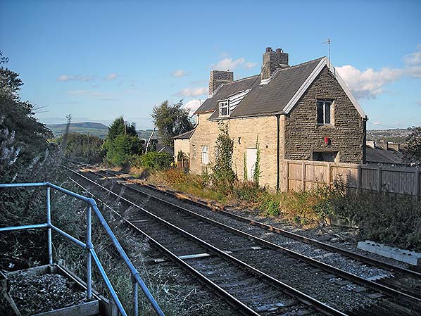 Looking north from the level crossing at the former Towneley station building on the up side of the Copy Pit route in September 2011. The building is in residential use. Pendle Hill can be seen in the distance.
Photo by Alan Young 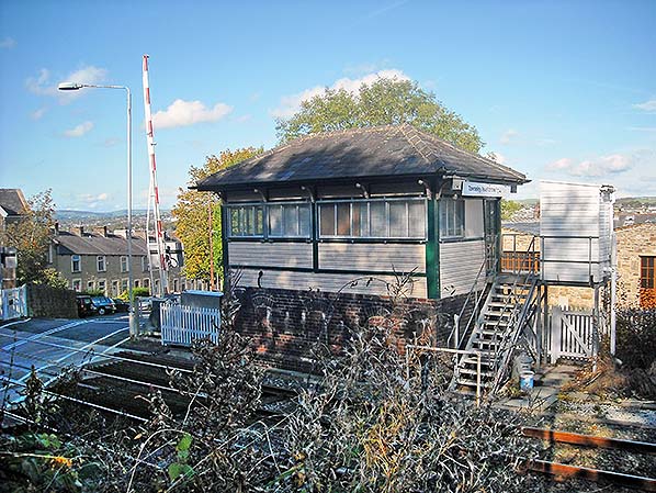
Towneley Level Crossing signal box in September 2011, now with ‘Frame’ erased
from the box nameplate. Photo
by Alan Young
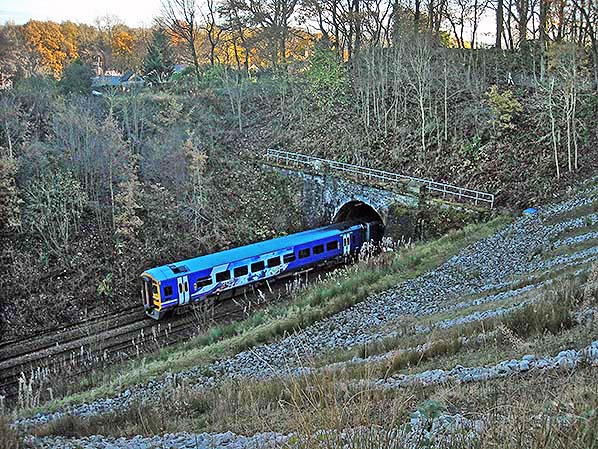
On 24 November 2016 a Class 158 DMU plunges into the 398yd Towneley Tunnel. This is the 09.11 from Blackpool North to Leeds. The north-west portal of the tunnel is seen here, looking north-east. Recent drainage and stabilisation work on the cutting will be noted.
Photo by Alan Young
|
 The station possessed two facing platforms immediately north-west of a level crossing, and the main building was on the up (north-east, or Todmorden-bound) platform. It was of two storeys, constructed of small sandstone blocks laid in courses, under a pitched slate roof, broken by a dormer. The north-western part of the building was set back a little way from the platform, followed by a small single-storey wing. A two-storey extension was on the side away from the platform. This building, although by no means an architectural gem, was superior to the others on the Copy Pit route; the design was presumably thought to be acceptable to the Towneley family. A timber waiting shed with a hipped roof was built on the down platform sometime after the station opened. The signal box was initially on the up platform, adjacent to the level crossing, but it was replaced in 1878 with a box south-east of the crossing, again on the up side of the tracks. The new box was a Saxby & Farmer Type 9, originally containing a 26-lever S&F frame, but fitted with a new 24-level LYR frame at a later date. The box was originally known as Towneley West, but it was renamed Towneley Station following the closure of the nearby Towneley Colliery Sidings box (see below) in December 1951.
 A generously-sized goods and mineral facility, controlled from 1878 by Towneley Colliery Sidings signal box, stretched south-east of the passenger station, on the opposite side of the level crossing. The OS plan of the station in its first decade shows three sidings and loading docks on the up side of the line and a further siding on the down side. There was clearly optimism that Burnley’s rapid growth as a coal mining and cotton weaving town in the mid nineteenth century would continue, requiring ample goods facilities.
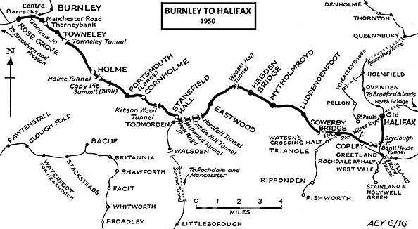
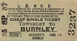 Towneley station’s value to passengers was probably limited by the locations of Manchester Road and Rose Grove, to which trains ran directly, neither of which was convenient for the centre of Burnley. Trams and, later, motor buses on Todmorden Road operated to the centre from close to Towneley station. On 4 August 1952 the station closed to passengers, although the goods yard continued in use until 7 March 1960. The waiting shed on the down platform had been dismantled by 1961, but the platforms remained in place at this time. The up sidings were proposed for abolition on a plan dated 1 April 1959, and they were recovered soon afterwards. On 7 October 1973 the station signal box was reduced to gate box status (and renamed Towneley Level Crossing Frame) when Preston Power Signal Box took control of the this section of line. The frame was dismantled and superseded by an IFS (Individual Function Switch) panel in 1978. By 1977 both platforms had gone. The station building remains in residential use, accompanied by the signal box (‘Towneley Level Crossing’). Sometime between 1977 and 2011 the traditional crossing gates were replaced with lifting barriers.
 Home Page