
Station Name: EASTWOOD (Yorks)[Source: Alan Young]
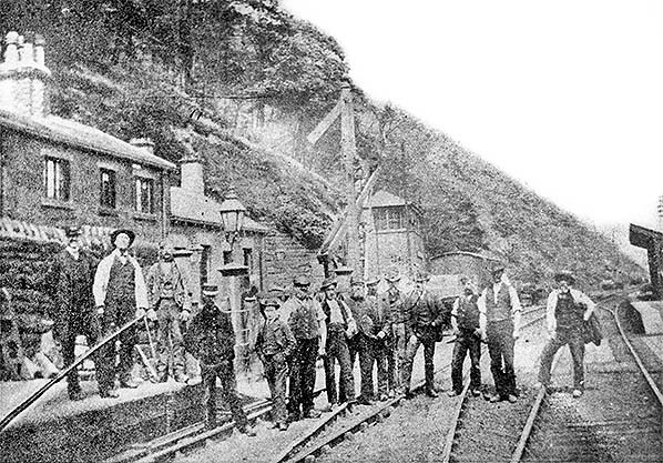 Eastwood (Yorks) station in the 1880s, looking north-east. A local history website describes the men on the platform and the tracks as the ‘station gang’; there appear to be smartly dressed station staff as well as permanent way men in their work clothes. The photographer seems oblivious to the fact that a train is signalled. The stationmaster’s house and office range is to the left, backing onto the rock cutting and complementing the severely utilitarian architecture of local houses. Beyond the level crossing are the signal box, also on a site excavated from the steep hillside, and the up (Manchester-bound) platform with its timber waiting shed.
Photo from Jim Lake and from Pennine Horizons Digital Archive collections 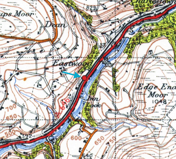 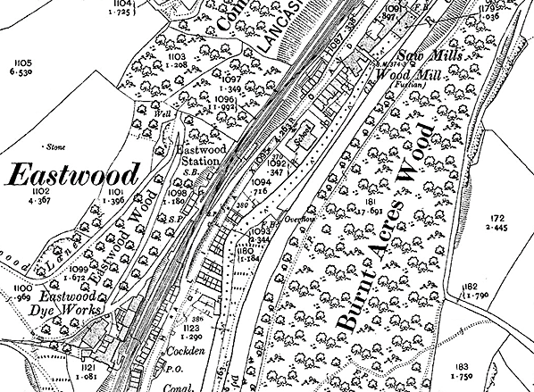
1907 1: 2,500 OS map. The River Calder, the Rochdale Canal, Halifax Road and the railway jostle for space in the deep, narrow valley at Eastwood between Todmorden and Hebden Bridge. Industrial housing, some of it back-to-back, is also squeezed in, together with a school, an independent chapel, a dye works and a moleskin finishing mill. Eastwood station is perched on a valley-side ledge; its main building (west of the tracks) backs directly onto a sheer rock face, and the platforms are staggered either side of the level crossing on Eastwood Lane, a narrow track that zigzags its way up the slope, serving the dye works as it heads for the moors. Despite the constraints of the site, space has been found for goods sidings north-east of the station, and a loop is installed opposite the
Leeds-bound platform. Click here for a larger version. 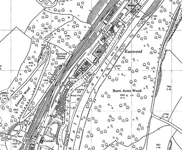
1963 1: 2,500 map. The River Calder, the Rochdale Canal, Halifax Road and the railway jostle for space in the deep, narrow valley at Eastwood between Todmorden and Hebden Bridge. Industrial housing, some of it back-to-back, and a textile mill are also squeezed in. Eastwood station, closed to passengers since 1951 but still handling goods traffic, is perched on a valley-side ledge; its main building (west of the tracks and with its internal divisions shown) backs directly onto a sheer rock face, and the adjacent signal box (SB) is located in a cleft hewn in the steep valley side. The platforms are staggered either side of the level crossing on Eastwood Lane, a narrow track that zigzags its way up the slope, formerly serving dye works as it heads for the moors. Despite the constraints of the site, space has been found for goods sidings north-east of the station, and a loop is installed opposite the Leeds-bound platform. Click here for a larger version
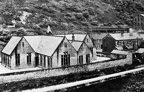 This is thought to be an early twentieth century view of Eastwood (Yorks) with the Council School in the foreground and the rear of the station’s up platform and running-in nameboard to the left, in the distance.
Photo from Maurice Hartley collection 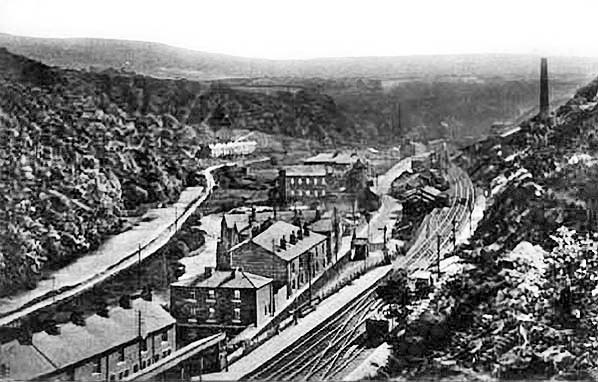 Looking south-west across Eastwood (Yorks) in the early twentieth century. The railway is at the foot of the slope from which the photograph is taken; the up (Manchester-bound) platform with its timber shelter is at the bottom of the picture, whilst the down platform is beyond the level crossing and on the opposite side of the tracks. The roof and chimneystacks of the station building are visible, set back into the steep slope at the near end of the down platform. To the left of the railway are the Hebden Bridge to Todmorden road, the River Calder and the Rochdale Canal, all competing for space in the Looking south-west across Eastwood (Yorks) in the early twentieth century. The railway is at the foot of the slope from which the photograph is taken; the up (Manchester-bound) platform with its timber shelter is at the bottom of the picture, whilst the down platform is beyond the level crossing and on the opposite side of the tracks. The roof and chimneystacks of the station building are visible, set back into the steep slope at the near end of the down platform. To the left of the railway are the Hebden Bridge to Todmorden road, the River Calder and the Rochdale Canal, all competing for space in thedeep, narrow valley. Photo from John Mann collection 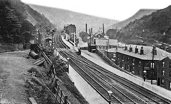 Eastwood (Yorks) station looking north-east c1910. The constricted site is clearly seen. The down (Leeds-bound) platform is closest to the camera, with a series of gas lamp standards and a small pitched-roof shelter partly obscured by a bush. On the same side of the track, beyond the level crossing, is the main station building set back into the steep cutting wall; a glazed lean-to can be seen on its gable end. The signal box is beyond the station building. The up platform is also on the far side of the crossing, its only passenger accommodation being the pent-roof timber waiting shed. The up loop is seen parallel to the main up and down lines (right) and the goods facilities are on the far side of the level crossing. This view shows the sloping station approach roads which meet at the small pitched-roof building (coal office?) with a chimneystack. The industrial character of the valley is apparent with Wood Mill beyond the up platform; the OS plan of 1894 identifies its role as ‘moleskin finishing’, but by 1907 it produced fustian, the heavy-duty cotton cloth for which nearby Hebden Bridge was celebrated. Eastwood (Yorks) station looking north-east c1910. The constricted site is clearly seen. The down (Leeds-bound) platform is closest to the camera, with a series of gas lamp standards and a small pitched-roof shelter partly obscured by a bush. On the same side of the track, beyond the level crossing, is the main station building set back into the steep cutting wall; a glazed lean-to can be seen on its gable end. The signal box is beyond the station building. The up platform is also on the far side of the crossing, its only passenger accommodation being the pent-roof timber waiting shed. The up loop is seen parallel to the main up and down lines (right) and the goods facilities are on the far side of the level crossing. This view shows the sloping station approach roads which meet at the small pitched-roof building (coal office?) with a chimneystack. The industrial character of the valley is apparent with Wood Mill beyond the up platform; the OS plan of 1894 identifies its role as ‘moleskin finishing’, but by 1907 it produced fustian, the heavy-duty cotton cloth for which nearby Hebden Bridge was celebrated.Photo from John Mann and from Pennine Horizons Digital Archive collections 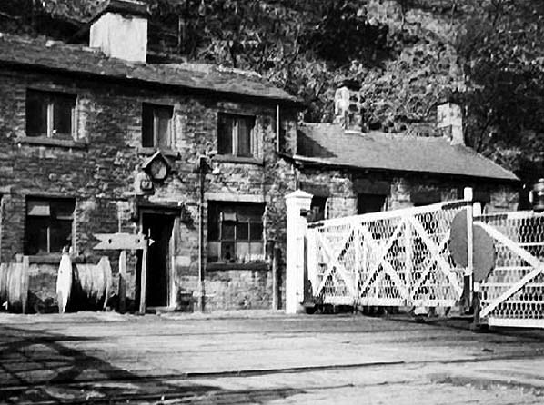
Eastwood (Yorks), looking north-west over the level crossing c1952, apparently just after the closure of the station to passengers. The two-storey stationmaster’s house, possibly derelict, is to the left; it also contained the booking office, to the right of the main doorway. Whereas most of the window is glazed one lower section is a ‘ticket window’, suggesting that passengers did not need to enter the booking office to buy their tickets. A single-storey office and waiting room range is to the right. The building is of coursed sandstone and its design lacks adornment. The clock, sheltered by a tiny gable, will be noted. The hill slope had to be excavated to provide the site for the building.
Photo from Alice Longstaff collection 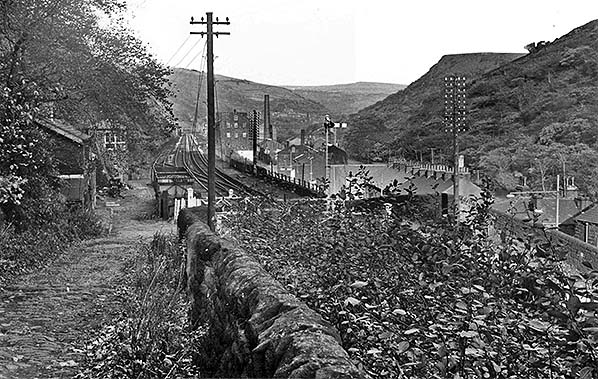
Looking down Eastwood Lane towards Eastwood (Yorks) station in 1963. The station closed to passengers in 1951 but its goods facilities are still open at the time of this photograph. A siding on the down (Leeds-bound) side of the tracks holds a couple of coal trucks, and in the distance a siding serving the coal depot can be seen diverging from the up line. Far left, the station building and signal box are seen pressed against the cutting wall. The disused up passenger platform is on the right, beyond the level crossing, notable for being only slightly above rail height; a series of lamp standards remains on the platform but the waiting shed has been removed. The down platform is out of sight below the wall and vegetation to the right.
Photo from John Mann and from Pennine Horizons Digital Archive collections 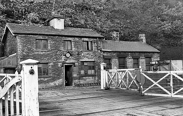 Eastwood (Yorks) station in August 1963, looking north-west over the level crossing. The derelict two-storey section is to the left, formerly comprising the stationmaster’s accommodation and the booking office - as indicated on the lintel of the large window - with the single-storey office and waiting range to the right. The building is of coursed sandstone and its design lacks adornment. A lean-to porch adjoins the gable end, far left. The clock is sheltered by a tiny gable. The hill slope had to be excavated to provide the site for the building. Although closed to passengers since 1951 the station still handles goods traffic, and a coal wagon can be seen on the siding, far right.
Photo from John Mann and from Pennine Horizons Digital Archive collections 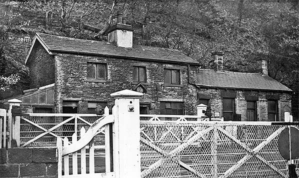
Eastwood (Yorks) station in August 1963, looking north-west over the level crossing. The derelict two-storey stationmaster’s house and booking office is to the left, with the single-storey office and waiting room range to the right. The building is of coursed sandstone and its design lacks adornment. A lean-to porch adjoins the gable end, far left. The hill slope had to be excavated to provide the
site for the building. Photo from John Mann collection Click here for Eastwood Station Gallery 2:
|
 The main building was placed just beyond the north-east of the down (Leeds-bound) platform and included accommodation for the stationmaster and the booking office. It was a particularly plain two-storey structure that could have been plucked from any of the settlements in upper Calderdale, built of coursed, locally quarried thin sandstone blocks under a pitched slate roof. The window openings were unadorned, but the central doorway was sheltered by an angular hood-mould. The relatively short upstairs windows gave the building rather a pinched appearance, and this was emphasised by the single-storey office and waiting room range to the north-east, also of sandstone, whose roof-line was almost as high as its two-storeyed neighbour; the window and door openings were much taller on the single-storey section, again contributing to the unbalanced composition. Altogether the station building, fitting snugly into a sheer rock face, was ugly but fascinating. The signal box stood several yards north-east of the station building, set into a stone-lined recess in the cutting.
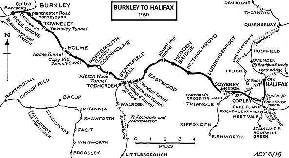
 The A646 road runs parallel and close to the railway between Hebden Bridge and Todmorden, and by the 1930s frequent motor buses between these towns ran through Eastwood, gradually winning passengers from the railway. Eastwood survived into the British Railways (BR) era, which commenced in January 1948, when the station was allocated to the London Midland (LM) Region. In April 1950 a major revision of BR regions transferred a large portion of the West Riding lines in the Leeds, Bradford and Halifax area from the LM to the North Eastern (NE) Region; Eastwood remained in the LM but the boundary with the NE was only a short distance north-east of the station.
 Home Page