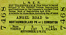
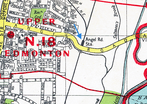
Notes: Angel Road was called Watery Lane in 1557 and Marsh Lane in the late 16th century, taking its present name in the 1870s from the inn standing at the corner of Fore Street. The opening of the station in 1840 was too early to bring suburbanisation to the vicinity as Londoners were not at that time prepared to countenance living so far from their place of work, partly because fares were high and services slow.
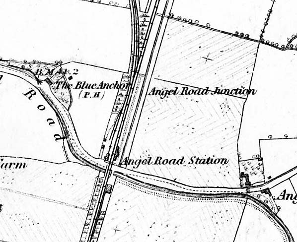
 The station was initially called Edmonton and the earliest available large scale map (1882 but surveyed 1863) shows the station located to the north Angel Road level crossing. There is a platform on the up side with a range of buildings. It is assumed there was a down platform although this isn't clear from the map. The company board minutes for 7 March 1851 mention 'siding from Enfield Line to left of up line with additional platform to be immediately constructed'. It is unclear of this refers to an additional platform for the main line or just for the Enfield line. Another board minute from 6 June 1851 implies that trains joined/split at Water Lane. A further board minute from 20 August 1853 mentions "covered way to be erected to new down platform at Water Lane, for about six carriage lengths" This probably refers to a platform canopy. In 1854 the station master, a Mr. Pearson was dismissed for inefficiency. The station was initially called Edmonton and the earliest available large scale map (1882 but surveyed 1863) shows the station located to the north Angel Road level crossing. There is a platform on the up side with a range of buildings. It is assumed there was a down platform although this isn't clear from the map. The company board minutes for 7 March 1851 mention 'siding from Enfield Line to left of up line with additional platform to be immediately constructed'. It is unclear of this refers to an additional platform for the main line or just for the Enfield line. Another board minute from 6 June 1851 implies that trains joined/split at Water Lane. A further board minute from 20 August 1853 mentions "covered way to be erected to new down platform at Water Lane, for about six carriage lengths" This probably refers to a platform canopy. In 1854 the station master, a Mr. Pearson was dismissed for inefficiency.
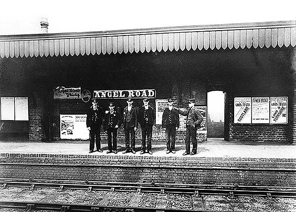
There is a small goods yard with two or three sidings on the down side opposite the station buildings. To the south of the station there is a goods shed on the up side with a siding passing through it. The goods shed was erected in 1852 having been moved from Wickham Bishops. Further south the Tottenham & Edmonton Gas Works which opened in 1847 is alongside the line. At this time there were no sidings running into the gas works but there is a siding alongside the main line. At this time the station didn't have a signal box. The station master in 1850 was a Mr. Couch. The Railway Tavern pub opened in 1841 to the west of the station on Angel Road. The first licencee was William Bodinelle. In 1844 the Tavern was owned by the Busk family who also owned The Stag & Hounds. The Tavern was later renamed The Blue Anchor.
With the opening of the Enfield Town branch on 1.3.1849 the station became a junction and was renamed Water Lane (and sometimes Water Lane Junction). The final change of name occurred on 1 January 1864 when the station became Angel Road (and sometimes Angel Road Junction).
 The first signal box was provided 1.3.1849 with the opening of the Enfield Town branch, it was a signal hut called Water Lane. It was originally sited at the junction but was later relocated to the south end of the down platform. Modern signalling was installed by Stevens and Sons in 1873 and the signal hut was abolished to be replaced by a new box. This box was replaced in 1880 and lasted until May 1909. It initially had 34 levers, extended to 38 levers c1900 and extended again to 40 levers in 1908. The first signal box was provided 1.3.1849 with the opening of the Enfield Town branch, it was a signal hut called Water Lane. It was originally sited at the junction but was later relocated to the south end of the down platform. Modern signalling was installed by Stevens and Sons in 1873 and the signal hut was abolished to be replaced by a new box. This box was replaced in 1880 and lasted until May 1909. It initially had 34 levers, extended to 38 levers c1900 and extended again to 40 levers in 1908.
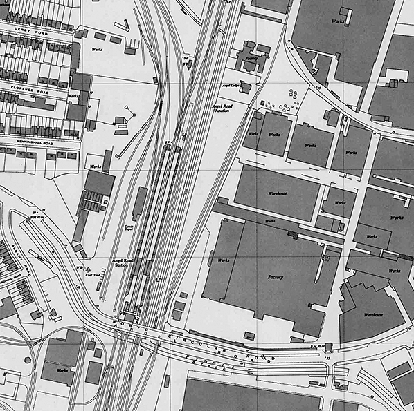
Angel Road Junction box in the V of the junction opened in May 1909 after abolition of the level crossing. It was a McKenzie and Holland box with a 45 lever frame. Angel Road South Box opened 11.1910 and was abolished 1.1.1926 with one additional lever being added to the Junction Box. The Junction Box survived until 9.3.1969
Angel Road itself was liable to extensive flooding by Pymmes Brook and various minutes of the ECR board record instances of flood damage and new drainage in the Lea Valley. The problem wasn't resolved until the whole of the Lea Valley line was provided with wide drain channels on both sides. However, the railway did encourage industrial growth on the highly affordable marshland between the station and the River Lea, a process that accelerated at the beginning of the 20th century.
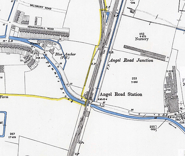
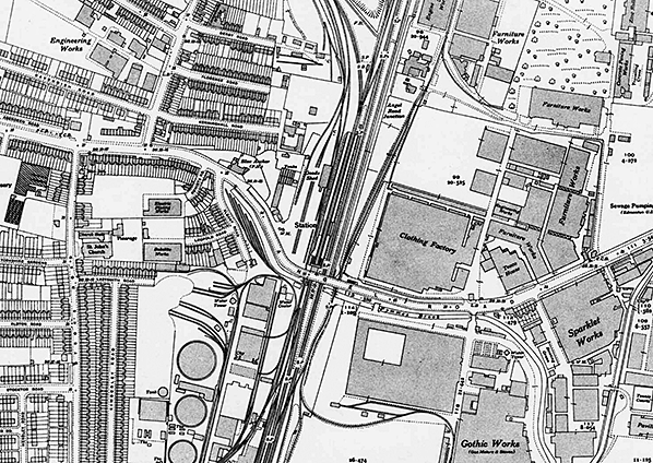
The 1896 OS map reproduced below clearly shows two platforms spanned by a footbridge immediately north of the level crossing; the up platform is a little longer than the down. Buildings and platform canopies are shown on both sides with the buildings on the down side incorporating the stationmaster's house. There are two sidings on the down side running behind the down platform. To the south of the station the gas works now has a small network of sidings accessed from two wagon turntables on the gas works siding. By this time there was some residential development to the west of the stations with a number of new roads being laid out.
In 1897 as part of a scheme the widen the railway south of Broxbourne authorisation was given for the provision of two goods loops running behind the up platform. These ran as far as Picketts Lock Junction a distance of 1¼ miles.
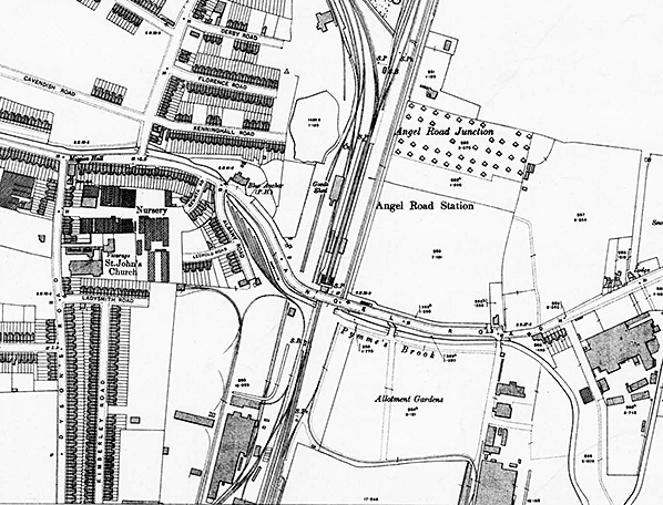
 In 1909 the level crossing was replaced by a bridge and all the buildings, including the station house were demolished and replaced by brick waiting rooms and toilets with canopies on both platforms. The building on the down side was longer than the up side building. By this time, terraced housing was spreading outwards from the western part of Angel Road, helped by improvements in bus services and later by the introduction of trams. A new entrance building with a pitched roof was provided on the north side of the bridge with steps down to the two platforms. The building had a bus lay-by but the station had no parking facilities. A third siding has been added on the down side with one siding running through a new larger goods shed. A 3-ton capacity crane was provided in the yard in 1896. To the south of the station, the original goods shed has been demolished. There is a new siding on the up side running up to Angel Road and from this another siding curves to the east running into the Gothic Works (making gas metres and stoves). The gas works on the down side now has a substantial network of internal sidings. The Railway Clearing House Handbook for 1904 lists private sidings for Glover & Mains, London Fireproof Wall Co, Martin & Co, Staceys and the Tottenham & Edmonton Gas Co. In 1909 the level crossing was replaced by a bridge and all the buildings, including the station house were demolished and replaced by brick waiting rooms and toilets with canopies on both platforms. The building on the down side was longer than the up side building. By this time, terraced housing was spreading outwards from the western part of Angel Road, helped by improvements in bus services and later by the introduction of trams. A new entrance building with a pitched roof was provided on the north side of the bridge with steps down to the two platforms. The building had a bus lay-by but the station had no parking facilities. A third siding has been added on the down side with one siding running through a new larger goods shed. A 3-ton capacity crane was provided in the yard in 1896. To the south of the station, the original goods shed has been demolished. There is a new siding on the up side running up to Angel Road and from this another siding curves to the east running into the Gothic Works (making gas metres and stoves). The gas works on the down side now has a substantial network of internal sidings. The Railway Clearing House Handbook for 1904 lists private sidings for Glover & Mains, London Fireproof Wall Co, Martin & Co, Staceys and the Tottenham & Edmonton Gas Co.
In 1927 Angel Road became part of the North Circular Road, bringing still more factories to the area.
By 1937 little had changed at the station apart from the additions for a fourth siding running alongside the goods shed on the east side. The two goods loops which were authorised in 1897 have been laid behind the up platform. The Blue Anchor pub to the west of the station (formerly The Railway Tavern) closed in 1937. The pub was destroyed during WW2 when it was damaged by blast from a V1 flying bomb on 22.7.1944 and the pub licence was discontinued on 18.10.1944.
The 1956 Railway Clearing House Handbook of Stations lists private sidings for Dusmo Ltd, Eastern Gas Board, Eley Brothers, Glover & Main, Thomas Glover & Co, R Main Ltd, Ready Mixed Concrete Ltd and Simplex Concrete Piles Ltd. The original yard crane had, by this time, been replaced by an 8 ton capacity crane. Edmonton council began to put up housing in the area in the 1930s and chose Angel Road as a prime zone for the building of tower blocks in the early 1960s.
In 1975 work to rebuild and realign the North Circular Road viaduct was completed. This included relocating the station entrance to the south side of Angel Road. This work was probably completed prior to work starting on the road to avoid disruption to passengers. The original building was retained but reversed with the new entrance being at what was the rear of the building. The booking office was by 1987 rebuilt in a simpler form similar to that at Lea Bridge. At some time during this period the platform buildings were demolished and replaced by two bus shelters. BR Eastern Region blue signage was also removed and replaced by black on white corporate identity signs. The new entrance was to be short lived. The building and steps down to the platforms were demolished and a new entrance was provided on the north side of Conduit Lane. There was no building with steps leading down to a footpath running south along the west side of the line. The footpath led to the station entrance at the north end of the down platform. A new footbridge was provided so that passengers could reach the up platform.
The goods shed and a 1-ton crane internal survived until the early 1980s surrounded by scrap metal. A scrap yard still occupies the goods yard site today.
 Around 2007 Enfield council began to formulate regeneration plans for the area to the south of Angel Road then referred to as Central Leeside. This had previously been the site of the Tottenham & District Gas Company on the wast side of the railway and The Gothic Works (later part of Thorn Electrical Industries) on the east side. Over the next few years the plans became ever more ambitious until, by 2015, a total transformation was envisaged, with over 200 acres of homes, parks and commercial premises comprising a new neighbourhood (almost a whole new town) to be called Meridian Water. As part of the new development, a new station to replace Angel Road has now been provided on the Lee Valley line with construction beginning in November 2017. In August 2018, the Department for Transport began a consultation on the proposal to close Angel Road. On 24th January 2019, the DfT announced that Angel Road will officially close on 19 May 2019, the same day Meridian Water station opens. The closing date was subsequently delayed twice because Meridian Water was not ready. Around 2007 Enfield council began to formulate regeneration plans for the area to the south of Angel Road then referred to as Central Leeside. This had previously been the site of the Tottenham & District Gas Company on the wast side of the railway and The Gothic Works (later part of Thorn Electrical Industries) on the east side. Over the next few years the plans became ever more ambitious until, by 2015, a total transformation was envisaged, with over 200 acres of homes, parks and commercial premises comprising a new neighbourhood (almost a whole new town) to be called Meridian Water. As part of the new development, a new station to replace Angel Road has now been provided on the Lee Valley line with construction beginning in November 2017. In August 2018, the Department for Transport began a consultation on the proposal to close Angel Road. On 24th January 2019, the DfT announced that Angel Road will officially close on 19 May 2019, the same day Meridian Water station opens. The closing date was subsequently delayed twice because Meridian Water was not ready.
Angel Road station finally closed on 31 May 2019 with Meridian Water opening on 3 June 2019. At the time of closure, Angel Road was the quietest station in London with just 27,743 users during 2015/16. It is expected 4 million people will use the new station annually. There was no ceremony and apart from a number of enthusiasts it was no different to any other day.
Meridian Water station is 630 yards south of Angel Road; it has three platforms with a fourth built without track. The platforms are numbered 2-4 and platform 1 is available for use if required in the future. The station could become a stop on the proposed Crossrail 2 north-to-south line. As part of the London Railway Upgrade Plan, Network Rail are building 5.5 Km of new track which will allow an extra two trains per hour (peak) to run between Stratford and the new Meridian Water station, reduce congestion for passengers and support regeneration across the Upper Lee Valley area.
Click here for ECR and GER board minutes that relate to Water Lane/Angel Road. These include details of new works including signalling and station buildings.
BRIEF HISTORY OF THE BISHOPS STORTFORD & ENFIELD TOWN BRANCHES
When the Stockton and Darlington Railway was opened in 1825, great enthusiasm for railway transport was generated. A number of schemes were put forward for connecting London and York. A public meeting was held at Cambridge Town Hall on 23 January 23 1836, at which it was decided to support a route surveyed by James Walker. A Bill for a Northern & Eastern Railway was prepared; it was to run from London to Cambridge, with a branch from a little south of Cambridge to Newmarket, Norwich and Yarmouth. The Bill was passed, but the route was cut back to run from London to Cambridge only; it received the Royal Assent on 4 July 1836. Authorised share capital was £1,200,000. Although the construction cost was large, the Company was confident of a 16% return.
 The Northern and Eastern Railway was to have its London terminus at Islington. The topography was such that this would have required tunnelling to reach it, and it was realised that this was an expensive proposition. An approach was made to the Commercial Railway (later the London and Blackwall Railway) with a view to using its final approach to London. This was unsuccessful, so the Eastern Counties Railway was contacted, with a view to using the ECR Shoreditch terminus. This was agreed to, and Parliament ratified the arrangement, so the Northern and Eastern Railway's planned line was rerouted from Tottenham to join the ECR at Stratford. The ECR agreed to build a separate terminus at Shoreditch for the N&ER. The Northern and Eastern Railway was to have its London terminus at Islington. The topography was such that this would have required tunnelling to reach it, and it was realised that this was an expensive proposition. An approach was made to the Commercial Railway (later the London and Blackwall Railway) with a view to using its final approach to London. This was unsuccessful, so the Eastern Counties Railway was contacted, with a view to using the ECR Shoreditch terminus. This was agreed to, and Parliament ratified the arrangement, so the Northern and Eastern Railway's planned line was rerouted from Tottenham to join the ECR at Stratford. The ECR agreed to build a separate terminus at Shoreditch for the N&ER.
When the Eastern Counties Railway determined on its track gauge of 5 feet, the Northern and Eastern had to adopt the same gauge in order to use the approach tracks. The first section of the Eastern Counties Railway was opened on 18 June 1839, from a temporary terminus at Mile End to another temporary terminus at Romford.
At the end of 1837 a contract for construction of the line was awarded to David Macintosh. In March 1838 construction began, with Michael Borthwick as resident engineer. From the beginning, the N&ER was unable to raise the capital it needed for building its line. By May 1837 the contractor was in difficulties, and Robert Stephenson was appointed as Engineer in Chief, with Borthwick continuing as resident engineer. George Parker Bidder was appointed as the new contractor. Engineering contractors Grissell and Peto were approached late in 1837 about building the line as far as Bishop's Stortford. In March 1840 they started work between Stratford and Tottenham, and finally took over the work between Tottenham and Broxbourne from David McIntosh.
The Company obtained a further Act, which received the Royal Assent on 4 June 1840; the line from Bishop's Stortford to Cambridge was abandoned, and the share capital was reduced to £720,000.
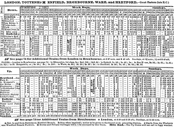
On 15 September 1840 the N&ER started operation between Stratford (ECR) and Broxbourne, a distance of about 15 miles. At first this was a single line; it was doubled in 1841. Trains ran through from Shoreditch; the ECR insisted that Shoreditch to Stratford journeys were exclusive to them. Five intermediate station opened with the line at Lea Bridge, Tottenham, Edmonton (later renamed Angel Road), Ponders End and Waltham.
The line was extended as far as Harlow on 9 August 1841; to Spelbrook (a temporary terminus) on 19 November 1841; and as far as Bishop’s Stortford on 16 May 1842.
A criticism of the route of the N&ER was that the line followed the valley of the River Lea, while nearly all of the settlements were on higher ground, and were some distance from the stations. Tottenham was used as the railhead for cattle being brought in to London; they walked from there to the London markets. In the second half of 1842 a dividend of 2% was paid.
The northernmost extent of the line was at Bishop's Stortford, opened before the end of 1843, when the Northern and Eastern Railway ceased to control its own network. However a special arrangement was made to receive excursion trains at Hockerill, a half mile or so north of Bishop's Stortford station.
 On 25 October 1843 an agreement facilitated by G P Bidder was reached by the ECR and N&ER, and from 1 January 1844 the entire N&ER system was leased to the ECR for 999 years; the arrangement was formally ratified by Parliament in May 1844. The ECR was to pay the N&ER 5 per cent annually on the £970,000 capital cost of building the line, and profits would be apportioned. The N&ER continued as an independent company, receiving the lease charges but not operating any railway; in fact it merged into the Great Eastern Railway in 1902. On 25 October 1843 an agreement facilitated by G P Bidder was reached by the ECR and N&ER, and from 1 January 1844 the entire N&ER system was leased to the ECR for 999 years; the arrangement was formally ratified by Parliament in May 1844. The ECR was to pay the N&ER 5 per cent annually on the £970,000 capital cost of building the line, and profits would be apportioned. The N&ER continued as an independent company, receiving the lease charges but not operating any railway; in fact it merged into the Great Eastern Railway in 1902.
At the same time as the discussion about the lease took place, the two companies agreed that their track gauge of 5 feet was a hindrance, and they decided to alter it to the standard gauge of 4ft 8 1⁄2in. The physical conversion was undertaken between 5 September 1844 and 7 October; it was achieved without interruption to the running of trains.
From the first day of 1844, the Northern and Eastern Railway was simply a financial shell company, receiving lease charges from the Eastern Counties Railway but not operating any railway. The N&ER network extended from Stratford to Bishop's Stortford and from Broxbourne to Hertford, and it became the stem of the important main line to Cambridge, finished by the Eastern Counties Railway. .
Enfield had been missed by the Northern and Eastern Railway line which had opened between Stratford and Broxbourne the nearest station was at Ponders End some two miles away. Local pressure led to the deposit of a bill before parliament in 1844 which failed. Two years later the Enfield and Edmonton Railway Bill was passed with arrangements for the Eastern Counties Railway to take over management of the project.
Work on the 3 mile 7 chain single line branch commenced in 1848 under the direction of contractor Thomas Earle (contractor). At Enfield Town the line terminated at a crossroads in central Enfield. This line branched off the Eastern Counties Railway (ECR) line at Edmonton (Angel Road). After the branch opened on 1 March 1849 the Edmonton station was renamed Water Lane and the new intermediate station on the branch was named Edmonton (This later became Lower Edmonton Low Level). The ECR at that point ran between London Shoreditch (Bishopsgate) and Bishops Stortford
The Eastern Counties Railway and certain other companies in East Anglia amalgamated to form the Great Eastern Railway in 1862. The GER adopted a policy of running frequent passenger services on the London suburban lines: in 1864 there were 29 departures for the Broxbourne line. Shoreditch station had been renamed Bishopsgate, but it was obviously inadequate for the Romford line traffic and the Broxbourne line, and the decision was taken to extend westwards: Liverpool Street station was opened in 1871.
Agitation for a more direct route to Liverpool Street led the GER to deposit the GER (Metropolitan Station & Railways) Act of 1864 before parliament. This proposed a double-track line between Hackney Downs to a junction just west of Edmonton. Due to the GER's financial difficulties in the late 1860s the line was not started until 1870.
 On 27 May 1872 the double-track line from Hackney Downs opened as far as Stoke Newington followed to Edmonton on 22 July and finally being linked to the existing branch at Edmonton Junction on 1 August. The line between the new junction and Enfield Town was also doubled providing a double-tracked route to Liverpool Street. This offered a quicker journey time into London Liverpool Street and this effectively became the Enfield Town branch. A new Edmondon station opened with the new line, it was called Lower Edmonton. On 27 May 1872 the double-track line from Hackney Downs opened as far as Stoke Newington followed to Edmonton on 22 July and finally being linked to the existing branch at Edmonton Junction on 1 August. The line between the new junction and Enfield Town was also doubled providing a double-tracked route to Liverpool Street. This offered a quicker journey time into London Liverpool Street and this effectively became the Enfield Town branch. A new Edmondon station opened with the new line, it was called Lower Edmonton.
The original route thence declined in importance from this date and was generally used as a diversionary route with a limited passenger service. Lower Edmonton was renamed Lower Edmonton High Level on 1.7.1883 and Edmonton became Lower Edmonton Low Level. In 1891 the Churchbury Loop was opened, from Bury Street Junction, to Cheshunt. The area was undeveloped and the sparse train service failed to encourage residential travel. It closed to ordinary passenger trains in 1909.The Stratford to Copper Mill Junction (Tottenham Hale) section was retained, and became a key link for goods traffic approaching Temple Mills Yard
The passenger use of the line intensified in the twentieth century, particular for residential travel as people became accustomed to travelling longer distances in order to live in more rural surroundings. Cambridge too became increasingly significant as a regional centre, attracting express passenger trains over the route. Goods and mineral traffic too remained dominant, although declining steeply after 1955.
Organisationally the Northern and Eastern Railway Company was absorbed into the Great Eastern Railway in 1902; the GER was a constituent of the new London and North Eastern Railway in 1923 (as part of the 'grouping' of the railways) and in 1948 the LNER in turn was nationalised.
In 1939 Edmonton Low Level station closed to passengers although the line remained open for goods and occasional diversions. On the newer part of the branch services were reduced as a wartime economy measure. On 7 December 1964 the line through Lower Edmonton (Low Level) station was closed with track being lifted in 1965.
The Lea Valley line between Copper Mill Junction and Cheshunt was electrified at 25 kV in May 1969. Prior to the completion of electrification in 1969, passenger services between Cheshunt and London through Angel Road were normally operated by Class 125 diesel multiple units (which had been purpose-built for the line in 1958).
 When sectorisation was introduced in 1986, the station was served by Network SouthEast until the privatisation of British Rail. In 1994 management of the nationally owned track and signals passed to Railtrack, which was succeeded by Network Rail in 2004. Following privatisation in 1994 management of the station was allocated to a business unit before being taken over by West Anglia Great Northern (WAGN) in January 1997 at the time owned by Prism Rail. National Express acquired the franchise holder in July 2000. When sectorisation was introduced in 1986, the station was served by Network SouthEast until the privatisation of British Rail. In 1994 management of the nationally owned track and signals passed to Railtrack, which was succeeded by Network Rail in 2004. Following privatisation in 1994 management of the station was allocated to a business unit before being taken over by West Anglia Great Northern (WAGN) in January 1997 at the time owned by Prism Rail. National Express acquired the franchise holder in July 2000.
In August 2002 signalling control for the relevant section of track was transferred to the Liverpool Street Integrated Electronic Control Centre
The WAGN franchise was replaced in 2003 by the One franchise later renamed National Express East Anglia. In February 2012 operation of the station changed once again with Abellio Greater Anglia taking over the franchise.
In later years Angel Road is served by 11 trains a day in each direction on weekdays only, to and from Stratford in east London. No services called on weekends or public holidays
The London Borough of Enfield announced in January 2014 that a brand new station, being an integral part of the proposed Meridian Water development, would be constructed and named as 'Meridian Water'. A new station was required to cope with the expected increase in patronage associated with the project.
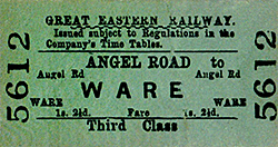
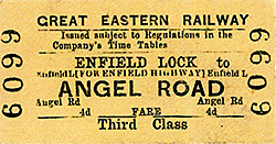
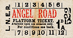
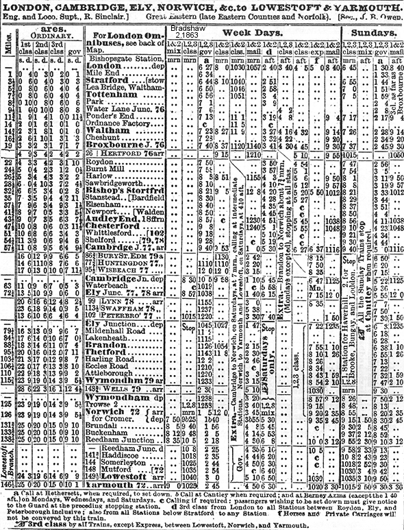
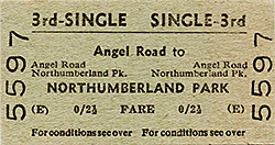
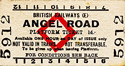
Tickets from Michael Stewart, Totem from Richard Furness, Bradshaw from Alan Young.
Sources:
See also Lower Edmonton Low Level |

road_old8.jpg)
road_old2.jpg)
road_old2.jpg)
road_old3.jpg)
road_old6.jpg) In this view looking north from the up platform at Angel Road station LNER lamp tablets are still in situ but it dates from BR days. The giveaway is the Brylcreem poster on the right. Not obvious, partly because of the lamp post, is that the man on the poster is brushing his hair with both hands. The poster also shows the, then, new style of Brylcreem jar. This particular poster and the new style jar appeared sometime around 1952. Assuming Angel Road received its totem signs around 1955 the date of this photo would be 1952 - 1955. The lamps are gas and fitted with LNER style globes. The waiting room on the down side is at the back of the platform while that on the up side is built on the platform so the canopy on the down side is much wider than that on the up side and is supported by two cast iron columns. Angel Road Junction box is seen in the distance.
In this view looking north from the up platform at Angel Road station LNER lamp tablets are still in situ but it dates from BR days. The giveaway is the Brylcreem poster on the right. Not obvious, partly because of the lamp post, is that the man on the poster is brushing his hair with both hands. The poster also shows the, then, new style of Brylcreem jar. This particular poster and the new style jar appeared sometime around 1952. Assuming Angel Road received its totem signs around 1955 the date of this photo would be 1952 - 1955. The lamps are gas and fitted with LNER style globes. The waiting room on the down side is at the back of the platform while that on the up side is built on the platform so the canopy on the down side is much wider than that on the up side and is supported by two cast iron columns. Angel Road Junction box is seen in the distance.

 Home Page