
Station Name: LOUGHBOROUGH JUNCTION
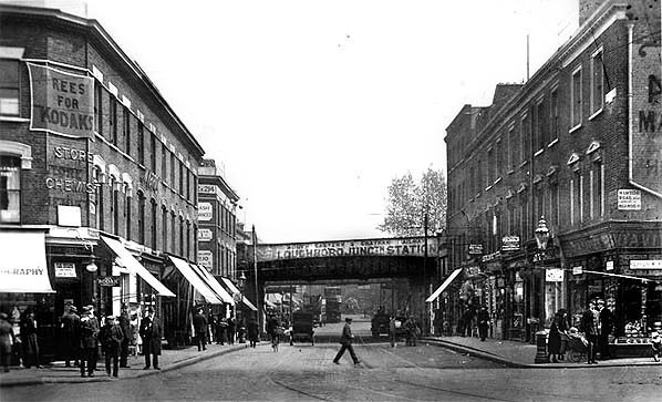 The busy streets around Loughborough Junction station in the early years of the twentieth century - after the introduction of electric trams in 1905.
 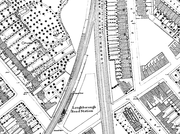 1871 1:1,056 OS Town Plan shows Loughborough Road station, the original two platform station that opened in 1864. The Cambria Road spur was not opened until 1872.
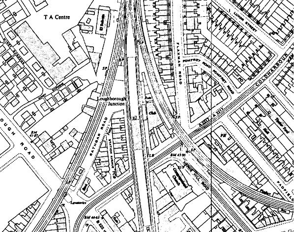
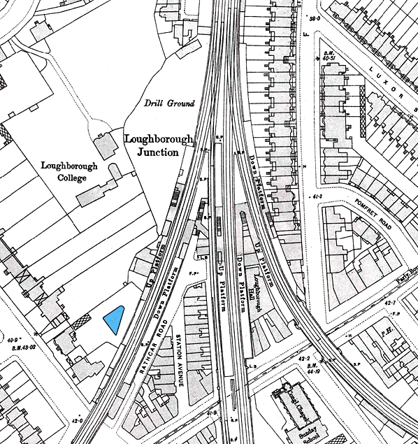 1898 1:1,056 OS Town Plan shows the layout of Loughborough Junction station. The original platforms were those on the left serving Brixton and Victoria; they opened in 1864 and the station was called Loughborough Road. The Herne Hill platforms which opened in 1872 are seen in the centre and comprise an island and a down side platform. The Denmark Hill platforms are seen on the right; these also opened in 1872. Five sets of stairs serve the platforms, reached from an arch beneath the viaduct. The shaded area indicates the extent of the platform canopies. What might be the original station building is between the Denmark Hill and Herne Hill platforms. It is identified here as Loughborough Hall and if it was ever used as a station building it must have been taken out of use at an early date. Click here to see a larger version of this map.
 1952 1:2,600 OS map. By this date only the central island platform remains open. All trace of the Brixton line platforms has gone. The Cambria curve platforms are still shown. The three lines running south have been reduced to two and the island platform has been widened. The possible station building is now identified as a club.
junction_old5.jpg) Loughborough Junction station looking south in 1956. The closed Cambria curve platforms are seen on the left; at this time the platform buildings were intact. The widened island platform is seen in the centre; this was now the only platform still in use. The original street level building is seen between the Herne Hill and Denmark Hill lines.
Photo from John Mann collection junction_old4.jpg) The Cambria curve platforms at Loughborough Junction station in the 1950s. These closed on 12 July 1925 as did the down Herne Hill line platform which is also seen here. After closure the down lines were reduced from two to one and the island platform was widened.
Photo from John Mann collection junction_old2.jpg) Loughborough Junction island platform looking north c late 1950s. The building in the distance on the left is a railway sub-station. This is still in use.
Photo from John Mann collection 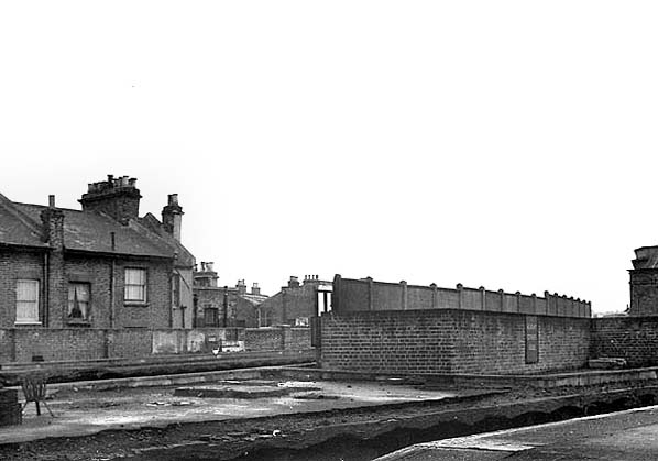 Loughborough Junction disused platform on the Herne Hill line with the Cambria curve platforms behind in October 1967.
Photo by Nick Catford 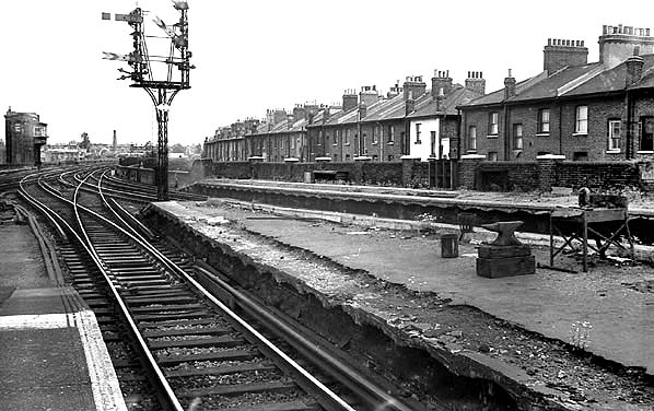 Looking north from the island platform at Loughborough Junction station in May 1968. The closed down Herne Hill platform and the two Denmark Hill platforms are seen on the right. Note the signal box in the distance; this was known as 'The Tower' and opened c1870. It was one of the busiest boxes on the LCDR network with 54 levers. The brick tower was actually taller than it appears here as it was built at ground level beside the viaduct. The box closed on 29 November 1981 in connection with the resignalling of the area under the control of the new Victoria power box.
Photo by Nick Catford junction17.jpg) Looking south at Loughborough Junction station in May 1974 from a train heading east round the Cambria curve. The disused up Peckham platform and down Herne Hill platform are seen..
Photo by Alan Young 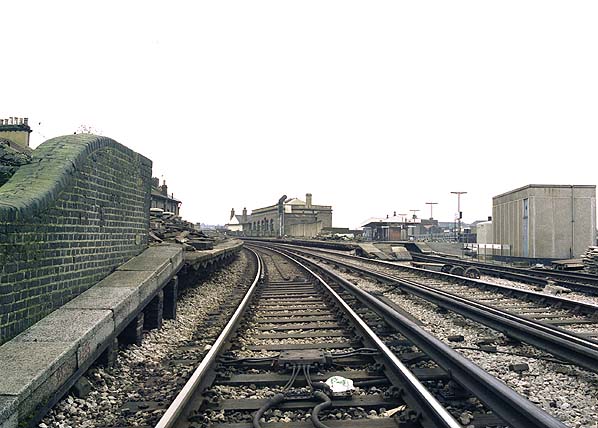 Loughborough
Junction looking south at the Cambria spur platforms in December 1982. The Herne Hill island platform can be seen to the right.
Photo by Nick Catford 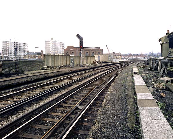 Looking north along the down Cambria curve platform at Loughborough Junction station in December 1982. A railway sub-station is seen beyond the station.
Photo by Nick Catford 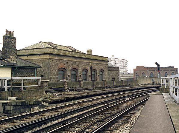 Loughborough Junction station Cambria curve platforms in December 1982. The possible three-storey station building is seen to the rear of the up platform.
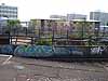
Photo by Nick Catford junction21.jpg) The three disused platforms at Loughborough Junction seen from the current platform 2 in June 2008.
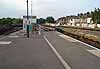
Photo by Alan Young 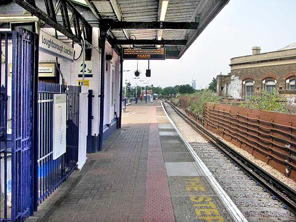 Loughborough Junction station looking north. There were originally two lines here but one was removed and the platform widened over it
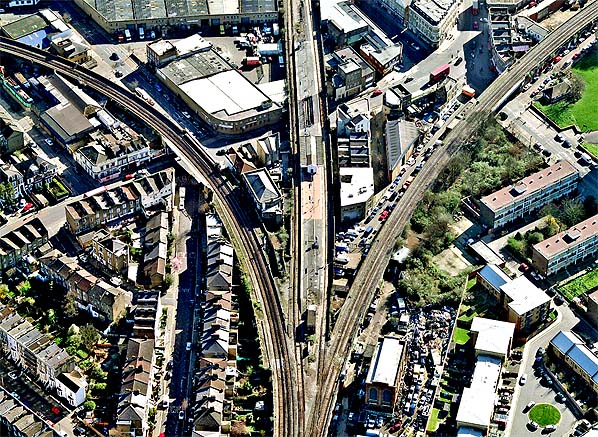 Loughborough Junction station looking south. The Cambria curve is to the left; the platforms can still be seen as can the possible station building between the curve and the Herne Hill line with its wide island platform. To the right is the curve to the Brixton line; all evidence of the platforms was cleared away long ago.. Click here for a larger version.
 Home Page Home Page
|
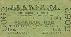
 Notes: The first platforms on what was to later become Loughborough Junction were on the Brixton line which first appeared in public timetables in October 1864, two years after the LCDR's Metropolitan Extension to Victoria opened. The station was called Loughborough Road. From 1 July 1872 three platforms were provided on the Herne Hill lines. At the same time, a spur was built by the Crystal Palace & South London Junction Railway joining the Metropolitan Extension with the line to Peckham. This required the erection of three iron bridges and the demolition of a number of houses in Flaxman Road, Two platforms were provided on the spur which is usually referred to as Cambria Road platforms and spur after nearby Cambria Road. The station was renamed Loughborough Junction on 1 December 1872.
  A three storey brick building was provided in the triangle between the Herne Hill line and the Cambria spur. The building has not been confirmed as the station building. If it was, it was taken out of use at an early date as it is named on the 1898 map below as 'Loughborough Hall'. There is a walk way giving easy access to the front of the building. The rear of the building is conveniently close to the five stairways rising up to the platforms from the arches beneath the viaduct. The building does not appear on the 1871 survey reproduced below so it seems likely it was built at or around the same time as the Cambria curve and platforms. In the 1950s it was being used as a club and in more recent times it became a factory making Snopake correction fluid. Lambeth Council's 2013 regeneration plan for the area describes the building as 'station building' but this could be an assumption. The building does have some architectural resemblance to Denmark Hill although that building is LBSC not LCD. The entrance to the station is now through an arch in the viaduct in Coldharbour Lane.
  After nationalisation the station was part of the Southern Region of British Railways and, from 1986, Network SouthEast. Around 1990 the station became part of the Thameslink route. From 1997-2006, rail services were provided by the Thameslink train operating company. Although this company is now defunct, the Thameslink name continues to be used for the line. Since 2006, the Thameslink line has been operated by First Capital Connect. Most passenger services from Loughborough Junction run between Bedford and Sutton, and additional SouthEastern services run from Loughborough Junction to Beckenham Junction.
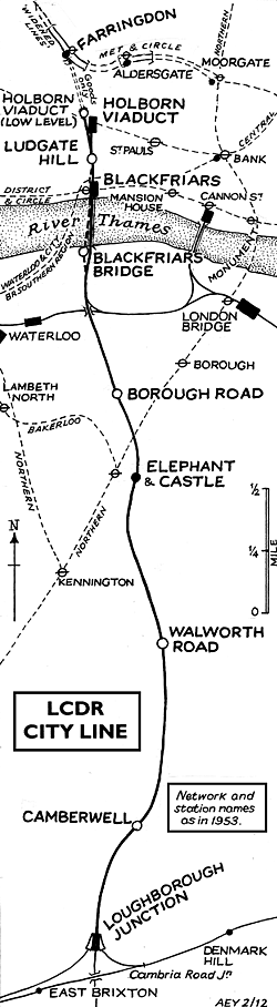 BRIEF HISTORY OF THE LCDR's 'CITY
LINE'
BRIEF HISTORY OF THE LCDR's 'CITY
LINE'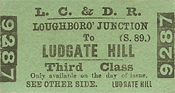 The difficulties of inter-terminal transfer through the congested
streets of mid-Victorian London assured considerable transfer
traffic. All L C D R mainline trains, including continental ones,
carried a City portion attached or detached at Herne Hill. Eventually
however the development of the underground network led to the
withdrawal of the through services and the demise in the importance
of Holborn and Blackfriars with a dramatic reduction in off peak
services. Holborn retained very heavy parcels traffic, including
continental and three of its six platforms, too short for electric
trains were utilised.
The difficulties of inter-terminal transfer through the congested
streets of mid-Victorian London assured considerable transfer
traffic. All L C D R mainline trains, including continental ones,
carried a City portion attached or detached at Herne Hill. Eventually
however the development of the underground network led to the
withdrawal of the through services and the demise in the importance
of Holborn and Blackfriars with a dramatic reduction in off peak
services. Holborn retained very heavy parcels traffic, including
continental and three of its six platforms, too short for electric
trains were utilised.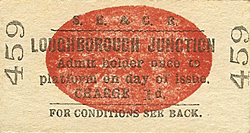 The first casualty on the line was Borough Road which closed
on 1st April 1907 due to competition from the Northern Line. As
an economy measure during WW1 through services from south of the
Thames to Moorgate via the Smithfield Curve (opened 1.9.1871)
were withdrawn on 1st April 1916 with Camberwell and Walworth
Road stations closing two days later. Holborn Viaduct Low Level
closed on 1st June 1916 and with it through passenger traffic
on the City Line ceased.
The first casualty on the line was Borough Road which closed
on 1st April 1907 due to competition from the Northern Line. As
an economy measure during WW1 through services from south of the
Thames to Moorgate via the Smithfield Curve (opened 1.9.1871)
were withdrawn on 1st April 1916 with Camberwell and Walworth
Road stations closing two days later. Holborn Viaduct Low Level
closed on 1st June 1916 and with it through passenger traffic
on the City Line ceased.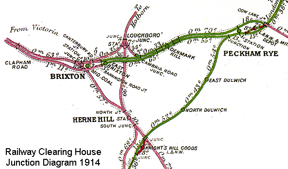
 In 1902, 19.2 million passengers used Holborn, Ludgate and St.
Paul's. Use declined with the loss of the cross London traffic
until electrification. The growth of L.C.C. estates in S E London
and Kent increased traffic but this was not maintained and in
1960 they were back to the 1902 level with 88% of the traffic
arriving or departing during the rush hour. The 'City Line' was
still a vital north-south freight link with some 90 trains a day
in 1962, but all regular freight and parcels services were withdrawn
in 1969. Although disused for many years the Snow Hill tunnel
was finally abandoned in 1971 and the track was lifted.
In 1902, 19.2 million passengers used Holborn, Ludgate and St.
Paul's. Use declined with the loss of the cross London traffic
until electrification. The growth of L.C.C. estates in S E London
and Kent increased traffic but this was not maintained and in
1960 they were back to the 1902 level with 88% of the traffic
arriving or departing during the rush hour. The 'City Line' was
still a vital north-south freight link with some 90 trains a day
in 1962, but all regular freight and parcels services were withdrawn
in 1969. Although disused for many years the Snow Hill tunnel
was finally abandoned in 1971 and the track was lifted.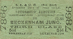 The Snow Hill tunnel was reopened in 1988 as part of the new
  The northern part of the
junction_old_thumb3.jpg)
junction_thumb16.jpg)
junction_thumb18.jpg)
junction_thumb19.jpg)
junction_thumb16.jpg)
junction_thumb20.jpg)
junction_thumb22.jpg)
junction_thumb23.jpg)
junction_thumb12.jpg)
