Station Name: TYNEMOUTH (1st site)

[Source: Alan Young]

Date opened:

1.4.1861 for passengers (31.10.1860 for goods)

Location: North side of Tynemouth Road, immediately east of Northumberland Park. A modern residential cul-de-sac, Hazeldene Court, occupies the site of the station.
Company on opening: Blyth & Tyne Railway
Date closed to passengers: 1863 (Probably 1.1.1863)
Date closed completely: 1.5.1971
Company on closing:

Passengers: Blyth & Tyne Railway. Goods: British Rail (Eastern Region)

Present state: Demolished
County: Northumberland
OS Grid Ref: NZ364691
Date of visit:

12.6.2011

Note: This original B&T terminus had a very short life as a passenger station, being replaced with stations on a new route that diverged south eastwards from the original line. For over a century it survived for goods traffic, reached by a link – including the need for reversal – from the present Tynemouth Metro station. The permanent station building was constructed a few months after the station opened. A booking office, general waiting room and first class ladies’ room were provided.

In 1864, shortly after passenger closure, when open for goods only, the station appears to have been re-named North Shields (presumably to distinguish it from Tynemouth [2nd site]). The OS map of 1865 identifies the station as North Shields Terminus. However the labelling of branch-end stations as Terminus, when the suffix was not that actually used by the railway company, was common OS practice

BRIEF HISTORY OF BLYTH & TYNE RAILWAY (Hartley-Monkseaton ‘Avenue Branch’; Monkseaton / Whitley Bay / Tynemouth area)

The southern end of the Blyth & Tyne Railway has a complicated history. Until 1861 there was a single route south from Blyth and Seghill through Prospect Hill to Percy Main, with a terminus adjacent to the NER station. However that year a new branch was opened, following the route of the former Whitley Waggonway, extending from Hartley to Tynemouth. It should be noted that this included the stretch to what is now Monkseaton, which was to be known as the ‘Avenue Branch’, and that the line beyond to Tynemouth was half a mile inland of the present day Monkseaton – Tynemouth Metro line.

At the Tynemouth end the original terminus was quickly replaced with a new one on a short branch which curved south-eastwards, and that in turn closed when its branch was extended to a third terminus, which adjoined the 1847 Tynemouth terminus of what had been the Newcastle & North Shields Railway. These developments are shown on the series of accompanying maps.

In 1864 the Blyth & Tyne reached Newcastle, with its terminus at New Bridge Street. This was achieved by diverting trains onto a new line just south of Holywell, through Backworth, Benton, and Jesmond. From Backworth a new line was opened to join the 1861 Whitley (Monkseaton) to Tynemouth route. Trains could now travel on the B&T from Newcastle (New Bridge Street) to Tynemouth, making the Holywell – Prospect Hill – Percy Main route, and the Avenue Branch between Hartley and Whitley (Monkseaton) redundant. These two lines closed in June 1864 on the day when the Newcastle – Tynemouth service was inaugurated. In June 1904 the Avenue Branch reopened to passenger traffic.

In 1874 the B&T was absorbed by the NER, and the opportunity was taken to reorganise the railway routes in the Monkseaton / Whitley / Tynemouth area. With the growth of housing and holidaymaking on the coast the ‘inland’ route from Monkseaton to North Shields was superseded in 1882 by one within sight of the sea, and the two formerly competing termini at Tynemouth were replaced with a splendid new through station. This created the coastal section of the familiar Coast Circle and Metro route, although there were to be realignments at Whitley Bay in 1910 and Monkseaton in 1915 where new, larger stations were built.

Click here for a list of sources and a Blyth & Tyne bibliography

1863 Bradshaw from Alan Young. Route map drawn by Alan Young.

To see other stations on the Blyth & Tyne Railway Avenue branch click on the station name: The Avenue, Dairy House, Monkseaton (1st site), Whitley, Cullercoats (1st site), North Shields (B & T) & Tynemouth (3rd site)

See also Seaton Sluice and the unopened Collywell Bay branch: Brierdene & Collywell Bay

See also
West Monkseaton, Monkseaton (2nd site), Whitley Bay (1st site), Whitley Bay (2nd site), Cullercoats (2nd site) & Tynemouth (4th site)

See also
Tynemouth (Newcastle & Berwick terminus)


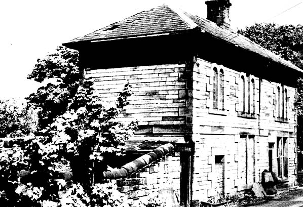
Although this structure adjoined the site of the first B&T Tynemouth station, and has been identified in some sources as the station building, it is unlikely to have been in railway use. (1961)
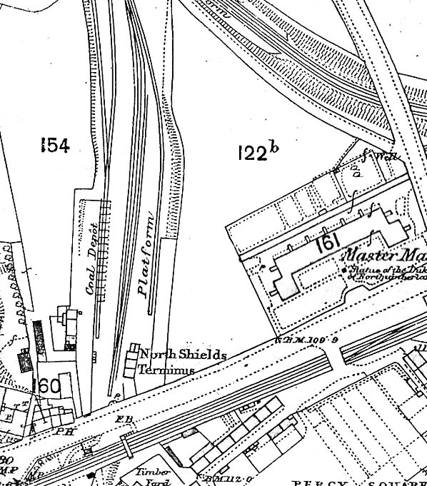
Photo by LG Charlton


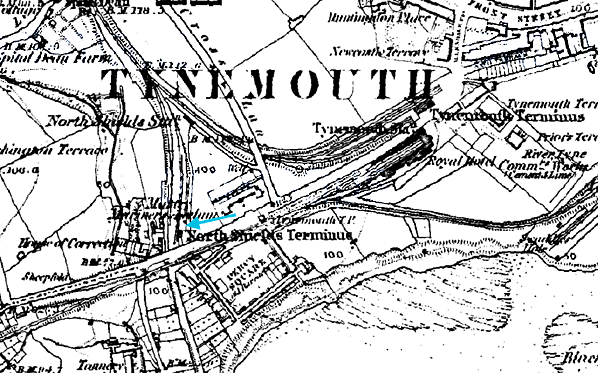
This 1:10,560 map, published in 1865, captures the Tynemouth / North Shields area at a very interesting stage in its railway development. ‘North Shields Terminus’ was the B&T’s Tynemouth (1st) station, opened to goods in 1860 and passengers in 1861. It closed to passengers in 1863 but continued in use for goods traffic under the name of North Shields. The replacement on a new branch to its north was Tynemouth (2nd), but this one was renamed North Shields – as it is shown on the map – when Tynemouth (3rd) was opened on an extension towards the coast (shown as Tynemouth Terminus). The Newcastle & Berwick’s Tynemouth station, by 1865 owned by the North Eastern Railway and including the Royal Hotel, can be seen immediately south of the B&T’s 3rd station.


c1882 1:2,500 OS Map. ‘North Shields Terminus’ was the first Tynemouth passenger terminus of the Blyth & Tyne Railway, opened in 1860. When the second B&T Tynemouth station was opened to the north-east the original one was renamed North Shields (never officially ‘Terminus’) and relegated to handling goods traffic.

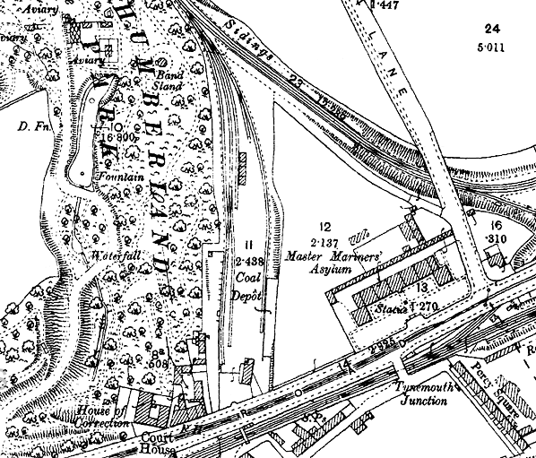
1898 1:2,500 OS Map. Tynemouth (1st) can now be seen as a coal depot, while Tynemouth (2nd) – later ‘North Shields’ – is no longer shown. The current Tynemouth station, east of the map, had been opened by the North Eastern Railway in 1882, replacing the former B&T North Shields and Tynemouth stations and its own earlier terminus.


The coal depot at Tynemouth (1st) station, looking north-west in January 1964. Despite its proximity to the railway site, the building is unlikely to have been associated with the station.
Photo by JC Dean

Tynemouth (1st) station site serving as the coal depot. Looking south-east in April 1972. It is not known if the platform in the foreground was formerly used by passengers.
Photo by JC Dean


Tynemouth (1st) station site serving as the coal depot. Looking north-west in April 1972.
Photo by JC Dean

The site of Tynemouth (1st) station continued to be used as a coal depot until 1971. This view shows the site in April 1972.
Photo by JC Dean

The site of Tynemouth (1st) station continued to be used as a coal depot until 1971. This view shows the site in April 1972. The former coal drops are seen in the foreground.
Photo by JC Dean

The site of Tynemouth (1st) station (later the coal depot) looking north in July 1987.
Photo by John Mann

The site of Tynemouth (1st) station (later the coal depot) looking north in July 1987.
Photo by John Mann

Looking north towards the site of Tynemouth (1st) station, which, in this June 2001 view, is now occupied by a residential development called Hazeldene Court.
P
hoto by Ali Ford


[Source: Alan Young]


Last updated: Friday, 26-May-2017 08:58:31 CEST
© 1998-2012 Disused Stations