
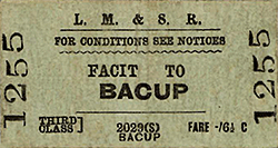
Station Name: FACIT[Source:
Alan Young]
Facit Station Gallery 1: c1910 - c1910
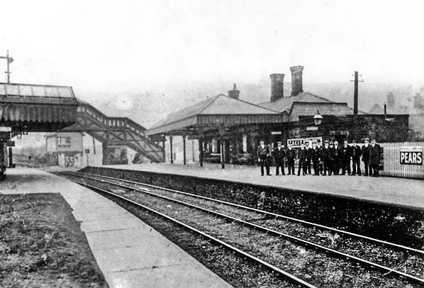
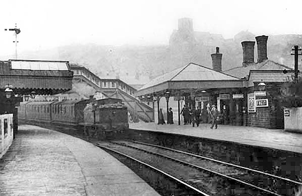 A Rochdale-bound train is entering Facit station c1910. The main station building is on the right, a single-storey stone structure similar to the buildings at Shawclough and Whitworth stations, but given the dignity of a hipped awning in respect of its original status as the northern terminus of the ‘Facit Branch’. A reminder of its conversion to a through station in 1881, when the branch was extended to Bacup, is that the building is aligned to the original position of the platform which was built outwards at the northern end to adjoin the new ‘up’ track. When the second (down) platform was added this was also given a single-storey building but its awning was of a ridge-and-furrow design. An enclosed footbridge connected the platforms at their northern ends. It will be noted that the loco is entering bunker-first. Wray (1989) suggests that because chimney-first running was normal it was probably because of the steep gradients on the line that the reverse practice is seen here: the water in the boiler would not uncover the firebox crown plate when the summit is reached and the engine is on the downhill stretch beyond.
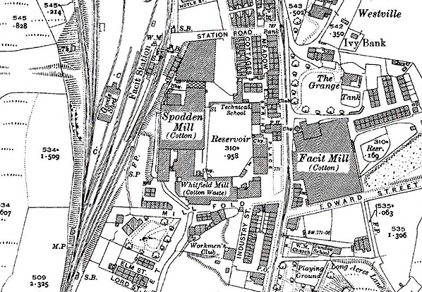
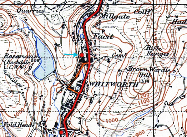  1935 street map.
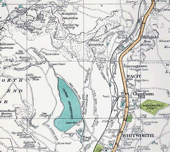
 1894 1: 10,560 OS map. From 1870 until 1881 Facit was the northern terminus of the line from Rochdale, but when the line was extended north to Bacup it swerved slightly westwards at the station, leaving the original building aligned to the old position of the track. The original platform was adjusted to reach the new track and would handle southbound (up) trains while a new down platform was added west of the tracks. The original building has been retained as the principal one. A substantial building, also with a platform awning, stands on the down platform. A footbridge is shown towards the northern end of the platforms. There is a complex arrangement of loops and sidings, and the yard includes a single-road goods warehouse. A siding to the north on the down side extends beyond the station area to serve Facit Quarries on the edge of the moors; it is entered via a reversal, at the northern edge of map extract. There are also nearby sidings for stone traffic alongside a stone processing works. A tramway also extends up the valley side from exchange sidings close to the passenger station; it is not immediately obvious what its purpose was. The almost uninhabited moors to the west contrast starkly with the abundant terraced housing and cotton mills east of the railway.
 1910 1: 2,500 OS map. Facit station’s principal building, on the east (up) platform is shown with its internal divisions, and the pecked lines indicate the extent of the awning over the platform. The internal divisions of the building on the down platform are also marked. The station’s goods facilities, including a warehouse, are seen west of the running lines. The tramway close to the station has been removed.
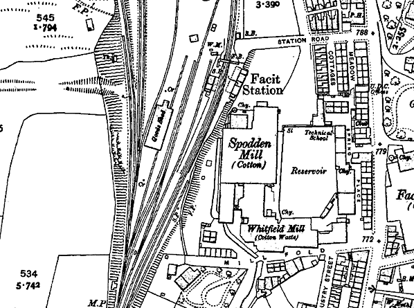
 1929 1: 2,500 OS map. Facit station has undergone little significant change. At this time the mining and manufacturing are still of great importance, despite the economic uncertainties of the Great Depression. Three cotton mills are named, all within convenient walking distance of the station.
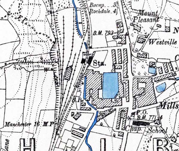
1947 1: 10,560 OS map. This map shows Facit station in the year when the passenger train service was suspended, never to be reinstated. From this time until 1963 Facit was retained as the northern terminus for branch goods traffic.
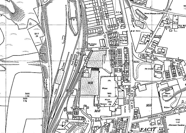 1964 1: 2,500 OS map. Facit station closed to all traffic in 1963 but would have still been in use for goods traffic when the map area was surveyed, thus it is still named. 'The buildings are shown on both platforms, but the only awning is a short one on added to the up (east) platform building to replace the larger, earlier one. The station still possesses a signal cabin and goods warehouse, but some sidings have been removed and the line up to Facit Quarries has been dismantled. Specific mill names and their products are no longer stated as the OS was required to remove such information during the Cold War years in the interests of national security. Click here for a larger version.
 Looking north from the down platform at Facit station c1910. The station staff are standing on the up platform where the principal facilities are located. Both the building and the awning have a hipped profile in contrast to the ridge-and-furrow roof and awning on the down platform. In the background are the stately covered footbridge and the station signal box, both of which received attention under LMS management – the footbridge being replaced and the signal box abolished. Even a station of modest importance such as Facit would be expected to have numerous staff, including stationmaster, booking clerk, porter, goods clerk and signalmen; and it is likely that photos such as this one would be taken at a time of day when staff on different shifts could all be assembled.
Photo from Whitworth Historical Society 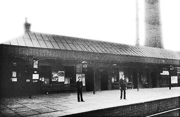 The main building on the up platform of Facit station looking south-east from the down platform c1910. The single-storey stone building is undistinguished, but it is accompanied by a hipped, glazed awning of generous proportions with gas lanterns suspended from it. The perspective looks peculiar, but this is because the building is not aligned with the platform edge. The building was parallel to the original platform when Facit was the temporary northern terminus of the branch from Rochdale between 1870 and 1881. The extended line to Shawforth, Britannia and Bacup veered away from the building and the platform was extended towards the new position of the track. The down platform, from which this photo is taken, was added as the Bacup extension was double track throughout.
Click here for Facit Station Gallery 2:
|
 Notes: Facit is part of the linear industrial area that follows the deep and narrow valley of the River Spodden, and today its Victorian terraces still line the Rochdale–Bacup road. Its prosperity in the nineteenth century depended on its textile mills and the huge quarries on the moors to the north-west. In administrative and commercial terms it has been overshadowed by Whitworth, a mile to the south, and only local people would be able to distinguish where Facit ends and Whitworth begins. However in railway terms Facit was of greater importance, serving for 11 years (1870 to 1881) as the northern terminus of the line before it was extended to Bacup. Traditions die hard, and although no longer a true ‘branch line’ the Rochdale-Bacup route remained the Facit Branch, and LMS timetables for the line were headed ‘Rochdale–Facit–Bacup’, ignoring Whitworth.
 The goods yard was extensive and at one time included a wagon-weighing machine; few stations were provided with this device. There was also an engine shed of timber construction which was in use for just over ten years while Facit was the branch terminus; it was unusual for an LYR branch to possess a shed. The shed was replaced with one at Bacup which remained in use until 1954. One of the goods yard tracks extended beyond railway property to a stone-processing plant further up the valley and then clambered up to the moors via a zig-zag and a standard gauge incline to serve Henry Heys & Sanderson quarries. The zig-zag at the foot of the incline was to prevent accidents should a wagon run out of control down the gradient; it would not foul the running line or enter the goods yard. There were rail connections to further quarries on the moors and to inclines serving the Rossendale Valley (Bacup-Rawtenstall). At the top of the incline was a shed for quarry line locomotives. The quarries were a lucrative source of traffic for the Facit Branch, but the incline ceased to be worked in 1947 when there was a major breakdown, and thereafter stone was moved by road.
 Sometime between March 1939 and December 1940 Facit station signal box closed and two ground frames replaced it, released from Facit Goods Yard box. The station box was soon demolished and a stationmaster’s house was built incorporating its site. Perhaps at the same time the covered footbridge was replaced with a utilitarian open-top model. During World War II the services between Rochdale and Bacup remained fairly frequent although at irregular intervals: a feature of the timetable since the early days of the line. In July 1943 trains left Rochdale for Bacup at the following times: 7.00 and 9.25am; 12.05pm, 1.25, 4.20, 6.30 (Saturday excepted [SX]), 6.45 (Saturday only [SO]), 8.17 and 10.40 (SO). All trains called at Facit. Trains departed from Bacup for Rochdale at 6.41, 7.17, 8.07 and 9.37am; 12.48 (SO), 1.30, 2.07, 3.13 (SO), 4.45 (SO), 5.12 (SX), 5.52, 6.25 (SO) and 7.44. No passenger trains ran on Sunday.
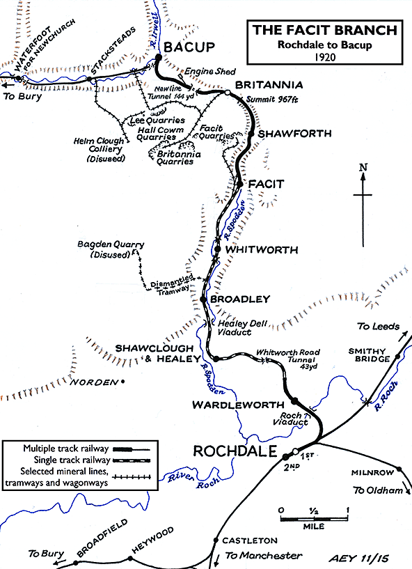
 The last regular LMS passenger trains served Facit in June 1947 when they were suspended, the temporary closure being declared permanent by British Railways (London Midland Region) in December 1949. Goods traffic continued to be handled at Facit for some years, although from May 1952 the line northwards to Bacup engine shed was closed to all traffic. The route was notionally available for wagon storage after this time, but only at Facit station itself did this take place. On 10 November 1956 Facit Goods Yard signal box closed and thereafter the single line to Wardleworth was operated on a ‘One Engine in Steam’ basis.
 Home Page