Station Name: MONKSEATON

[Source: Alan Young]

Date opened:

25.7.1915

Location: Entrances from overbridge on Front Street and directly into main building from Norham Road
Company on opening: North Eastern Railway
Date closed to passengers: Temporary closure from 10.9.1979 until 11.8.1980
Date closed completely: Still open
Company on closing:

British Rail (Eastern Region) temporary closure

Present state:

Main building and glazed platform roofing survive on north-east platform. Covered ramp down to south-west platform. Buildings on this platform have been constructed for Metro use

County: Northumberland
OS Grid Ref: NZ346721
Date of visit:

Frequently 1960-80; 1998 & 24.3.2009

Notes: This station replaced Whitley – later renamed Monkseaton (1st) – on a deviation south of its predecessor. With the growing popularity of the coast from Monkseaton southwards to Tynemouth both for recreation and commuting, Tynemouth and Whitley Bay had been provided with lavish new stations in 1882 and 1910 respectively. At Monkseaton the passenger bookings had soared from 80,219 in 1901 to 241,313 in 1911, as housing was built in the vicinity of the station, and the regular and frequent electric trains (introduced in 1904) had made train travel much more attractive.

Monkseaton was already an interchange station between the electric ‘Coast’ trains and the Avenue Branch to Blyth, Morpeth and Newbiggin. The NER’s intention to build a branch from the station to the village of Seaton Sluice (whose station would be known as Collywell Bay) further justified the creation of yet another large station, which would serve as an
interchange. The new alignment also enabled the NER to abolish a level crossing on the old line and build an overbridge in its stead.

The site of Monkseaton (2nd) was a little to the west of the first station. The building was complete on 31 December 1914 but was not opened until July 1915, by which time the new trackwork was in place. Three platform faces were provided at this new station, designed by NER Chief Architect, William Bell. The north-east (down) platform (number 1) with the main building, was a side platform. Platforms 2 and 3 were an island, with its south-west face intended for branch traffic.

Platform 1 included a wide concourse covered by a glazed, arched roof. This was supported by the main building and a row of square columns, from which a glazed awning was cantilevered out to cover the platform as far as its edge. Between the columns arched braces infilled by quatrefoils and circles; since the cantilevered awning was removed in the 1970s
these decorations are more visible and provide a highly attractive feature. Bill Fawcett’s North Eastern Railway Architecture (volume 3) provides further detail of the roofing.


The main building is a rambling, single-storey affair, modest in comparison with the platform roofing. It is of red brick with some terra cotta detailing, and in the ‘domestic revival’ style. The hipped slate roof line is broken by two large gables, with a glass verandah between them. The platform is entered through a pair of arches. Until c1971 the island platform was sheltered
by a massive glazed verandah, beneath which were undistinguished wooden structures. Lengthy covered ramps provided access to the platforms from the road overbridge. A notable feature of the station which contributed to its sense of spaciousness was the wide gap between the tracks serving platforms 1 and 2 which, until the late 1960s, enclosed areas of mown grass.

The Coast Circle route from Newcastle Central to Jesmond, with Manors (North) replacing New Bridge Street, was opened on 1 January 1909, but until 1917 the new link was used only by Newcastle Central – Benton trains. The summer 1920 timetable shows trains every half hour throughout the day on weekdays, with a more intensive rush hour service, and an hourly service on Sundays. Express services, some of them routed via the East Coast main line between Heaton and Backworth, called at Monkseaton.

By the late-1930s the half-hourly service had increased in frequency to 20-minute intervals on weekdays and half-hourly on Sundays. On summer Sundays in the mid 1950s the same frequency was provided, sometimes with ‘extras’ at particularly busy times; there were hourly Sunday trains in the winter. Monkseaton also acted as a terminus for Avenue Branch trains. In the
1950s and ‘60s, apart from Newcastle Central Monkseaton was the busiest station on the Coast Circle, measured by ticket bookings.


Monkseaton had two signal boxes: West, between the diverging Coast Circle and Avenue Branch tracks, and East, immediately to the east of the island platform. Goods facilities were provided at a dock to the east of platform 1, with two sidings, and there were further sidings (eight in 1940) which branched from the post-1882 route, following the alignment of the ‘inland’ line to Tynemouth that closed to passengers in 1882.

In the LNER era ‘mint imperial’ style electric lamps were installed, carried on swan-neck standards or suspended beneath the platform awnings. The company’s policy was to provide small nameplates to accompany the electric lamps, which they did at Monkseaton. The LNER also fitted running-in boards of a style believed to be unique to the ‘Coast Circle’ incorporating the company’s early diamond logo. In January 1948 the station became part of the nationalised British Railways North Eastern Region, then in January 1967, when the North Eastern Region was abolished it was transferred to the Eastern Region. The LNER nameboards were in place well into the British Railways era, being replaced with tangerine
vitreous enamel boards in about 1960. LNER nameplates were retained until 1971; totem signs were never fitted.

The familiar 1937 electric multiple units on the Coast Circle were eventually condemned as ‘life expired’ by British Rail, and phased out over a two-year period to be replaced with diesel multiple units; the final EMU ran on 17 June 1967. The diesel units provided a slower service, and the longstanding 20-minute frequency of trains was reduced to half-hourly intervals; however an express service each hour called at Monkseaton.

The new Tynerider branded services – the same old DMUs with jolly orange transfers added to them! – were introduced in October 1970, restoring the 20-minute interval service. By this time the formerly dignified station began to look somewhat tired, and the removal of the verandah on the island platform c1971 did nothing to improve matters. In 1971 the inadequate
LNER lighting was removed and tall, vandal-proof standards were installed. The following year black-and-white ‘corporate identity’ signage was added, and soon afterwards the tangerine running-in boards were removed.

Royal Assent was obtained in 1973 for conversion of the route to light rail ‘Metro’ operation, and the DMU service continued as before, until the direct trains between Newcastle Central and West Monkseaton were withdrawn on 23 January 1978 for Metro engineering work to take place. Newcastle could still be reached by train using the slightly longer route via Tynemouth, but these trains ceased on 10 September 1979. Less than a year later, on 11 August 1980 the station reopened on the first phase of the Tyne & Wear Metro, with trains to Tynemouth and the new Haymarket station in central Newcastle.

Under Metro ownership Monkseaton station has been treated well. Together with its neighbours at Whitley Bay and Tynemouth it provides considerable architectural interest and a pleasant environment in which to wait for trains. However the Metro buildings on the island platform at Monkseaton (now serving only as a side platform) are undistinguished and purely
functional.

BRIEF HISTORY OF BLYTH & TYNE RAILWAY (Hartley-Monkseaton ‘Avenue Branch’; Monkseaton / Whitley Bay / Tynemouth area)

The southern end of the Blyth & Tyne Railway has a complicated history. Until 1861 there was a single route south from Blyth and Seghill through Prospect Hill to Percy Main, with a terminus adjacent to the NER station. However that year a new branch was opened, following the route of the former Whitley Waggonway, extending from Hartley to Tynemouth. It should be noted that this included the stretch to what is now Monkseaton, which was to be known as the ‘Avenue Branch’, and that the line beyond to Tynemouth was half a mile inland of the present day Monkseaton – Tynemouth Metro line.

At the Tynemouth end the original terminus was quickly replaced with a new one on a short branch which curved south-eastwards, and that in turn closed when its branch was extended to a third terminus, which adjoined the 1847 Tynemouth terminus of what had been the Newcastle & North Shields Railway. These developments are shown on the series of accompanying maps.

In 1864 the Blyth & Tyne reached Newcastle, with its terminus at New Bridge Street. This was achieved by diverting trains onto a new line just south of Holywell, through Backworth, Benton, and Jesmond. From Backworth a new line was opened to join the 1861 Whitley (Monkseaton) to Tynemouth route. Trains could now travel on the B&T from Newcastle (New Bridge Street) to Tynemouth, making the Holywell – Prospect Hill – Percy Main route, and the Avenue Branch between Hartley and Whitley (Monkseaton) redundant. These two lines closed in June 1864 on the day when the Newcastle – Tynemouth service was inaugurated. In June 1904 the Avenue Branch reopened to passenger traffic.

In 1874 the B&T was absorbed by the NER, and the opportunity was taken to reorganise the railway routes in the Monkseaton / Whitley / Tynemouth area. With the growth of housing and holidaymaking on the coast the ‘inland’ route from Monkseaton to North Shields was superseded in 1882 by one within sight of the sea,
and the two formerly competing termini at Tynemouth were replaced with a splendid new through station. This created the coastal section of the familiar Coast Circle and Metro route, although there were to be realignments at Whitley Bay in 1910 and Monkseaton in 1915 where new, larger stations were built.

Click here for a list of sources and a Blyth & Tyne bibliography

Tickets from Michael Stewart. July 1922 Bradshaw from Chris Totty, March 1961 Bradshaw from Nick Catford. Route map drawn by Alan Young.

To see other stations on the Blyth & Tyne Railway Avenue branch click on the station name: The Avenue, Dairy House, Monkseaton (1st site), Whitley, Cullercoats (1st site), Tynemouth (1st site), North Shields (B & T) & Tynemouth (3rd site)

See also Seaton Sluice and the unopened Collywell Bay branch: Brierdene & Collywell Bay

See also
West Monkseaton, Whitley Bay (1st site), Whitley Bay (2nd site), Cullercoats (2nd site) & Tynemouth (4th site)

See also
Tynemouth (Newcastle & Berwick terminus)


In the 1950s a three-coach push-and-pull train waits at Monkseaton’s down platform. Whilst most of the passenger workings through this station were electric multiple units, Monkseaton was the terminus for steam trains on the Avenue Branch to and from Blyth or Newbiggin, until DMUs replaced them in 1958. Note the large gap between the up and down lines, with areas of lawn maintained between them
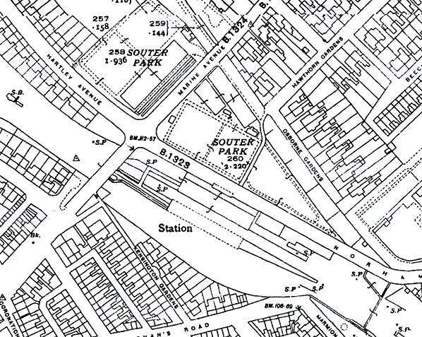
.

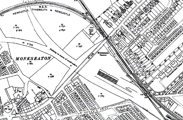
1919 1:2,500 OS map. Although dated 1919 this map shows the state of the railways c1914. Monkseaton (1st) station is shown as open, as on the 1897 map, although it closed in 1915. The realignment which is shown as ‘Railway in course of construction’ was associated with the abortive Collywell Bay (Seaton Sluice) branch project. Trains to Collywell Bay would have been handled at the new, spacious Monkseaton (2nd) station which is shown as partially built: the down platform building and glazed roofing are shown as constructed, whilst no progress had been made on the up platform or its buildings. This new station had, in fact, already been open for four years when the map was published.


1938 1:2,500 OS Map. Monkseaton (2nd) station is complete, but the conspicuous and inexplicable omission of all railway tracks from the map will be noted. Souter Park has been created in the triangular plot between the old and new railway alignments, the old route still clearly visible at the north-east boundary of the park, with the outline of tennis courts (named on the 1958 map) marked on the former trackbed. There is no indication of the large expanse of glazed platform roofing on this edition of the map, and the representation of the up platform buildings with pecked lines is unusual.


1958 1:2,500 OS Map. Unlike the two previous maps, Monkseaton (2nd) station is shown accurately here. Features of interest include the goods sidings and warehouse south-east of the down platform passenger facilities, and the siding behind the up platform which – extended north-westwards – would have accommodated the Collywell Bay shuttle service, had it been introduced as planned in 1914. At the south-east corner a remnant of the earlier inland route to Tynemouth can be seen, which closed in 1882, but survives as sidings in 1958. The wide gap between the passenger lines through the station is used as a series of small lawns at this time.


In the 1950s a three-coach push-and-pull train waits at Monkseaton’s down platform. Whilst most of the passenger workings through this station were electric multiple units, Monkseaton was the terminus for steam trains on the Avenue Branch to and from Blyth or Newbiggin, until DMUs replaced them in 1958. This G5 67281 was built in 1896 at Darlington works. Entering service in the December as NER 1883, it passed to the LNER, renumbered to 7281 in 1937, and was fitted for push-and-pull working. Withdrawn in December 1958 from Blyth (North) Shed, it was scrapped shortly afterwards. Note the large gap between the up and down lines, with areas of lawn maintained between them.
Photo by E E Smith

In the 1950s a three-coach push-and-pull waits at the up face of the island platform of Monkseaton station. The large glass verandah covers platform, and passengers reach it by means of the long covered ramp from the road bridge (extreme right). One of the unusual LNER ‘diamond’ running-in nameboards (in a ‘running-out position!) is partly obscured by the engine, and small LNER nameplates are fixed to lamps, which are also of LNER vintage. The loco 67323 was built in December 1900 to Worsdell Class O design for the NER. This Auto-fitted 0-4-4t was built at the NER’s Darlington works, passed to the LNER and was reclassified G5. Having a working life of 58 years, it was withdrawn from Blyth (North) shed in December 1958 and scrapped in 1959.
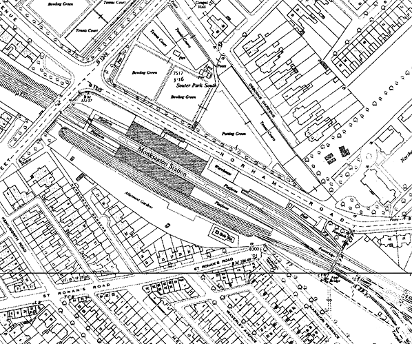
Photo from John Mann collection


Looking east from the down platform at Monkseaton in 1959. The up platform is an island, with few buildings but an extravagant glazed verandah (which was removed c1971). To the right can be seen one of the unusual LNER nameboards incorporating their early ‘diamond’ logo, believed to be unique to the Coast Circle line. The board is unusual too in being placed in a ‘running-out’ position. On the down platform the awning which extended from the main verandah to shelter the platform edge is visible; this was removed when the station was refurbished for Metro use. The signal controls entry to the Avenue Branch. After that ‘branch’ closed in 1964 it would be retained to control a crossover.
Copyright photo from Stations UK

Monkseaton station, looking west from the down face of the island platform in January 1964. No expense was spared in providing this lavish station with its ample glazed roofing in preparation for the opening of the Collywell Bay branch, whose trains would use the south face of the island platform. The station was complete in 1915, but the Collywell Bay branch never opened. Nevertheless Monkseaton was a busy station, with an intensive service of electric trains and large numbers of commuters and visitors to the coast to handle, as well as being a southern terminus for Blyth / Newbiggin trains. In 1964 the lawns in the median between the tracks were still maintained.
Photo by JC Dean


The eastern approaches to Monkseaton station in June 1967. This view shows an EMU at the down platform and, in the foreground, the trackwork before it was rationalised. The electric trains were withdrawn from the middle of the month. The goods warehouse and loading dock are also seen at the back of the down platform. The goods yard closed on 2 March 1959 but private sidings remained in use after that date.

Looking north-west towards Monkseaton station in 1970. The island platform is closest to the camera. Only its north ‘up’ face saw regular passenger services, and by this time the south face was fenced off. Both this platform and the down platform have generous amounts of glass sheltering them.
Photo by JM Fleming

A Class 101 DMU calls at the down platform of Monkseaton on 31 December 1973. At this time the glazed verandah and the awning extending to the edge of the platform are complete. The BR(NE) running-in board is still in place, and corporate identity nameplates have recently been
installed at the station.
Photo by Alan Young


In December 1979 a West Monkseaton to Newcastle Central class 104 DMU calls at the down platform of Monkseaton.
Photo by Alan Lewis from his Flickr photostream

The down platform at Monkseaton, looking east in April 1979. The structure of the glazed roofing can be appreciated. The lengthy iron barrier divides the concourse from the platform.
Photo by Alan Lewis from his Flickr photostream

On 15 August 1998 a Metro train arrives at the down platform of Monkseaton station. The awning in front of the glazed platform roofing has been removed. Beyond the wide gap between the tracks, where there were formerly lawns, the up platform can be seen with its modern Metro buildings, and beyond these the exceptionally long covered ramp leads up to the exit on Front Street.
Photo by Alan Young

A metro train stands in the down platform at Monkseaton station March 2009; seen from the covered ramp from the Front Street entrance.
P
hoto by Nick Catford

Monkseaton station main entrance in Norham Road in March 2009.
P
hoto by Nick Catford

Click here for more pictures of Monkseaton station


[Source: Alan Young]


Last updated: Sunday, 21-May-2017 15:43:01 CEST
© 1998-2012 Disused Stations